Bridge Statistics for North Kingstown, Rhode Island (RI)
Condition, Traffic, Stress, Structural Evaluation, Project Costs
- National Bridge Inventory (NBI) Statistics
- 44Number of bridges
- 348ft / 106mTotal length
- $37,653,000Total costs
- 652,688Total average daily traffic
- 34,703Total average daily truck traffic
- National Bridge Inventory (NBI) Registered Bridges for North Kingstown
- No street view available for this location
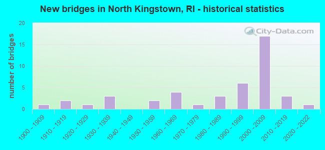
- New bridges - historical statistics
- 11900-1909
- 21910-1919
- 11920-1929
- 31930-1939
- 21950-1959
- 41960-1969
- 11970-1979
- 31980-1989
- 61990-1999
- 172000-2009
- 32010-2019
- 12020-2022

- Reconstructed bridges - Historical Statistics
- 21970-1979
- 31980-1989
- 51990-1999


- Bridge Condition - Deck
- 60.0%Good
- 30.0%Satisfactory
- 10.0%Fair

- Bridge Condition - Superstructure
- 6.5%Very good
- 35.5%Good
- 29.0%Satisfactory
- 19.4%Fair
- 6.5%Poor
- 3.2%Serious

- Bridge Condition - Substructure
- 3.2%Very good
- 58.1%Good
- 22.6%Satisfactory
- 12.9%Fair
- 3.2%Poor

- Bridge Condition - Channel
- 9.1%Very good
- 27.3%Good
- 45.5%Satisfactory
- 18.2%Fair

- Bridge Condition - Culverts
- 33.3%Good
- 66.7%Satisfactory
Find on map >> Show street view
Structure Number: 11, Location: 0.8 Mi S of JCT US1 (Lat: 41.568367, Lng: -71.452131), Route carried "on" structure: Alternate US 1A, Year Built: 1925, Year Reconstructed: 1977, Status: Open, Structure Length: 2.56m (8.40ft), Average Daily Traffic: 13,636 (year 2014), Truck Traffic: 2%, Average Future Daily Traffic: 16,364 (year 2036), Design Load: HS 20, Features Intersected: WICKFORD COVE
Minimum Vertical Clearance: 5.94m (19.49ft), Kilometerpoint: 19.473, Lanes on structure: 2, Base Highway Network: Yes, Owner: State Highway Agency, Approaching Roadway Width: 7.9m (25.9ft), Material/Design: Concrete, Design/Construction: Arch - Thru, Number Of Spans In Main Unit: 1, Length of Maximum Span: 24.4m (80.1ft), Curb or Sidewalk Widths: Left: 1.9m (6.2ft), Right: 1.9m (6.2ft), Curb-To-Curb Width: 7.9m (25.9ft), Out-to-Out Width: 8.7m (28.5ft)
Condition: Deck: Satisfactory, Superstructure: Fair, Substructure: Fair, Channel: Satisfactory, Operating Rating: 93.3 metric tons, Method Used To Determine Operating Rating: Load and Resistance Factor Rating (LRFR) rating reported by rating factor(RF) method using HL-93 loadings, Inventory Rating: 71.9 metric tons, Method Used To Determine Inventory Rating: Load and Resistance Factor Rating (LRFR) rating reported by rating factor(RF) method using HL-93 loadings, Structural Evaluation: Somewhat better than minimum adequacy, Deck Geometry: High priority of replacement, Waterway Adequacy: Better than present minimum criteria, Approach Roadway Alignment: Better than present minimum criteria, Length Of Structure Improvement: 2.80m (9.19ft), Designated Inspection Frequency: Every 24 months, Critical Feature Inspection Frequency: Every 12 months, Underwater Inspection Frequency: Every 48 months, Inspection Date: September 2020, Critical Feature Inspection Date: September 2021, Underwater Inspection Date: September 2020, Bridge Improvement Cost: $1,884,000, Roadway Improvement Cost: $188,000, Total Project Cost: $2,826,000, Deck Structure Type: Concrete Cast-file-Place, Wearing Surface/Protective System: Wearing Surface: Monolithic Concrete
Find on map >> Show street view
Structure Number: 18, Location: 1.2 Mi N of JCT RI 4 (Lat: 41.556797, Lng: -71.464769), Route carried "on" structure: US 1, Year Built: 1917, Year Reconstructed: 1975, Status: Open, Structure Length: 0.74m (2.43ft), Average Daily Traffic: 10,438 (year 2021), Truck Traffic: 5%, Average Future Daily Traffic: 11,482 (year 2041), Design Load: HS 20, Features Intersected: ANNAQUATUCKET RIVER
Minimum Vertical Clearance: 30+ m (98+ ft), Kilometerpoint: 49.624, Lanes on structure: 2, Base Highway Network: Yes, Owner: State Highway Agency, Approaching Roadway Width: 13.4m (44.0ft), Skew: 3 degrees, Material/Design: Concrete, Design/Construction: Culvert, Number Of Spans In Main Unit: 2, Length of Maximum Span: 3.5m (11.5ft)
Condition: Channel: Satisfactory, Culverts: Good, Operating Rating: 97.2 metric tons, Method Used To Determine Operating Rating: Load and Resistance Factor Rating (LRFR) rating reported by rating factor(RF) method using HL-93 loadings, Inventory Rating: 97.2 metric tons, Method Used To Determine Inventory Rating: Load and Resistance Factor Rating (LRFR) rating reported by rating factor(RF) method using HL-93 loadings, Structural Evaluation: Better than present minimum criteria, Waterway Adequacy: Better than present minimum criteria, Approach Roadway Alignment: Better than present minimum criteria, Length Of Structure Improvement: 0.73m (2.40ft), Designated Inspection Frequency: Every 24 months, Inspection Date: November 2021, Bridge Improvement Cost: $370,000, Roadway Improvement Cost: $37,000, Total Project Cost: $556,000, Wearing Surface/Protective System: Wearing Surface: Bituminous, Membrane: Other
Find on map >> Show street view
Structure Number: 37, Location: 1.0 Mi E of JCT US 1 (Lat: 41.519661, Lng: -71.445114), Route carried "on" structure: City street , Year Built: 1993, Status: Posted for load, Structure Length: 1.43m (4.69ft), Average Daily Traffic: 1,500 (year 2014), Truck Traffic: 10%, Average Future Daily Traffic: 1,800 (year 2036), Design Load: HS 20, Features Intersected: MATTATUXET RIVER, Facility Carried by Structure: GILBERT STUART RD
Minimum Vertical Clearance: 30+ m (98+ ft), Kilometerpoint: 1.775, Lanes on structure: 2, Owner: Town or Township Highway Agency, Approaching Roadway Width: 7.0m (23.0ft), Material/Design: Wood or Timber, Number Of Spans In Main Unit: 3, Length of Maximum Span: 5.2m (17.1ft), Curb-To-Curb Width: 6.4m (21.0ft), Out-to-Out Width: 7.4m (24.3ft)
Condition: Deck: Good, Superstructure: Good, Substructure: Fair, Channel: Satisfactory, Operating Rating: 27.4 metric tons, Method Used To Determine Operating Rating: Load and Resistance Factor (LRFR), Inventory Rating: 20.9 metric tons, Method Used To Determine Inventory Rating: Load and Resistance Factor (LRFR), Structural Evaluation: Somewhat better than minimum adequacy, Deck Geometry: High priority of replacement, Waterway Adequacy: Better than present minimum criteria, Approach Roadway Alignment: Better than present minimum criteria, Bridge Posting: Required (Relationship of Operating Rating to Maximum Legal Load: 0.1 - 9.9% below), Length Of Structure Improvement: 1.43m (4.69ft), Designated Inspection Frequency: Every 24 months, Other Special Inspection Frequency: Every 12 months, Inspection Date: December 2021, Other Special Inspection Date: December 2021, Bridge Improvement Cost: $243,000, Roadway Improvement Cost: $24,000, Total Project Cost: $365,000, Deck Structure Type: Wood or Timber, Wearing Surface/Protective System: Wearing Surface: Bituminous, Membrane: Other
Find on map >> Show street view
Structure Number: 78, Location: 2.5 Mi S of JCT US 44 (Lat: 41.832917, Lng: -71.470483), Route carried "on" structure: Alternate City street , Year Built: 1913, Year Reconstructed: 2001, Status: Open, Structure Length: 2.08m (6.82ft), Average Daily Traffic: 14,472 (year 2021), Truck Traffic: 4%, Average Future Daily Traffic: 15,919 (year 2041), Design Load: HS 25 or greater, Features Intersected: WOONASQUATUCKET RIVER, Facility Carried by Structure: MANTON AV
Minimum Vertical Clearance: 30+ m (98+ ft), Kilometerpoint: 0.335, Lanes on structure: 3, Owner: State Highway Agency, Approaching Roadway Width: 11.6m (38.1ft), Skew: 6 degrees, Material/Design: Steel, Design/Construction: Stringer/Multi-beam, Number Of Spans In Main Unit: 1, Length of Maximum Span: 19.0m (62.3ft), Curb or Sidewalk Widths: Left: 1.5m (4.9ft), Right: 1.5m (4.9ft), Curb-To-Curb Width: 11.6m (38.1ft), Out-to-Out Width: 15.8m (51.8ft)
Condition: Deck: Good, Superstructure: Good, Substructure: Good, Channel: Good, Operating Rating: 47.6 metric tons, Method Used To Determine Operating Rating: Load and Resistance Factor Rating (LRFR) rating reported by rating factor(RF) method using HL-93 loadings, Inventory Rating: 36.9 metric tons, Method Used To Determine Inventory Rating: Load and Resistance Factor Rating (LRFR) rating reported by rating factor(RF) method using HL-93 loadings, Structural Evaluation: Better than present minimum criteria, Deck Geometry: High priority of replacement, Waterway Adequacy: Better than present minimum criteria, Approach Roadway Alignment: Better than present minimum criteria, Length Of Structure Improvement: 1.92m (6.30ft), Designated Inspection Frequency: Every 24 months, Inspection Date: March 2021, Bridge Improvement Cost: $659,000, Roadway Improvement Cost: $66,000, Total Project Cost: $989,000, Deck Structure Type: Concrete Cast-file-Place, Wearing Surface/Protective System: Wearing Surface: Bituminous, Membrane: Preformed Fabric, Deck Protection: Epoxy Coated Reinforcing
Find on map >> Show street view
Structure Number: 243, Location: 0.8 Mi S of JCT RI 102 (Lat: 41.573375, Lng: -71.495075), Route carried "on" structure: State highway 4, Year Built: 1953, Year Reconstructed: 1990, Status: Open, Structure Length: 1.92m (6.30ft), Average Daily Traffic: 56,311 (year 2015), Truck Traffic: 2%, Average Future Daily Traffic: 67,574 (year 2036), Design Load: HS 20, Features Intersected: AMTRAK
Minimum Vertical Clearance: 30+ m (98+ ft), Kilometerpoint: 4.606, Lanes on structure: 4, Base Highway Network: Yes, Owner: State Highway Agency, Approaching Roadway Width: 28.0m (91.9ft), Skew: 32 degrees, Material/Design: Steel, Design/Construction: Stringer/Multi-beam, Number Of Spans In Main Unit: 1, Length of Maximum Span: 18.6m (61.0ft), Curb-To-Curb Width: 28.0m (91.9ft), Out-to-Out Width: 30.2m (99.1ft)
Condition: Deck: Good, Superstructure: Fair, Substructure: Satisfactory, Operating Rating: 52.8 metric tons, Method Used To Determine Operating Rating: Load and Resistance Factor Rating (LRFR) rating reported by rating factor(RF) method using HL-93 loadings, Inventory Rating: 40.8 metric tons, Method Used To Determine Inventory Rating: Load and Resistance Factor Rating (LRFR) rating reported by rating factor(RF) method using HL-93 loadings, Structural Evaluation: Somewhat better than minimum adequacy, Deck Geometry: Superior to present desirable criteria, Underclear: High priority of corrective action, Approach Roadway Alignment: Equal to present desirable criteria, Length Of Structure Improvement: 1.92m (6.30ft), Designated Inspection Frequency: Every 24 months, Other Special Inspection Frequency: Every 12 months, Inspection Date: October 2021, Other Special Inspection Date: December 2021, Bridge Improvement Cost: $1,384,000, Roadway Improvement Cost: $138,000, Total Project Cost: $2,076,000, Deck Structure Type: Concrete Cast-file-Place, Wearing Surface/Protective System: Wearing Surface: Bituminous, Membrane: Preformed Fabric, Deck Protection: Epoxy Coated Reinforcing
Find on map >> Show street view
Structure Number: 359, Location: 1.0 Mi S of JCT RI 2 (Lat: 41.546819, Lng: -71.508483), Route carried "on" structure: City street , Year Built: 1930, Year Reconstructed: 1999, Status: Open, Structure Length: 2.51m (8.23ft), Average Daily Traffic: 1,136 (year 2021), Truck Traffic: 18%, Average Future Daily Traffic: 1,250 (year 2041), Design Load: HS 20, Features Intersected: AMTRAK, Facility Carried by Structure: DRY BRIDGE RD
Minimum Vertical Clearance: 30+ m (98+ ft), Kilometerpoint: 1.622, Lanes on structure: 2, Owner: Town or Township Highway Agency, Approaching Roadway Width: 9.1m (29.9ft), Skew: 4 degrees, Material/Design: Steel, Design/Construction: Stringer/Multi-beam, Number Of Spans In Main Unit: 1, Length of Maximum Span: 22.9m (75.1ft), Curb or Sidewalk Widths: Left: 0.0m, Right: 1.5m (4.9ft), Curb-To-Curb Width: 9.1m (29.9ft), Out-to-Out Width: 11.5m (37.7ft)
Condition: Deck: Good, Superstructure: Good, Substructure: Good, Operating Rating: 63.5 metric tons, Method Used To Determine Operating Rating: Load and Resistance Factor Rating (LRFR) rating reported by rating factor(RF) method using HL-93 loadings, Inventory Rating: 48.9 metric tons, Method Used To Determine Inventory Rating: Load and Resistance Factor Rating (LRFR) rating reported by rating factor(RF) method using HL-93 loadings, Structural Evaluation: Better than present minimum criteria, Deck Geometry: Somewhat better than minimum adequacy, Underclear: High priority of corrective action, Approach Roadway Alignment: Somewhat better than minimum adequacy, Length Of Structure Improvement: 2.74m (8.99ft), Designated Inspection Frequency: Every 24 months, Inspection Date: October 2021, Bridge Improvement Cost: $2,116,000, Roadway Improvement Cost: $212,000, Total Project Cost: $3,174,000, Deck Structure Type: Concrete Cast-file-Place, Wearing Surface/Protective System: Wearing Surface: Bituminous
Find on map >> Show street view
Structure Number: 368, Location: 0.6 Mi E of JCT US 1 (Lat: 41.636089, Lng: -71.457878), Route carried "on" structure: City street , Year Built: 1979, Status: Posted for load, Structure Length: 1.54m (5.05ft), Average Daily Traffic: 747 (year 2021), Truck Traffic: 6%, Average Future Daily Traffic: 822 (year 2041), Design Load: HS 20, Features Intersected: POTOWOMUT POND, Facility Carried by Structure: AUSTIN RD
Minimum Vertical Clearance: 30+ m (98+ ft), Kilometerpoint: 0.938, Lanes on structure: 2, Owner: Town or Township Highway Agency, Approaching Roadway Width: 8.5m (27.9ft), Material/Design: Prestressed concrete, Design/Construction: Slab, Number Of Spans In Main Unit: 1, Length of Maximum Span: 14.4m (47.2ft), Curb or Sidewalk Widths: Left: 1.4m (4.6ft), Right: 1.4m (4.6ft), Curb-To-Curb Width: 8.5m (27.9ft), Out-to-Out Width: 12.1m (39.7ft)
Condition: Deck: Satisfactory, Superstructure: Poor, Substructure: Satisfactory, Channel: Good, Operating Rating: 29.8 metric tons, Method Used To Determine Operating Rating: Load and Resistance Factor (LRFR), Inventory Rating: 22.9 metric tons, Method Used To Determine Inventory Rating: Load and Resistance Factor (LRFR), Structural Evaluation: Meets minimum limits, Deck Geometry: Somewhat better than minimum adequacy, Waterway Adequacy: Better than present minimum criteria, Approach Roadway Alignment: Somewhat better than minimum adequacy, Bridge Posting: Required (Relationship of Operating Rating to Maximum Legal Load: 0.1 - 9.9% below), Length Of Structure Improvement: 1.49m (4.89ft), Designated Inspection Frequency: Every 24 months, Other Special Inspection Frequency: Every 12 months, Inspection Date: November 2021, Other Special Inspection Date: November 2021, Bridge Improvement Cost: $375,000, Roadway Improvement Cost: $37,000, Total Project Cost: $562,000
Find on map >> Show street view
Structure Number: 369, Location: 1.0 Mi N of JCT US 1 (Lat: 41.614319, Lng: -71.474342), Route carried "on" structure: City street , Year Built: 2007, Status: Posted for load, Structure Length: 3.59m (11.78ft), Average Daily Traffic: 5,252 (year 2015), Truck Traffic: 5%, Average Future Daily Traffic: 6,303 (year 2036), Design Load: HS 25 or greater, Features Intersected: AMTRAK, Facility Carried by Structure: DEVILS FOOT RD
Minimum Vertical Clearance: 30+ m (98+ ft), Kilometerpoint: 2.015, Lanes on structure: 2, Owner: State Highway Agency, Approaching Roadway Width: 12.2m (40.0ft), Skew: 4 degrees, Material/Design: Prestressed concrete, Design/Construction: Box Beam or Girders - Multiple, Number Of Spans In Main Unit: 1, Length of Maximum Span: 34.5m (113.2ft), Curb or Sidewalk Widths: Left: 1.5m (4.9ft), Right: 1.5m (4.9ft), Curb-To-Curb Width: 12.2m (40.0ft), Out-to-Out Width: 15.8m (51.8ft)
Condition: Deck: Satisfactory, Superstructure: Poor, Substructure: Good, Operating Rating: 70.3 metric tons, Method Used To Determine Operating Rating: Load and Resistance Factor Rating (LRFR) rating reported by rating factor(RF) method using HL-93 loadings, Inventory Rating: 32.4 metric tons, Method Used To Determine Inventory Rating: Load and Resistance Factor Rating (LRFR) rating reported by rating factor(RF) method using HL-93 loadings, Structural Evaluation: Meets minimum limits, Deck Geometry: Somewhat better than minimum adequacy, Underclear: Meets minimum limits, Approach Roadway Alignment: Equal to present minimum criteria, Bridge Posting: Required (Relationship of Operating Rating to Maximum Legal Load: > 39.9% below), Length Of Structure Improvement: 2.50m (8.20ft), Designated Inspection Frequency: Every 24 months, Other Special Inspection Frequency: Every 12 months, Inspection Date: October 2021, Other Special Inspection Date: October 2021, Bridge Improvement Cost: $822,000, Roadway Improvement Cost: $82,000, Total Project Cost: $1,233,000, Deck Structure Type: Concrete Cast-file-Place, Wearing Surface/Protective System: Wearing Surface: Monolithic Concrete, Membrane: Epoxy
Find on map >> Show street view
Structure Number: 37, Location: 0.8 Mi E of JCT RI 2 (Lat: 41.542617, Lng: -71.510589), Route carried "on" structure: City street , Year Built: 1936, Status: Open, Structure Length: 1.84m (6.04ft), Average Daily Traffic: 1,787 (year 2021), Truck Traffic: 14%, Average Future Daily Traffic: 1,966 (year 2041), Design Load: HS 20, Features Intersected: AMTRAK, Facility Carried by Structure: EXETER RD
Minimum Vertical Clearance: 30+ m (98+ ft), Kilometerpoint: 1.978, Lanes on structure: 2, Owner: State Highway Agency, Approaching Roadway Width: 10.4m (34.1ft), Material/Design: Steel, Design/Construction: Stringer/Multi-beam, Number Of Spans In Main Unit: 1, Length of Maximum Span: 17.8m (58.4ft), Curb or Sidewalk Widths: Left: 2.1m (6.9ft), Right: 0.0m, Curb-To-Curb Width: 10.4m (34.1ft), Out-to-Out Width: 13.3m (43.6ft)
Condition: Deck: Fair, Superstructure: Fair, Substructure: Fair, Operating Rating: 33.0 metric tons, Method Used To Determine Operating Rating: Load and Resistance Factor Rating (LRFR) rating reported by rating factor(RF) method using HL-93 loadings, Inventory Rating: 25.6 metric tons, Method Used To Determine Inventory Rating: Load and Resistance Factor Rating (LRFR) rating reported by rating factor(RF) method using HL-93 loadings, Structural Evaluation: Somewhat better than minimum adequacy, Deck Geometry: Equal to present minimum criteria, Underclear: High priority of corrective action, Approach Roadway Alignment: Better than present minimum criteria, Length Of Structure Improvement: 1.89m (6.20ft), Designated Inspection Frequency: Every 24 months, Inspection Date: December 2021, Bridge Improvement Cost: $603,000, Roadway Improvement Cost: $60,000, Total Project Cost: $905,000, Deck Structure Type: Concrete Cast-file-Place
Find on map >> Show street view
Structure Number: 601, Location: 0.1 Mi S of JCT RI 102 (Lat: 41.565736, Lng: -71.456672), Route carried "on" structure: Alternate Other road , Year Built: 1996, Status: Open, Structure Length: 1.07m (3.51ft), Average Daily Traffic: 57 (year 2021), Truck Traffic: 2%, Average Future Daily Traffic: 63 (year 2041), Design Load: H 20, Features Intersected: Wickford Cove, Facility Carried by Structure: Loop Drive
Minimum Vertical Clearance: 30+ m (98+ ft), Kilometerpoint: 0.377, Lanes on structure: 2, Owner: Town or Township Highway Agency, Approaching Roadway Width: 4.8m (15.7ft), Design/Construction: Culvert, Number Of Spans In Main Unit: 4, Length of Maximum Span: 1.9m (6.2ft), Curb-To-Curb Width: 4.8m (15.7ft), Out-to-Out Width: 9.8m (32.2ft)
Condition: Channel: Fair, Culverts: Satisfactory, Operating Rating: 44.7 metric tons, Method Used To Determine Operating Rating: Load and Resistance Factor Rating (LRFR) rating reported by rating factor(RF) method using HL-93 loadings, Inventory Rating: 44.1 metric tons, Method Used To Determine Inventory Rating: Load and Resistance Factor Rating (LRFR) rating reported by rating factor(RF) method using HL-93 loadings, Structural Evaluation: Equal to present minimum criteria, Deck Geometry: High priority of replacement, Waterway Adequacy: Somewhat better than minimum adequacy, Approach Roadway Alignment: Better than present minimum criteria, Length Of Structure Improvement: 0.70m (2.30ft), Designated Inspection Frequency: Every 24 months, Inspection Date: August 2021, Bridge Improvement Cost: $219,000, Roadway Improvement Cost: $22,000, Total Project Cost: $328,000
Find on map >> Show street view
Structure Number: 768, Location: 0.7 Mi S of JCT RI 2 (Lat: 41.594478, Lng: -71.498842), Route carried "on" structure: State highway 4, Year Built: 1988, Year Reconstructed: 1991, Status: Open, Structure Length: 4.27m (14.01ft), Average Daily Traffic: 63,500 (year 2021), Truck Traffic: 16%, Average Future Daily Traffic: 69,850 (year 2041), Design Load: HS 20, Features Intersected: STONY LANE,Scrbbltwn Brk
Minimum Vertical Clearance: 30+ m (98+ ft), Kilometerpoint: 7.305, Lanes on structure: 4, Lanes under structure: 2, Base Highway Network: Yes, Owner: State Highway Agency, Approaching Roadway Width: 24.4m (80.1ft), Skew: 12 degrees, Material/Design: Steel continuous, Design/Construction: Stringer/Multi-beam, Number Of Spans In Main Unit: 2, Length of Maximum Span: 23.7m (77.8ft), Curb-To-Curb Width: 24.4m (80.1ft), Out-to-Out Width: 26.5m (86.9ft)
Condition: Deck: Satisfactory, Superstructure: Fair, Substructure: Good, Channel: Good, Operating Rating: 27.5 metric tons, Method Used To Determine Operating Rating: Load and Resistance Factor Rating (LRFR) rating reported by rating factor(RF) method using HL-93 loadings, Inventory Rating: 19.8 metric tons, Method Used To Determine Inventory Rating: Load and Resistance Factor Rating (LRFR) rating reported by rating factor(RF) method using HL-93 loadings, Structural Evaluation: Somewhat better than minimum adequacy, Deck Geometry: Superior to present desirable criteria, Underclear: Equal to present minimum criteria, Waterway Adequacy: Superior to present desirable criteria, Approach Roadway Alignment: Better than present minimum criteria, Length Of Structure Improvement: 4.27m (14.01ft), Designated Inspection Frequency: Every 24 months, Inspection Date: April 2020, Total Project Cost: $3,493,000, Deck Structure Type: Concrete Cast-file-Place, Wearing Surface/Protective System: Wearing Surface: Bituminous, Membrane: Preformed Fabric, Deck Protection: Epoxy Coated Reinforcing
Find on map >> Show street view
Structure Number: 78, Location: 1.0 Mi S of Int Stny Lane (Lat: 41.581133, Lng: -71.503281), Route carried "on" structure: State highway 4, Year Built: 1988, Year Reconstructed: 1991, Status: Open, Structure Length: 3.99m (13.09ft), Average Daily Traffic: 56,311 (year 2015), Truck Traffic: 2%, Average Future Daily Traffic: 67,574 (year 2036), Design Load: HS 20, Features Intersected: RI 102 VICTORY HWY
Minimum Vertical Clearance: 30+ m (98+ ft), Kilometerpoint: 5.707, Lanes on structure: 5, Lanes under structure: 4, Base Highway Network: Yes, Owner: State Highway Agency, Approaching Roadway Width: 28.9m (94.8ft), Skew: 30 degrees, Material/Design: Steel, Design/Construction: Stringer/Multi-beam, Number Of Spans In Main Unit: 1, Length of Maximum Span: 38.5m (126.3ft), Curb-To-Curb Width: 28.9m (94.8ft), Out-to-Out Width: 31.5m (103.3ft)
Condition: Deck: Good, Superstructure: Satisfactory, Substructure: Good, Operating Rating: 48.3 metric tons, Method Used To Determine Operating Rating: Load and Resistance Factor Rating (LRFR) rating reported by rating factor(RF) method using HL-93 loadings, Inventory Rating: 37.3 metric tons, Method Used To Determine Inventory Rating: Load and Resistance Factor Rating (LRFR) rating reported by rating factor(RF) method using HL-93 loadings, Structural Evaluation: Equal to present minimum criteria, Deck Geometry: Superior to present desirable criteria, Underclear: Equal to present minimum criteria, Approach Roadway Alignment: Equal to present desirable criteria, Length Of Structure Improvement: 3.87m (12.70ft), Designated Inspection Frequency: Every 24 months, Inspection Date: March 2020, Total Project Cost: $3,733,000, Deck Structure Type: Concrete Cast-file-Place, Wearing Surface/Protective System: Wearing Surface: Bituminous, Membrane: Preformed Fabric, Deck Protection: Epoxy Coated Reinforcing
Find on map >> Show street view
Structure Number: 7815, Location: 0.7 Mi S of JCT RI 2 (Lat: 41.571553, Lng: -71.493133), Route carried "on" structure: State highway 4, Year Built: 2019, Status: Open, Structure Length: 2.49m (8.17ft), Average Daily Traffic: 64,455 (year 2018), Truck Traffic: 3%, Average Future Daily Traffic: 67,574 (year 2036), Design Load: HL 93, Features Intersected: LAFAYETTE RD
Minimum Vertical Clearance: 30+ m (98+ ft), Kilometerpoint: 4.345, Lanes on structure: 4, Lanes under structure: 2, Base Highway Network: Yes, Owner: State Highway Agency, Approaching Roadway Width: 23.9m (78.4ft), Skew: 32 degrees, Material/Design: Steel, Design/Construction: Stringer/Multi-beam, Number Of Spans In Main Unit: 1, Length of Maximum Span: 24.3m (79.7ft), Curb-To-Curb Width: 23.9m (78.4ft), Out-to-Out Width: 26.1m (85.6ft)
Condition: Deck: Good, Superstructure: Very good, Substructure: Good, Operating Rating: 53.5 metric tons, Method Used To Determine Operating Rating: Load and Resistance Factor Rating (LRFR) rating reported by rating factor(RF) method using HL-93 loadings, Inventory Rating: 41.5 metric tons, Method Used To Determine Inventory Rating: Load and Resistance Factor Rating (LRFR) rating reported by rating factor(RF) method using HL-93 loadings, Structural Evaluation: Better than present minimum criteria, Deck Geometry: Superior to present desirable criteria, Underclear: Somewhat better than minimum adequacy, Approach Roadway Alignment: Better than present minimum criteria, Length Of Structure Improvement: 2.44m (8.01ft), Designated Inspection Frequency: Every 24 months, Inspection Date: November 2021, Total Project Cost: $1,988,000, Deck Structure Type: Concrete Cast-file-Place, Wearing Surface/Protective System: Wearing Surface: Other, Membrane: Other, Deck Protection: Galvanized Reinforcing
Find on map >> Show street view
Structure Number: 783, Location: 0.5 Mi E of JCT RI 2 (Lat: 41.570008, Lng: -71.496775), Route carried "on" structure: City street , Year Built: 1901, Year Reconstructed: 1991, Status: Open, Structure Length: 1.71m (5.61ft), Average Daily Traffic: 606 (year 2021), Truck Traffic: 11%, Average Future Daily Traffic: 667 (year 2041), Design Load: HS 20, Features Intersected: AMTRAK, Facility Carried by Structure: HATCHERY RD
Minimum Vertical Clearance: 30+ m (98+ ft), Kilometerpoint: 2.359, Lanes on structure: 2, Owner: State Highway Agency, Approaching Roadway Width: 9.1m (29.9ft), Material/Design: Prestressed concrete, Design/Construction: Box Beam or Girders - Multiple, Number Of Spans In Main Unit: 1, Length of Maximum Span: 16.5m (54.1ft), Curb or Sidewalk Widths: Left: 1.2m (3.9ft), Right: 1.2m (3.9ft), Curb-To-Curb Width: 9.1m (29.9ft), Out-to-Out Width: 12.2m (40.0ft)
Condition: Deck: Fair, Superstructure: Serious, Substructure: Good, Operating Rating: 34.0 metric tons, Method Used To Determine Operating Rating: Load and Resistance Factor Rating (LRFR) rating reported by rating factor(RF) method using HL-93 loadings, Inventory Rating: 26.2 metric tons, Method Used To Determine Inventory Rating: Load and Resistance Factor Rating (LRFR) rating reported by rating factor(RF) method using HL-93 loadings, Structural Evaluation: High priority of corrective action, Deck Geometry: Equal to present minimum criteria, Underclear: High priority of corrective action, Approach Roadway Alignment: Better than present minimum criteria, Length Of Structure Improvement: 1.71m (5.61ft), Designated Inspection Frequency: Every 24 months, Other Special Inspection Frequency: Every 12 months, Inspection Date: August 2021, Other Special Inspection Date: August 2021, Bridge Improvement Cost: $13,000, Roadway Improvement Cost: $1,000, Total Project Cost: $19,000, Deck Structure Type: Other, Wearing Surface/Protective System: Wearing Surface: Bituminous, Membrane: Built-up, Deck Protection: Epoxy Coated Reinforcing
Find on map >> Show street view
Structure Number: 839, Location: 2.0 Mi E of JCT US 1 (Lat: 41.530233, Lng: -71.417633), Route carried "on" structure: State highway 138, Year Built: 1993, Status: Open, Structure Length: 1.76m (5.77ft), Average Daily Traffic: 33,100 (year 2021), Truck Traffic: 4%, Average Future Daily Traffic: 36,410 (year 2041), Design Load: HS 20, Features Intersected: FISHING PIER ACCESS RD
Minimum Vertical Clearance: 30+ m (98+ ft), Kilometerpoint: 43.209, Lanes on structure: 4, Lanes under structure: 2, Base Highway Network: Yes, Owner: State Toll Authority, Approaching Roadway Width: 21.6m (70.9ft), Skew: 33 degrees, Material/Design: Steel, Design/Construction: Stringer/Multi-beam, Number Of Spans In Main Unit: 1, Length of Maximum Span: 16.2m (53.1ft), Curb or Sidewalk Widths: Left: 1.0m (3.3ft), Right: 1.0m (3.3ft), Curb-To-Curb Width: 21.6m (70.9ft), Out-to-Out Width: 25.6m (84.0ft)
Condition: Deck: Satisfactory, Superstructure: Fair, Substructure: Good, Operating Rating: 65.8 metric tons, Method Used To Determine Operating Rating: Load and Resistance Factor Rating (LRFR) rating reported by rating factor(RF) method using HL-93 loadings, Inventory Rating: 50.5 metric tons, Method Used To Determine Inventory Rating: Load and Resistance Factor Rating (LRFR) rating reported by rating factor(RF) method using HL-93 loadings, Structural Evaluation: Somewhat better than minimum adequacy, Deck Geometry: Better than present minimum criteria, Underclear: High priority of corrective action, Approach Roadway Alignment: Equal to present desirable criteria, Length Of Structure Improvement: 2.13m (6.99ft), Designated Inspection Frequency: Every 24 months, Inspection Date: March 2020, Bridge Improvement Cost: $1,024,000, Roadway Improvement Cost: $102,000, Total Project Cost: $1,536,000, Deck Structure Type: Concrete Cast-file-Place, Wearing Surface/Protective System: Wearing Surface: Bituminous
Find on map >> Show street view
Structure Number: 895, Location: 1.0 Mi E of JCT RI 2 (Lat: 41.592192, Lng: -71.485594), Route carried "on" structure: City street , Year Built: 1930, Year Reconstructed: 1998, Status: Posted for load, Structure Length: 1.46m (4.79ft), Average Daily Traffic: 4,033 (year 2021), Truck Traffic: 7%, Average Future Daily Traffic: 4,436 (year 2041), Design Load: HS 20, Features Intersected: AMTRAK, Facility Carried by Structure: STONY LANE
Minimum Vertical Clearance: 30+ m (98+ ft), Kilometerpoint: 6.622, Lanes on structure: 2, Owner: Town or Township Highway Agency, Approaching Roadway Width: 9.1m (29.9ft), Material/Design: Prestressed concrete, Design/Construction: Box Beam or Girders - Multiple, Number Of Spans In Main Unit: 1, Length of Maximum Span: 13.9m (45.6ft), Curb or Sidewalk Widths: Left: 1.5m (4.9ft), Right: 0.0m, Curb-To-Curb Width: 9.1m (29.9ft), Out-to-Out Width: 11.6m (38.1ft)
Condition: Deck: Satisfactory, Superstructure: Satisfactory, Substructure: Satisfactory, Operating Rating: 31.4 metric tons, Method Used To Determine Operating Rating: Load and Resistance Factor Rating (LRFR) rating reported by rating factor(RF) method using HL-93 loadings, Inventory Rating: 23.0 metric tons, Method Used To Determine Inventory Rating: Load and Resistance Factor Rating (LRFR) rating reported by rating factor(RF) method using HL-93 loadings, Structural Evaluation: Equal to present minimum criteria, Deck Geometry: Meets minimum limits, Underclear: High priority of corrective action, Approach Roadway Alignment: Somewhat better than minimum adequacy, Bridge Posting: Required (Relationship of Operating Rating to Maximum Legal Load: > 39.9% below), Length Of Structure Improvement: 1.92m (6.30ft), Designated Inspection Frequency: Every 24 months, Other Special Inspection Frequency: Every 12 months, Inspection Date: October 2021, Other Special Inspection Date: October 2021, Bridge Improvement Cost: $1,087,000, Roadway Improvement Cost: $109,000, Total Project Cost: $1,631,000, Deck Structure Type: Concrete Precast Panels, Wearing Surface/Protective System: Wearing Surface: Bituminous, Membrane: Preformed Fabric
Find on map >> Show street view
Structure Number: 896, Location: 0.5 Mi S of JCT RI 4 (Lat: 41.530147, Lng: -71.466097), Route carried "on" structure: US 1, Year Built: 1969, Status: Open, Structure Length: 5.26m (17.26ft), Average Daily Traffic: 46,800 (year 2015), Truck Traffic: 8%, Average Future Daily Traffic: 56,160 (year 2036), Design Load: HS 20, Features Intersected: RI 138
Minimum Vertical Clearance: 30+ m (98+ ft), Kilometerpoint: 46.475, Lanes on structure: 6, Lanes under structure: 5, Base Highway Network: Yes, Owner: State Highway Agency, Approaching Roadway Width: 28.5m (93.5ft), Skew: 30 degrees, Material/Design: Steel continuous, Design/Construction: Stringer/Multi-beam, Number Of Spans In Main Unit: 2, Length of Maximum Span: 25.5m (83.7ft), Curb-To-Curb Width: 28.5m (93.5ft), Out-to-Out Width: 30.6m (100.4ft)
Condition: Deck: Fair, Superstructure: Satisfactory, Substructure: Poor, Operating Rating: 26.9 metric tons, Method Used To Determine Operating Rating: Load and Resistance Factor Rating (LRFR) rating reported by rating factor(RF) method using HL-93 loadings, Inventory Rating: 20.7 metric tons, Method Used To Determine Inventory Rating: Load and Resistance Factor Rating (LRFR) rating reported by rating factor(RF) method using HL-93 loadings, Structural Evaluation: Meets minimum limits, Deck Geometry: Better than present minimum criteria, Underclear: Better than present minimum criteria, Approach Roadway Alignment: Better than present minimum criteria, Length Of Structure Improvement: 5.09m (16.70ft), Designated Inspection Frequency: Every 24 months, Other Special Inspection Frequency: Every 12 months, Inspection Date: October 2020, Other Special Inspection Date: September 2021, Bridge Improvement Cost: $1,595,000, Roadway Improvement Cost: $160,000, Total Project Cost: $2,393,000, Deck Structure Type: Concrete Cast-file-Place, Wearing Surface/Protective System: Wearing Surface: Bituminous, Membrane: Other
Find on map >> Show street view
Structure Number: 898, Location: 0.5 Mi W of JCT RI 138 (Lat: 41.527906, Lng: -71.439786), Route carried "on" structure: State highway 138, Year Built: 1969, Year Reconstructed: 1990, Status: Open, Structure Length: 2.35m (7.71ft), Average Daily Traffic: 36,000 (year 2015), Truck Traffic: 1%, Average Future Daily Traffic: 43,200 (year 2036), Design Load: HS 20, Features Intersected: GILBERT STUART RD
Minimum Vertical Clearance: 30+ m (98+ ft), Kilometerpoint: 41.085, Lanes on structure: 4, Lanes under structure: 2, Base Highway Network: Yes, Owner: State Highway Agency, Approaching Roadway Width: 27.4m (89.9ft), Skew: 32 degrees, Material/Design: Prestressed concrete, Design/Construction: Stringer/Multi-beam, Number Of Spans In Main Unit: 1, Length of Maximum Span: 19.5m (64.0ft), Curb-To-Curb Width: 24.8m (81.4ft), Out-to-Out Width: 26.7m (87.6ft)
Condition: Deck: Satisfactory, Superstructure: Fair, Substructure: Fair, Operating Rating: 36.9 metric tons, Method Used To Determine Operating Rating: Load and Resistance Factor Rating (LRFR) rating reported by rating factor(RF) method using HL-93 loadings, Inventory Rating: 28.5 metric tons, Method Used To Determine Inventory Rating: Load and Resistance Factor Rating (LRFR) rating reported by rating factor(RF) method using HL-93 loadings, Structural Evaluation: Somewhat better than minimum adequacy, Deck Geometry: Superior to present desirable criteria, Underclear: High priority of corrective action, Approach Roadway Alignment: Equal to present desirable criteria, Length Of Structure Improvement: 2.35m (7.71ft), Designated Inspection Frequency: Every 24 months, Inspection Date: October 2021, Bridge Improvement Cost: $1,316,000, Roadway Improvement Cost: $132,000, Total Project Cost: $1,974,000, Deck Structure Type: Concrete Cast-file-Place, Wearing Surface/Protective System: Wearing Surface: Bituminous, Membrane: Other, Deck Protection: Epoxy Coated Reinforcing
Find on map >> Show street view
Structure Number: 899, Location: 2.1 Mi E of JCT US 1 (Lat: 41.528097, Lng: -71.426317), Route carried "on" structure: Alternate US 1, Year Built: 1991, Status: Open, Structure Length: 5.87m (19.26ft), Average Daily Traffic: 6,746 (year 2021), Truck Traffic: 6%, Average Future Daily Traffic: 7,421 (year 2041), Design Load: HS 20, Features Intersected: RI 138
Minimum Vertical Clearance: 30+ m (98+ ft), Kilometerpoint: 14.254, Lanes on structure: 2, Lanes under structure: 6, Base Highway Network: Yes, Owner: State Highway Agency, Approaching Roadway Width: 17.1m (56.1ft), Skew: 20 degrees, Material/Design: Steel continuous, Design/Construction: Stringer/Multi-beam, Number Of Spans In Main Unit: 2, Length of Maximum Span: 28.7m (94.2ft), Curb or Sidewalk Widths: Left: 0.3m (1.0ft), Right: 1.5m (4.9ft), Curb-To-Curb Width: 17.1m (56.1ft), Out-to-Out Width: 21.9m (71.9ft)
Condition: Deck: Satisfactory, Superstructure: Satisfactory, Substructure: Satisfactory, Operating Rating: 43.4 metric tons, Method Used To Determine Operating Rating: Load and Resistance Factor Rating (LRFR) rating reported by rating factor(RF) method using HL-93 loadings, Inventory Rating: 33.4 metric tons, Method Used To Determine Inventory Rating: Load and Resistance Factor Rating (LRFR) rating reported by rating factor(RF) method using HL-93 loadings, Structural Evaluation: Equal to present minimum criteria, Deck Geometry: Superior to present desirable criteria, Underclear: Meets minimum limits, Approach Roadway Alignment: Equal to present desirable criteria, Length Of Structure Improvement: 5.73m (18.80ft), Designated Inspection Frequency: Every 24 months, Inspection Date: April 2020, Total Project Cost: $3,918,000, Deck Structure Type: Concrete Cast-file-Place, Wearing Surface/Protective System: Wearing Surface: Bituminous, Membrane: Preformed Fabric, Deck Protection: Epoxy Coated Reinforcing
Find on map >> Show street view
Structure Number: 992, Location: 0.5 Mi S of Forge Rd (Lat: 41.629892, Lng: -71.453108), Route carried "on" structure: City street , Year Built: 1950, Status: Open, Structure Length: 1.28m (4.20ft), Average Daily Traffic: 588 (year 2021), Truck Traffic: 6%, Average Future Daily Traffic: 647 (year 2041), Design Load: HS 20, Features Intersected: POTOWOMUT RIVER, Facility Carried by Structure: POTOWOMUT RD
Minimum Vertical Clearance: 30+ m (98+ ft), Kilometerpoint: 0.274, Lanes on structure: 2, Owner: Town or Township Highway Agency, Approaching Roadway Width: 6.7m (22.0ft), Material/Design: Concrete, Design/Construction: Tee Beam, Number Of Spans In Main Unit: 1, Length of Maximum Span: 12.8m (42.0ft), Curb or Sidewalk Widths: Left: 0.3m (1.0ft), Right: 0.3m (1.0ft), Curb-To-Curb Width: 6.7m (22.0ft), Out-to-Out Width: 8.0m (26.2ft)
Condition: Deck: Satisfactory, Superstructure: Good, Substructure: Good, Channel: Satisfactory, Operating Rating: 38.9 metric tons, Method Used To Determine Operating Rating: Load and Resistance Factor Rating (LRFR) rating reported by rating factor(RF) method using HL-93 loadings, Inventory Rating: 29.8 metric tons, Method Used To Determine Inventory Rating: Load and Resistance Factor Rating (LRFR) rating reported by rating factor(RF) method using HL-93 loadings, Structural Evaluation: Better than present minimum criteria, Deck Geometry: Meets minimum limits, Waterway Adequacy: Superior to present desirable criteria, Approach Roadway Alignment: Better than present minimum criteria, Length Of Structure Improvement: 1.28m (4.20ft), Designated Inspection Frequency: Every 24 months, Inspection Date: September 2021, Bridge Improvement Cost: $102,000, Roadway Improvement Cost: $10,000, Total Project Cost: $153,000, Deck Structure Type: Concrete Cast-file-Place, Wearing Surface/Protective System: Wearing Surface: Monolithic Concrete
Find on map >> Show street view
Structure Number: 1001, Location: .26 Mi E of JCT US 1 (Lat: 41.603611, Lng: -71.450083), Route carried "on" structure: State highway 403, Year Built: 2005, Status: Open, Structure Length: 6.09m (19.98ft), Average Daily Traffic: 23,482 (year 2015), Truck Traffic: 2%, Average Future Daily Traffic: 28,179 (year 2036), Design Load: HS 25 or greater, Features Intersected: Davisville Access Rd &RR
Minimum Vertical Clearance: 30.18m (99.02ft), Kilometerpoint: 6.281, Lanes on structure: 5, Lanes under structure: 2, Base Highway Network: Yes, Owner: State Highway Agency, Approaching Roadway Width: 25.0m (82.0ft), Skew: 35 degrees, Material/Design: Prestressed concrete, Design/Construction: Stringer/Multi-beam, Number Of Spans In Main Unit: 2, Length of Maximum Span: 35.2m (115.5ft), Curb-To-Curb Width: 25.0m (82.0ft), Out-to-Out Width: 26.7m (87.6ft)
Condition: Deck: Good, Superstructure: Satisfactory, Substructure: Good, Operating Rating: 55.1 metric tons, Method Used To Determine Operating Rating: Load and Resistance Factor Rating (LRFR) rating reported by rating factor(RF) method using HL-93 loadings, Inventory Rating: 42.4 metric tons, Method Used To Determine Inventory Rating: Load and Resistance Factor Rating (LRFR) rating reported by rating factor(RF) method using HL-93 loadings, Structural Evaluation: Equal to present minimum criteria, Deck Geometry: Better than present minimum criteria, Underclear: Equal to present minimum criteria, Approach Roadway Alignment: Somewhat better than minimum adequacy, Designated Inspection Frequency: Every 24 months, Inspection Date: May 2021, Deck Structure Type: Concrete Cast-file-Place, Wearing Surface/Protective System: Wearing Surface: Monolithic Concrete, Deck Protection: Epoxy Coated Reinforcing
Find on map >> Show street view
Structure Number: 1002, Location: JCT. RI403 (Lat: 41.604669, Lng: -71.454844), Route carried "on" structure: Interstate 1, Year Built: 2003, Status: Open, Structure Length: 4.18m (13.71ft), Average Daily Traffic: 22,900 (year 2021), Truck Traffic: 3%, Average Future Daily Traffic: 25,190 (year 2041), Design Load: HS 25 or greater, Features Intersected: RI 403
Minimum Vertical Clearance: 30+ m (98+ ft), Kilometerpoint: 55.106, Lanes on structure: 4, Lanes under structure: 5, Base Highway Network: Yes, Owner: State Highway Agency, Approaching Roadway Width: 21.9m (71.9ft), Skew: 3 degrees, Material/Design: Prestressed concrete, Design/Construction: Stringer/Multi-beam, Number Of Spans In Main Unit: 1, Length of Maximum Span: 40.2m (131.9ft), Curb or Sidewalk Widths: Left: 1.5m (4.9ft), Right: 1.5m (4.9ft), Curb-To-Curb Width: 21.9m (71.9ft), Out-to-Out Width: 25.6m (84.0ft)
Condition: Deck: Good, Superstructure: Satisfactory, Substructure: Good, Operating Rating: 97.2 metric tons, Method Used To Determine Operating Rating: Load and Resistance Factor Rating (LRFR) rating reported by rating factor(RF) method using HL-93 loadings, Inventory Rating: 71.3 metric tons, Method Used To Determine Inventory Rating: Load and Resistance Factor Rating (LRFR) rating reported by rating factor(RF) method using HL-93 loadings, Structural Evaluation: Equal to present minimum criteria, Deck Geometry: Superior to present desirable criteria, Underclear: Meets minimum limits, Approach Roadway Alignment: Somewhat better than minimum adequacy, Designated Inspection Frequency: Every 24 months, Inspection Date: June 2021, Deck Structure Type: Concrete Cast-file-Place, Wearing Surface/Protective System: Wearing Surface: Monolithic Concrete, Deck Protection: Epoxy Coated Reinforcing
Find on map >> Show street view
Structure Number: 1003, Location: .07 Mi S of JCT RI 403 (Lat: 41.603667, Lng: -71.454611), Route carried "on" structure: Interstate 1, Year Built: 2003, Status: Open, Structure Length: 3.53m (11.58ft), Average Daily Traffic: 24,157 (year 2015), Truck Traffic: 1%, Average Future Daily Traffic: 28,989 (year 2036), Design Load: HS 25 or greater, Features Intersected: Davisville Access Rd
Minimum Vertical Clearance: 30+ m (98+ ft), Kilometerpoint: 54.995, Lanes on structure: 5, Lanes under structure: 2, Base Highway Network: Yes, Owner: State Highway Agency, Approaching Roadway Width: 20.7m (67.9ft), Skew: 4 degrees, Material/Design: Prestressed concrete, Design/Construction: Stringer/Multi-beam, Number Of Spans In Main Unit: 1, Length of Maximum Span: 32.9m (107.9ft), Curb or Sidewalk Widths: Left: 1.5m (4.9ft), Right: 1.5m (4.9ft), Curb-To-Curb Width: 20.7m (67.9ft), Out-to-Out Width: 24.4m (80.1ft)
Condition: Deck: Good, Superstructure: Good, Substructure: Satisfactory, Operating Rating: 96.2 metric tons, Method Used To Determine Operating Rating: Load and Resistance Factor Rating (LRFR) rating reported by rating factor(RF) method using HL-93 loadings, Inventory Rating: 71.6 metric tons, Method Used To Determine Inventory Rating: Load and Resistance Factor Rating (LRFR) rating reported by rating factor(RF) method using HL-93 loadings, Structural Evaluation: Equal to present minimum criteria, Deck Geometry: Somewhat better than minimum adequacy, Underclear: Superior to present desirable criteria, Approach Roadway Alignment: Somewhat better than minimum adequacy, Designated Inspection Frequency: Every 24 months, Inspection Date: June 2021, Deck Structure Type: Concrete Cast-file-Place, Wearing Surface/Protective System: Wearing Surface: Monolithic Concrete, Deck Protection: Epoxy Coated Reinforcing
Find on map >> Show street view
Structure Number: 1004, Location: .05 E US1 Post Rd (Lat: 41.603361, Lng: -71.453778), Route carried "on" structure: Ramp US 1, Year Built: 2006, Status: Open, Structure Length: 4.28m (14.04ft), Average Daily Traffic: 2,650 (year 2008), Truck Traffic: 6%, Average Future Daily Traffic: 3,180 (year 2036), Design Load: HS 25 or greater, Features Intersected: Davisville Access Rd
Minimum Vertical Clearance: 30+ m (98+ ft), Kilometerpoint: 0.077, Lanes on structure: 2, Lanes under structure: 2, Owner: State Highway Agency, Approaching Roadway Width: 9.8m (32.2ft), Skew: 5 degrees, Material/Design: Prestressed concrete, Design/Construction: Stringer/Multi-beam, Number Of Spans In Main Unit: 1, Length of Maximum Span: 39.9m (130.9ft), Curb-To-Curb Width: 9.8m (32.2ft), Out-to-Out Width: 10.8m (35.4ft)
Condition: Deck: Good, Superstructure: Good, Substructure: Satisfactory, Operating Rating: 87.2 metric tons, Method Used To Determine Operating Rating: Load and Resistance Factor Rating (LRFR) rating reported by rating factor(RF) method using HL-93 loadings, Inventory Rating: 53.1 metric tons, Method Used To Determine Inventory Rating: Load and Resistance Factor Rating (LRFR) rating reported by rating factor(RF) method using HL-93 loadings, Structural Evaluation: Equal to present minimum criteria, Deck Geometry: Equal to present minimum criteria, Underclear: Superior to present desirable criteria, Approach Roadway Alignment: Somewhat better than minimum adequacy, Designated Inspection Frequency: Every 24 months, Inspection Date: June 2021, Deck Structure Type: Concrete Cast-file-Place, Wearing Surface/Protective System: Wearing Surface: Monolithic Concrete, Deck Protection: Epoxy Coated Reinforcing
Find on map >> Show street view
Structure Number: 1005, Location: 0.14 Mi S of JCT RI403 (Lat: 41.602611, Lng: -71.454611), Route carried "on" structure: Interstate 1, Year Built: 2003, Status: Open, Structure Length: 5.53m (18.14ft), Average Daily Traffic: 25,771 (year 2015), Truck Traffic: 2%, Average Future Daily Traffic: 30,926 (year 2036), Design Load: HS 25 or greater, Features Intersected: SEAVIEW RR
Minimum Vertical Clearance: 30.18m (99.02ft), Kilometerpoint: 54.877, Lanes on structure: 5, Base Highway Network: Yes, Owner: State Highway Agency, Approaching Roadway Width: 21.9m (71.9ft), Skew: 22 degrees, Material/Design: Prestressed concrete continuous, Design/Construction: Box Beam or Girders - Multiple, Number Of Spans In Main Unit: 3, Length of Maximum Span: 18.0m (59.1ft), Curb or Sidewalk Widths: Left: 1.5m (4.9ft), Right: 1.5m (4.9ft), Curb-To-Curb Width: 21.9m (71.9ft), Out-to-Out Width: 28.0m (91.9ft)
Condition: Deck: Good, Superstructure: Satisfactory, Substructure: Good, Operating Rating: 59.0 metric tons, Method Used To Determine Operating Rating: Load and Resistance Factor Rating (LRFR) rating reported by rating factor(RF) method using HL-93 loadings, Inventory Rating: 45.7 metric tons, Method Used To Determine Inventory Rating: Load and Resistance Factor Rating (LRFR) rating reported by rating factor(RF) method using HL-93 loadings, Structural Evaluation: Equal to present minimum criteria, Deck Geometry: Somewhat better than minimum adequacy, Underclear: Somewhat better than minimum adequacy, Approach Roadway Alignment: Somewhat better than minimum adequacy, Designated Inspection Frequency: Every 24 months, Inspection Date: May 2021, Deck Structure Type: Concrete Cast-file-Place, Wearing Surface/Protective System: Wearing Surface: Monolithic Concrete, Deck Protection: Epoxy Coated Reinforcing
Find on map >> Show street view
Structure Number: 1006, Location: Jct RI 403 (Lat: 41.608625, Lng: -71.471878), Route carried "on" structure: City street , Year Built: 2004, Status: Open, Structure Length: 3.75m (12.30ft), Average Daily Traffic: 3,629 (year 2021), Truck Traffic: 17%, Average Future Daily Traffic: 3,992 (year 2041), Design Load: HS 25 or greater, Features Intersected: RI 403, Facility Carried by Structure: W DAVISVILLE RD
Minimum Vertical Clearance: 30+ m (98+ ft), Kilometerpoint: 0.142, Lanes on structure: 2, Lanes under structure: 4, Owner: State Highway Agency, Approaching Roadway Width: 11.0m (36.1ft), Material/Design: Prestressed concrete, Design/Construction: Stringer/Multi-beam, Number Of Spans In Main Unit: 1, Length of Maximum Span: 35.7m (117.1ft), Curb or Sidewalk Widths: Left: 0.2m (0.7ft), Right: 1.5m (4.9ft), Curb-To-Curb Width: 11.0m (36.1ft), Out-to-Out Width: 13.3m (43.6ft)
Condition: Deck: Good, Superstructure: Satisfactory, Substructure: Good, Operating Rating: 97.2 metric tons, Method Used To Determine Operating Rating: Load and Resistance Factor Rating (LRFR) rating reported by rating factor(RF) method using HL-93 loadings, Inventory Rating: 78.4 metric tons, Method Used To Determine Inventory Rating: Load and Resistance Factor Rating (LRFR) rating reported by rating factor(RF) method using HL-93 loadings, Structural Evaluation: Equal to present minimum criteria, Deck Geometry: Somewhat better than minimum adequacy, Underclear: Meets minimum limits, Approach Roadway Alignment: Somewhat better than minimum adequacy, Designated Inspection Frequency: Every 24 months, Inspection Date: June 2021, Deck Structure Type: Concrete Cast-file-Place, Wearing Surface/Protective System: Wearing Surface: Monolithic Concrete, Deck Protection: Epoxy Coated Reinforcing
Find on map >> Show street view
Structure Number: 1007, Location: 400ft S.of Jct RI 403 (Lat: 41.607986, Lng: -71.472589), Route carried "on" structure: City street , Year Built: 2004, Status: Open, Structure Length: 3.44m (11.29ft), Average Daily Traffic: 2,880 (year 2021), Truck Traffic: 21%, Average Future Daily Traffic: 3,168 (year 2041), Design Load: HS 25 or greater, Features Intersected: SEAVIEW RR, Facility Carried by Structure: W DAVISVILLE RD
Minimum Vertical Clearance: 30+ m (98+ ft), Kilometerpoint: 0.235, Lanes on structure: 2, Owner: State Highway Agency, Approaching Roadway Width: 11.0m (36.1ft), Skew: 2 degrees, Material/Design: Prestressed concrete, Design/Construction: Stringer/Multi-beam, Number Of Spans In Main Unit: 1, Length of Maximum Span: 33.2m (108.9ft), Curb or Sidewalk Widths: Left: 2.1m (6.9ft), Right: 1.5m (4.9ft), Curb-To-Curb Width: 11.0m (36.1ft), Out-to-Out Width: 13.3m (43.6ft)
Condition: Deck: Good, Superstructure: Good, Substructure: Good, Operating Rating: 97.2 metric tons, Method Used To Determine Operating Rating: Load and Resistance Factor Rating (LRFR) rating reported by rating factor(RF) method using HL-93 loadings, Inventory Rating: 65.1 metric tons, Method Used To Determine Inventory Rating: Load and Resistance Factor Rating (LRFR) rating reported by rating factor(RF) method using HL-93 loadings, Structural Evaluation: Better than present minimum criteria, Deck Geometry: Somewhat better than minimum adequacy, Underclear: Better than present minimum criteria, Approach Roadway Alignment: Somewhat better than minimum adequacy, Designated Inspection Frequency: Every 24 months, Inspection Date: May 2021, Deck Structure Type: Concrete Cast-file-Place, Wearing Surface/Protective System: Wearing Surface: Monolithic Concrete, Deck Protection: Epoxy Coated Reinforcing
Find on map >> Show street view
Structure Number: 1008, Location: 1.2 Mi W of JCT US1 (Lat: 41.613833, Lng: -71.474083), Route carried "on" structure: City street , Year Built: 2007, Status: Open, Structure Length: 8.59m (28.18ft), Average Daily Traffic: 5,252 (year 2015), Truck Traffic: 6%, Average Future Daily Traffic: 6,303 (year 2036), Design Load: HS 25 or greater, Features Intersected: RI 403, Facility Carried by Structure: DEVILS FOOT RD
Minimum Vertical Clearance: 30+ m (98+ ft), Kilometerpoint: 1.954, Lanes on structure: 2, Lanes under structure: 4, Owner: State Highway Agency, Approaching Roadway Width: 12.2m (40.0ft), Skew: 5 degrees, Material/Design: Steel continuous, Design/Construction: Stringer/Multi-beam, Number Of Spans In Main Unit: 2, Length of Maximum Span: 41.7m (136.8ft), Curb or Sidewalk Widths: Left: 1.5m (4.9ft), Right: 1.5m (4.9ft), Curb-To-Curb Width: 12.2m (40.0ft), Out-to-Out Width: 15.8m (51.8ft)
Condition: Deck: Good, Superstructure: Good, Substructure: Good, Operating Rating: 97.2 metric tons, Method Used To Determine Operating Rating: Load and Resistance Factor Rating (LRFR) rating reported by rating factor(RF) method using HL-93 loadings, Inventory Rating: 59.3 metric tons, Method Used To Determine Inventory Rating: Load and Resistance Factor Rating (LRFR) rating reported by rating factor(RF) method using HL-93 loadings, Structural Evaluation: Better than present minimum criteria, Deck Geometry: Somewhat better than minimum adequacy, Underclear: Meets minimum limits, Approach Roadway Alignment: Equal to present minimum criteria, Designated Inspection Frequency: Every 24 months, Inspection Date: July 2021, Deck Structure Type: Concrete Cast-file-Place, Wearing Surface/Protective System: Wearing Surface: Monolithic Concrete, Deck Protection: Epoxy Coated Reinforcing
Find on map >> Show street view
Structure Number: 1009, Location: 1.8 Mi W. of Jct. US1 (Lat: 41.620050, Lng: -71.471467), Route carried "on" structure: State highway 403, Year Built: 2007, Status: Open, Structure Length: 7.36m (24.15ft), Average Daily Traffic: 26,486 (year 2015), Truck Traffic: 2%, Average Future Daily Traffic: 31,784 (year 2036), Design Load: HS 25 or greater, Features Intersected: AMTRAK
Minimum Vertical Clearance: 30+ m (98+ ft), Kilometerpoint: 3.000, Lanes on structure: 4, Base Highway Network: Yes, Owner: State Highway Agency, Approaching Roadway Width: 23.2m (76.1ft), Skew: 36 degrees, Material/Design: Steel, Design/Construction: Stringer/Multi-beam, Number Of Spans In Main Unit: 1, Length of Maximum Span: 65.2m (213.9ft), Curb-To-Curb Width: 23.2m (76.1ft), Out-to-Out Width: 25.9m (85.0ft)
Condition: Deck: Good, Superstructure: Good, Substructure: Satisfactory, Operating Rating: 60.6 metric tons, Method Used To Determine Operating Rating: Load and Resistance Factor Rating (LRFR) rating reported by rating factor(RF) method using HL-93 loadings, Inventory Rating: 46.7 metric tons, Method Used To Determine Inventory Rating: Load and Resistance Factor Rating (LRFR) rating reported by rating factor(RF) method using HL-93 loadings, Structural Evaluation: Equal to present minimum criteria, Deck Geometry: Superior to present desirable criteria, Underclear: Better than present minimum criteria, Approach Roadway Alignment: Equal to present desirable criteria, Designated Inspection Frequency: Every 24 months, Inspection Date: October 2021, Deck Structure Type: Concrete Cast-file-Place, Wearing Surface/Protective System: Wearing Surface: Monolithic Concrete, Deck Protection: Epoxy Coated Reinforcing
Find on map >> Show street view
Structure Number: 1011, Location: 0.1Mi.N.RI403 (Lat: 41.604194, Lng: -71.448556), Route carried "on" structure: Ramp State highway 403, Year Built: 2002, Status: Open, Structure Length: 4.07m (13.35ft), Average Daily Traffic: 2,650 (year 2008), Truck Traffic: 3%, Average Future Daily Traffic: 3,180 (year 2036), Design Load: HS 25 or greater, Features Intersected: RampEE/W.DavisvilleRD/RR
Minimum Vertical Clearance: 30+ m (98+ ft), Kilometerpoint: 0.266, Lanes on structure: 2, Lanes under structure: 3, Owner: State Highway Agency, Approaching Roadway Width: 9.8m (32.2ft), Material/Design: Prestressed concrete, Design/Construction: Stringer/Multi-beam, Number Of Spans In Main Unit: 1, Length of Maximum Span: 39.3m (128.9ft), Curb-To-Curb Width: 9.8m (32.2ft), Out-to-Out Width: 10.8m (35.4ft)
Condition: Deck: Good, Superstructure: Good, Substructure: Good, Operating Rating: 97.2 metric tons, Method Used To Determine Operating Rating: Load and Resistance Factor Rating (LRFR) rating reported by rating factor(RF) method using HL-93 loadings, Inventory Rating: 68.0 metric tons, Method Used To Determine Inventory Rating: Load and Resistance Factor Rating (LRFR) rating reported by rating factor(RF) method using HL-93 loadings, Structural Evaluation: Better than present minimum criteria, Deck Geometry: Equal to present minimum criteria, Underclear: Equal to present minimum criteria, Approach Roadway Alignment: Somewhat better than minimum adequacy, Designated Inspection Frequency: Every 24 months, Inspection Date: May 2021, Deck Structure Type: Concrete Cast-file-Place, Wearing Surface/Protective System: Wearing Surface: Monolithic Concrete, Deck Protection: Epoxy Coated Reinforcing
Find on map >> Show street view
Structure Number: 1028, Location: 1 mi East of Post Rd (Lat: 41.607836, Lng: -71.438808), Route carried "on" structure: City street , Year Built: 2011, Status: Open, Structure Length: 2.70m (8.86ft), Average Daily Traffic: 2,451 (year 2021), Truck Traffic: 14%, Average Future Daily Traffic: 2,696 (year 2041), Design Load: HL 93, Features Intersected: DAVISVILLE RD, Facility Carried by Structure: ROMANO VINEYARDWAY
Minimum Vertical Clearance: 30+ m (98+ ft), Kilometerpoint: 0.896, Lanes on structure: 2, Lanes under structure: 2, Owner: State Agenciy, Approaching Roadway Width: 11.0m (36.1ft), Skew: 1 degrees, Material/Design: Prestressed concrete, Design/Construction: Stringer/Multi-beam, Number Of Spans In Main Unit: 1, Length of Maximum Span: 25.6m (84.0ft), Curb or Sidewalk Widths: Left: 1.5m (4.9ft), Right: 1.5m (4.9ft), Curb-To-Curb Width: 11.0m (36.1ft), Out-to-Out Width: 14.9m (48.9ft)
Condition: Deck: Good, Superstructure: Good, Substructure: Good, Operating Rating: 87.8 metric tons, Method Used To Determine Operating Rating: Load and Resistance Factor Rating (LRFR) rating reported by rating factor(RF) method using HL-93 loadings, Inventory Rating: 67.7 metric tons, Method Used To Determine Inventory Rating: Load and Resistance Factor Rating (LRFR) rating reported by rating factor(RF) method using HL-93 loadings, Structural Evaluation: Better than present minimum criteria, Deck Geometry: Somewhat better than minimum adequacy, Underclear: Equal to present minimum criteria, Approach Roadway Alignment: Equal to present minimum criteria, Length Of Structure Improvement: 2.70m (8.86ft), Designated Inspection Frequency: Every 24 months, Inspection Date: October 2021, Bridge Improvement Cost: $1,687,000, Roadway Improvement Cost: $169,000, Total Project Cost: $1,856,000 ( Estimate for 2017), Deck Structure Type: Concrete Cast-file-Place, Wearing Surface/Protective System: Wearing Surface: Bituminous, Membrane: Preformed Fabric, Deck Protection: Epoxy Coated Reinforcing
Find on map >> Show street view
Structure Number: 1062, Location: 1/10th mi N of RI#102 (Lat: 41.580408, Lng: -71.508386), Route carried "on" structure: City street , Year Built: 1992, Status: Open, Structure Length: 1.19m (3.90ft), Average Daily Traffic: 679 (year 2021), Truck Traffic: 6%, Average Future Daily Traffic: 747 (year 2041), Design Load: HS 25 or greater, Features Intersected: GOOSENEST BROOK, Facility Carried by Structure: LANG DRIVE
Minimum Vertical Clearance: 30+ m (98+ ft), Kilometerpoint: 0.179, Lanes on structure: 2, Owner: Town or Township Highway Agency, Approaching Roadway Width: 8.5m (27.9ft), Material/Design: Prestressed concrete, Design/Construction: Box Beam or Girders - Multiple, Number Of Spans In Main Unit: 1, Length of Maximum Span: 10.7m (35.1ft), Curb or Sidewalk Widths: Left: 0.2m (0.7ft), Right: 1.2m (3.9ft), Curb-To-Curb Width: 8.5m (27.9ft), Out-to-Out Width: 11.9m (39.0ft)
Condition: Deck: Good, Superstructure: Satisfactory, Substructure: Good, Channel: Fair, Operating Rating: 55.1 metric tons, Method Used To Determine Operating Rating: Load and Resistance Factor Rating (LRFR) rating reported by rating factor(RF) method using HL-93 loadings, Inventory Rating: 42.4 metric tons, Method Used To Determine Inventory Rating: Load and Resistance Factor Rating (LRFR) rating reported by rating factor(RF) method using HL-93 loadings, Structural Evaluation: Equal to present minimum criteria, Deck Geometry: Somewhat better than minimum adequacy, Waterway Adequacy: Superior to present desirable criteria, Approach Roadway Alignment: Better than present minimum criteria, Designated Inspection Frequency: Every 24 months, Inspection Date: October 2021, Deck Structure Type: Concrete Precast Panels, Wearing Surface/Protective System: Wearing Surface: Bituminous, Membrane: Preformed Fabric, Deck Protection: Epoxy Coated Reinforcing
Find on map >> Show street view
Structure Number: 1166, Location: 0.1 Mi E of JCT Park Pl (Lat: 41.627361, Lng: -71.446528), Route carried "on" structure: City street , Year Built: 1966, Status: Open, Structure Length: 0.63m (2.07ft), Average Daily Traffic: 100 (year 2008), Truck Traffic: 1%, Average Future Daily Traffic: 120 (year 2036), Design Load: H 20, Features Intersected: Sandhill Brook, Facility Carried by Structure: Briarbrook Dr
Minimum Vertical Clearance: 30+ m (98+ ft), Kilometerpoint: 0.425, Lanes on structure: 2, Owner: Town or Township Highway Agency, Approaching Roadway Width: 8.7m (28.5ft), Material/Design: Steel, Design/Construction: Culvert, Number Of Spans In Main Unit: 4, Length of Maximum Span: 1.5m (4.9ft), Out-to-Out Width: 8.7m (28.5ft)
Condition: Channel: Satisfactory, Culverts: Satisfactory, Structural Evaluation: Equal to present minimum criteria, Waterway Adequacy: Somewhat better than minimum adequacy, Approach Roadway Alignment: Equal to present desirable criteria, Length Of Structure Improvement: 0.63m (2.07ft), Designated Inspection Frequency: Every 24 months, Inspection Date: September 2021, Bridge Improvement Cost: $130,000, Roadway Improvement Cost: $13,000, Total Project Cost: $1,945,000, Wearing Surface/Protective System: Wearing Surface: Bituminous
Find on map >> Show street view
Structure Number: 1168, Location: 0.95 mi. S. of JCT RI 403 (Lat: 41.595322, Lng: -71.461039), Route carried "on" structure: City street _, Year Built: 2020, Status: Open, Structure Length: 0.76m (2.49ft), Average Daily Traffic: 500 (year 2020), Truck Traffic: 9%, Average Future Daily Traffic: 552 (year 2040), Design Load: HL 93, Features Intersected: No name Brook, Facility Carried by Structure: Seawynds Drive
Minimum Vertical Clearance: 30.48m (100.00ft), Kilometerpoint: 0.000, Lanes on structure: 2, Owner: Town or Township Highway Agency, Approaching Roadway Width: 7.5m (24.6ft), Material/Design: Concrete, Design/Construction: Arch - Deck, Number Of Spans In Main Unit: 1, Length of Maximum Span: 7.6m (24.9ft), Curb or Sidewalk Widths: Left: 1.5m (4.9ft), Right: 0.0m, Curb-To-Curb Width: 7.5m (24.6ft), Out-to-Out Width: 12.2m (40.0ft)
Condition: Superstructure: Very good, Substructure: Very good, Channel: Very good, Operating Rating: 46.3 metric tons, Method Used To Determine Operating Rating: Load and Resistance Factor Rating (LRFR) rating reported by rating factor(RF) method using HL-93 loadings, Inventory Rating: 41.1 metric tons, Method Used To Determine Inventory Rating: Load and Resistance Factor Rating (LRFR) rating reported by rating factor(RF) method using HL-93 loadings, Structural Evaluation: Equal to present desirable criteria, Deck Geometry: Meets minimum limits, Waterway Adequacy: Equal to present desirable criteria, Approach Roadway Alignment: Equal to present desirable criteria, Designated Inspection Frequency: Every 24 months, Inspection Date: November 2020
Find on map >> Show street view
Structure Number: 78, Location: 1.0 Mi S of Int Stny Lane (Lat: 41.581133, Lng: -71.503281), Route carried "under" structure: State highway 102, Year Built: 1988, Structure Length: 0. m, Average Daily Traffic: 21,600 (year 2009), Truck Traffic: 10%, Features Intersected: RI 102 VICTORY HWY, Facility Carried by Structure: RI 4 COL RODMAN HY
Minimum Vertical Clearance: 4.97m (16.31ft), Kilometerpoint: 0.000, Lanes on structure: 5, Lanes under structure: 4, Material/Design: Steel, Design/Construction: Stringer/Multi-beam, Length of Maximum Span: 38.5m (126.3ft)
Find on map >> Show street view
Structure Number: 896, Location: 0.5 Mi S of JCT RI 4 (Lat: 41.530147, Lng: -71.466097), Route carried "under" structure: Alternate State highway 138, Year Built: 1969, Structure Length: 0. m, Average Daily Traffic: 25,400 (year 2006), Truck Traffic: 10%, Features Intersected: RI 138, Facility Carried by Structure: US 1 TOWER HILL RD
Minimum Vertical Clearance: 5.21m (17.09ft), Kilometerpoint: 0.000, Lanes on structure: 6, Lanes under structure: 5, Material/Design: Steel continuous, Design/Construction: Stringer/Multi-beam, Length of Maximum Span: 25.5m (83.7ft)
Find on map >> Show street view
Structure Number: 899, Location: 2.1 Mi E of JCT US 1 (Lat: 41.528097, Lng: -71.426317), Route carried "under" structure: State highway 138, Year Built: 1991, Structure Length: 0. m, Average Daily Traffic: 6,746 (year 2021), Truck Traffic: 6%, Features Intersected: RI 138, Facility Carried by Structure: US 1A BSTN NCK RD
Minimum Vertical Clearance: 5.46m (17.91ft), Kilometerpoint: 0.000, Lanes on structure: 2, Lanes under structure: 6, Material/Design: Steel continuous, Design/Construction: Stringer/Multi-beam, Length of Maximum Span: 28.7m (94.2ft)
Find on map >> Show street view
Structure Number: 1002, Location: JCT. RI403 (Lat: 41.604669, Lng: -71.454844), Route carried "under" structure: State highway 403, Year Built: 2003, Structure Length: 0. m, Average Daily Traffic: 20,800 (year 2008), Truck Traffic: 3%, Features Intersected: RI 403, Facility Carried by Structure: US 1 POST RD
Minimum Vertical Clearance: 5.18m (16.99ft), Kilometerpoint: 0.000, Lanes on structure: 4, Lanes under structure: 5, Material/Design: Prestressed concrete, Design/Construction: Stringer/Multi-beam, Length of Maximum Span: 40.2m (131.9ft)