Bridge Statistics for North Platte, Nebraska (NE)
Condition, Traffic, Stress, Structural Evaluation, Project Costs
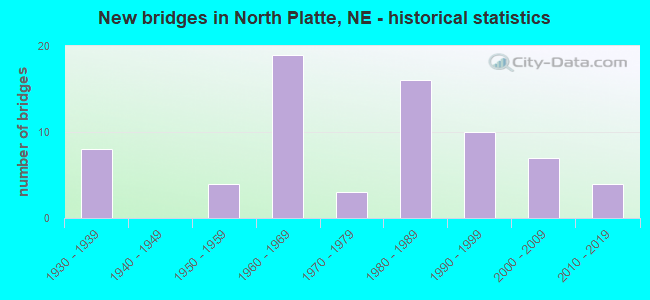
- New bridges - historical statistics
- 81930-1939
- 41950-1959
- 191960-1969
- 31970-1979
- 161980-1989
- 101990-1999
- 72000-2009
- 42010-2019
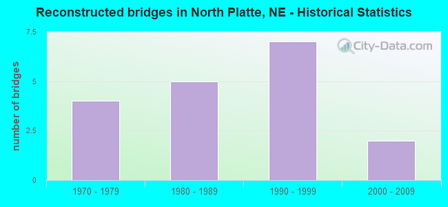
- Reconstructed bridges - Historical Statistics
- 41970-1979
- 51980-1989
- 71990-1999
- 22000-2009
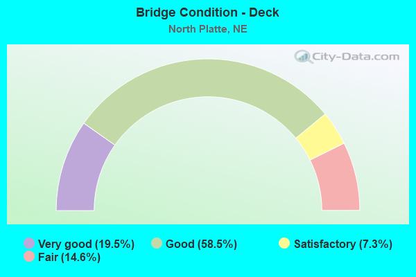
- Bridge Condition - Deck
- 19.5%Very good
- 58.5%Good
- 7.3%Satisfactory
- 14.6%Fair
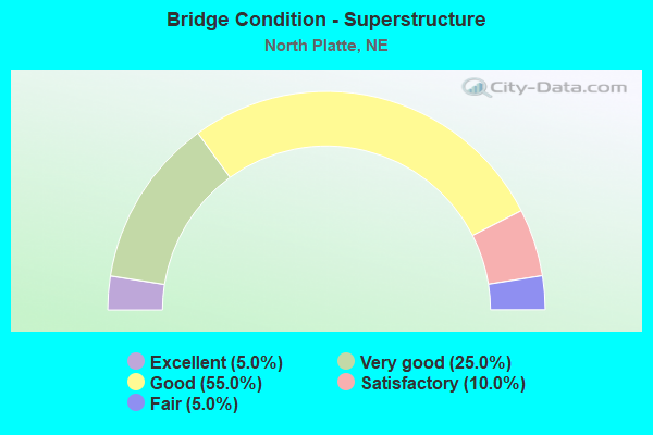
- Bridge Condition - Superstructure
- 5.0%Excellent
- 25.0%Very good
- 55.0%Good
- 10.0%Satisfactory
- 5.0%Fair
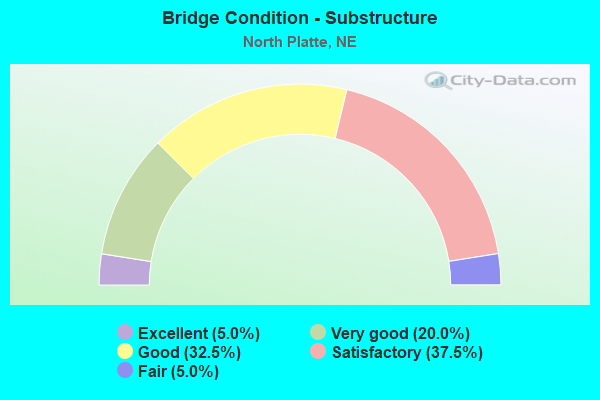
- Bridge Condition - Substructure
- 5.0%Excellent
- 20.0%Very good
- 32.5%Good
- 37.5%Satisfactory
- 5.0%Fair
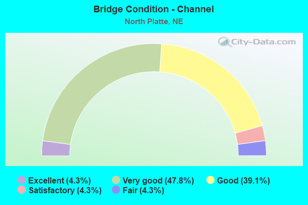
- Bridge Condition - Channel
- 4.3%Excellent
- 47.8%Very good
- 39.1%Good
- 4.3%Satisfactory
- 4.3%Fair
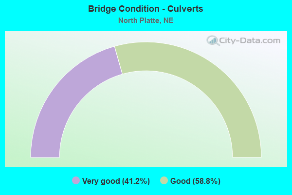
- Bridge Condition - Culverts
- 41.2%Very good
- 58.8%Good
Find on map >> Show street view
Structure Number: S083 08588, Location: 1N NORTH PLATTE (Lat: 41.173000, Lng: -100.754800), Route carried "on" structure: US 83, Year Built: 1994, Status: Open, Structure Length: 1.13m (3.71ft), Average Daily Traffic: 5,010 (year 2018), Truck Traffic: 10%, Average Future Daily Traffic: 7,014 (year 2038), Design Load: HS 20, Features Intersected: WHITE HORSE CREEK
Minimum Vertical Clearance: 30+ m (98+ ft), Kilometerpoint: 13.821, Lanes on structure: 2, Base Highway Network: Yes, Owner: State Highway Agency, Approaching Roadway Width: 12.2m (40.0ft), Skew: 3 degrees, Material/Design: Concrete, Design/Construction: Culvert, Number Of Spans In Main Unit: 4, Length of Maximum Span: 3.0m (9.8ft)
Condition: Channel: Very good, Culverts: Very good, Operating Rating: 43.0 metric tons, Method Used To Determine Operating Rating: Field evaluation and documented engineering judgment, Inventory Rating: 33.0 metric tons, Method Used To Determine Inventory Rating: Field evaluation and documented engineering judgment, Structural Evaluation: Equal to present desirable criteria, Waterway Adequacy: Superior to present desirable criteria, Approach Roadway Alignment: Equal to present desirable criteria, Designated Inspection Frequency: Every 48 months, Inspection Date: December 2019
Find on map >> Show street view
Structure Number: SL56G00048, Location: 1E NORTH PLATTE (Lat: 41.110100, Lng: -100.725500), Route carried "on" structure: Spur State highway L56G, Year Built: 1981, Status: Open, Structure Length: 22.04m (72.31ft), Average Daily Traffic: 5,885 (year 2018), Truck Traffic: 11%, Average Future Daily Traffic: 10,834 (year 2038), Features Intersected: SOUTH PLATTE RIVER
Minimum Vertical Clearance: 30+ m (98+ ft), Kilometerpoint: 0.077, Lanes on structure: 2, Owner: State Highway Agency, Approaching Roadway Width: 12.2m (40.0ft), Skew: 1 degrees, Material/Design: Prestressed concrete, Design/Construction: Stringer/Multi-beam, Number Of Spans In Main Unit: 10, Number Of Approach Spans: 2, Length of Maximum Span: 21.9m (71.9ft), Curb or Sidewalk Widths: Left: 0.2m (0.7ft), Right: 0.2m (0.7ft), Curb-To-Curb Width: 11.6m (38.1ft), Out-to-Out Width: 12.3m (40.4ft)
Condition: Deck: Very good, Superstructure: Good, Substructure: Good, Channel: Very good, Operating Rating: 69.0 metric tons, Method Used To Determine Operating Rating: Load Factor (LF), Inventory Rating: 35.0 metric tons, Method Used To Determine Inventory Rating: Load Factor (LF), Structural Evaluation: Better than present minimum criteria, Deck Geometry: Somewhat better than minimum adequacy, Waterway Adequacy: Equal to present desirable criteria, Approach Roadway Alignment: Equal to present desirable criteria, Designated Inspection Frequency: Every 24 months, Inspection Date: December 2021, Deck Structure Type: Concrete Cast-file-Place, Wearing Surface/Protective System: Wearing Surface: Bituminous, Membrane: Preformed Fabric, Deck Protection: Epoxy Coated Reinforcing
Find on map >> Show street view
Structure Number: SL56G0018, Location: 2SE NORTH PLATTE (Lat: 41.129200, Lng: -100.725900), Route carried "on" structure: Spur State highway L56G, Year Built: 1981, Status: Open, Structure Length: 0.76m (2.49ft), Average Daily Traffic: 5,885 (year 2018), Truck Traffic: 11%, Average Future Daily Traffic: 10,834 (year 2038), Features Intersected: CITY DRAINAGE DITCH
Minimum Vertical Clearance: 30+ m (98+ ft), Kilometerpoint: 0.290, Lanes on structure: 2, Owner: State Highway Agency, Approaching Roadway Width: 12.2m (40.0ft), Material/Design: Concrete, Design/Construction: Culvert, Number Of Spans In Main Unit: 3, Length of Maximum Span: 2.4m (7.9ft)
Condition: Channel: Very good, Culverts: Very good, Operating Rating: 43.0 metric tons, Method Used To Determine Operating Rating: Field evaluation and documented engineering judgment, Inventory Rating: 33.0 metric tons, Method Used To Determine Inventory Rating: Field evaluation and documented engineering judgment, Structural Evaluation: Equal to present desirable criteria, Waterway Adequacy: Equal to present desirable criteria, Approach Roadway Alignment: Equal to present desirable criteria, Designated Inspection Frequency: Every 24 months, Inspection Date: December 2021
Find on map >> Show street view
Structure Number: U177505705P, Location: JCT I80/US83 .8S 2.1E (Lat: 41.100000, Lng: -100.725000), Route carried "on" structure: City street 5829, Year Built: 1981, Year Reconstructed: 2003, Status: Open, Structure Length: 0.79m (2.59ft), Average Daily Traffic: 4,715 (year 2009), Average Future Daily Traffic: 4,715 (year 2033), Features Intersected: FREMONT SLOUGH
Minimum Vertical Clearance: 30+ m (98+ ft), Kilometerpoint: 0.100, Lanes on structure: 4, Owner: City or Municipal Highway Agency, Approaching Roadway Width: 20.7m (67.9ft), Skew: 21 degrees, Material/Design: Concrete, Design/Construction: Culvert, Number Of Spans In Main Unit: 3, Length of Maximum Span: 2.4m (7.9ft), Curb or Sidewalk Widths: Left: 1.2m (3.9ft), Right: 1.2m (3.9ft)
Condition: Channel: Very good, Culverts: Very good, Operating Rating: 33.0 metric tons, Method Used To Determine Operating Rating: Field evaluation and documented engineering judgment, Inventory Rating: 22.0 metric tons, Method Used To Determine Inventory Rating: Field evaluation and documented engineering judgment, Structural Evaluation: Somewhat better than minimum adequacy, Waterway Adequacy: Equal to present desirable criteria, Approach Roadway Alignment: Equal to present desirable criteria, Designated Inspection Frequency: Every 24 months, Inspection Date: Febuary 2022
Find on map >> Show street view
Structure Number: U177514915, Location: BUFF BILL AVE & FREMO (Lat: 41.100000, Lng: -100.791700), Route carried "on" structure: City street 5805, Year Built: 2010, Status: Open, Structure Length: 1.89m (6.20ft), Average Daily Traffic: 7,215 (year 2009), Truck Traffic: 2%, Average Future Daily Traffic: 7,500 (year 2033), Design Load: HS 25 or greater, Features Intersected: FREMONT SLOUGH, Facility Carried by Structure: BUFFALO BILL AVE
Minimum Vertical Clearance: 30+ m (98+ ft), Kilometerpoint: 0.000, Lanes on structure: 2, Owner: City or Municipal Highway Agency, Approaching Roadway Width: 12.8m (42.0ft), Material/Design: Prestressed concrete, Design/Construction: Tee Beam, Number Of Spans In Main Unit: 1, Length of Maximum Span: 18.3m (60.0ft), Curb or Sidewalk Widths: Left: 0.0m, Right: 3.2m (10.5ft), Curb-To-Curb Width: 12.8m (42.0ft), Out-to-Out Width: 16.9m (55.4ft)
Condition: Deck: Very good, Superstructure: Excellent, Substructure: Excellent, Channel: Good, Operating Rating: 57.0 metric tons, Method Used To Determine Operating Rating: Load Factor (LF), Inventory Rating: 44.0 metric tons, Method Used To Determine Inventory Rating: Load Factor (LF), Structural Evaluation: Superior to present desirable criteria, Deck Geometry: Somewhat better than minimum adequacy, Waterway Adequacy: Better than present minimum criteria, Approach Roadway Alignment: Equal to present desirable criteria, Designated Inspection Frequency: Every 24 months, Inspection Date: August 2021, Deck Structure Type: Concrete Cast-file-Place, Wearing Surface/Protective System: Wearing Surface: Monolithic Concrete, Deck Protection: Epoxy Coated Reinforcing
Find on map >> Show street view
Structure Number: U17751492, Location: BUFF BILL & SO. PLATT (Lat: 41.117200, Lng: -100.783900), Route carried "on" structure: City street 5805, Year Built: 2010, Status: Open, Structure Length: 23.35m (76.61ft), Average Daily Traffic: 7,215 (year 2009), Truck Traffic: 2%, Average Future Daily Traffic: 7,500 (year 2033), Design Load: HS 25 or greater, Features Intersected: SO. PLATTE RIVER, Facility Carried by Structure: BUFFALO BILL AVE
Minimum Vertical Clearance: 30+ m (98+ ft), Kilometerpoint: 0.000, Lanes on structure: 2, Owner: City or Municipal Highway Agency, Approaching Roadway Width: 12.8m (42.0ft), Material/Design: Prestressed concrete continuous, Design/Construction: Stringer/Multi-beam, Number Of Spans In Main Unit: 5, Length of Maximum Span: 47.5m (155.8ft), Curb or Sidewalk Widths: Left: 0.0m, Right: 3.2m (10.5ft), Curb-To-Curb Width: 12.8m (42.0ft), Out-to-Out Width: 16.9m (55.4ft)
Condition: Deck: Good, Superstructure: Very good, Substructure: Very good, Channel: Very good, Operating Rating: 47.0 metric tons, Method Used To Determine Operating Rating: Load Factor (LF), Inventory Rating: 34.0 metric tons, Method Used To Determine Inventory Rating: Load Factor (LF), Structural Evaluation: Equal to present desirable criteria, Deck Geometry: Somewhat better than minimum adequacy, Waterway Adequacy: Equal to present desirable criteria, Approach Roadway Alignment: Equal to present desirable criteria, Designated Inspection Frequency: Every 24 months, Inspection Date: August 2021, Deck Structure Type: Concrete Cast-file-Place, Wearing Surface/Protective System: Wearing Surface: Monolithic Concrete, Deck Protection: Epoxy Coated Reinforcing
Find on map >> Show street view
Structure Number: U17751571, Location: BURLINGTON BLVD @ BICENT (Lat: 41.129200, Lng: -100.734100), Route carried "on" structure: City street 5823, Year Built: 1935, Status: Posted for load, Structure Length: 0.67m (2.20ft), Average Daily Traffic: 425 (year 2013), Average Future Daily Traffic: 460 (year 2033), Features Intersected: BURLINGTON DITCH @ BICEN
Minimum Vertical Clearance: 30+ m (98+ ft), Kilometerpoint: 16.127, Lanes on structure: 2, Owner: City or Municipal Highway Agency, Approaching Roadway Width: 8.5m (27.9ft), Material/Design: Prestressed concrete, Design/Construction: Tee Beam, Number Of Spans In Main Unit: 1, Length of Maximum Span: 6.4m (21.0ft), Curb-To-Curb Width: 9.1m (29.9ft), Out-to-Out Width: 9.1m (29.9ft)
Condition: Deck: Fair, Superstructure: Good, Substructure: Good, Channel: Good, Operating Rating: 33.0 metric tons, Method Used To Determine Operating Rating: Field evaluation and documented engineering judgment, Inventory Rating: 22.0 metric tons, Method Used To Determine Inventory Rating: Field evaluation and documented engineering judgment, Structural Evaluation: Equal to present minimum criteria, Deck Geometry: Equal to present minimum criteria, Waterway Adequacy: Equal to present desirable criteria, Approach Roadway Alignment: Equal to present desirable criteria, Designated Inspection Frequency: Every 24 months, Inspection Date: Febuary 2022, Deck Structure Type: Concrete Cast-file-Place, Wearing Surface/Protective System: Wearing Surface: Bituminous
Find on map >> Show street view
Structure Number: U17752341, Location: JCT I80/US83 1.7W 3.5N (Lat: 41.162600, Lng: -100.794900), Route carried "on" structure: City street 5805, Year Built: 1991, Status: Open, Structure Length: 0.76m (2.49ft), Average Daily Traffic: 275 (year 2013), Average Future Daily Traffic: 165 (year 2033), Features Intersected: SCOUT CREEK @ SCOUT REST
Minimum Vertical Clearance: 30+ m (98+ ft), Kilometerpoint: 16.631, Lanes on structure: 2, Owner: City or Municipal Highway Agency, Approaching Roadway Width: 6.7m (22.0ft), Material/Design: Concrete, Design/Construction: Culvert, Number Of Spans In Main Unit: 3, Length of Maximum Span: 2.4m (7.9ft)
Condition: Channel: Very good, Culverts: Very good, Operating Rating: 33.0 metric tons, Method Used To Determine Operating Rating: Field evaluation and documented engineering judgment, Inventory Rating: 22.0 metric tons, Method Used To Determine Inventory Rating: Field evaluation and documented engineering judgment, Structural Evaluation: Equal to present minimum criteria, Waterway Adequacy: Better than present minimum criteria, Approach Roadway Alignment: Equal to present desirable criteria, Designated Inspection Frequency: Every 24 months, Inspection Date: Febuary 2022
Find on map >> Show street view
Structure Number: U177524415, Location: JCT I80/US83 1.5S .3E (Lat: 41.090100, Lng: -100.759500), Route carried "on" structure: City street 1480, Year Built: 1935, Status: Open, Structure Length: 4.48m (14.70ft), Average Daily Traffic: 2,450 (year 2007), Average Future Daily Traffic: 2,450 (year 2033), Features Intersected: NPPD TAILRACE CANAL
Minimum Vertical Clearance: 30+ m (98+ ft), Kilometerpoint: 0.578, Lanes on structure: 2, Owner: City or Municipal Highway Agency, Approaching Roadway Width: 9.1m (29.9ft), Material/Design: Concrete continuous, Design/Construction: Frame, Number Of Spans In Main Unit: 3, Length of Maximum Span: 21.9m (71.9ft), Curb or Sidewalk Widths: Left: 0.1m (0.3ft), Right: 0.1m (0.3ft), Curb-To-Curb Width: 7.3m (24.0ft), Out-to-Out Width: 8.2m (26.9ft)
Condition: Deck: Satisfactory, Superstructure: Satisfactory, Substructure: Satisfactory, Channel: Good, Operating Rating: 33.0 metric tons, Method Used To Determine Operating Rating: Field evaluation and documented engineering judgment, Inventory Rating: 22.0 metric tons, Method Used To Determine Inventory Rating: Field evaluation and documented engineering judgment, Structural Evaluation: Somewhat better than minimum adequacy, Deck Geometry: High priority of replacement, Waterway Adequacy: Superior to present desirable criteria, Approach Roadway Alignment: Equal to present desirable criteria, Length Of Structure Improvement: 4.48m (14.70ft), Designated Inspection Frequency: Every 24 months, Underwater Inspection Frequency: Every 60 months, Inspection Date: Febuary 2022, Underwater Inspection Date: August 2018, Deck Structure Type: Concrete Cast-file-Place, Wearing Surface/Protective System: Wearing Surface: Monolithic Concrete
Find on map >> Show street view
Structure Number: U17752512, Location: N PLATTE BUFFALO BILL AVE (Lat: 41.143900, Lng: -100.791500), Route carried "on" structure: City street 5805, Year Built: 1989, Status: Open, Structure Length: 43.40m (142.39ft), Average Daily Traffic: 8,000 (year 2013), Average Future Daily Traffic: 7,215 (year 2033), Features Intersected: FRNT ST/UPRR 816-151-W, Facility Carried by Structure: BUFFALO BILL AVE
Minimum Vertical Clearance: 30+ m (98+ ft), Kilometerpoint: 16.390, Lanes on structure: 2, Lanes under structure: 6, Owner: City or Municipal Highway Agency, Approaching Roadway Width: 13.1m (43.0ft), Material/Design: Steel continuous, Design/Construction: Stringer/Multi-beam, Number Of Spans In Main Unit: 11, Length of Maximum Span: 65.5m (214.9ft), Curb or Sidewalk Widths: Left: 1.9m (6.2ft), Right: 0.2m (0.7ft), Curb-To-Curb Width: 9.1m (29.9ft), Out-to-Out Width: 11.7m (38.4ft)
Condition: Deck: Good, Superstructure: Very good, Substructure: Satisfactory, Operating Rating: 35.0 metric tons, Method Used To Determine Operating Rating: Load Factor (LF), Inventory Rating: 21.0 metric tons, Method Used To Determine Inventory Rating: Load Factor (LF), Structural Evaluation: Somewhat better than minimum adequacy, Deck Geometry: Meets minimum limits, Underclear: Meets minimum limits, Approach Roadway Alignment: Equal to present desirable criteria, Length Of Structure Improvement: 43.40m (142.39ft), Designated Inspection Frequency: Every 24 months, Inspection Date: Febuary 2022, Deck Structure Type: Other, Wearing Surface/Protective System: Wearing Surface: Monolithic Concrete, Deck Protection: Epoxy Coated Reinforcing
Find on map >> Show street view
Structure Number: U17752513, Location: JCT I80/US83 1.5W 3.4N (Lat: 41.162200, Lng: -100.791500), Route carried "on" structure: City street 5805, Year Built: 1991, Year Reconstructed: 1998, Status: Open, Structure Length: 0.76m (2.49ft), Average Daily Traffic: 275 (year 2013), Average Future Daily Traffic: 165 (year 2033), Features Intersected: SCOUT CRK @ BUFFALO BILL
Minimum Vertical Clearance: 30+ m (98+ ft), Kilometerpoint: 16.597, Lanes on structure: 3, Owner: City or Municipal Highway Agency, Approaching Roadway Width: 12.8m (42.0ft), Material/Design: Concrete, Design/Construction: Culvert, Number Of Spans In Main Unit: 3, Length of Maximum Span: 2.4m (7.9ft), Curb or Sidewalk Widths: Left: 1.2m (3.9ft), Right: 3.0m (9.8ft)
Condition: Channel: Very good, Culverts: Very good, Operating Rating: 33.0 metric tons, Method Used To Determine Operating Rating: Field evaluation and documented engineering judgment, Inventory Rating: 22.0 metric tons, Method Used To Determine Inventory Rating: Field evaluation and documented engineering judgment, Structural Evaluation: Equal to present minimum criteria, Waterway Adequacy: Better than present minimum criteria, Approach Roadway Alignment: Equal to present desirable criteria, Designated Inspection Frequency: Every 24 months, Inspection Date: Febuary 2022
Find on map >> Show street view
Structure Number: U177525305P, Location: .5S NORTH PLATTE (Lat: 41.098300, Lng: -100.768300), Route carried "on" structure: City street P253, Year Built: 1958, Status: Open, Structure Length: 0.98m (3.22ft), Average Daily Traffic: 250 (year 2003), Truck Traffic: 10%, Average Future Daily Traffic: 362 (year 2033), Features Intersected: FREMONT SLOUGH, Facility Carried by Structure: COUNTY HIGHWAY
Minimum Vertical Clearance: 30+ m (98+ ft), Kilometerpoint: 0.000, Lanes on structure: 2, Owner: City or Municipal Highway Agency, Approaching Roadway Width: 6.7m (22.0ft), Material/Design: Steel, Design/Construction: Stringer/Multi-beam, Number Of Spans In Main Unit: 1, Length of Maximum Span: 9.1m (29.9ft), Curb-To-Curb Width: 10.4m (34.1ft), Out-to-Out Width: 11.6m (38.1ft)
Condition: Deck: Fair, Superstructure: Good, Substructure: Fair, Channel: Good, Operating Rating: 42.0 metric tons, Method Used To Determine Operating Rating: Load Factor (LF), Inventory Rating: 25.0 metric tons, Method Used To Determine Inventory Rating: Load Factor (LF), Structural Evaluation: Somewhat better than minimum adequacy, Deck Geometry: Better than present minimum criteria, Waterway Adequacy: Equal to present minimum criteria, Approach Roadway Alignment: Equal to present desirable criteria, Length Of Structure Improvement: 0.98m (3.22ft), Designated Inspection Frequency: Every 24 months, Inspection Date: August 2021, Deck Structure Type: Other, Wearing Surface/Protective System: Wearing Surface: Bituminous
Find on map >> Show street view
Structure Number: U17752651, Location: JCT I80/US83 .5S .5E (Lat: 41.104400, Lng: -100.753900), Route carried "on" structure: City street 5802, Year Built: 2009, Status: Open, Structure Length: 4.66m (15.29ft), Average Daily Traffic: 500 (year 2009), Average Future Daily Traffic: 550 (year 2033), Design Load: HS 20, Features Intersected: NPPD TAILRACE CANAL
Minimum Vertical Clearance: 30+ m (98+ ft), Kilometerpoint: 0.322, Lanes on structure: 2, Owner: City or Municipal Highway Agency, Approaching Roadway Width: 11.3m (37.1ft), Material/Design: Prestressed concrete, Design/Construction: Tee Beam, Number Of Spans In Main Unit: 3, Length of Maximum Span: 15.5m (50.9ft), Curb-To-Curb Width: 11.3m (37.1ft), Out-to-Out Width: 15.4m (50.5ft)
Condition: Deck: Good, Superstructure: Very good, Substructure: Good, Channel: Good, Operating Rating: 52.0 metric tons, Method Used To Determine Operating Rating: Load Factor (LF), Inventory Rating: 33.0 metric tons, Method Used To Determine Inventory Rating: Load Factor (LF), Structural Evaluation: Better than present minimum criteria, Deck Geometry: Better than present minimum criteria, Waterway Adequacy: Superior to present desirable criteria, Approach Roadway Alignment: Equal to present desirable criteria, Designated Inspection Frequency: Every 24 months, Underwater Inspection Frequency: Every 60 months, Inspection Date: August 2021, Underwater Inspection Date: August 2018, Deck Structure Type: Concrete Cast-file-Place, Wearing Surface/Protective System: Wearing Surface: Monolithic Concrete, Deck Protection: Epoxy Coated Reinforcing
Find on map >> Show street view
Structure Number: U1775A5305, Location: NORTH PLATTE WILLOW@FRONT (Lat: 41.140400, Lng: -100.766200), Route carried "on" structure: City street 5817, Year Built: 1981, Status: Open, Structure Length: 34.75m (114.01ft), Average Daily Traffic: 4,060 (year 2013), Average Future Daily Traffic: 6,465 (year 2033), Features Intersected: FRONT ST/UPRR 817-970-R
Minimum Vertical Clearance: 30+ m (98+ ft), Kilometerpoint: 16.312, Lanes on structure: 2, Lanes under structure: 6, Owner: City or Municipal Highway Agency, Approaching Roadway Width: 9.1m (29.9ft), Material/Design: Steel continuous, Design/Construction: Stringer/Multi-beam, Number Of Spans In Main Unit: 16, Length of Maximum Span: 25.9m (85.0ft), Curb or Sidewalk Widths: Left: 1.9m (6.2ft), Right: 0.0m, Curb-To-Curb Width: 9.1m (29.9ft), Out-to-Out Width: 11.7m (38.4ft)
Condition: Deck: Good, Superstructure: Good, Substructure: Satisfactory, Operating Rating: 68.0 metric tons, Method Used To Determine Operating Rating: Load Factor (LF), Inventory Rating: 41.0 metric tons, Method Used To Determine Inventory Rating: Load Factor (LF), Structural Evaluation: Equal to present minimum criteria, Deck Geometry: Meets minimum limits, Underclear: Meets minimum limits, Approach Roadway Alignment: Equal to present desirable criteria, Length Of Structure Improvement: 34.75m (114.01ft), Designated Inspection Frequency: Every 24 months, Inspection Date: Febuary 2022, Deck Structure Type: Other, Wearing Surface/Protective System: Wearing Surface: Monolithic Concrete, Deck Protection: Epoxy Coated Reinforcing
Find on map >> Show street view
Structure Number: U1775D4005, Location: SE CL NORTH PLATTE (Lat: 41.111700, Lng: -100.753300), Route carried "on" structure: City street D40, Year Built: 1964, Year Reconstructed: 1976, Status: Open, Structure Length: 4.63m (15.19ft), Average Daily Traffic: 1,000 (year 2003), Truck Traffic: 10%, Average Future Daily Traffic: 1,450 (year 2033), Design Load: H 20, Features Intersected: NPPD POWER CANAL, Facility Carried by Structure: TECH COLLEGE ROAD
Minimum Vertical Clearance: 30+ m (98+ ft), Kilometerpoint: 0.000, Lanes on structure: 2, Owner: City or Municipal Highway Agency, Approaching Roadway Width: 7.3m (24.0ft), Material/Design: Prestressed concrete, Design/Construction: Stringer/Multi-beam, Number Of Spans In Main Unit: 3, Length of Maximum Span: 15.2m (49.9ft), Curb-To-Curb Width: 9.1m (29.9ft), Out-to-Out Width: 10.2m (33.5ft)
Condition: Deck: Fair, Superstructure: Good, Substructure: Satisfactory, Channel: Good, Operating Rating: 33.0 metric tons, Method Used To Determine Operating Rating: Field evaluation and documented engineering judgment, Inventory Rating: 22.0 metric tons, Method Used To Determine Inventory Rating: Field evaluation and documented engineering judgment, Structural Evaluation: Somewhat better than minimum adequacy, Deck Geometry: Equal to present minimum criteria, Waterway Adequacy: Superior to present desirable criteria, Approach Roadway Alignment: Equal to present minimum criteria, Length Of Structure Improvement: 4.63m (15.19ft), Designated Inspection Frequency: Every 24 months, Underwater Inspection Frequency: Every 60 months, Inspection Date: August 2021, Underwater Inspection Date: August 2018, Deck Structure Type: Concrete Cast-file-Place, Wearing Surface/Protective System: Wearing Surface: Monolithic Concrete
Find on map >> Show street view
Structure Number: U1775J5315, Location: N PLATTE POPLAR AVE@UPRR (Lat: 41.133300, Lng: -100.750000), Route carried "on" structure: City street 5819, Year Built: 2001, Status: Open, Structure Length: 19.48m (63.91ft), Average Daily Traffic: 500 (year 1997), Average Future Daily Traffic: 600 (year 2033), Design Load: HS 20, Features Intersected: FRNT ST/UPRR 816-151-W
Minimum Vertical Clearance: 30+ m (98+ ft), Kilometerpoint: 0.035, Lanes on structure: 2, Lanes under structure: 2, Owner: City or Municipal Highway Agency, Approaching Roadway Width: 13.1m (43.0ft), Material/Design: Steel continuous, Design/Construction: Stringer/Multi-beam, Number Of Spans In Main Unit: 5, Length of Maximum Span: 56.4m (185.0ft), Curb or Sidewalk Widths: Left: 1.5m (4.9ft), Right: 0.0m, Curb-To-Curb Width: 10.5m (34.4ft), Out-to-Out Width: 13.0m (42.7ft)
Condition: Deck: Good, Superstructure: Very good, Substructure: Very good, Operating Rating: 57.0 metric tons, Method Used To Determine Operating Rating: Load Factor (LF), Inventory Rating: 34.0 metric tons, Method Used To Determine Inventory Rating: Load Factor (LF), Structural Evaluation: Equal to present desirable criteria, Deck Geometry: Equal to present minimum criteria, Underclear: Equal to present minimum criteria, Approach Roadway Alignment: Equal to present desirable criteria, Designated Inspection Frequency: Every 24 months, Inspection Date: August 2021, Deck Structure Type: Concrete Cast-file-Place, Wearing Surface/Protective System: Wearing Surface: Monolithic Concrete, Deck Protection: Epoxy Coated Reinforcing
Find on map >> Show street view
Structure Number: S080 17372, Location: 4W NORTH PLATTE S INTRCHG (Lat: 41.114400, Lng: -100.829700), Route carried "under" structure: Interstate 80, Year Built: 1966, Structure Length: 0. m, Average Daily Traffic: 15,305 (year 2013), Truck Traffic: 42%, Features Intersected: I80, Facility Carried by Structure: COUNTY HIGHWAY
Minimum Vertical Clearance: 5.02m (16.47ft), Kilometerpoint: 27.958, Lanes on structure: 4, Lanes under structure: 4, Material/Design: Prestressed concrete, Design/Construction: Stringer/Multi-beam, Length of Maximum Span: 21.6m (70.9ft)
Find on map >> Show street view
Structure Number: S080 17567, Location: I80 & BUFFALO BILL AV (Lat: 41.112500, Lng: -100.792500), Route carried "under" structure: Interstate 80, Year Built: 2010, Structure Length: 0. m, Average Daily Traffic: 7,500 (year 2003), Truck Traffic: 5%, Features Intersected: I80, Facility Carried by Structure: BUFFALO BILL AVE
Minimum Vertical Clearance: 5.11m (16.77ft), Kilometerpoint: 28.268, Lanes on structure: 2, Lanes under structure: 4, Material/Design: Prestressed concrete continuous, Design/Construction: Stringer/Multi-beam, Length of Maximum Span: 44.2m (145.0ft)
Find on map >> Show street view
Structure Number: S080 17718, Location: NORTH PLATTE S INTRCHG (Lat: 41.111200, Lng: -100.764000), Route carried "under" structure: Interstate 80, Year Built: 1995, Structure Length: 0. m, Average Daily Traffic: 15,190 (year 2013), Truck Traffic: 43%, Features Intersected: I80, Facility Carried by Structure: SB-US83
Minimum Vertical Clearance: 4.97m (16.31ft), Kilometerpoint: 28.514, Lanes on structure: 4, Lanes under structure: 4, Material/Design: Prestressed concrete, Design/Construction: Stringer/Multi-beam, Length of Maximum Span: 43.6m (143.0ft)
Find on map >> Show street view
Structure Number: S080 17719, Location: NORTH PLATTE S INTRCHG (Lat: 41.111200, Lng: -100.763800), Route carried "under" structure: Interstate 80, Year Built: 1995, Structure Length: 0. m, Average Daily Traffic: 15,190 (year 2013), Truck Traffic: 43%, Features Intersected: I80, Facility Carried by Structure: NB-US83
Minimum Vertical Clearance: 5.03m (16.50ft), Kilometerpoint: 28.516, Lanes on structure: 4, Lanes under structure: 4, Material/Design: Prestressed concrete, Design/Construction: Stringer/Multi-beam, Length of Maximum Span: 43.6m (143.0ft)
Find on map >> Show street view
Structure Number: S080 17922, Location: NORTH PLATTE E INTRCHG (Lat: 41.105000, Lng: -100.726000), Route carried "under" structure: Interstate 80, Year Built: 1983, Structure Length: 0. m, Average Daily Traffic: 14,920 (year 2013), Truck Traffic: 44%, Features Intersected: I80, Facility Carried by Structure: L56G-NORTH PLATTE
Minimum Vertical Clearance: 5.22m (17.13ft), Kilometerpoint: 28.843, Lanes on structure: 4, Lanes under structure: 4, Material/Design: Prestressed concrete, Design/Construction: Stringer/Multi-beam, Length of Maximum Span: 22.6m (74.1ft)
Find on map >> Show street view
Structure Number: S080 17975, Location: 1E NORTH PLATTE E INTRCHG (Lat: 41.103400, Lng: -100.715700), Route carried "under" structure: Interstate 80, Year Built: 1966, Structure Length: 0. m, Average Daily Traffic: 14,920 (year 2013), Truck Traffic: 44%, Features Intersected: I80, Facility Carried by Structure: COUNTY HIGHWAY
Minimum Vertical Clearance: 4.94m (16.21ft), Kilometerpoint: 28.928, Lanes on structure: 4, Lanes under structure: 4, Material/Design: Prestressed concrete continuous, Design/Construction: Stringer/Multi-beam, Length of Maximum Span: 21.9m (71.9ft)
Find on map >> Show street view
Structure Number: S083 08355, Location: IN NORTH PLATTE (Lat: 41.139500, Lng: -100.762600), Route carried "under" structure: City street 5814, Year Built: 1936, Structure Length: 0. m, Average Daily Traffic: 875 (year 2013), Truck Traffic: 2%, Features Intersected: FRONT STREET, Facility Carried by Structure: US83
Minimum Vertical Clearance: 6.90m (22.64ft), Kilometerpoint: 16.522, Lanes on structure: 2, Lanes under structure: 2, Material/Design: Steel continuous, Design/Construction: Stringer/Multi-beam, Length of Maximum Span: 25.6m (84.0ft)
Find on map >> Show street view
Structure Number: U17752512, Location: N PLATTE BUFFALO BILL AVE (Lat: 41.143900, Lng: -100.791500), Route carried "under" structure: City street P1360, Year Built: 1989, Structure Length: 0. m, Average Daily Traffic: 3,890 (year 2007), Features Intersected: FRNT ST/UPRR 816-151-W, Facility Carried by Structure: BUFFALO BILL AVE
Minimum Vertical Clearance: 5.08m (16.67ft), Kilometerpoint: 0.000, Lanes on structure: 6, Lanes under structure: 6, Material/Design: Steel continuous, Design/Construction: Stringer/Multi-beam, Length of Maximum Span: 65.5m (214.9ft)
Find on map >> Show street view
Structure Number: U17752512, Location: N PLATTE BUFFALO BILL AVE (Lat: 41.143900, Lng: -100.791500), Route carried "under" structure: City street P360, Year Built: 1989, Structure Length: 0. m, Average Daily Traffic: 3,890 (year 2007), Features Intersected: FRNT ST/UPRR 816-151-W, Facility Carried by Structure: BUFFALO BILL AVE
Minimum Vertical Clearance: 7.08m (23.23ft), Kilometerpoint: 0.000, Lanes on structure: 6, Lanes under structure: 6, Material/Design: Steel continuous, Design/Construction: Stringer/Multi-beam, Length of Maximum Span: 65.5m (214.9ft)
Find on map >> Show street view
Structure Number: U17752512, Location: N PLATTE BUFFALO BILL AVE (Lat: 41.143900, Lng: -100.791500), Route carried "under" structure: City street 5814, Year Built: 1989, Structure Length: 0. m, Average Daily Traffic: 3,890 (year 2007), Features Intersected: FRNT ST/UPRR 816-151-W, Facility Carried by Structure: BUFFALO BILL AVE
Minimum Vertical Clearance: 8.22m (26.97ft), Kilometerpoint: 0.000, Lanes on structure: 6, Lanes under structure: 6, Material/Design: Steel continuous, Design/Construction: Stringer/Multi-beam, Length of Maximum Span: 65.5m (214.9ft)
Find on map >> Show street view
Structure Number: U1775A5305, Location: NORTH PLATTE WILLOW@FRONT (Lat: 41.140400, Lng: -100.766200), Route carried "under" structure: City street 5814, Year Built: 1981, Structure Length: 0. m, Average Daily Traffic: 3,960 (year 2007), Features Intersected: FRONT ST/UPRR 817-970-R, Facility Carried by Structure: WILLOW ST/FAU 5817
Minimum Vertical Clearance: 7.77m (25.49ft), Kilometerpoint: 0.000, Lanes on structure: 6, Lanes under structure: 6, Material/Design: Steel continuous, Design/Construction: Stringer/Multi-beam, Length of Maximum Span: 25.9m (85.0ft)
Find on map >> Show street view
Structure Number: U1775A5305, Location: NORTH PLATTE WILLOW@FRONT (Lat: 41.140400, Lng: -100.766200), Route carried "under" structure: City street P53, Year Built: 1981, Structure Length: 0. m, Average Daily Traffic: 3,960 (year 2007), Features Intersected: FRONT ST/UPRR 817-970-R, Facility Carried by Structure: WILLOW ST/FAU 5817
Minimum Vertical Clearance: 8.05m (26.41ft), Kilometerpoint: 0.000, Lanes on structure: 6, Lanes under structure: 6, Material/Design: Steel continuous, Design/Construction: Stringer/Multi-beam, Length of Maximum Span: 25.9m (85.0ft)
Find on map >> Show street view
Structure Number: U1775A5305, Location: NORTH PLATTE WILLOW@FRONT (Lat: 41.140400, Lng: -100.766200), Route carried "under" structure: City street P53, Year Built: 1981, Structure Length: 0. m, Average Daily Traffic: 3,960 (year 2007), Features Intersected: FRONT ST/UPRR 817-970-R, Facility Carried by Structure: WILLOW ST/FAU 5817
Minimum Vertical Clearance: 4.57m (14.99ft), Kilometerpoint: 0.000, Lanes on structure: 6, Lanes under structure: 6, Material/Design: Steel continuous, Design/Construction: Stringer/Multi-beam, Length of Maximum Span: 25.9m (85.0ft)