Bridge Statistics for North Washington, Colorado (CO)
Condition, Traffic, Stress, Structural Evaluation, Project Costs
- National Bridge Inventory (NBI) Statistics
- 66Number of bridges
- 1,119ft / 341mTotal length
- $4,245,000Total costs
- 4,503,365Total average daily traffic
- 491,839Total average daily truck traffic
- National Bridge Inventory (NBI) Registered Bridges for North Washington
- No street view available for this location
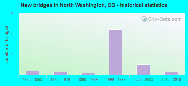
- New bridges - historical statistics
- 41960-1969
- 31970-1979
- 21980-1989
- 441990-1999
- 102000-2009
- 32010-2019


- Bridge Condition - Deck
- 56.4%Good
- 33.3%Satisfactory
- 2.6%Fair
- 7.7%Poor

- Bridge Condition - Superstructure
- 17.9%Very good
- 51.3%Good
- 25.6%Satisfactory
- 5.1%Fair

- Bridge Condition - Substructure
- 17.9%Very good
- 53.8%Good
- 17.9%Satisfactory
- 7.7%Fair
- 2.6%Poor

- Bridge Condition - Channel
- 66.7%Very good
- 8.3%Good
- 16.7%Satisfactory
- 8.3%Fair
Find on map >> Show street view
Structure Number: E-17-QY, Location: .2 MI S. OF I76 & BRO (Lat: 39.812492, Lng: -104.987592), Route carried "on" structure: State highway 53A, Year Built: 1993, Status: Open, Structure Length: 0.90m (2.95ft), Average Daily Traffic: 14,000 (year 2018), Truck Traffic: 9%, Average Future Daily Traffic: 15,820 (year 2038), Design Load: HS 20, Features Intersected: 64TH ST DRAIN CANAL, Facility Carried by Structure: SH 53 ML
Minimum Vertical Clearance: 30+ m (98+ ft), Kilometerpoint: 1.551, Lanes on structure: 2, Owner: State Highway Agency, Approaching Roadway Width: 10.4m (34.1ft), Skew: 4 degrees, Material/Design: Concrete, Design/Construction: Culvert, Number Of Spans In Main Unit: 2, Length of Maximum Span: 4.3m (14.1ft), Out-to-Out Width: 146.3m (480.0ft)
Condition: Channel: Very good, Culverts: Good, Operating Rating: 36.3 metric tons, Method Used To Determine Operating Rating: Field evaluation and documented engineering judgment, Inventory Rating: 32.7 metric tons, Method Used To Determine Inventory Rating: Field evaluation and documented engineering judgment, Structural Evaluation: Better than present minimum criteria, Waterway Adequacy: Equal to present desirable criteria, Approach Roadway Alignment: Equal to present desirable criteria, Designated Inspection Frequency: Every 48 months, Inspection Date: June 2019
Find on map >> Show street view
Structure Number: E-17-VS, Location: I-25NB to SH224 70th Ave (Lat: 39.820861, Lng: -104.982250), Route carried "on" structure: Ramp State highway 224A, Year Built: 1998, Status: Open, Structure Length: 9.21m (30.22ft), Average Daily Traffic: 10,000 (year 2020), Truck Traffic: 5%, Average Future Daily Traffic: 11,700 (year 2040), Design Load: HS 25 or greater, Features Intersected: CLEAR CREEK R, Facility Carried by Structure: I25 NBND TO SH224
Minimum Vertical Clearance: 30+ m (98+ ft), Kilometerpoint: 0.090, Lanes on structure: 1, Owner: State Highway Agency, Approaching Roadway Width: 8.5m (27.9ft), Skew: 4 degrees, Material/Design: Prestressed concrete, Design/Construction: Box Beam or Girders - Single/Spread, Number Of Spans In Main Unit: 3, Length of Maximum Span: 31.0m (101.7ft), Curb-To-Curb Width: 7.8m (25.6ft), Out-to-Out Width: 8.7m (28.5ft)
Condition: Deck: Good, Superstructure: Very good, Substructure: Very good, Channel: Very good, Operating Rating: 67.0 metric tons, Method Used To Determine Operating Rating: Load Factor (LF), Inventory Rating: 40.2 metric tons, Method Used To Determine Inventory Rating: Load Factor (LF), Structural Evaluation: Equal to present desirable criteria, Deck Geometry: Better than present minimum criteria, Waterway Adequacy: Equal to present desirable criteria, Approach Roadway Alignment: Equal to present desirable criteria, Designated Inspection Frequency: Every 24 months, Inspection Date: June 2021, Deck Structure Type: Concrete Cast-file-Place, Wearing Surface/Protective System: Wearing Surface: Monolithic Concrete, Deck Protection: Epoxy Coated Reinforcing
Find on map >> Show street view
Structure Number: E-17-IC, Location: IN COMMERCE CITY (Lat: 39.819458, Lng: -104.959142), Route carried "under" structure: Interstate 270A, Year Built: 1970, Structure Length: 0. m, Average Daily Traffic: 11,975 (year 2016), Truck Traffic: 14%, Features Intersected: I 270 ML, Facility Carried by Structure: YORK STREET
Minimum Vertical Clearance: 5.46m (17.91ft), Kilometerpoint: 2.089, Lanes on structure: 3, Lanes under structure: 6, Material/Design: Steel continuous, Design/Construction: Stringer/Multi-beam, Length of Maximum Span: 43.0m (141.1ft)
Find on map >> Show street view
Structure Number: E-17-NX, Location: NW OF I76 and I25 INT (Lat: 39.819536, Lng: -104.983797), Route carried "under" structure: Interstate 25A, Year Built: 1992, Structure Length: 0. m, Average Daily Traffic: 219,000 (year 2011), Truck Traffic: 10%, Features Intersected: RAMP, CLEAR CREEK R, Facility Carried by Structure: RAMP TO I 76 WBND
Minimum Vertical Clearance: 6.00m (19.69ft), Kilometerpoint: 349.000, Lanes on structure: 1, Lanes under structure: 2, Material/Design: Steel continuous, Design/Construction: Box Beam or Girders - Single/Spread, Length of Maximum Span: 61.0m (200.1ft)
Find on map >> Show street view
Structure Number: E-17-NZ, Location: I25 & I76 JCT (Lat: 39.817900, Lng: -104.983758), Route carried "under" structure: Interstate 25A, Year Built: 1991, Structure Length: 0. m, Average Daily Traffic: 235,000 (year 2011), Truck Traffic: 10%, Features Intersected: I 25 ML R, Facility Carried by Structure: RAMP TO I 76 WBND
Minimum Vertical Clearance: 6.40m (21.00ft), Kilometerpoint: 348.204, Lanes on structure: 2, Lanes under structure: 13, Material/Design: Steel continuous, Design/Construction: Box Beam or Girders - Single/Spread, Length of Maximum Span: 68.6m (225.1ft)
Find on map >> Show street view
Structure Number: E-17-OA, Location: 0.1 MI W. OF I25+I76 JCT (Lat: 39.815847, Lng: -104.985658), Route carried "under" structure: Ramp Interstate 25A, Year Built: 1991, Structure Length: 0. m, Average Daily Traffic: 196,700 (year 2005), Truck Traffic: 10%, Features Intersected: RAMP TO I 25 SBND, Facility Carried by Structure: I 76 ML EBND
Minimum Vertical Clearance: 7.00m (22.97ft), Kilometerpoint: 348.000, Lanes on structure: 2, Lanes under structure: 1, Material/Design: Prestressed concrete, Design/Construction: Stringer/Multi-beam, Length of Maximum Span: 42.4m (139.1ft)
Find on map >> Show street view
Structure Number: E-17-OB, Location: 0.1 MI W. OF I25+I76 JCT (Lat: 39.816111, Lng: -104.985664), Route carried "under" structure: Ramp Interstate 25A, Year Built: 1991, Structure Length: 0. m, Average Daily Traffic: 196,700 (year 2005), Truck Traffic: 10%, Features Intersected: RAMP TO I 25 SBND, Facility Carried by Structure: I 76 ML WBND
Minimum Vertical Clearance: 5.00m (16.40ft), Kilometerpoint: 348.000, Lanes on structure: 2, Lanes under structure: 1, Material/Design: Prestressed concrete, Design/Construction: Stringer/Multi-beam, Length of Maximum Span: 42.4m (139.1ft)
Find on map >> Show street view
Structure Number: E-17-OC, Location: I 76 AND I 25 (Lat: 39.816986, Lng: -104.983733), Route carried "under" structure: Interstate 25A, Year Built: 1990, Structure Length: 0. m, Average Daily Traffic: 235,000 (year 2011), Truck Traffic: 10%, Features Intersected: I 25 ML, Facility Carried by Structure: I 76 ML EBND
Minimum Vertical Clearance: 6.02m (19.75ft), Kilometerpoint: 348.107, Lanes on structure: 2, Lanes under structure: 13, Material/Design: Steel continuous, Design/Construction: Box Beam or Girders - Single/Spread, Length of Maximum Span: 70.7m (232.0ft)
Find on map >> Show street view
Structure Number: E-17-OD, Location: I 76 AND I 25 (Lat: 39.817283, Lng: -104.983742), Route carried "under" structure: Interstate 25A, Year Built: 1990, Structure Length: 0. m, Average Daily Traffic: 235,000 (year 2011), Truck Traffic: 10%, Features Intersected: I 25 ML, Facility Carried by Structure: I 76 ML WBND
Minimum Vertical Clearance: 5.84m (19.16ft), Kilometerpoint: 348.123, Lanes on structure: 2, Lanes under structure: 14, Material/Design: Steel continuous, Design/Construction: Box Beam or Girders - Single/Spread, Length of Maximum Span: 70.7m (232.0ft)
Find on map >> Show street view
Structure Number: E-17-OE, Location: 0.1 MI E. OF I25+I76 JCT (Lat: 39.819367, Lng: -104.980622), Route carried "under" structure: Ramp Interstate 25A, Year Built: 1991, Structure Length: 0. m, Average Daily Traffic: 237,900 (year 2005), Truck Traffic: 11%, Features Intersected: RAMP TO I 25 NBND R, Facility Carried by Structure: I76 WB OFF RAMP
Minimum Vertical Clearance: 7.00m (22.97ft), Kilometerpoint: 348.000, Lanes on structure: 1, Lanes under structure: 1, Material/Design: Prestressed concrete, Design/Construction: Stringer/Multi-beam, Length of Maximum Span: 42.4m (139.1ft)
Find on map >> Show street view
Structure Number: E-17-OF, Location: 0.2 MI E OF I 25 (Lat: 39.818778, Lng: -104.980703), Route carried "under" structure: Ramp Interstate 25A, Year Built: 1990, Structure Length: 0. m, Average Daily Traffic: 23,790 (year 2005), Truck Traffic: 11%, Features Intersected: RAMP TO I 25 NBND, Facility Carried by Structure: I 76 EBND ML
Minimum Vertical Clearance: 5.00m (16.40ft), Kilometerpoint: 348.000, Lanes on structure: 2, Lanes under structure: 1, Material/Design: Prestressed concrete, Design/Construction: Stringer/Multi-beam, Length of Maximum Span: 42.0m (137.8ft)
Find on map >> Show street view
Structure Number: E-17-OG, Location: 0.2 MI E OF I 25 (Lat: 39.819097, Lng: -104.980647), Route carried "under" structure: Ramp Interstate 25A, Year Built: 1990, Structure Length: 0. m, Average Daily Traffic: 23,790 (year 2005), Truck Traffic: 11%, Features Intersected: RAMP TO I 25 NBND, Facility Carried by Structure: I 76 WBND ML
Minimum Vertical Clearance: 6.00m (19.69ft), Kilometerpoint: 348.000, Lanes on structure: 2, Lanes under structure: 1, Material/Design: Prestressed concrete, Design/Construction: Stringer/Multi-beam, Length of Maximum Span: 42.4m (139.1ft)
Find on map >> Show street view
Structure Number: E-17-OH, Location: I25 & I76 JCT (Lat: 39.816442, Lng: -104.983733), Route carried "under" structure: Ramp Interstate 25A, Year Built: 1991, Structure Length: 0. m, Average Daily Traffic: 196,700 (year 2005), Truck Traffic: 10%, Features Intersected: I 25 ML, HOV, RAMP, Facility Carried by Structure: RAMP TO I 25 NBND
Minimum Vertical Clearance: 5.72m (18.77ft), Kilometerpoint: 348.059, Lanes on structure: 1, Lanes under structure: 14, Material/Design: Steel continuous, Design/Construction: Box Beam or Girders - Single/Spread, Length of Maximum Span: 67.7m (222.1ft)
Find on map >> Show street view
Structure Number: E-17-OI, Location: 0.1 MI W. OF I25+I76 JCT (Lat: 39.815697, Lng: -104.985292), Route carried "under" structure: Ramp Interstate 25A, Year Built: 1991, Structure Length: 0. m, Average Daily Traffic: 196,700 (year 2005), Truck Traffic: 10%, Features Intersected: RAMP TO I 25 SBND R, Facility Carried by Structure: RAMP TO I 25 NBND
Minimum Vertical Clearance: 7.00m (22.97ft), Kilometerpoint: 348.000, Lanes on structure: 1, Lanes under structure: 1, Material/Design: Prestressed concrete, Design/Construction: Stringer/Multi-beam, Length of Maximum Span: 42.4m (139.1ft)
Find on map >> Show street view
Structure Number: E-17-OK, Location: .4 MI W OF JCT I76 & (Lat: 39.814400, Lng: -104.987817), Route carried "under" structure: State highway 53A, Year Built: 1993, Structure Length: 0. m, Average Daily Traffic: 14,000 (year 2011), Truck Traffic: 9%, Features Intersected: SH 53 ML, Facility Carried by Structure: EB76 RMP TO I25 NB
Minimum Vertical Clearance: 6.35m (20.83ft), Kilometerpoint: 1.609, Lanes on structure: 1, Lanes under structure: 3, Material/Design: Prestressed concrete continuous, Design/Construction: Tee Beam, Length of Maximum Span: 31.0m (101.7ft)
Find on map >> Show street view
Structure Number: E-17-OL, Location: EBnd I 76 OVER BROADWAY (Lat: 39.814578, Lng: -104.987825), Route carried "under" structure: State highway 53A, Year Built: 1993, Structure Length: 0. m, Average Daily Traffic: 10,000 (year 2011), Truck Traffic: 7%, Features Intersected: SH 53 ML-BROADWAY, Facility Carried by Structure: I 76 EBND
Minimum Vertical Clearance: 6.17m (20.24ft), Kilometerpoint: 1.625, Lanes on structure: 2, Lanes under structure: 3, Material/Design: Prestressed concrete continuous, Design/Construction: Tee Beam, Length of Maximum Span: 33.2m (108.9ft)
Find on map >> Show street view
Structure Number: E-17-OM, Location: I76 OVER JCT I76 and I25 (Lat: 39.814853, Lng: -104.987817), Route carried "under" structure: State highway 53A, Year Built: 1993, Structure Length: 0. m, Average Daily Traffic: 10,000 (year 2011), Truck Traffic: 7%, Features Intersected: SH 53 ML-BROADWAY, Facility Carried by Structure: I 76 ML WBND
Minimum Vertical Clearance: 5.97m (19.59ft), Kilometerpoint: 1.641, Lanes on structure: 2, Lanes under structure: 3, Material/Design: Prestressed concrete continuous, Design/Construction: Tee Beam, Length of Maximum Span: 33.0m (108.3ft)
Find on map >> Show street view
Structure Number: E-17-ON, Location: I 76 OVER BROADWAY (Lat: 39.815217, Lng: -104.987842), Route carried "under" structure: State highway 53A, Year Built: 1993, Structure Length: 0. m, Average Daily Traffic: 10,000 (year 2011), Truck Traffic: 7%, Features Intersected: SH 53 ML-BROADWAY R, Facility Carried by Structure: RAMP TO I 76 WBND
Minimum Vertical Clearance: 5.18m (16.99ft), Kilometerpoint: 1.657, Lanes on structure: 2, Lanes under structure: 3, Material/Design: Prestressed concrete continuous, Design/Construction: Tee Beam, Length of Maximum Span: 39.0m (128.0ft)
Find on map >> Show street view
Structure Number: E-17-OP, Location: .4 MI W OF JCT I76 Ramp (Lat: 39.814228, Lng: -104.987856), Route carried "under" structure: State highway 53A, Year Built: 1993, Structure Length: 0. m, Average Daily Traffic: 14,000 (year 2011), Truck Traffic: 9%, Features Intersected: SH 53 ML R, Facility Carried by Structure: I76 EB TO I25 SB
Minimum Vertical Clearance: 5.03m (16.50ft), Kilometerpoint: 1.593, Lanes on structure: 1, Lanes under structure: 4, Material/Design: Prestressed concrete continuous, Design/Construction: Tee Beam, Length of Maximum Span: 30.5m (100.1ft)
Find on map >> Show street view
Structure Number: E-17-OT, Location: 1 MI W OF JCT I25 & I-70 (Lat: 39.810489, Lng: -104.997272), Route carried "under" structure: Interstate 76A, Year Built: 1992, Structure Length: 0. m, Average Daily Traffic: 86,000 (year 2018), Truck Traffic: 13%, Features Intersected: I 76 ML, Facility Carried by Structure: HURON STREET
Minimum Vertical Clearance: 5.21m (17.09ft), Kilometerpoint: 0.150, Lanes on structure: 2, Lanes under structure: 6, Material/Design: Prestressed concrete continuous, Design/Construction: Box Beam or Girders - Multiple, Length of Maximum Span: 37.0m (121.4ft)
Find on map >> Show street view
Structure Number: E-17-PV, Location: ESIDE OF I25-I76 INT. (Lat: 39.820517, Lng: -104.980525), Route carried "under" structure: Ramp Interstate 25A, Year Built: 1993, Structure Length: 0. m, Average Daily Traffic: 10,000 (year 2018), Truck Traffic: 11%, Features Intersected: RAMP TO I 25 NBND R, Facility Carried by Structure: ACCESS ROAD
Minimum Vertical Clearance: 5.00m (16.40ft), Kilometerpoint: 0.195, Lanes on structure: 2, Lanes under structure: 1, Material/Design: Concrete, Design/Construction: Slab, Length of Maximum Span: 14.7m (48.2ft)
Find on map >> Show street view
Structure Number: E-17-QC, Location: NE OF JCT I25 (Lat: 39.823981, Lng: -104.962389), Route carried "under" structure: Ramp Interstate 76A, Year Built: 2003, Structure Length: 0. m, Average Daily Traffic: 41,600 (year 2005), Truck Traffic: 17%, Features Intersected: I76 EB ON RAMP FROM I270, Facility Carried by Structure: I76 WB ML
Minimum Vertical Clearance: 5.77m (18.93ft), Kilometerpoint: 11.106, Lanes on structure: 4, Lanes under structure: 1, Material/Design: Prestressed concrete, Design/Construction: Box Beam or Girders - Single/Spread, Length of Maximum Span: 44.5m (146.0ft)
Find on map >> Show street view
Structure Number: E-17-QD, Location: NE OF JCT I25 (Lat: 39.823614, Lng: -104.962208), Route carried "under" structure: Ramp Interstate 270B, Year Built: 2003, Structure Length: 0. m, Average Daily Traffic: 41,600 (year 2005), Truck Traffic: 17%, Features Intersected: I270B RAMP TO I76 WB, Facility Carried by Structure: I76 ONRMP FROM 270
Minimum Vertical Clearance: 6.42m (21.06ft), Kilometerpoint: 1.751, Lanes on structure: 1, Lanes under structure: 1, Material/Design: Prestressed concrete, Design/Construction: Box Beam or Girders - Single/Spread, Length of Maximum Span: 47.5m (155.8ft)
Find on map >> Show street view
Structure Number: E-17-QS, Location: 1.1 MI NE OF JCT I25 (Lat: 39.823422, Lng: -104.964589), Route carried "under" structure: Interstate 270A, Year Built: 2003, Structure Length: 0. m, Average Daily Traffic: 83,000 (year 2011), Truck Traffic: 14%, Features Intersected: I 270 ML, Facility Carried by Structure: I76 ML EBND
Minimum Vertical Clearance: 30+ m (98+ ft), Kilometerpoint: 0.002, Lanes on structure: 3, Lanes under structure: 6, Material/Design: Steel continuous, Design/Construction: Stringer/Multi-beam, Length of Maximum Span: 54.9m (180.1ft)
Find on map >> Show street view
Structure Number: E-17-QT, Location: 1.1 MI NE OF JCT I25 (Lat: 39.823639, Lng: -104.964881), Route carried "under" structure: Interstate 270A, Year Built: 2003, Structure Length: 0. m, Average Daily Traffic: 83,000 (year 2011), Truck Traffic: 14%, Features Intersected: I 270 ML, Facility Carried by Structure: I76 ML WBND
Minimum Vertical Clearance: 5.18m (16.99ft), Kilometerpoint: 0.003, Lanes on structure: 3, Lanes under structure: 5, Material/Design: Steel continuous, Design/Construction: Stringer/Multi-beam, Length of Maximum Span: 54.9m (180.1ft)
Find on map >> Show street view
Structure Number: E-17-RC, Location: 58TH AVE. (Lat: 39.801692, Lng: -104.985414), Route carried "under" structure: Interstate 25A, Year Built: 1992, Structure Length: 0. m, Average Daily Traffic: 192,000 (year 2011), Truck Traffic: 11%, Features Intersected: I 25 ML, Facility Carried by Structure: SH 53 ML
Minimum Vertical Clearance: 5.97m (19.59ft), Kilometerpoint: 346.328, Lanes on structure: 7, Lanes under structure: 11, Material/Design: Steel continuous, Design/Construction: Stringer/Multi-beam, Length of Maximum Span: 58.3m (191.3ft)