Bridge Statistics for Northport, Alabama (AL)
Condition, Traffic, Stress, Structural Evaluation, Project Costs
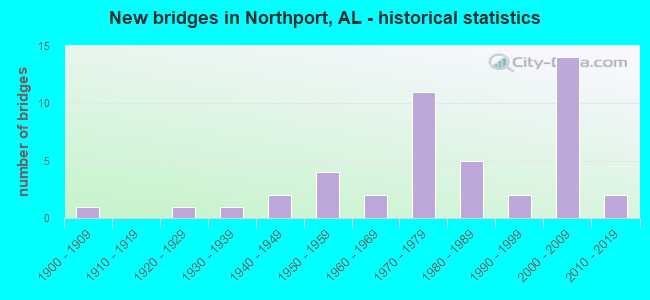
- New bridges - historical statistics
- 11900-1909
- 11920-1929
- 11930-1939
- 21940-1949
- 41950-1959
- 21960-1969
- 111970-1979
- 51980-1989
- 21990-1999
- 142000-2009
- 22010-2019

- Reconstructed bridges - Historical Statistics
- 21980-1989
- 01990-1999
- 12000-2009


- Bridge Condition - Deck
- 41.4%Very good
- 13.8%Good
- 31.0%Satisfactory
- 13.8%Fair

- Bridge Condition - Superstructure
- 44.8%Very good
- 10.3%Good
- 34.5%Satisfactory
- 10.3%Fair

- Bridge Condition - Substructure
- 41.4%Very good
- 17.2%Good
- 27.6%Satisfactory
- 6.9%Fair
- 3.4%Poor
- 3.4%Serious

- Bridge Condition - Channel
- 2.9%Excellent
- 11.4%Very good
- 37.1%Good
- 34.3%Satisfactory
- 14.3%Fair

- Bridge Condition - Culverts
- 10.0%Very good
- 10.0%Good
- 60.0%Satisfactory
- 20.0%Fair
Find on map >> Show street view
Structure Number: 10773, Location: HUGH THOMAS (Lat: 33.214100, Lng: -87.573600), Route carried "under" structure: City street , Year Built: 1973, Structure Length: 0. m, Average Daily Traffic: 6,720 (year 2008), Truck Traffic: 4%, Features Intersected: RIVER RD,MN AV,WARRIOR R, Facility Carried by Structure: US 43
Minimum Vertical Clearance: 8.23m (27.00ft), Kilometerpoint: 0.000, Lanes on structure: 6, Lanes under structure: 10, Material/Design: Steel continuous, Design/Construction: Girder and Floorbeam System, Length of Maximum Span: 79.2m (259.8ft)
Find on map >> Show street view
Structure Number: 10773, Location: HUGH THOMAS (Lat: 33.214100, Lng: -87.573600), Route carried "under" structure: City street , Year Built: 1973, Structure Length: 0. m, Average Daily Traffic: 2,240 (year 2008), Truck Traffic: 4%, Features Intersected: RIVER RD,MN AV,WARRIOR R, Facility Carried by Structure: US 43
Minimum Vertical Clearance: 3.05m (10.01ft), Kilometerpoint: 0.000, Lanes on structure: 6, Lanes under structure: 10, Material/Design: Steel continuous, Design/Construction: Girder and Floorbeam System, Length of Maximum Span: 79.2m (259.8ft)
Find on map >> Show street view
Structure Number: 11255, Location: NORTHPORT (Lat: 33.218567, Lng: -87.576000), Route carried "under" structure: City street , Year Built: 1974, Structure Length: 0. m, Average Daily Traffic: 11,621 (year 2007), Truck Traffic: 3%, Features Intersected: 5TH STREET, Facility Carried by Structure: US 43
Minimum Vertical Clearance: 5.00m (16.40ft), Kilometerpoint: 0.000, Lanes on structure: 2, Lanes under structure: 4, Material/Design: Steel continuous, Design/Construction: Stringer/Multi-beam, Length of Maximum Span: 30.5m (100.1ft)
Find on map >> Show street view
Structure Number: 11256, Location: NORTHPORT (Lat: 33.218533, Lng: -87.575783), Route carried "under" structure: City street , Year Built: 1974, Structure Length: 0. m, Average Daily Traffic: 11,621 (year 2007), Truck Traffic: 3%, Features Intersected: 5TH STREET, Facility Carried by Structure: US 43
Minimum Vertical Clearance: 5.49m (18.01ft), Kilometerpoint: 0.000, Lanes on structure: 2, Lanes under structure: 5, Material/Design: Steel continuous, Design/Construction: Stringer/Multi-beam, Length of Maximum Span: 30.5m (100.1ft)
Find on map >> Show street view
Structure Number: 18701, Location: 2.6 MI. N OF U.S. 43 (Lat: 33.294283, Lng: -87.627133), Route carried "under" structure: State highway 171, Year Built: 2004, Structure Length: 0. m, Average Daily Traffic: 3,410 (year 2013), Truck Traffic: 9%, Features Intersected: COUNTY ROAD 56
Minimum Vertical Clearance: 8.84m (29.00ft), Kilometerpoint: 4.184, Lanes on structure: 2, Lanes under structure: 2, Material/Design: Prestressed concrete, Design/Construction: Stringer/Multi-beam, Length of Maximum Span: 35.7m (117.1ft)