Bridge Statistics for O'Fallon, Missouri (MO)
Condition, Traffic, Stress, Structural Evaluation, Project Costs
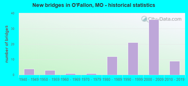
- New bridges - historical statistics
- 41940-1949
- 31950-1959
- 11960-1969
- 11970-1979
- 121980-1989
- 211990-1999
- 362000-2009
- 92010-2019
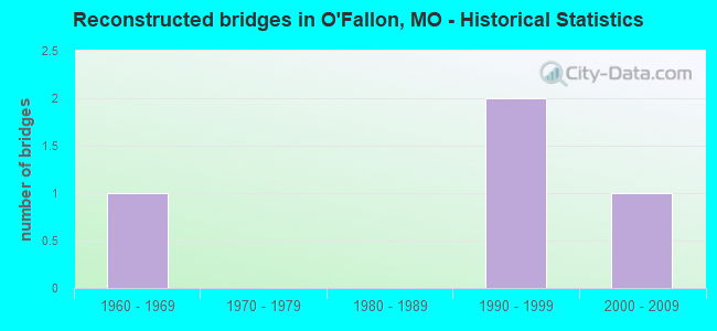
- Reconstructed bridges - Historical Statistics
- 11960-1969
- 01970-1979
- 01980-1989
- 21990-1999
- 12000-2009
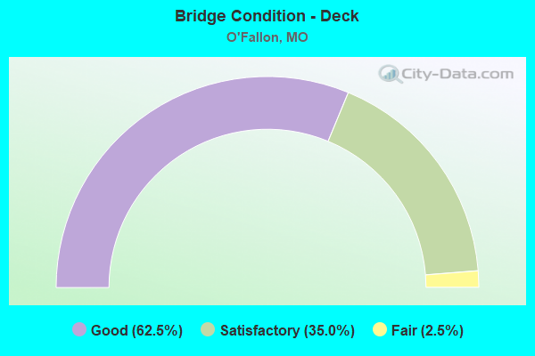
- Bridge Condition - Deck
- 62.5%Good
- 35.0%Satisfactory
- 2.5%Fair
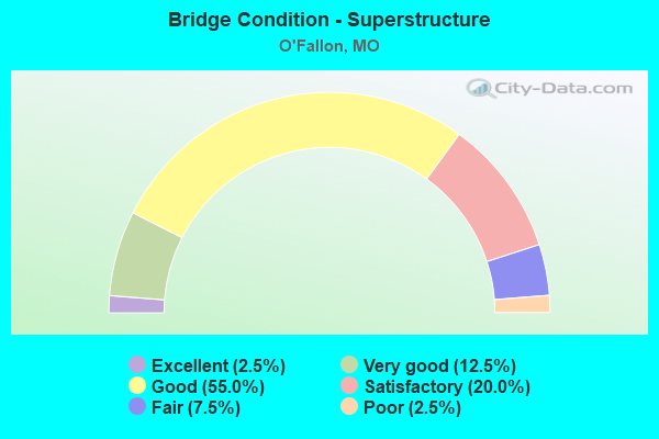
- Bridge Condition - Superstructure
- 2.5%Excellent
- 12.5%Very good
- 55.0%Good
- 20.0%Satisfactory
- 7.5%Fair
- 2.5%Poor
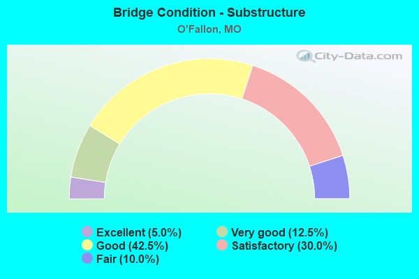
- Bridge Condition - Substructure
- 5.0%Excellent
- 12.5%Very good
- 42.5%Good
- 30.0%Satisfactory
- 10.0%Fair
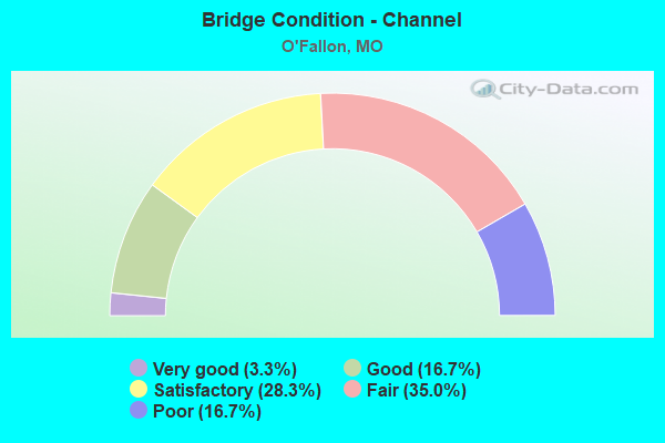
- Bridge Condition - Channel
- 3.3%Very good
- 16.7%Good
- 28.3%Satisfactory
- 35.0%Fair
- 16.7%Poor
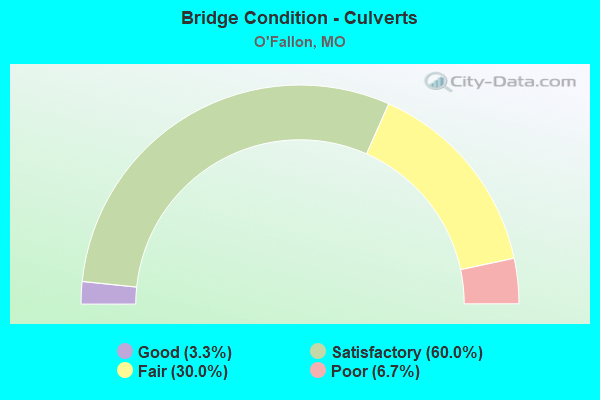
- Bridge Condition - Culverts
- 3.3%Good
- 60.0%Satisfactory
- 30.0%Fair
- 6.7%Poor
Find on map >> Show street view
Structure Number: 32951, Location: S 9 T 46 N R 3 E (Lat: 38.763556, Lng: -90.697944), Route carried "on" structure: City street , Year Built: 2002, Status: Open, Structure Length: 1.58m (5.18ft), Average Daily Traffic: 1,000 (year 2020), Truck Traffic: 10%, Average Future Daily Traffic: 1,550 (year 2040), Design Load: HS 20, Features Intersected: TRIB OF DARDENNE C, Facility Carried by Structure: FALLON PKWY
Minimum Vertical Clearance: 30+ m (98+ ft), Kilometerpoint: 0.000, Lanes on structure: 2, Owner: City or Municipal Highway Agency, Approaching Roadway Width: 11.6m (38.1ft), Material/Design: Concrete continuous, Design/Construction: Culvert, Number Of Spans In Main Unit: 3, Length of Maximum Span: 5.5m (18.0ft), Curb-To-Curb Width: 8.5m (27.9ft), Out-to-Out Width: 8.5m (27.9ft)
Condition: Channel: Satisfactory, Culverts: Satisfactory, Operating Rating: 54.0 metric tons, Method Used To Determine Operating Rating: Load Factor (LF), Inventory Rating: 32.4 metric tons, Method Used To Determine Inventory Rating: Load Factor (LF), Structural Evaluation: Equal to present minimum criteria, Deck Geometry: Somewhat better than minimum adequacy, Waterway Adequacy: Superior to present desirable criteria, Approach Roadway Alignment: Better than present minimum criteria, Designated Inspection Frequency: Every 24 months, Inspection Date: Febuary 2022
Find on map >> Show street view
Structure Number: 32952, Location: S 67 T 46 N R 3 E (Lat: 38.760667, Lng: -90.690056), Route carried "on" structure: City street , Year Built: 2002, Status: Open, Structure Length: 0.70m (2.30ft), Average Daily Traffic: 1,000 (year 2020), Truck Traffic: 10%, Average Future Daily Traffic: 1,550 (year 2040), Design Load: HS 20, Features Intersected: TRIB OF DARDENNE C, Facility Carried by Structure: AVONDALE SPRING DR
Minimum Vertical Clearance: 30+ m (98+ ft), Kilometerpoint: 0.000, Lanes on structure: 2, Owner: City or Municipal Highway Agency, Approaching Roadway Width: 7.3m (24.0ft), Material/Design: Concrete continuous, Design/Construction: Culvert, Number Of Spans In Main Unit: 2, Length of Maximum Span: 3.0m (9.8ft), Curb-To-Curb Width: 7.3m (24.0ft), Out-to-Out Width: 7.3m (24.0ft)
Condition: Channel: Fair, Culverts: Fair, Operating Rating: 54.0 metric tons, Method Used To Determine Operating Rating: Load Factor (LF), Inventory Rating: 32.4 metric tons, Method Used To Determine Inventory Rating: Load Factor (LF), Structural Evaluation: Somewhat better than minimum adequacy, Deck Geometry: Meets minimum limits, Waterway Adequacy: Superior to present desirable criteria, Approach Roadway Alignment: Equal to present desirable criteria, Designated Inspection Frequency: Every 24 months, Inspection Date: Febuary 2022
Find on map >> Show street view
Structure Number: 32953, Location: S 16 T 47 N R 3 E (Lat: 38.830750, Lng: -90.697694), Route carried "on" structure: City street , Year Built: 1996, Status: Open, Structure Length: 0.70m (2.30ft), Average Daily Traffic: 1,000 (year 2020), Truck Traffic: 10%, Average Future Daily Traffic: 1,550 (year 2040), Design Load: HS 20, Features Intersected: TRIB OF PERUQUE CR, Facility Carried by Structure: PIEPER RD
Minimum Vertical Clearance: 30+ m (98+ ft), Kilometerpoint: 0.000, Lanes on structure: 2, Owner: City or Municipal Highway Agency, Approaching Roadway Width: 10.7m (35.1ft), Skew: 4 degrees, Material/Design: Concrete continuous, Design/Construction: Culvert, Number Of Spans In Main Unit: 2, Length of Maximum Span: 3.0m (9.8ft)
Condition: Channel: Fair, Culverts: Satisfactory, Operating Rating: 54.0 metric tons, Method Used To Determine Operating Rating: Load Factor (LF), Inventory Rating: 32.4 metric tons, Method Used To Determine Inventory Rating: Load Factor (LF), Structural Evaluation: Equal to present minimum criteria, Waterway Adequacy: Superior to present desirable criteria, Approach Roadway Alignment: Better than present minimum criteria, Designated Inspection Frequency: Every 24 months, Inspection Date: Febuary 2022
Find on map >> Show street view
Structure Number: 32954, Location: S 33 T 47 N R 3 E (Lat: 38.793361, Lng: -90.690750), Route carried "on" structure: City street , Year Built: 2008, Status: Open, Structure Length: 5.30m (17.39ft), Average Daily Traffic: 5,700 (year 2020), Truck Traffic: 3%, Average Future Daily Traffic: 8,835 (year 2040), Design Load: HS 20, Features Intersected: BELLEAU CR, Facility Carried by Structure: SONDEREN ST
Minimum Vertical Clearance: 30+ m (98+ ft), Kilometerpoint: 0.000, Lanes on structure: 2, Owner: City or Municipal Highway Agency, Approaching Roadway Width: 8.2m (26.9ft), Skew: 2 degrees, Material/Design: Prestressed concrete continuous, Design/Construction: Stringer/Multi-beam, Number Of Spans In Main Unit: 3, Length of Maximum Span: 20.1m (65.9ft), Curb or Sidewalk Widths: Left: 2.1m (6.9ft), Right: 1.2m (3.9ft), Curb-To-Curb Width: 8.2m (26.9ft), Out-to-Out Width: 12.7m (41.7ft)
Condition: Deck: Good, Superstructure: Good, Substructure: Good, Channel: Good, Operating Rating: 58.5 metric tons, Method Used To Determine Operating Rating: Load Factor (LF), Inventory Rating: 35.1 metric tons, Method Used To Determine Inventory Rating: Load Factor (LF), Structural Evaluation: Better than present minimum criteria, Deck Geometry: High priority of replacement, Waterway Adequacy: Superior to present desirable criteria, Approach Roadway Alignment: Equal to present minimum criteria, Length Of Structure Improvement: 0.63m (2.07ft), Designated Inspection Frequency: Every 24 months, Inspection Date: Febuary 2022, Bridge Improvement Cost: $540,000, Roadway Improvement Cost: $54,000, Total Project Cost: $811,000 ( Estimate for 2022), Deck Structure Type: Concrete Precast Panels, Wearing Surface/Protective System: Wearing Surface: Monolithic Concrete, Deck Protection: Epoxy Coated Reinforcing
Find on map >> Show street view
Structure Number: 32959, Location: S 16 T 47 N R 3 E (Lat: 38.829883, Lng: -90.698019), Route carried "on" structure: City street , Year Built: 1984, Status: Open, Structure Length: 0.79m (2.59ft), Average Daily Traffic: 1,500 (year 2020), Truck Traffic: 10%, Average Future Daily Traffic: 2,325 (year 2040), Design Load: HS 20, Features Intersected: TRIB OF PERUQUE CR, Facility Carried by Structure: DEERFIELD ESTATE
Minimum Vertical Clearance: 30+ m (98+ ft), Kilometerpoint: 0.000, Lanes on structure: 2, Owner: City or Municipal Highway Agency, Approaching Roadway Width: 7.9m (25.9ft), Material/Design: Concrete continuous, Design/Construction: Culvert, Number Of Spans In Main Unit: 3, Length of Maximum Span: 2.4m (7.9ft)
Condition: Channel: Poor, Culverts: Satisfactory, Operating Rating: 54.0 metric tons, Method Used To Determine Operating Rating: Load Factor (LF), Inventory Rating: 32.4 metric tons, Method Used To Determine Inventory Rating: Load Factor (LF), Structural Evaluation: Equal to present minimum criteria, Waterway Adequacy: Superior to present desirable criteria, Approach Roadway Alignment: Equal to present desirable criteria, Designated Inspection Frequency: Every 24 months, Inspection Date: Febuary 2022
Find on map >> Show street view
Structure Number: 3296, Location: S 17 T 47 N R 3 E (Lat: 38.832906, Lng: -90.717181), Route carried "on" structure: City street , Year Built: 2008, Status: Open, Structure Length: 0.79m (2.59ft), Average Daily Traffic: 1,500 (year 2020), Truck Traffic: 10%, Average Future Daily Traffic: 2,325 (year 2040), Design Load: HS 20, Features Intersected: TRIB OF PERUQUE CR, Facility Carried by Structure: KOCH RD
Minimum Vertical Clearance: 30+ m (98+ ft), Kilometerpoint: 0.000, Lanes on structure: 2, Owner: City or Municipal Highway Agency, Approaching Roadway Width: 11.6m (38.1ft), Material/Design: Concrete continuous, Design/Construction: Culvert, Number Of Spans In Main Unit: 3, Length of Maximum Span: 2.4m (7.9ft)
Condition: Channel: Poor, Culverts: Satisfactory, Operating Rating: 54.0 metric tons, Method Used To Determine Operating Rating: Load Factor (LF), Inventory Rating: 32.4 metric tons, Method Used To Determine Inventory Rating: Load Factor (LF), Structural Evaluation: Equal to present minimum criteria, Waterway Adequacy: Superior to present desirable criteria, Approach Roadway Alignment: Better than present minimum criteria, Designated Inspection Frequency: Every 24 months, Inspection Date: Febuary 2022
Find on map >> Show street view
Structure Number: 33005, Location: S 33 T 47 N R 3 E (Lat: 38.792964, Lng: -90.696269), Route carried "on" structure: City street 321, Year Built: 2009, Status: Open, Structure Length: 1.28m (4.20ft), Average Daily Traffic: 2,000 (year 2020), Truck Traffic: 10%, Average Future Daily Traffic: 3,100 (year 2040), Design Load: HS 20, Features Intersected: BELLEAU CR, Facility Carried by Structure: BRAMBLETT RD
Minimum Vertical Clearance: 30+ m (98+ ft), Kilometerpoint: 0.000, Lanes on structure: 2, Owner: City or Municipal Highway Agency, Approaching Roadway Width: 8.5m (27.9ft), Skew: 3 degrees, Material/Design: Concrete continuous, Design/Construction: Culvert, Number Of Spans In Main Unit: 3, Length of Maximum Span: 4.0m (13.1ft), Curb or Sidewalk Widths: Left: 1.5m (4.9ft), Right: 1.5m (4.9ft), Curb-To-Curb Width: 8.5m (27.9ft), Out-to-Out Width: 8.5m (27.9ft)
Condition: Channel: Fair, Culverts: Satisfactory, Operating Rating: 68.4 metric tons, Method Used To Determine Operating Rating: Load Factor (LF), Inventory Rating: 41.4 metric tons, Method Used To Determine Inventory Rating: Load Factor (LF), Structural Evaluation: Equal to present minimum criteria, Deck Geometry: Somewhat better than minimum adequacy, Waterway Adequacy: Superior to present desirable criteria, Approach Roadway Alignment: Better than present minimum criteria, Designated Inspection Frequency: Every 24 months, Inspection Date: Febuary 2022
Find on map >> Show street view
Structure Number: 33195, Location: S 1669 T 46 N R 3 E (Lat: 38.734097, Lng: -90.722083), Route carried "on" structure: City street , Year Built: 2011, Status: Open, Structure Length: 2.04m (6.69ft), Average Daily Traffic: 4,122 (year 2020), Truck Traffic: 2%, Average Future Daily Traffic: 6,389 (year 2040), Design Load: HS 20, Features Intersected: OLD DARDENNE CR, Facility Carried by Structure: HENNING RD
Minimum Vertical Clearance: 30+ m (98+ ft), Kilometerpoint: 1.465, Lanes on structure: 2, Owner: City or Municipal Highway Agency, Maintenance Responsibility: County Highway Agency, Approaching Roadway Width: 11.0m (36.1ft), Skew: 2 degrees, Material/Design: Concrete continuous, Design/Construction: Culvert, Number Of Spans In Main Unit: 3, Length of Maximum Span: 3.5m (11.5ft)
Condition: Channel: Fair, Culverts: Satisfactory, Operating Rating: 54.0 metric tons, Method Used To Determine Operating Rating: Load Factor (LF), Inventory Rating: 32.4 metric tons, Method Used To Determine Inventory Rating: Load Factor (LF), Structural Evaluation: Equal to present minimum criteria, Waterway Adequacy: Superior to present desirable criteria, Approach Roadway Alignment: Equal to present desirable criteria, Designated Inspection Frequency: Every 24 months, Inspection Date: January 2022
Find on map >> Show street view
Structure Number: 34553, Location: S 3225 T 46 N R 3 E (Lat: 38.753500, Lng: -90.700300), Route carried "on" structure: State highway 364, Year Built: 2013, Status: Open, Structure Length: 6.01m (19.72ft), Average Daily Traffic: 17,924 (year 2021), Truck Traffic: 5%, Average Future Daily Traffic: 30,471 (year 2041), Features Intersected: RT K, RP MO364W TO RTKS,
Minimum Vertical Clearance: 30+ m (98+ ft), Kilometerpoint: 26.784, Lanes on structure: 2, Lanes under structure: 7, Base Highway Network: Yes, Owner: State Highway Agency, Approaching Roadway Width: 11.6m (38.1ft), Skew: 3 degrees, Material/Design: Steel, Design/Construction: Stringer/Multi-beam, Number Of Spans In Main Unit: 1, Length of Maximum Span: 59.2m (194.2ft), Curb-To-Curb Width: 11.6m (38.1ft), Out-to-Out Width: 12.4m (40.7ft)
Condition: Deck: Good, Superstructure: Very good, Substructure: Very good, Operating Rating: 71.1 metric tons, Method Used To Determine Operating Rating: Load Factor (LF), Inventory Rating: 42.3 metric tons, Method Used To Determine Inventory Rating: Load Factor (LF), Structural Evaluation: Equal to present desirable criteria, Deck Geometry: Equal to present minimum criteria, Approach Roadway Alignment: Equal to present desirable criteria, Designated Inspection Frequency: Every 24 months, Inspection Date: September 2021, Deck Structure Type: Concrete Cast-file-Place, Wearing Surface/Protective System: Wearing Surface: Monolithic Concrete, Deck Protection: Epoxy Coated Reinforcing
Find on map >> Show street view
Structure Number: 34554, Location: S 3225 T 46 N R 3 E (Lat: 38.753300, Lng: -90.700300), Route carried "on" structure: State highway 364, Year Built: 2013, Status: Open, Structure Length: 5.49m (18.01ft), Average Daily Traffic: 16,867 (year 2021), Truck Traffic: 6%, Average Future Daily Traffic: 28,674 (year 2041), Features Intersected: RT K, RP MO364E TO RTKN,
Minimum Vertical Clearance: 30+ m (98+ ft), Kilometerpoint: 7.564, Lanes on structure: 2, Lanes under structure: 7, Base Highway Network: Yes, Owner: State Highway Agency, Approaching Roadway Width: 11.6m (38.1ft), Skew: 3 degrees, Material/Design: Steel, Design/Construction: Stringer/Multi-beam, Number Of Spans In Main Unit: 1, Length of Maximum Span: 54.0m (177.2ft), Curb-To-Curb Width: 11.6m (38.1ft), Out-to-Out Width: 12.4m (40.7ft)
Condition: Deck: Good, Superstructure: Good, Substructure: Excellent, Operating Rating: 72.9 metric tons, Method Used To Determine Operating Rating: Load Factor (LF), Inventory Rating: 44.1 metric tons, Method Used To Determine Inventory Rating: Load Factor (LF), Structural Evaluation: Better than present minimum criteria, Deck Geometry: Equal to present minimum criteria, Approach Roadway Alignment: Equal to present desirable criteria, Designated Inspection Frequency: Every 24 months, Inspection Date: September 2021, Deck Structure Type: Concrete Cast-file-Place, Wearing Surface/Protective System: Wearing Surface: Monolithic Concrete, Deck Protection: Epoxy Coated Reinforcing
Find on map >> Show street view
Structure Number: 34594, Location: S 9 T 46 N R 3 E (Lat: 38.752000, Lng: -90.694700), Route carried "on" structure: State highway 364, Year Built: 2013, Status: Open, Structure Length: 3.95m (12.96ft), Average Daily Traffic: 16,867 (year 2021), Truck Traffic: 6%, Average Future Daily Traffic: 28,674 (year 2041), Features Intersected: TRIBUTARY B
Minimum Vertical Clearance: 30+ m (98+ ft), Kilometerpoint: 8.134, Lanes on structure: 2, Base Highway Network: Yes, Owner: State Highway Agency, Approaching Roadway Width: 11.6m (38.1ft), Skew: 2 degrees, Material/Design: Prestressed concrete, Design/Construction: Tee Beam, Number Of Spans In Main Unit: 1, Length of Maximum Span: 38.4m (126.0ft), Curb-To-Curb Width: 11.6m (38.1ft), Out-to-Out Width: 12.4m (40.7ft)
Condition: Deck: Good, Superstructure: Good, Substructure: Excellent, Channel: Good, Operating Rating: 78.3 metric tons, Method Used To Determine Operating Rating: Load Factor (LF), Inventory Rating: 43.2 metric tons, Method Used To Determine Inventory Rating: Load Factor (LF), Structural Evaluation: Better than present minimum criteria, Deck Geometry: Equal to present minimum criteria, Waterway Adequacy: Superior to present desirable criteria, Approach Roadway Alignment: Equal to present desirable criteria, Designated Inspection Frequency: Every 24 months, Inspection Date: September 2021, Deck Structure Type: Concrete Cast-file-Place, Wearing Surface/Protective System: Wearing Surface: Monolithic Concrete, Deck Protection: Epoxy Coated Reinforcing
Find on map >> Show street view
Structure Number: 34596, Location: S 9 T 46 N R 3 E (Lat: 38.752000, Lng: -90.694700), Route carried "on" structure: State highway 364, Year Built: 2013, Status: Open, Structure Length: 3.95m (12.96ft), Average Daily Traffic: 17,924 (year 2021), Truck Traffic: 5%, Average Future Daily Traffic: 30,471 (year 2041), Features Intersected: TRIBUTARY B
Minimum Vertical Clearance: 30+ m (98+ ft), Kilometerpoint: 26.239, Lanes on structure: 2, Base Highway Network: Yes, Owner: State Highway Agency, Approaching Roadway Width: 12.4m (40.7ft), Skew: 2 degrees, Material/Design: Prestressed concrete, Design/Construction: Tee Beam, Number Of Spans In Main Unit: 1, Length of Maximum Span: 38.4m (126.0ft), Curb-To-Curb Width: 12.4m (40.7ft), Out-to-Out Width: 13.2m (43.3ft)
Condition: Deck: Good, Superstructure: Good, Substructure: Very good, Channel: Good, Operating Rating: 81.9 metric tons, Method Used To Determine Operating Rating: Load Factor (LF), Inventory Rating: 45.0 metric tons, Method Used To Determine Inventory Rating: Load Factor (LF), Structural Evaluation: Better than present minimum criteria, Deck Geometry: Better than present minimum criteria, Waterway Adequacy: Superior to present desirable criteria, Approach Roadway Alignment: Equal to present desirable criteria, Designated Inspection Frequency: Every 24 months, Inspection Date: September 2021, Deck Structure Type: Concrete Cast-file-Place, Wearing Surface/Protective System: Wearing Surface: Monolithic Concrete, Deck Protection: Epoxy Coated Reinforcing
Find on map >> Show street view
Structure Number: 351, Location: S 23 T 30 N R 13 E (Lat: 37.260275, Lng: -89.567211), Route carried "on" structure: Interstate 55, Year Built: 1961, Status: Open, Structure Length: 4.60m (15.09ft), Average Daily Traffic: 19,835 (year 2021), Truck Traffic: 22%, Average Future Daily Traffic: 38,678 (year 2041), Design Load: HS 20+Mod, Features Intersected: MO 74, CST SPRIGG ST
Minimum Vertical Clearance: 30+ m (98+ ft), Kilometerpoint: 150.290, Lanes on structure: 2, Lanes under structure: 4, Base Highway Network: Yes, Owner: State Highway Agency, Approaching Roadway Width: 11.6m (38.1ft), Material/Design: Steel continuous, Design/Construction: Stringer/Multi-beam, Number Of Spans In Main Unit: 3, Length of Maximum Span: 15.8m (51.8ft), Curb-To-Curb Width: 9.1m (29.9ft), Out-to-Out Width: 10.2m (33.5ft)
Condition: Deck: Satisfactory, Superstructure: Good, Substructure: Good, Operating Rating: 44.1 metric tons, Method Used To Determine Operating Rating: Load Factor (LF), Inventory Rating: 26.1 metric tons, Method Used To Determine Inventory Rating: Load Factor (LF), Structural Evaluation: Equal to present minimum criteria, Deck Geometry: High priority of replacement, Underclear: Equal to present minimum criteria, Approach Roadway Alignment: Equal to present desirable criteria, Length Of Structure Improvement: 0.56m (1.84ft), Designated Inspection Frequency: Every 24 months, Inspection Date: November 2021, Bridge Improvement Cost: $458,000, Roadway Improvement Cost: $46,000, Total Project Cost: $687,000 ( Estimate for 2022), Deck Structure Type: Concrete Cast-file-Place, Wearing Surface/Protective System: Wearing Surface: Monolithic Concrete, Deck Protection: Internally Sealed
Find on map >> Show street view
Structure Number: 351, Location: S 731 T 47 N R 3 E (Lat: 38.807728, Lng: -90.649347), Route carried "on" structure: State highway 79, Year Built: 1985, Status: Open, Structure Length: 5.79m (19.00ft), Average Daily Traffic: 10,522 (year 2021), Truck Traffic: 11%, Average Future Daily Traffic: 18,940 (year 2041), Design Load: HS 20+Mod, Features Intersected: OR 70, NS RR
Minimum Vertical Clearance: 30+ m (98+ ft), Kilometerpoint: 0.956, Lanes on structure: 3, Lanes under structure: 2, Base Highway Network: Yes, Owner: State Highway Agency, Approaching Roadway Width: 12.2m (40.0ft), Material/Design: Prestressed concrete continuous, Design/Construction: Tee Beam, Number Of Spans In Main Unit: 4, Length of Maximum Span: 15.4m (50.5ft), Curb or Sidewalk Widths: Left: 0.2m (0.7ft), Right: 0.2m (0.7ft), Curb-To-Curb Width: 14.3m (46.9ft), Out-to-Out Width: 15.1m (49.5ft)
Condition: Deck: Satisfactory, Superstructure: Fair, Substructure: Satisfactory, Operating Rating: 65.7 metric tons, Method Used To Determine Operating Rating: Load Factor (LF), Inventory Rating: 39.6 metric tons, Method Used To Determine Inventory Rating: Load Factor (LF), Structural Evaluation: Somewhat better than minimum adequacy, Deck Geometry: Somewhat better than minimum adequacy, Underclear: Somewhat better than minimum adequacy, Approach Roadway Alignment: Equal to present desirable criteria, Designated Inspection Frequency: Every 24 months, Inspection Date: September 2020, Deck Structure Type: Concrete Cast-file-Place, Wearing Surface/Protective System: Wearing Surface: Monolithic Concrete, Deck Protection: Epoxy Coated Reinforcing
Find on map >> Show street view
Structure Number: 3511, Location: S 731 T 47 N R 3 E (Lat: 38.801742, Lng: -90.651706), Route carried "on" structure: State highway 79, Year Built: 1985, Status: Open, Structure Length: 8.29m (27.20ft), Average Daily Traffic: 16,279 (year 2021), Truck Traffic: 5%, Average Future Daily Traffic: 29,302 (year 2041), Design Load: HS 20+Mod, Features Intersected: IS 70
Minimum Vertical Clearance: 30+ m (98+ ft), Kilometerpoint: 141.180, Lanes on structure: 5, Lanes under structure: 8, Base Highway Network: Yes, Owner: State Highway Agency, Approaching Roadway Width: 24.4m (80.1ft), Skew: 1 degrees, Material/Design: Steel continuous, Design/Construction: Stringer/Multi-beam, Number Of Spans In Main Unit: 2, Length of Maximum Span: 34.2m (112.2ft), Curb or Sidewalk Widths: Left: 0.2m (0.7ft), Right: 0.2m (0.7ft), Curb-To-Curb Width: 24.0m (78.7ft), Out-to-Out Width: 24.8m (81.4ft)
Condition: Deck: Satisfactory, Superstructure: Satisfactory, Substructure: Satisfactory, Operating Rating: 64.8 metric tons, Method Used To Determine Operating Rating: Load Factor (LF), Inventory Rating: 38.7 metric tons, Method Used To Determine Inventory Rating: Load Factor (LF), Structural Evaluation: Equal to present minimum criteria, Deck Geometry: Equal to present desirable criteria, Underclear: Equal to present minimum criteria, Approach Roadway Alignment: Equal to present desirable criteria, Designated Inspection Frequency: Every 24 months, Inspection Date: September 2021, Deck Structure Type: Concrete Cast-file-Place, Wearing Surface/Protective System: Wearing Surface: Epoxy Overlay, Deck Protection: Epoxy Coated Reinforcing
Find on map >> Show street view
Structure Number: 35243, Location: S 28 T 46 N R 2 W (Lat: 38.718333, Lng: -90.808889), Route carried "on" structure: County highway 297, Year Built: 2015, Status: Open, Structure Length: 2.59m (8.50ft), Average Daily Traffic: 100 (year 2020), Truck Traffic: 5%, Average Future Daily Traffic: 220 (year 2040), Design Load: HS 20, Features Intersected: KRAUT RUN CR, Facility Carried by Structure: BROEMMELSIEK PARK
Minimum Vertical Clearance: 30+ m (98+ ft), Kilometerpoint: 0.966, Lanes on structure: 2, Owner: County Highway Agency, Approaching Roadway Width: 7.6m (24.9ft), Material/Design: Steel, Design/Construction: Truss - Thru, Number Of Spans In Main Unit: 1, Length of Maximum Span: 23.8m (78.1ft), Curb-To-Curb Width: 9.1m (29.9ft), Out-to-Out Width: 9.1m (29.9ft)
Condition: Deck: Good, Superstructure: Very good, Substructure: Good, Channel: Satisfactory, Operating Rating: 54.0 metric tons, Method Used To Determine Operating Rating: Load Factor (LF), Inventory Rating: 32.4 metric tons, Method Used To Determine Inventory Rating: Load Factor (LF), Structural Evaluation: Better than present minimum criteria, Deck Geometry: Better than present minimum criteria, Waterway Adequacy: Equal to present desirable criteria, Approach Roadway Alignment: Equal to present desirable criteria, Designated Inspection Frequency: Every 24 months, Critical Feature Inspection Frequency: Every 24 months, Inspection Date: Febuary 2022, Critical Feature Inspection Date: May 2020, Deck Structure Type: Concrete Cast-file-Place
Find on map >> Show street view
Structure Number: 35524, Location: S 16 T 46 N R 3 E (Lat: 38.739700, Lng: -90.698531), Route carried "on" structure: City street , Year Built: 2003, Status: Posted for load, Structure Length: 3.55m (11.65ft), Average Daily Traffic: 2,000 (year 2020), Truck Traffic: 5%, Average Future Daily Traffic: 3,100 (year 2040), Design Load: HS 20, Features Intersected: DARDENNE CR, Facility Carried by Structure: SPORTS PARK DR
Minimum Vertical Clearance: 30+ m (98+ ft), Kilometerpoint: 0.966, Lanes on structure: 2, Owner: City or Municipal Highway Agency, Approaching Roadway Width: 6.7m (22.0ft), Material/Design: Steel continuous, Design/Construction: Stringer/Multi-beam, Number Of Spans In Main Unit: 3, Length of Maximum Span: 13.7m (44.9ft), Curb or Sidewalk Widths: Left: 1.2m (3.9ft), Right: 0.0m, Curb-To-Curb Width: 6.7m (22.0ft), Out-to-Out Width: 8.7m (28.5ft)
Condition: Deck: Good, Superstructure: Good, Substructure: Satisfactory, Channel: Fair, Operating Rating: 83.7 metric tons, Method Used To Determine Operating Rating: Load Factor (LF), Inventory Rating: 50.4 metric tons, Method Used To Determine Inventory Rating: Load Factor (LF), Structural Evaluation: Equal to present minimum criteria, Deck Geometry: High priority of corrective action, Waterway Adequacy: Better than present minimum criteria, Approach Roadway Alignment: Meets minimum limits, Length Of Structure Improvement: 0.45m (1.48ft), Designated Inspection Frequency: Every 24 months, Inspection Date: Febuary 2022, Bridge Improvement Cost: $332,000, Roadway Improvement Cost: $33,000, Total Project Cost: $498,000 ( Estimate for 2022), Deck Structure Type: Concrete Cast-file-Place, Wearing Surface/Protective System: Wearing Surface: Monolithic Concrete, Deck Protection: Epoxy Coated Reinforcing
Find on map >> Show street view
Structure Number: 35808, Location: S 19 T 47 N R 3 E (Lat: 38.821944, Lng: -90.726389), Route carried "on" structure: City street 321, Year Built: 2016, Status: Open, Structure Length: 22.86m (75.00ft), Average Daily Traffic: 600 (year 2020), Truck Traffic: 10%, Average Future Daily Traffic: 930 (year 2040), Features Intersected: PERUQUE CR, Facility Carried by Structure: DEER CR DR
Minimum Vertical Clearance: 30+ m (98+ ft), Kilometerpoint: 5.633, Lanes on structure: 2, Owner: City or Municipal Highway Agency, Approaching Roadway Width: 9.8m (32.2ft), Material/Design: Steel continuous, Design/Construction: Stringer/Multi-beam, Number Of Spans In Main Unit: 4, Number Of Approach Spans: 4, Length of Maximum Span: 39.6m (129.9ft), Curb or Sidewalk Widths: Left: 0.4m (1.3ft), Right: 2.2m (7.2ft), Curb-To-Curb Width: 9.1m (29.9ft), Out-to-Out Width: 11.7m (38.4ft)
Condition: Deck: Good, Superstructure: Good, Substructure: Good, Channel: Fair, Operating Rating: 54.0 metric tons, Method Used To Determine Operating Rating: Load Factor (LF), Inventory Rating: 28.8 metric tons, Method Used To Determine Inventory Rating: Load Factor (LF), Structural Evaluation: Better than present minimum criteria, Deck Geometry: Equal to present minimum criteria, Waterway Adequacy: Superior to present desirable criteria, Approach Roadway Alignment: Equal to present minimum criteria, Designated Inspection Frequency: Every 24 months, Inspection Date: Febuary 2022, Deck Structure Type: Concrete Cast-file-Place, Wearing Surface/Protective System: Wearing Surface: Monolithic Concrete, Deck Protection: Epoxy Coated Reinforcing
Find on map >> Show street view
Structure Number: 371, Location: S 33 T 47 N R 3 E (Lat: 38.790722, Lng: -90.698500), Route carried "on" structure: State highway K, Year Built: 1987, Status: Open, Structure Length: 1.00m (3.28ft), Average Daily Traffic: 53,239 (year 2021), Truck Traffic: 5%, Average Future Daily Traffic: 95,830 (year 2041), Design Load: HS 20, Features Intersected: BELLEAU CR
Minimum Vertical Clearance: 30+ m (98+ ft), Kilometerpoint: 1.387, Lanes on structure: 4, Base Highway Network: Yes, Owner: State Highway Agency, Approaching Roadway Width: 25.0m (82.0ft), Skew: 1 degrees, Material/Design: Concrete, Design/Construction: Culvert, Number Of Spans In Main Unit: 3, Length of Maximum Span: 3.0m (9.8ft)
Condition: Channel: Fair, Culverts: Fair, Operating Rating: 87.3 metric tons, Method Used To Determine Operating Rating: Field evaluation and documented engineering judgment, Inventory Rating: 52.2 metric tons, Method Used To Determine Inventory Rating: Field evaluation and documented engineering judgment, Structural Evaluation: Somewhat better than minimum adequacy, Waterway Adequacy: Equal to present desirable criteria, Approach Roadway Alignment: Equal to present desirable criteria, Designated Inspection Frequency: Every 24 months, Inspection Date: November 2021
Find on map >> Show street view
Structure Number: 4078, Location: S 1696 T 46 N R 3 E (Lat: 38.741078, Lng: -90.695353), Route carried "on" structure: State highway K, Year Built: 1996, Status: Open, Structure Length: 17.10m (56.10ft), Average Daily Traffic: 31,414 (year 2021), Truck Traffic: 5%, Average Future Daily Traffic: 56,545 (year 2041), Design Load: HS 20, Features Intersected: DARDENNE CR
Minimum Vertical Clearance: 30+ m (98+ ft), Kilometerpoint: 6.973, Lanes on structure: 5, Base Highway Network: Yes, Owner: State Highway Agency, Approaching Roadway Width: 25.0m (82.0ft), Skew: 1 degrees, Material/Design: Prestressed concrete continuous, Design/Construction: Stringer/Multi-beam, Number Of Spans In Main Unit: 8, Length of Maximum Span: 21.5m (70.5ft), Curb or Sidewalk Widths: Left: 0.2m (0.7ft), Right: 0.2m (0.7ft), Curb-To-Curb Width: 24.6m (80.7ft), Out-to-Out Width: 25.5m (83.7ft)
Condition: Deck: Satisfactory, Superstructure: Good, Substructure: Satisfactory, Channel: Good, Operating Rating: 73.8 metric tons, Method Used To Determine Operating Rating: Load Factor (LF), Inventory Rating: 33.3 metric tons, Method Used To Determine Inventory Rating: Load Factor (LF), Structural Evaluation: Equal to present minimum criteria, Deck Geometry: Superior to present desirable criteria, Waterway Adequacy: Equal to present desirable criteria, Approach Roadway Alignment: Equal to present desirable criteria, Designated Inspection Frequency: Every 24 months, Inspection Date: September 2021, Deck Structure Type: Concrete Cast-file-Place, Wearing Surface/Protective System: Wearing Surface: Monolithic Concrete, Deck Protection: Epoxy Coated Reinforcing
Find on map >> Show street view
Structure Number: 4079, Location: S 1696 T 46 N R 3 E (Lat: 38.738994, Lng: -90.693900), Route carried "on" structure: State highway K, Year Built: 1996, Status: Open, Structure Length: 4.30m (14.11ft), Average Daily Traffic: 31,414 (year 2021), Truck Traffic: 5%, Average Future Daily Traffic: 56,545 (year 2041), Design Load: HS 20, Features Intersected: SCHOTE CR
Minimum Vertical Clearance: 30+ m (98+ ft), Kilometerpoint: 7.292, Lanes on structure: 5, Base Highway Network: Yes, Owner: State Highway Agency, Approaching Roadway Width: 25.0m (82.0ft), Skew: 3 degrees, Material/Design: Prestressed concrete continuous, Design/Construction: Stringer/Multi-beam, Number Of Spans In Main Unit: 2, Length of Maximum Span: 21.6m (70.9ft), Curb or Sidewalk Widths: Left: 0.2m (0.7ft), Right: 0.2m (0.7ft), Curb-To-Curb Width: 24.6m (80.7ft), Out-to-Out Width: 25.5m (83.7ft)
Condition: Deck: Satisfactory, Superstructure: Good, Substructure: Satisfactory, Channel: Good, Operating Rating: 71.1 metric tons, Method Used To Determine Operating Rating: Load Factor (LF), Inventory Rating: 32.4 metric tons, Method Used To Determine Inventory Rating: Load Factor (LF), Structural Evaluation: Equal to present minimum criteria, Deck Geometry: Superior to present desirable criteria, Waterway Adequacy: Equal to present desirable criteria, Approach Roadway Alignment: Equal to present desirable criteria, Designated Inspection Frequency: Every 24 months, Inspection Date: September 2021, Deck Structure Type: Concrete Cast-file-Place, Wearing Surface/Protective System: Wearing Surface: Monolithic Concrete, Deck Protection: Epoxy Coated Reinforcing
Find on map >> Show street view
Structure Number: 408, Location: S 8 T 46 N R 3 E (Lat: 38.758389, Lng: -90.700194), Route carried "on" structure: State highway K, Year Built: 1993, Status: Open, Structure Length: 0.95m (3.12ft), Average Daily Traffic: 40,538 (year 2021), Truck Traffic: 5%, Average Future Daily Traffic: 72,968 (year 2041), Design Load: HS 20, Features Intersected: BRASSELS BR
Minimum Vertical Clearance: 30+ m (98+ ft), Kilometerpoint: 5.029, Lanes on structure: 5, Base Highway Network: Yes, Owner: State Highway Agency, Approaching Roadway Width: 26.8m (87.9ft), Material/Design: Concrete, Design/Construction: Culvert, Number Of Spans In Main Unit: 3, Length of Maximum Span: 3.0m (9.8ft)
Condition: Channel: Fair, Culverts: Satisfactory, Inventory Rating: 68.4 metric tons, Method Used To Determine Inventory Rating: Load Factor (LF), Structural Evaluation: Equal to present minimum criteria, Waterway Adequacy: Equal to present desirable criteria, Approach Roadway Alignment: Equal to present desirable criteria, Designated Inspection Frequency: Every 24 months, Inspection Date: November 2021
Find on map >> Show street view
Structure Number: 4109, Location: S 67 T 46 N R 3 E (Lat: 38.754442, Lng: -90.694014), Route carried "on" structure: State highway N, Year Built: 1993, Status: Open, Structure Length: 1.18m (3.87ft), Average Daily Traffic: 9,307 (year 2021), Truck Traffic: 4%, Average Future Daily Traffic: 16,753 (year 2041), Design Load: HS 20, Features Intersected: BR DARDENNE CR
Minimum Vertical Clearance: 30+ m (98+ ft), Kilometerpoint: 25.645, Lanes on structure: 2, Owner: State Highway Agency, Approaching Roadway Width: 7.3m (24.0ft), Skew: 1 degrees, Material/Design: Concrete, Design/Construction: Culvert, Number Of Spans In Main Unit: 3, Length of Maximum Span: 3.7m (12.1ft)
Condition: Channel: Poor, Culverts: Satisfactory, Operating Rating: 64.8 metric tons, Method Used To Determine Operating Rating: Load Factor (LF), Inventory Rating: 38.7 metric tons, Method Used To Determine Inventory Rating: Load Factor (LF), Structural Evaluation: Equal to present minimum criteria, Waterway Adequacy: Equal to present desirable criteria, Approach Roadway Alignment: Equal to present desirable criteria, Designated Inspection Frequency: Every 24 months, Inspection Date: November 2021
Find on map >> Show street view
Structure Number: 6057, Location: S 28 T 46 N R 2 E (Lat: 38.720697, Lng: -90.800319), Route carried "on" structure: State highway DD, Year Built: 1943, Status: Open, Structure Length: 0.88m (2.89ft), Average Daily Traffic: 2,536 (year 2021), Truck Traffic: 11%, Average Future Daily Traffic: 4,945 (year 2041), Design Load: H 15, Features Intersected: KRAUT-RUN CR
Minimum Vertical Clearance: 30+ m (98+ ft), Kilometerpoint: 6.659, Lanes on structure: 2, Owner: State Highway Agency, Approaching Roadway Width: 11.0m (36.1ft), Skew: 3 degrees, Material/Design: Concrete continuous, Design/Construction: Culvert, Number Of Spans In Main Unit: 2, Length of Maximum Span: 3.7m (12.1ft), Curb-To-Curb Width: 8.4m (27.6ft), Out-to-Out Width: 9.0m (29.5ft)
Condition: Channel: Poor, Culverts: Satisfactory, Inventory Rating: 61.2 metric tons, Method Used To Determine Inventory Rating: Load Factor (LF), Structural Evaluation: Equal to present minimum criteria, Deck Geometry: High priority of corrective action, Waterway Adequacy: Equal to present minimum criteria, Approach Roadway Alignment: Equal to present minimum criteria, Designated Inspection Frequency: Every 24 months, Inspection Date: November 2021
Find on map >> Show street view
Structure Number: 6059, Location: S 15 T 46 N R 2 E (Lat: 38.741264, Lng: -90.792736), Route carried "on" structure: State highway DD, Year Built: 1943, Status: Open, Structure Length: 1.16m (3.81ft), Average Daily Traffic: 8,840 (year 2021), Truck Traffic: 10%, Average Future Daily Traffic: 17,238 (year 2041), Design Load: H 15, Features Intersected: SCHIERBAUM CR
Minimum Vertical Clearance: 30+ m (98+ ft), Kilometerpoint: 3.767, Lanes on structure: 2, Owner: State Highway Agency, Approaching Roadway Width: 7.3m (24.0ft), Material/Design: Concrete continuous, Design/Construction: Culvert, Number Of Spans In Main Unit: 3, Length of Maximum Span: 3.7m (12.1ft), Curb-To-Curb Width: 9.6m (31.5ft), Out-to-Out Width: 10.1m (33.1ft)
Condition: Channel: Fair, Culverts: Satisfactory, Operating Rating: 84.6 metric tons, Method Used To Determine Operating Rating: Load Factor (LF), Inventory Rating: 51.3 metric tons, Method Used To Determine Inventory Rating: Load Factor (LF), Structural Evaluation: Equal to present minimum criteria, Deck Geometry: High priority of corrective action, Waterway Adequacy: Better than present minimum criteria, Approach Roadway Alignment: Equal to present minimum criteria, Designated Inspection Frequency: Every 24 months, Inspection Date: November 2021
Find on map >> Show street view
Structure Number: 6449, Location: S 32 T 47 N R 3 E (Lat: 38.802428, Lng: -90.700200), Route carried "on" structure: Interstate 70, Year Built: 1955, Year Reconstructed: 1971, Status: Posted for load, Structure Length: 5.12m (16.80ft), Average Daily Traffic: 107,120 (year 2021), Truck Traffic: 12%, Average Future Daily Traffic: 182,104 (year 2041), Design Load: HS 20, Features Intersected: RT K, CO OR70W TO OR70E,
Minimum Vertical Clearance: 30+ m (98+ ft), Kilometerpoint: 350.561, Lanes on structure: 6, Lanes under structure: 8, Base Highway Network: Yes, Owner: State Highway Agency, Approaching Roadway Width: 16.1m (52.8ft), Material/Design: Steel continuous, Design/Construction: Stringer/Multi-beam, Number Of Spans In Main Unit: 4, Length of Maximum Span: 14.3m (46.9ft), Curb-To-Curb Width: 32.3m (106.0ft), Out-to-Out Width: 33.9m (111.2ft)
Condition: Deck: Satisfactory, Superstructure: Good, Substructure: Satisfactory, Operating Rating: 46.8 metric tons, Method Used To Determine Operating Rating: Load Factor (LF), Inventory Rating: 27.9 metric tons, Method Used To Determine Inventory Rating: Load Factor (LF), Structural Evaluation: Equal to present minimum criteria, Deck Geometry: Superior to present desirable criteria, Underclear: High priority of corrective action, Approach Roadway Alignment: Equal to present desirable criteria, Designated Inspection Frequency: Every 24 months, Inspection Date: September 2021, Deck Structure Type: Concrete Cast-file-Place, Wearing Surface/Protective System: Wearing Surface: Epoxy Overlay, Deck Protection: Epoxy Coated Reinforcing
Find on map >> Show street view
Structure Number: 645, Location: S 27 T 47 N R 3 E (Lat: 38.803119, Lng: -90.677375), Route carried "on" structure: Interstate 70, Year Built: 1955, Year Reconstructed: 2012, Status: Open, Structure Length: 3.11m (10.20ft), Average Daily Traffic: 107,646 (year 2021), Truck Traffic: 12%, Average Future Daily Traffic: 182,998 (year 2041), Design Load: HS 20, Features Intersected: BELLEAU CR
Minimum Vertical Clearance: 30+ m (98+ ft), Kilometerpoint: 352.587, Lanes on structure: 7, Base Highway Network: Yes, Owner: State Highway Agency, Approaching Roadway Width: 34.1m (111.9ft), Material/Design: Steel, Design/Construction: Stringer/Multi-beam, Number Of Spans In Main Unit: 3, Length of Maximum Span: 15.3m (50.2ft), Curb-To-Curb Width: 36.4m (119.4ft), Out-to-Out Width: 37.2m (122.0ft)
Condition: Deck: Good, Superstructure: Fair, Substructure: Fair, Channel: Satisfactory, Operating Rating: 87.3 metric tons, Method Used To Determine Operating Rating: Load Factor (LF), Inventory Rating: 52.2 metric tons, Method Used To Determine Inventory Rating: Load Factor (LF), Structural Evaluation: Somewhat better than minimum adequacy, Deck Geometry: Superior to present desirable criteria, Waterway Adequacy: Equal to present minimum criteria, Approach Roadway Alignment: Equal to present desirable criteria, Designated Inspection Frequency: Every 24 months, Inspection Date: September 2021, Deck Structure Type: Concrete Cast-file-Place, Wearing Surface/Protective System: Wearing Surface: Epoxy Overlay, Deck Protection: Epoxy Coated Reinforcing
Find on map >> Show street view
Structure Number: 11919, Location: S 13 T 46 N R 2 E (Lat: 38.749072, Lng: -90.753494), Route carried "under" structure: Interstate 64, Year Built: 2000, Structure Length: 0. m, Average Daily Traffic: 27,968 (year 2021), Truck Traffic: 7%, Features Intersected: IS 64, Facility Carried by Structure: RT DD N
Minimum Vertical Clearance: 5.23m (17.16ft), Kilometerpoint: 55.564, Lanes on structure: 6, Lanes under structure: 2, Material/Design: Prestressed concrete continuous, Design/Construction: Stringer/Multi-beam, Length of Maximum Span: 25.0m (82.0ft)
Find on map >> Show street view
Structure Number: 11919, Location: S 13 T 46 N R 2 E (Lat: 38.749072, Lng: -90.753494), Route carried "under" structure: Interstate 64, Year Built: 2000, Structure Length: 0. m, Average Daily Traffic: 26,276 (year 2021), Truck Traffic: 12%, Features Intersected: IS 64, Facility Carried by Structure: RT DD N
Minimum Vertical Clearance: 5.66m (18.57ft), Kilometerpoint: 10.108, Lanes on structure: 6, Lanes under structure: 2, Material/Design: Prestressed concrete continuous, Design/Construction: Stringer/Multi-beam, Length of Maximum Span: 25.0m (82.0ft)
Find on map >> Show street view
Structure Number: 1192, Location: S 29 T 47 N R 3 E (Lat: 38.802369, Lng: -90.705169), Route carried "under" structure: Interstate 70, Year Built: 1999, Structure Length: 0. m, Average Daily Traffic: 45,468 (year 2021), Truck Traffic: 12%, Features Intersected: IS 70, Facility Carried by Structure: WOODLAWN AVE S
Minimum Vertical Clearance: 5.13m (16.83ft), Kilometerpoint: 52.350, Lanes on structure: 4, Lanes under structure: 4, Material/Design: Steel continuous, Design/Construction: Stringer/Multi-beam, Length of Maximum Span: 36.4m (119.4ft)
Find on map >> Show street view
Structure Number: 1192, Location: S 29 T 47 N R 3 E (Lat: 38.802369, Lng: -90.705169), Route carried "under" structure: Interstate 70, Year Built: 1999, Structure Length: 0. m, Average Daily Traffic: 54,834 (year 2021), Truck Traffic: 12%, Features Intersected: IS 70, Facility Carried by Structure: WOODLAWN AVE S
Minimum Vertical Clearance: 5.06m (16.60ft), Kilometerpoint: 350.186, Lanes on structure: 4, Lanes under structure: 4, Material/Design: Steel continuous, Design/Construction: Stringer/Multi-beam, Length of Maximum Span: 36.4m (119.4ft)
Find on map >> Show street view
Structure Number: 12024, Location: S 27 T 47 N R 3 E (Lat: 38.803117, Lng: -90.678539), Route carried "under" structure: Interstate 70, Year Built: 2000, Structure Length: 0. m, Average Daily Traffic: 55,360 (year 2021), Truck Traffic: 12%, Features Intersected: IS 70, Facility Carried by Structure: T R HUGHES BLVD S
Minimum Vertical Clearance: 5.56m (18.24ft), Kilometerpoint: 352.500, Lanes on structure: 7, Lanes under structure: 3, Material/Design: Prestressed concrete continuous, Design/Construction: Stringer/Multi-beam, Length of Maximum Span: 22.5m (73.8ft)
Find on map >> Show street view
Structure Number: 12024, Location: S 27 T 47 N R 3 E (Lat: 38.803117, Lng: -90.678539), Route carried "under" structure: Interstate 70, Year Built: 2000, Structure Length: 0. m, Average Daily Traffic: 52,286 (year 2021), Truck Traffic: 12%, Features Intersected: IS 70, Facility Carried by Structure: T R HUGHES BLVD S
Minimum Vertical Clearance: 5.64m (18.50ft), Kilometerpoint: 50.038, Lanes on structure: 7, Lanes under structure: 4, Material/Design: Prestressed concrete continuous, Design/Construction: Stringer/Multi-beam, Length of Maximum Span: 22.5m (73.8ft)
Find on map >> Show street view
Structure Number: 12142, Location: S 28 T 47 N R 3 E (Lat: 38.802675, Lng: -90.695067), Route carried "under" structure: Interstate 70, Year Built: 2000, Structure Length: 0. m, Average Daily Traffic: 52,286 (year 2021), Truck Traffic: 12%, Features Intersected: IS 70, Facility Carried by Structure: SONDEREN ST S
Minimum Vertical Clearance: 5.39m (17.68ft), Kilometerpoint: 51.475, Lanes on structure: 2, Lanes under structure: 4, Material/Design: Prestressed concrete continuous, Design/Construction: Stringer/Multi-beam, Length of Maximum Span: 25.0m (82.0ft)
Find on map >> Show street view
Structure Number: 12142, Location: S 28 T 47 N R 3 E (Lat: 38.802675, Lng: -90.695067), Route carried "under" structure: Interstate 70, Year Built: 2000, Structure Length: 0. m, Average Daily Traffic: 55,360 (year 2021), Truck Traffic: 12%, Features Intersected: IS 70, Facility Carried by Structure: SONDEREN ST S
Minimum Vertical Clearance: 5.39m (17.68ft), Kilometerpoint: 351.066, Lanes on structure: 2, Lanes under structure: 4, Material/Design: Prestressed concrete continuous, Design/Construction: Stringer/Multi-beam, Length of Maximum Span: 25.0m (82.0ft)
Find on map >> Show street view
Structure Number: 3226, Location: S 731 T 47 N R 3 E (Lat: 38.807783, Lng: -90.649603), Route carried "under" structure: ServiceState highway 70, Year Built: 1980, Structure Length: 0. m, Average Daily Traffic: 3,321 (year 2021), Truck Traffic: 15%, Features Intersected: OR 70, Facility Carried by Structure: MO 79 S
Minimum Vertical Clearance: 6.91m (22.67ft), Kilometerpoint: 3.280, Lanes on structure: 2, Lanes under structure: 2, Material/Design: Prestressed concrete continuous, Design/Construction: Stringer/Multi-beam, Length of Maximum Span: 15.4m (50.5ft)
Find on map >> Show street view
Structure Number: 34553, Location: S 3225 T 46 N R 3 E (Lat: 38.753500, Lng: -90.700300), Route carried "under" structure: State highway K, Year Built: 2013, Structure Length: 0. m, Average Daily Traffic: 31,414 (year 2021), Truck Traffic: 5%, Features Intersected: RT K, Facility Carried by Structure: MO 364 W
Minimum Vertical Clearance: 5.82m (19.09ft), Kilometerpoint: 5.564, Lanes on structure: 2, Lanes under structure: 5, Material/Design: Steel, Design/Construction: Stringer/Multi-beam, Length of Maximum Span: 59.2m (194.2ft)
Find on map >> Show street view
Structure Number: 34554, Location: S 3225 T 46 N R 3 E (Lat: 38.753300, Lng: -90.700300), Route carried "under" structure: State highway K, Year Built: 2013, Structure Length: 0. m, Average Daily Traffic: 31,414 (year 2021), Truck Traffic: 5%, Features Intersected: RT K, Facility Carried by Structure: MO 364 E
Minimum Vertical Clearance: 5.51m (18.08ft), Kilometerpoint: 5.586, Lanes on structure: 2, Lanes under structure: 5, Material/Design: Steel, Design/Construction: Stringer/Multi-beam, Length of Maximum Span: 54.0m (177.2ft)
Find on map >> Show street view
Structure Number: 351, Location: S 731 T 47 N R 3 E (Lat: 38.807728, Lng: -90.649347), Route carried "under" structure: ServiceState highway 70, Year Built: 1985, Structure Length: 0. m, Average Daily Traffic: 2,980 (year 2021), Truck Traffic: 21%, Features Intersected: OR 70, Facility Carried by Structure: MO 79 N
Minimum Vertical Clearance: 6.71m (22.01ft), Kilometerpoint: 3.307, Lanes on structure: 3, Lanes under structure: 2, Material/Design: Prestressed concrete continuous, Design/Construction: Tee Beam, Length of Maximum Span: 15.4m (50.5ft)
Find on map >> Show street view
Structure Number: 3511, Location: S 731 T 47 N R 3 E (Lat: 38.801742, Lng: -90.651706), Route carried "under" structure: Interstate 70, Year Built: 1985, Structure Length: 0. m, Average Daily Traffic: 63,431 (year 2021), Truck Traffic: 12%, Features Intersected: IS 70, Facility Carried by Structure: MO 79 S
Minimum Vertical Clearance: 5.18m (16.99ft), Kilometerpoint: 47.691, Lanes on structure: 5, Lanes under structure: 4, Material/Design: Steel continuous, Design/Construction: Stringer/Multi-beam, Length of Maximum Span: 34.2m (112.2ft)
Find on map >> Show street view
Structure Number: 3511, Location: S 731 T 47 N R 3 E (Lat: 38.801742, Lng: -90.651706), Route carried "under" structure: Interstate 70, Year Built: 1985, Structure Length: 0. m, Average Daily Traffic: 55,360 (year 2021), Truck Traffic: 12%, Features Intersected: IS 70, Facility Carried by Structure: MO 79 S
Minimum Vertical Clearance: 5.03m (16.50ft), Kilometerpoint: 354.837, Lanes on structure: 5, Lanes under structure: 4, Material/Design: Steel continuous, Design/Construction: Stringer/Multi-beam, Length of Maximum Span: 34.2m (112.2ft)
Find on map >> Show street view
Structure Number: 4069, Location: S 30 T 47 N R 2 E (Lat: 38.803092, Lng: -90.733164), Route carried "under" structure: Interstate 70, Year Built: 1991, Structure Length: 0. m, Average Daily Traffic: 47,439 (year 2021), Truck Traffic: 12%, Features Intersected: IS 70, Facility Carried by Structure: BRYAN RD S
Minimum Vertical Clearance: 5.23m (17.16ft), Kilometerpoint: 347.748, Lanes on structure: 6, Lanes under structure: 3, Material/Design: Steel continuous, Design/Construction: Stringer/Multi-beam, Length of Maximum Span: 33.9m (111.2ft)
Find on map >> Show street view
Structure Number: 4069, Location: S 30 T 47 N R 2 E (Lat: 38.803092, Lng: -90.733164), Route carried "under" structure: Interstate 70, Year Built: 1991, Structure Length: 0. m, Average Daily Traffic: 45,468 (year 2021), Truck Traffic: 12%, Features Intersected: IS 70, Facility Carried by Structure: BRYAN RD S
Minimum Vertical Clearance: 5.18m (16.99ft), Kilometerpoint: 54.789, Lanes on structure: 6, Lanes under structure: 3, Material/Design: Steel continuous, Design/Construction: Stringer/Multi-beam, Length of Maximum Span: 33.9m (111.2ft)
Find on map >> Show street view
Structure Number: 6449, Location: S 32 T 47 N R 3 E (Lat: 38.802428, Lng: -90.700200), Route carried "under" structure: State highway K, Year Built: 1955, Structure Length: 0. m, Average Daily Traffic: 32,710 (year 2021), Truck Traffic: 5%, Features Intersected: RT K, Facility Carried by Structure: IS 70 E
Minimum Vertical Clearance: 5.00m (16.40ft), Kilometerpoint: 0.109, Lanes on structure: 6, Lanes under structure: 6, Material/Design: Steel continuous, Design/Construction: Stringer/Multi-beam, Length of Maximum Span: 14.3m (46.9ft)