Bridge Statistics for Oak Brook, Illinois (IL)
Condition, Traffic, Stress, Structural Evaluation, Project Costs
- National Bridge Inventory (NBI) Statistics
- 54Number of bridges
- 705ft / 215mTotal length
- $11,728,000Total costs
- 2,423,325Total average daily traffic
- 344,256Total average daily truck traffic
- National Bridge Inventory (NBI) Registered Bridges for Oak Brook
- No street view available for this location
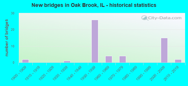
- New bridges - historical statistics
- 21900-1909
- 11930-1939
- 261950-1959
- 41960-1969
- 41970-1979
- 152000-2009
- 22010-2019

- Reconstructed bridges - Historical Statistics
- 11960-1969
- 11970-1979
- 31980-1989
- 01990-1999
- 22000-2009


- Bridge Condition - Deck
- 3.4%Very good
- 51.7%Good
- 34.5%Satisfactory
- 3.4%Fair
- 6.9%Poor

- Bridge Condition - Superstructure
- 17.2%Very good
- 34.5%Good
- 37.9%Satisfactory
- 10.3%Fair

- Bridge Condition - Substructure
- 10.3%Very good
- 48.3%Good
- 37.9%Satisfactory
- 3.4%Fair

- Bridge Condition - Channel
- 20.0%Very good
- 6.7%Good
- 53.3%Satisfactory
- 20.0%Fair

- Bridge Condition - Culverts
- 25.0%Very good
- 25.0%Good
- 50.0%Fair
Find on map >> Show street view
Structure Number: 229901, Location: 0.2 MI E IL 83 (Lat: 41.846967, Lng: -87.943453), Route carried "under" structure: Other road , Year Built: 2009, Structure Length: 0. m, Average Daily Traffic: 56,000 (year 2021), Truck Traffic: 6%, Features Intersected: CERMACK RD, Facility Carried by Structure: I88WB CDRAMP EW TO
Minimum Vertical Clearance: 30+ m (98+ ft), Kilometerpoint: 3.283, Lanes on structure: 2, Lanes under structure: 6, Toll: On toll road, Material/Design: Steel, Design/Construction: Stringer/Multi-beam, Length of Maximum Span: 29.8m (97.8ft)
Find on map >> Show street view
Structure Number: 229905, Location: 2M.E.OF IL-83 (Lat: 41.853331, Lng: -87.929608), Route carried "under" structure: Other road , Year Built: 1958, Structure Length: 0. m, Average Daily Traffic: 16,000 (year 2020), Features Intersected: I-88 E-W Toll Ramp, Facility Carried by Structure: YORK ROAD
Minimum Vertical Clearance: 4.65m (15.26ft), Kilometerpoint: 2.189, Lanes on structure: 4, Lanes under structure: 4, Material/Design: Prestressed concrete, Design/Construction: Stringer/Multi-beam, Length of Maximum Span: 21.6m (70.9ft)
Find on map >> Show street view
Structure Number: 229907, Location: 0.7 MI W IL 83 (Lat: 41.844286, Lng: -87.972300), Route carried "under" structure: Interstate 88, Year Built: 1958, Structure Length: 0. m, Average Daily Traffic: 124,900 (year 2020), Truck Traffic: 15%, Features Intersected: I-88 E-W TOLL RD., Facility Carried by Structure: MIDWEST RD
Minimum Vertical Clearance: 4.95m (16.24ft), Kilometerpoint: 219.235, Lanes on structure: 4, Lanes under structure: 4, Material/Design: Prestressed concrete, Design/Construction: Stringer/Multi-beam, Length of Maximum Span: 20.1m (65.9ft)
Find on map >> Show street view
Structure Number: 229935, Location: 1.0 M.N.22ND.ST. (Lat: 41.861775, Lng: -87.924994), Route carried "under" structure: State highway 38, Year Built: 1958, Structure Length: 0. m, Average Daily Traffic: 50,300 (year 2021), Truck Traffic: 8%, Features Intersected: ILL 38 (ROOSEVELT RD, Facility Carried by Structure: I-88 WB
Minimum Vertical Clearance: 5.03m (16.50ft), Kilometerpoint: 139.961, Lanes on structure: 3, Lanes under structure: 6, Toll: On toll road, Material/Design: Prestressed concrete, Design/Construction: Stringer/Multi-beam, Length of Maximum Span: 25.3m (83.0ft)
Find on map >> Show street view
Structure Number: 229941, Location: 0.2 MI E OF IL 83 (Lat: 41.846981, Lng: -87.942442), Route carried "under" structure: Other road , Year Built: 2009, Structure Length: 0. m, Average Daily Traffic: 56,000 (year 2021), Truck Traffic: 6%, Features Intersected: 22ND ST (CERMAK RD), Facility Carried by Structure: I-88 EB E-W TOLLWA
Minimum Vertical Clearance: 4.62m (15.16ft), Kilometerpoint: 3.380, Lanes on structure: 4, Lanes under structure: 6, Toll: On toll road, Material/Design: Steel, Design/Construction: Stringer/Multi-beam, Length of Maximum Span: 29.8m (97.8ft)
Find on map >> Show street view
Structure Number: 229942, Location: 0.2MI E OF IL 83 (Lat: 41.846967, Lng: -87.943122), Route carried "under" structure: Other road , Year Built: 2009, Structure Length: 0. m, Average Daily Traffic: 56,000 (year 2021), Truck Traffic: 6%, Features Intersected: 22ND ST (CERMAK RD), Facility Carried by Structure: I-88 WB E-W TOLLWA
Minimum Vertical Clearance: 4.62m (15.16ft), Kilometerpoint: 3.315, Lanes on structure: 4, Lanes under structure: 6, Toll: On toll road, Material/Design: Steel, Design/Construction: Stringer/Multi-beam, Length of Maximum Span: 29.8m (97.8ft)
Find on map >> Show street view
Structure Number: 229996, Location: 0.25MI E OF IL 83 (Lat: 41.853422, Lng: -87.932636), Route carried "under" structure: Interstate 88, Year Built: 2008, Structure Length: 0. m, Average Daily Traffic: 95,000 (year 2020), Truck Traffic: 15%, Features Intersected: I-88 & SALT CREEK
Minimum Vertical Clearance: 4.95m (16.24ft), Kilometerpoint: 222.888, Lanes on structure: 2, Lanes under structure: 6, Toll: On toll road, Material/Design: Steel, Design/Construction: Stringer/Multi-beam, Length of Maximum Span: 76.7m (251.6ft)
Find on map >> Show street view
Structure Number: 229998, Location: 1.1M E OF HIGHLAND (Lat: 41.839711, Lng: -87.990711), Route carried "under" structure: Interstate 88, Year Built: 2004, Structure Length: 0. m, Average Daily Traffic: 128,200 (year 2020), Truck Traffic: 15%, Features Intersected: I-88 E-W TOLL RD, Facility Carried by Structure: MEYERS RD
Minimum Vertical Clearance: 5.08m (16.67ft), Kilometerpoint: 217.610, Lanes on structure: 4, Lanes under structure: 5, Material/Design: Steel continuous, Design/Construction: Stringer/Multi-beam, Length of Maximum Span: 39.9m (130.9ft)