Bridge Statistics for Oak Ridge, Tennessee (TN)
Condition, Traffic, Stress, Structural Evaluation, Project Costs
- National Bridge Inventory (NBI) Statistics
- 105Number of bridges
- 1,276ft / 389mTotal length
- $37,313,000Total costs
- 1,032,957Total average daily traffic
- 126,126Total average daily truck traffic
- National Bridge Inventory (NBI) Registered Bridges for Oak Ridge
- No street view available for this location
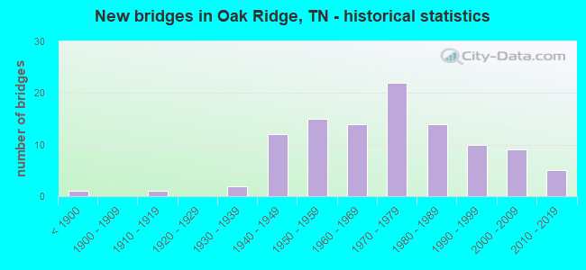
- New bridges - historical statistics
- 1Before 1900
- 11910-1919
- 21930-1939
- 121940-1949
- 151950-1959
- 141960-1969
- 221970-1979
- 141980-1989
- 101990-1999
- 92000-2009
- 52010-2019

- Reconstructed bridges - Historical Statistics
- 11940-1949
- 01950-1959
- 01960-1969
- 01970-1979
- 21980-1989
- 11990-1999
- 12000-2009
- 12010-2019


- Bridge Condition - Deck
- 19.4%Very good
- 33.9%Good
- 38.7%Satisfactory
- 8.1%Fair

- Bridge Condition - Superstructure
- 25.8%Very good
- 32.3%Good
- 32.3%Satisfactory
- 8.1%Fair
- 1.6%Poor

- Bridge Condition - Substructure
- 19.4%Very good
- 32.3%Good
- 32.3%Satisfactory
- 14.5%Fair
- 1.6%Poor

- Bridge Condition - Channel
- 16.4%Very good
- 61.6%Good
- 12.3%Satisfactory
- 9.6%Fair

- Bridge Condition - Culverts
- 8.0%Very good
- 28.0%Good
- 44.0%Satisfactory
- 20.0%Fair
Find on map >> Show street view
Structure Number: 73SR0950003, Location: IN OAK RIDGE (Lat: 35.969967, Lng: -84.346433), Route carried "on" structure: State highway 95, Year Built: 2013, Status: Open, Structure Length: 2.62m (8.60ft), Average Daily Traffic: 13,635 (year 2020), Truck Traffic: 9%, Average Future Daily Traffic: 21,816 (year 2041), Design Load: HL 93, Features Intersected: EAST FORK POPLAR CREEK
Minimum Vertical Clearance: 30+ m (98+ ft), Kilometerpoint: 13.004, Lanes on structure: 2, Base Highway Network: Yes, Owner: State Highway Agency, Approaching Roadway Width: 12.8m (42.0ft), Skew: 10 degrees, Material/Design: Prestressed concrete, Design/Construction: Box Beam or Girders - Single/Spread, Number Of Spans In Main Unit: 1, Length of Maximum Span: 26.2m (86.0ft), Curb-To-Curb Width: 12.8m (42.0ft), Out-to-Out Width: 13.4m (44.0ft)
Condition: Deck: Very good, Superstructure: Very good, Substructure: Very good, Channel: Very good, Operating Rating: 89.1 metric tons, Method Used To Determine Operating Rating: Load Factor (LF), Inventory Rating: 32.4 metric tons, Method Used To Determine Inventory Rating: Load Factor (LF), Structural Evaluation: Equal to present desirable criteria, Deck Geometry: Equal to present desirable criteria, Waterway Adequacy: Equal to present desirable criteria, Approach Roadway Alignment: Equal to present desirable criteria, Designated Inspection Frequency: Every 24 months, Inspection Date: May 2021, Deck Structure Type: Concrete Cast-file-Place, Wearing Surface/Protective System: Deck Protection: Epoxy Coated Reinforcing
Find on map >> Show street view
Structure Number: 73SR0950004, Location: IN OAK RIDGE (Lat: 35.969967, Lng: -84.346433), Route carried "on" structure: State highway 95, Year Built: 2013, Status: Open, Structure Length: 2.62m (8.60ft), Average Daily Traffic: 13,635 (year 2020), Truck Traffic: 9%, Average Future Daily Traffic: 21,816 (year 2041), Design Load: HL 93, Features Intersected: EAST FORK POPLAR CREEK
Minimum Vertical Clearance: 30+ m (98+ ft), Kilometerpoint: 13.004, Lanes on structure: 2, Base Highway Network: Yes, Owner: State Highway Agency, Approaching Roadway Width: 12.8m (42.0ft), Skew: 10 degrees, Material/Design: Prestressed concrete, Design/Construction: Box Beam or Girders - Single/Spread, Number Of Spans In Main Unit: 1, Length of Maximum Span: 26.2m (86.0ft), Curb-To-Curb Width: 12.8m (42.0ft), Out-to-Out Width: 13.4m (44.0ft)
Condition: Deck: Very good, Superstructure: Very good, Substructure: Very good, Channel: Very good, Operating Rating: 89.1 metric tons, Method Used To Determine Operating Rating: Load Factor (LF), Inventory Rating: 32.4 metric tons, Method Used To Determine Inventory Rating: Load Factor (LF), Structural Evaluation: Equal to present desirable criteria, Deck Geometry: Equal to present desirable criteria, Waterway Adequacy: Equal to present desirable criteria, Approach Roadway Alignment: Equal to present desirable criteria, Designated Inspection Frequency: Every 24 months, Inspection Date: May 2021, Deck Structure Type: Concrete Cast-file-Place, Wearing Surface/Protective System: Deck Protection: Epoxy Coated Reinforcing
Find on map >> Show street view
Structure Number: 73SR0950005, Location: NEAR OAK RIDGE (Lat: 35.943817, Lng: -84.357133), Route carried "on" structure: State highway 95, Year Built: 1982, Status: Open, Structure Length: 1.40m (4.59ft), Average Daily Traffic: 7,453 (year 2020), Truck Traffic: 9%, Average Future Daily Traffic: 11,925 (year 2041), Design Load: HS 20, Features Intersected: BEAR CREEK
Minimum Vertical Clearance: 30+ m (98+ ft), Kilometerpoint: 8.739, Lanes on structure: 4, Base Highway Network: Yes, Owner: State Highway Agency, Approaching Roadway Width: 23.2m (76.1ft), Skew: 23 degrees, Material/Design: Concrete continuous, Design/Construction: Culvert, Number Of Spans In Main Unit: 3, Length of Maximum Span: 4.6m (15.1ft)
Condition: Channel: Good, Culverts: Satisfactory, Operating Rating: 89.1 metric tons, Method Used To Determine Operating Rating: Load Factor (LF), Inventory Rating: 32.4 metric tons, Method Used To Determine Inventory Rating: Load Factor (LF), Structural Evaluation: Equal to present minimum criteria, Waterway Adequacy: Better than present minimum criteria, Approach Roadway Alignment: Equal to present desirable criteria, Length Of Structure Improvement: 1.40m (4.59ft), Designated Inspection Frequency: Every 24 months, Inspection Date: May 2021, Bridge Improvement Cost: $438,000, Roadway Improvement Cost: $44,000, Total Project Cost: $658,000 ( Estimate for 2021)
Find on map >> Show street view
Structure Number: 73SR0950007, Location: NORTH OF I40 (Lat: 35.900017, Lng: -84.326183), Route carried "on" structure: State highway 95, Year Built: 1983, Status: Open, Structure Length: 1.37m (4.49ft), Average Daily Traffic: 5,599 (year 2020), Truck Traffic: 9%, Average Future Daily Traffic: 8,958 (year 2041), Design Load: HS 20+Mod, Features Intersected: WHITEOAK CREEK
Minimum Vertical Clearance: 30+ m (98+ ft), Kilometerpoint: 1.513, Lanes on structure: 2, Base Highway Network: Yes, Owner: State Highway Agency, Approaching Roadway Width: 11.6m (38.1ft), Material/Design: Prestressed concrete, Design/Construction: Box Beam or Girders - Multiple, Number Of Spans In Main Unit: 1, Length of Maximum Span: 12.2m (40.0ft), Curb-To-Curb Width: 10.9m (35.8ft), Out-to-Out Width: 12.1m (39.7ft)
Condition: Deck: Good, Superstructure: Good, Substructure: Good, Channel: Very good, Operating Rating: 44.1 metric tons, Method Used To Determine Operating Rating: Assigned rating based on Load Factor Design (LFD) reported in metric tons, Inventory Rating: 32.4 metric tons, Method Used To Determine Inventory Rating: Assigned rating based on Load Factor Design (LFD) reported in metric tons, Structural Evaluation: Better than present minimum criteria, Deck Geometry: Meets minimum limits, Waterway Adequacy: Better than present minimum criteria, Approach Roadway Alignment: Equal to present desirable criteria, Designated Inspection Frequency: Every 24 months, Inspection Date: May 2021, Deck Structure Type: Concrete Cast-file-Place, Wearing Surface/Protective System: Wearing Surface: Bituminous
Find on map >> Show street view
Structure Number: 73SR0950009, Location: AT SR 58 JCT (Lat: 35.944617, Lng: -84.361850), Route carried "on" structure: Ramp State highway 95, Year Built: 1982, Status: Open, Structure Length: 1.01m (3.31ft), Average Daily Traffic: 13,635 (year 2020), Truck Traffic: 9%, Average Future Daily Traffic: 1,392 (year 2041), Design Load: HS 20+Mod, Features Intersected: BEAR CREEK
Minimum Vertical Clearance: 30+ m (98+ ft), Kilometerpoint: 9.495, Lanes on structure: 1, Base Highway Network: Yes, Owner: State Highway Agency, Approaching Roadway Width: 8.8m (28.9ft), Material/Design: Concrete continuous, Design/Construction: Culvert, Number Of Spans In Main Unit: 3, Length of Maximum Span: 3.4m (11.2ft)
Condition: Channel: Good, Culverts: Good, Operating Rating: 89.1 metric tons, Method Used To Determine Operating Rating: Load Factor (LF), Inventory Rating: 32.4 metric tons, Method Used To Determine Inventory Rating: Load Factor (LF), Structural Evaluation: Better than present minimum criteria, Waterway Adequacy: Better than present minimum criteria, Approach Roadway Alignment: Equal to present desirable criteria, Designated Inspection Frequency: Every 24 months, Inspection Date: May 2021
Find on map >> Show street view
Structure Number: 206348, Location: 1.69 km N. of SR 58 (Lat: 35.932319, Lng: -84.405528), Route carried "on" structure: ServiceFederal lands road B130, Year Built: 1998, Status: Open, Structure Length: 8.90m (29.20ft), Average Daily Traffic: 227 (year 2014), Truck Traffic: 13%, Average Future Daily Traffic: 240 (year 2015), Design Load: HS 25 or greater, Features Intersected: Poplar Creek, Facility Carried by Structure: Perimeter Road
Minimum Vertical Clearance: 30+ m (98+ ft), Kilometerpoint: 0.000, Lanes on structure: 2, Owner: DOE, Approaching Roadway Width: 8.5m (27.9ft), Material/Design: Steel continuous, Design/Construction: Stringer/Multi-beam, Number Of Spans In Main Unit: 4, Length of Maximum Span: 24.1m (79.1ft), Curb-To-Curb Width: 8.5m (27.9ft), Out-to-Out Width: 9.2m (30.2ft)
Condition: Deck: Good, Superstructure: Good, Substructure: Satisfactory, Channel: Good, Operating Rating: 28.5 metric tons, Method Used To Determine Operating Rating: Load and Resistance Factor Rating (LRFR) rating reported by rating factor(RF) method using HL-93 loadings, Inventory Rating: 22.0 metric tons, Method Used To Determine Inventory Rating: Load and Resistance Factor Rating (LRFR) rating reported by rating factor(RF) method using HL-93 loadings, Structural Evaluation: Equal to present minimum criteria, Deck Geometry: Equal to present minimum criteria, Waterway Adequacy: Superior to present desirable criteria, Approach Roadway Alignment: Equal to present desirable criteria, Designated Inspection Frequency: Every 24 months, Underwater Inspection Frequency: Every 60 months, Inspection Date: May 2020, Underwater Inspection Date: June 2017, Deck Structure Type: Concrete Cast-file-Place, Wearing Surface/Protective System: Wearing Surface: Monolithic Concrete, Deck Protection: Epoxy Coated Reinforcing
Find on map >> Show street view
Structure Number: 20635, Location: 0.18km E. of SR 95 (Lat: 35.937686, Lng: -84.338394), Route carried "on" structure: ServiceOther road A138, Year Built: 1960, Status: Open, Structure Length: 0.64m (2.10ft), Average Daily Traffic: 690 (year 2013), Truck Traffic: 2%, Average Future Daily Traffic: 633 (year 2030), Features Intersected: Bear Creek, Facility Carried by Structure: Bear Creek Road
Minimum Vertical Clearance: 30+ m (98+ ft), Kilometerpoint: 0.000, Lanes on structure: 1, Owner: DOE, Approaching Roadway Width: 10.1m (33.1ft), Skew: 9 degrees, Material/Design: Concrete, Design/Construction: Culvert, Number Of Spans In Main Unit: 2, Length of Maximum Span: 3.0m (9.8ft), Curb-To-Curb Width: 10.1m (33.1ft), Out-to-Out Width: 13.1m (43.0ft)
Condition: Channel: Good, Culverts: Good, Operating Rating: 32.4 metric tons, Method Used To Determine Operating Rating: No rating analysis performed, Inventory Rating: 32.4 metric tons, Method Used To Determine Inventory Rating: No rating analysis performed, Structural Evaluation: Better than present minimum criteria, Deck Geometry: Equal to present minimum criteria, Waterway Adequacy: Superior to present desirable criteria, Approach Roadway Alignment: Equal to present desirable criteria, Designated Inspection Frequency: Every 24 months, Inspection Date: September 2021
Find on map >> Show street view
Structure Number: 1024440007, Location: 1 M NW OF SR61-SR95 JCT (Lat: 36.068417, Lng: -84.219250), Route carried "under" structure: County highway 2444, Year Built: 1950, Structure Length: 0. m, Average Daily Traffic: 853 (year 2020), Truck Traffic: 3%, Features Intersected: NORFOLK-SOUTHERN RR
Minimum Vertical Clearance: 3.26m (10.70ft), Kilometerpoint: 11.523, Lanes under structure: 1, Material/Design: Wood or Timber, Design/Construction: Stringer/Multi-beam, Length of Maximum Span: 4.3m (14.1ft)
Find on map >> Show street view
Structure Number: 10A3590001, Location: E OFF SR95 AT OAK RIDGE (Lat: 36.050250, Lng: -84.205000), Route carried "under" structure: City street 359, Year Built: 1950, Structure Length: 0. m, Average Daily Traffic: 400 (year 2022), Truck Traffic: 2%, Features Intersected: CSX RAILROAD, Facility Carried by Structure: CSX RR 347527T
Minimum Vertical Clearance: 3.54m (11.61ft), Kilometerpoint: 0.916, Lanes under structure: 2, Material/Design: Steel, Design/Construction: Stringer/Multi-beam, Length of Maximum Span: 7.9m (25.9ft)
Find on map >> Show street view
Structure Number: 1SR0610011, Location: NEAR CLINTON TENN. (Lat: 36.129200, Lng: -84.224633), Route carried "under" structure: State highway 61, Year Built: 1946, Structure Length: 0. m, Average Daily Traffic: 4,050 (year 2020), Truck Traffic: 3%, Features Intersected: CSX RAILROAD, Facility Carried by Structure: CSX RR 347525E
Minimum Vertical Clearance: 4.38m (14.37ft), Kilometerpoint: 13.583, Lanes under structure: 2, Material/Design: Steel, Design/Construction: Stringer/Multi-beam, Length of Maximum Span: 11.0m (36.1ft)
Find on map >> Show street view
Structure Number: 1SR0620003, Location: N. OF CLINCH OF RIVER (Lat: 35.992100, Lng: -84.199517), Route carried "under" structure: State highway 170, Year Built: 1979, Structure Length: 0. m, Average Daily Traffic: 17,421 (year 2020), Truck Traffic: 6%, Features Intersected: SR 62 RT LN, Facility Carried by Structure: FAP 62
Minimum Vertical Clearance: 5.08m (16.67ft), Kilometerpoint: 0.000, Lanes on structure: 2, Lanes under structure: 2, Material/Design: Prestressed concrete continuous, Design/Construction: Box Beam or Girders - Single/Spread, Length of Maximum Span: 37.3m (122.4ft)
Find on map >> Show street view
Structure Number: 1SR0620004, Location: N. OF CLINCH RIVER (Lat: 35.992067, Lng: -84.199183), Route carried "under" structure: State highway 170, Year Built: 1979, Structure Length: 0. m, Average Daily Traffic: 17,421 (year 2020), Truck Traffic: 6%, Features Intersected: SR 62 LF LN, Facility Carried by Structure: FAP 62
Minimum Vertical Clearance: 6.17m (20.24ft), Kilometerpoint: 0.016, Lanes on structure: 2, Lanes under structure: 2, Material/Design: Prestressed concrete continuous, Design/Construction: Box Beam or Girders - Single/Spread, Length of Maximum Span: 36.1m (118.4ft)
Find on map >> Show street view
Structure Number: 1SR0620005, Location: IN OAK RIDGE (Lat: 36.003950, Lng: -84.231483), Route carried "under" structure: State highway 62, Year Built: 1981, Structure Length: 0. m, Average Daily Traffic: 42,528 (year 2020), Truck Traffic: 9%, Features Intersected: NFA E493, Facility Carried by Structure: NFA E493
Minimum Vertical Clearance: 5.14m (16.86ft), Kilometerpoint: 7.194, Lanes on structure: 2, Lanes under structure: 3, Material/Design: Prestressed concrete, Design/Construction: Box Beam or Girders - Single/Spread, Length of Maximum Span: 32.9m (107.9ft)
Find on map >> Show street view
Structure Number: 1SR0620011, Location: IN OAK RIDGE (Lat: 35.987550, Lng: -84.215817), Route carried "under" structure: City street 5391, Year Built: 2000, Structure Length: 0. m, Average Daily Traffic: 6,390 (year 2020), Truck Traffic: 4%, Features Intersected: FAU 5391, Facility Carried by Structure: FAP 62
Minimum Vertical Clearance: 5.47m (17.95ft), Kilometerpoint: 0.772, Lanes on structure: 4, Lanes under structure: 3, Material/Design: Prestressed concrete, Design/Construction: Stringer/Multi-beam, Length of Maximum Span: 29.4m (96.5ft)
Find on map >> Show street view
Structure Number: 1SR0950007, Location: NEAR OAK RIDGE TN (Lat: 36.050383, Lng: -84.206883), Route carried "under" structure: State highway 95, Year Built: 1950, Structure Length: 0. m, Average Daily Traffic: 22,328 (year 2020), Truck Traffic: 9%, Features Intersected: CSX RAILROAD, Facility Carried by Structure: CSX RR 347526L
Minimum Vertical Clearance: 4.48m (14.70ft), Kilometerpoint: 12.641, Lanes under structure: 4, Material/Design: Steel, Design/Construction: Stringer/Multi-beam, Length of Maximum Span: 12.5m (41.0ft)
Find on map >> Show street view
Structure Number: 47SR0620001, Location: 1.4 SE OF ANDERSON CO LI (Lat: 35.978150, Lng: -84.178550), Route carried "under" structure: State highway 62, Year Built: 1973, Structure Length: 0. m, Average Daily Traffic: 9,865 (year 2020), Truck Traffic: 9%, Features Intersected: SR 162 / SR62 EBL
Minimum Vertical Clearance: 4.88m (16.01ft), Kilometerpoint: 2.189, Lanes on structure: 2, Lanes under structure: 2, Material/Design: Concrete continuous, Design/Construction: Box Beam or Girders - Multiple, Length of Maximum Span: 30.5m (100.1ft)
Find on map >> Show street view
Structure Number: 53I00400007, Location: 5.5 M. N. LENOIR CITY (Lat: 35.868400, Lng: -84.300217), Route carried "under" structure: County highway 5896, Year Built: 1959, Structure Length: 0. m, Average Daily Traffic: 287 (year 2020), Truck Traffic: 3%, Features Intersected: I40 RT LN, Facility Carried by Structure: I40 RL
Minimum Vertical Clearance: 5.77m (18.93ft), Kilometerpoint: 2.921, Lanes on structure: 2, Lanes under structure: 2, Material/Design: Concrete continuous, Design/Construction: Tee Beam, Length of Maximum Span: 16.8m (55.1ft)
Find on map >> Show street view
Structure Number: 53I00400008, Location: 5.5 M. N. LENOIR CITY (Lat: 35.868683, Lng: -84.300383), Route carried "under" structure: County highway 5896, Year Built: 1959, Structure Length: 0. m, Average Daily Traffic: 287 (year 2020), Truck Traffic: 3%, Features Intersected: I40 LF LN, Facility Carried by Structure: I40 LL
Minimum Vertical Clearance: 5.21m (17.09ft), Kilometerpoint: 2.902, Lanes on structure: 2, Lanes under structure: 2, Material/Design: Concrete continuous, Design/Construction: Tee Beam, Length of Maximum Span: 16.8m (55.1ft)
Find on map >> Show street view
Structure Number: 53I00400009, Location: NEAR OAK RIDGE (Lat: 35.870850, Lng: -84.275700), Route carried "under" structure: Interstate 40, Year Built: 1958, Structure Length: 0. m, Average Daily Traffic: 38,851 (year 2020), Truck Traffic: 23%, Features Intersected: NFA C131, Facility Carried by Structure: NFA C131
Minimum Vertical Clearance: 4.68m (15.35ft), Kilometerpoint: 5.504, Lanes on structure: 2, Lanes under structure: 4, Material/Design: Concrete continuous, Design/Construction: Tee Beam, Length of Maximum Span: 21.3m (69.9ft)
Find on map >> Show street view
Structure Number: 73I00400029, Location: 3 MI W FROM LOUDON CO LN (Lat: 35.866350, Lng: -84.386900), Route carried "under" structure: Interstate 40, Year Built: 1959, Structure Length: 0. m, Average Daily Traffic: 41,028 (year 2020), Truck Traffic: 23%, Features Intersected: EBLEN COVE ROAD-A321/I40, Facility Carried by Structure: NFA A321
Minimum Vertical Clearance: 4.82m (15.81ft), Kilometerpoint: 31.720, Lanes on structure: 2, Lanes under structure: 4, Material/Design: Concrete continuous, Design/Construction: Tee Beam, Length of Maximum Span: 20.1m (65.9ft)
Find on map >> Show street view
Structure Number: 73I00400031, Location: 2 MI W FROM LOUDON CO LN (Lat: 35.871433, Lng: -84.376467), Route carried "under" structure: Interstate 40, Year Built: 1960, Structure Length: 0. m, Average Daily Traffic: 41,812 (year 2020), Truck Traffic: 23%, Features Intersected: NFA 2366/I40, Facility Carried by Structure: NFA 2366
Minimum Vertical Clearance: 4.50m (14.76ft), Kilometerpoint: 32.831, Lanes on structure: 2, Lanes under structure: 4, Material/Design: Concrete continuous, Design/Construction: Tee Beam, Length of Maximum Span: 23.2m (76.1ft)
Find on map >> Show street view
Structure Number: 73I00400035, Location: 1.3 MI W FROM LOUDON CO L (Lat: 35.878317, Lng: -84.360533), Route carried "under" structure: Interstate 40, Year Built: 2008, Structure Length: 0. m, Average Daily Traffic: 39,707 (year 2020), Truck Traffic: 23%, Features Intersected: NFA 2366/I40, Facility Carried by Structure: NFA 2366
Minimum Vertical Clearance: 5.74m (18.83ft), Kilometerpoint: 34.424, Lanes on structure: 2, Lanes under structure: 4, Material/Design: Steel continuous, Design/Construction: Stringer/Multi-beam, Length of Maximum Span: 20.1m (65.9ft)
Find on map >> Show street view
Structure Number: 73SR0580011, Location: IN OAK RIDGE (Lat: 35.943467, Lng: -84.364250), Route carried "under" structure: State highway 58, Year Built: 1982, Structure Length: 0. m, Average Daily Traffic: 14,944 (year 2020), Truck Traffic: 9%, Features Intersected: SR-95 / SR-58, Facility Carried by Structure: FAP 95
Minimum Vertical Clearance: 4.96m (16.27ft), Kilometerpoint: 33.394, Lanes on structure: 4, Lanes under structure: 4, Material/Design: Prestressed concrete continuous, Design/Construction: Box Beam or Girders - Single/Spread, Length of Maximum Span: 27.1m (88.9ft)
Find on map >> Show street view
Structure Number: 73SR0580013, Location: IN OAK RIDGE (Lat: 35.931367, Lng: -84.376017), Route carried "under" structure: State highway 58, Year Built: 2006, Structure Length: 0. m, Average Daily Traffic: 12,924 (year 2020), Truck Traffic: 9%, Features Intersected: DOE ACCESS RD/SR 58
Minimum Vertical Clearance: 5.11m (16.77ft), Kilometerpoint: 31.736, Lanes on structure: 2, Lanes under structure: 4, Material/Design: Steel, Design/Construction: Truss - Deck, Length of Maximum Span: 36.0m (118.1ft)
Find on map >> Show street view
Structure Number: 73SR0950011, Location: IN OAK RIDGE (Lat: 35.988667, Lng: -84.340717), Route carried "under" structure: State highway 95, Year Built: 2006, Structure Length: 0. m, Average Daily Traffic: 7,453 (year 2020), Truck Traffic: 9%, Features Intersected: DOE ACCESS RD/SR 58, Facility Carried by Structure: FAP 58
Minimum Vertical Clearance: 5.18m (16.99ft), Kilometerpoint: 6.904, Lanes on structure: 2, Lanes under structure: 2, Material/Design: Steel, Design/Construction: Truss - Deck, Length of Maximum Span: 21.9m (71.9ft)