Bridge Statistics for Omaha, Nebraska (NE)
Condition, Traffic, Stress, Structural Evaluation, Project Costs
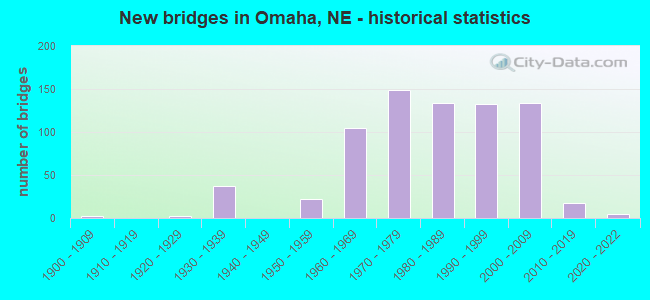
- New bridges - historical statistics
- 21900-1909
- 21920-1929
- 371930-1939
- 221950-1959
- 1051960-1969
- 1491970-1979
- 1341980-1989
- 1321990-1999
- 1342000-2009
- 182010-2019
- 52020-2022
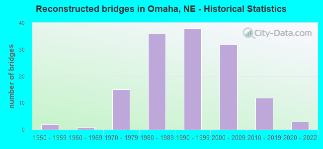
- Reconstructed bridges - Historical Statistics
- 21950-1959
- 11960-1969
- 151970-1979
- 361980-1989
- 381990-1999
- 322000-2009
- 122010-2019
- 32020-2022
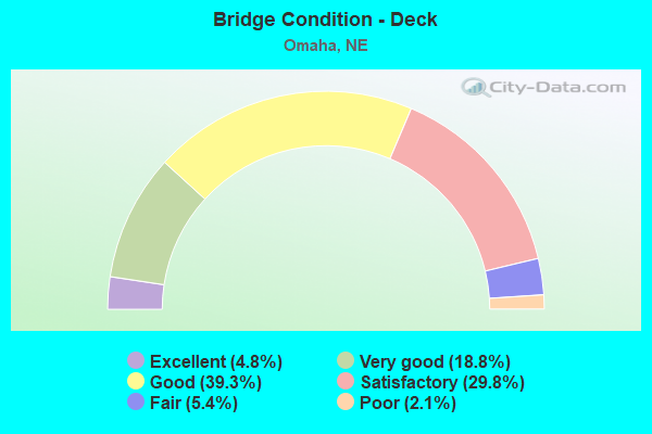
- Bridge Condition - Deck
- 4.8%Excellent
- 18.8%Very good
- 39.3%Good
- 29.8%Satisfactory
- 5.4%Fair
- 2.1%Poor
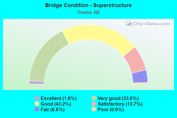
- Bridge Condition - Superstructure
- 1.8%Excellent
- 33.6%Very good
- 43.2%Good
- 13.7%Satisfactory
- 6.8%Fair
- 0.9%Poor
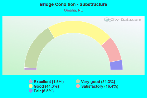
- Bridge Condition - Substructure
- 1.5%Excellent
- 31.3%Very good
- 44.3%Good
- 16.4%Satisfactory
- 6.5%Fair
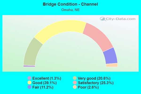
- Bridge Condition - Channel
- 1.3%Excellent
- 20.6%Very good
- 39.1%Good
- 25.3%Satisfactory
- 11.2%Fair
- 2.6%Poor
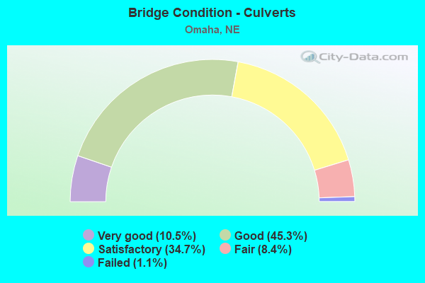
- Bridge Condition - Culverts
- 10.5%Very good
- 45.3%Good
- 34.7%Satisfactory
- 8.4%Fair
- 1.1%Failed
Find on map >> Show street view
Structure Number: S480 00131, Location: IN OMAHA (Lat: 41.245300, Lng: -95.953600), Route carried "under" structure: Interstate 480, Year Built: 1962, Structure Length: 0. m, Average Daily Traffic: 105,000 (year 2013), Truck Traffic: 5%, Features Intersected: I480/US75, Facility Carried by Structure: WOOLWORTH AVE/FAU
Minimum Vertical Clearance: 7.97m (26.15ft), Kilometerpoint: 0.211, Lanes on structure: 6, Lanes under structure: 6, Material/Design: Concrete continuous, Design/Construction: Box Beam or Girders - Multiple, Length of Maximum Span: 22.6m (74.1ft)
Find on map >> Show street view
Structure Number: S480 0018, Location: LEAVENWORTH ST INTRCHG (Lat: 41.252400, Lng: -95.953800), Route carried "under" structure: Interstate 480, Year Built: 1962, Structure Length: 0. m, Average Daily Traffic: 89,290 (year 2013), Truck Traffic: 5%, Features Intersected: I480/US75, Facility Carried by Structure: LEAVENWORTH ST/FAU
Minimum Vertical Clearance: 4.97m (16.31ft), Kilometerpoint: 0.290, Lanes on structure: 6, Lanes under structure: 6, Material/Design: Concrete continuous, Design/Construction: Box Beam or Girders - Multiple, Length of Maximum Span: 22.6m (74.1ft)
Find on map >> Show street view
Structure Number: S480 00188, Location: IN OMAHA (Lat: 41.253600, Lng: -95.953700), Route carried "under" structure: Interstate 480, Year Built: 1962, Structure Length: 0. m, Average Daily Traffic: 89,290 (year 2013), Truck Traffic: 5%, Features Intersected: I480/US75, Facility Carried by Structure: ST MARYS AVE
Minimum Vertical Clearance: 4.72m (15.49ft), Kilometerpoint: 0.303, Lanes on structure: 6, Lanes under structure: 6, Material/Design: Concrete continuous, Design/Construction: Box Beam or Girders - Multiple, Length of Maximum Span: 24.4m (80.1ft)
Find on map >> Show street view
Structure Number: S480 00209, Location: HARNEY ST INTRCHG (Lat: 41.256700, Lng: -95.953800), Route carried "under" structure: Interstate 480, Year Built: 1963, Structure Length: 0. m, Average Daily Traffic: 72,835 (year 2013), Truck Traffic: 5%, Features Intersected: I480/US75, Facility Carried by Structure: HARNEY ST/FAU 5050
Minimum Vertical Clearance: 5.18m (16.99ft), Kilometerpoint: 0.336, Lanes on structure: 6, Lanes under structure: 6, Material/Design: Concrete continuous, Design/Construction: Box Beam or Girders - Multiple, Length of Maximum Span: 22.6m (74.1ft)
Find on map >> Show street view
Structure Number: S480 00216, Location: IN OMAHA (Lat: 41.257700, Lng: -95.953800), Route carried "under" structure: Interstate 480, Year Built: 1963, Structure Length: 0. m, Average Daily Traffic: 72,835 (year 2013), Truck Traffic: 5%, Features Intersected: I480/US75, Facility Carried by Structure: FARNAM ST/FAU 5052
Minimum Vertical Clearance: 4.82m (15.81ft), Kilometerpoint: 0.348, Lanes on structure: 6, Lanes under structure: 6, Material/Design: Concrete continuous, Design/Construction: Box Beam or Girders - Multiple, Length of Maximum Span: 25.0m (82.0ft)
Find on map >> Show street view
Structure Number: S480 00224, Location: IN OMAHA (Lat: 41.258800, Lng: -95.953700), Route carried "under" structure: Interstate 480, Year Built: 1964, Structure Length: 0. m, Average Daily Traffic: 72,835 (year 2013), Truck Traffic: 5%, Features Intersected: I480/US75, Facility Carried by Structure: EB-US6/DOUGLAS ST
Minimum Vertical Clearance: 4.82m (15.81ft), Kilometerpoint: 0.360, Lanes on structure: 4, Lanes under structure: 4, Material/Design: Concrete continuous, Design/Construction: Box Beam or Girders - Multiple, Length of Maximum Span: 34.1m (111.9ft)
Find on map >> Show street view
Structure Number: S480 00231, Location: IN OMAHA (Lat: 41.259800, Lng: -95.953800), Route carried "under" structure: US 75, Year Built: 1964, Structure Length: 0. m, Average Daily Traffic: 121,145 (year 2006), Features Intersected: I480/US75, Facility Carried by Structure: WB-US6/DODGE ST
Minimum Vertical Clearance: 4.90m (16.08ft), Kilometerpoint: 59.824, Lanes on structure: 12, Lanes under structure: 12, Material/Design: Steel continuous, Design/Construction: Stringer/Multi-beam, Length of Maximum Span: 71.9m (235.9ft)
Find on map >> Show street view
Structure Number: S480 00231, Location: IN OMAHA (Lat: 41.259800, Lng: -95.953800), Route carried "under" structure: Ramp US 480, Year Built: 1964, Structure Length: 0. m, Average Daily Traffic: 121,145 (year 2006), Features Intersected: I480/US75, Facility Carried by Structure: WB-US6/DODGE ST
Minimum Vertical Clearance: 4.90m (16.08ft), Kilometerpoint: 59.824, Lanes on structure: 12, Lanes under structure: 12, Material/Design: Steel continuous, Design/Construction: Stringer/Multi-beam, Length of Maximum Span: 71.9m (235.9ft)
Find on map >> Show street view
Structure Number: S480 00231, Location: IN OMAHA (Lat: 41.259800, Lng: -95.953800), Route carried "under" structure: US 480, Year Built: 1964, Structure Length: 0. m, Average Daily Traffic: 121,145 (year 2006), Features Intersected: I480/US75, Facility Carried by Structure: WB-US6/DODGE ST
Minimum Vertical Clearance: 4.90m (16.08ft), Kilometerpoint: 59.824, Lanes on structure: 12, Lanes under structure: 12, Material/Design: Steel continuous, Design/Construction: Stringer/Multi-beam, Length of Maximum Span: 71.9m (235.9ft)
Find on map >> Show street view
Structure Number: S480 00247A, Location: 28TH & DODGE INTRCHG (Lat: 41.262700, Lng: -95.952000), Route carried "under" structure: US 480, Year Built: 2005, Structure Length: 0. m, Average Daily Traffic: 121,145 (year 2006), Features Intersected: T480/US75/RAMPS
Minimum Vertical Clearance: 4.49m (14.73ft), Kilometerpoint: 14.593, Lanes on structure: 3, Lanes under structure: 3, Material/Design: Steel continuous, Design/Construction: Stringer/Multi-beam, Length of Maximum Span: 58.8m (192.9ft)
Find on map >> Show street view
Structure Number: S480 00247A, Location: 28TH & DODGE INTRCHG (Lat: 41.262700, Lng: -95.952000), Route carried "under" structure: US 75, Year Built: 2005, Structure Length: 0. m, Average Daily Traffic: 121,145 (year 2006), Features Intersected: T480/US75/RAMPS
Minimum Vertical Clearance: 4.49m (14.73ft), Kilometerpoint: 14.593, Lanes on structure: 3, Lanes under structure: 3, Material/Design: Steel continuous, Design/Construction: Stringer/Multi-beam, Length of Maximum Span: 58.8m (192.9ft)
Find on map >> Show street view
Structure Number: S480 00273L, Location: IN OMAHA (Lat: 41.263300, Lng: -95.946900), Route carried "under" structure: County highway 5083, Year Built: 2009, Structure Length: 0. m, Average Daily Traffic: 4,000 (year 2007), Features Intersected: 23RD/24TH FAU5083/5085, Facility Carried by Structure: WB-I480
Minimum Vertical Clearance: 4.90m (16.08ft), Kilometerpoint: 0.687, Lanes on structure: 4, Lanes under structure: 4, Material/Design: Prestressed concrete continuous, Design/Construction: Tee Beam, Length of Maximum Span: 15.8m (51.8ft)
Find on map >> Show street view
Structure Number: S480 00273L, Location: IN OMAHA (Lat: 41.263300, Lng: -95.946900), Route carried "under" structure: County highway 5085, Year Built: 2009, Structure Length: 0. m, Average Daily Traffic: 4,000 (year 2007), Features Intersected: 23RD/24TH FAU5083/5085, Facility Carried by Structure: WB-I480
Minimum Vertical Clearance: 4.90m (16.08ft), Kilometerpoint: 0.687, Lanes on structure: 4, Lanes under structure: 4, Material/Design: Prestressed concrete continuous, Design/Construction: Tee Beam, Length of Maximum Span: 15.8m (51.8ft)
Find on map >> Show street view
Structure Number: S480 00273R, Location: IN OMAHA (Lat: 41.263200, Lng: -95.946900), Route carried "under" structure: City street 5083, Year Built: 2007, Structure Length: 0. m, Average Daily Traffic: 4,000 (year 2007), Features Intersected: 23RD/24TH FAU5083/5085, Facility Carried by Structure: EB-I480
Minimum Vertical Clearance: 6.42m (21.06ft), Kilometerpoint: 0.687, Lanes on structure: 4, Lanes under structure: 4, Material/Design: Prestressed concrete continuous, Design/Construction: Tee Beam, Length of Maximum Span: 15.8m (51.8ft)
Find on map >> Show street view
Structure Number: S480 00273R, Location: IN OMAHA (Lat: 41.263200, Lng: -95.946900), Route carried "under" structure: City street 5083, Year Built: 2007, Structure Length: 0. m, Average Daily Traffic: 4,000 (year 2007), Features Intersected: 23RD/24TH FAU5083/5085, Facility Carried by Structure: EB-I480
Minimum Vertical Clearance: 6.42m (21.06ft), Kilometerpoint: 0.684, Lanes on structure: 4, Lanes under structure: 4, Material/Design: Prestressed concrete continuous, Design/Construction: Tee Beam, Length of Maximum Span: 15.8m (51.8ft)
Find on map >> Show street view
Structure Number: S480 00310A, Location: IN OMAHA (Lat: 41.262400, Lng: -95.942000), Route carried "under" structure: City street 5056, Year Built: 1970, Structure Length: 0. m, Average Daily Traffic: 1,800 (year 2003), Features Intersected: CHICAGO/DAVENPORT/20TH, Facility Carried by Structure: I480/20TH ST EXIT
Minimum Vertical Clearance: 4.90m (16.08ft), Kilometerpoint: 0.056, Lanes on structure: 7, Lanes under structure: 7, Material/Design: Steel continuous, Design/Construction: Box Beam or Girders - Single/Spread, Length of Maximum Span: 21.9m (71.9ft)
Find on map >> Show street view
Structure Number: S480 00310A, Location: IN OMAHA (Lat: 41.262400, Lng: -95.942000), Route carried "under" structure: Interstate 5056, Year Built: 1970, Structure Length: 0. m, Average Daily Traffic: 1,800 (year 2003), Features Intersected: CHICAGO/DAVENPORT/20TH, Facility Carried by Structure: I480/20TH ST EXIT
Minimum Vertical Clearance: 4.90m (16.08ft), Kilometerpoint: 0.499, Lanes on structure: 7, Lanes under structure: 7, Material/Design: Steel continuous, Design/Construction: Box Beam or Girders - Single/Spread, Length of Maximum Span: 21.9m (71.9ft)
Find on map >> Show street view
Structure Number: S480 00310A, Location: IN OMAHA (Lat: 41.262400, Lng: -95.942000), Route carried "under" structure: City street 5089, Year Built: 1970, Structure Length: 0. m, Average Daily Traffic: 1,800 (year 2003), Features Intersected: CHICAGO/DAVENPORT/20TH, Facility Carried by Structure: I480/20TH ST EXIT
Minimum Vertical Clearance: 4.90m (16.08ft), Kilometerpoint: 0.732, Lanes on structure: 7, Lanes under structure: 7, Material/Design: Steel continuous, Design/Construction: Box Beam or Girders - Single/Spread, Length of Maximum Span: 21.9m (71.9ft)
Find on map >> Show street view
Structure Number: S480 00310B, Location: IN OMAHA (Lat: 41.263500, Lng: -95.940700), Route carried "under" structure: City street 5091, Year Built: 1970, Structure Length: 0. m, Average Daily Traffic: 1,800 (year 2003), Features Intersected: 19TH, 20TH, Facility Carried by Structure: I480/17TH ST ACCES
Minimum Vertical Clearance: 5.43m (17.81ft), Kilometerpoint: 0.151, Lanes on structure: 7, Lanes under structure: 7, Material/Design: Steel continuous, Design/Construction: Box Beam or Girders - Single/Spread, Length of Maximum Span: 40.2m (131.9ft)
Find on map >> Show street view
Structure Number: S480 00310B, Location: IN OMAHA (Lat: 41.263500, Lng: -95.940700), Route carried "under" structure: City street 5089, Year Built: 1970, Structure Length: 0. m, Average Daily Traffic: 1,800 (year 2003), Features Intersected: 19TH, 20TH, Facility Carried by Structure: I480/17TH ST ACCES
Minimum Vertical Clearance: 5.43m (17.81ft), Kilometerpoint: 0.735, Lanes on structure: 7, Lanes under structure: 7, Material/Design: Steel continuous, Design/Construction: Box Beam or Girders - Single/Spread, Length of Maximum Span: 40.2m (131.9ft)
Find on map >> Show street view
Structure Number: S480 00310B, Location: IN OMAHA (Lat: 41.263500, Lng: -95.940700), Route carried "under" structure: City street F55, Year Built: 1970, Structure Length: 0. m, Average Daily Traffic: 1,800 (year 2003), Features Intersected: 19TH, 20TH, Facility Carried by Structure: I480/17TH ST ACCES
Minimum Vertical Clearance: 5.43m (17.81ft), Kilometerpoint: 0.499, Lanes on structure: 7, Lanes under structure: 7, Material/Design: Steel continuous, Design/Construction: Box Beam or Girders - Single/Spread, Length of Maximum Span: 40.2m (131.9ft)
Find on map >> Show street view
Structure Number: S480 00310L, Location: IN OMAHA (Lat: 41.263594, Lng: -95.939803), Route carried "under" structure: City street 5095, Year Built: 1970, Structure Length: 0. m, Average Daily Traffic: 2,700 (year 2007), Features Intersected: 20TH THRU 16TH, Facility Carried by Structure: WB-I480
Minimum Vertical Clearance: 4.95m (16.24ft), Kilometerpoint: 0.499, Lanes on structure: 16, Lanes under structure: 16, Material/Design: Steel continuous, Design/Construction: Box Beam or Girders - Multiple, Length of Maximum Span: 41.1m (134.8ft)
Find on map >> Show street view
Structure Number: S480 00310L, Location: IN OMAHA (Lat: 41.263594, Lng: -95.939803), Route carried "under" structure: City street 5093, Year Built: 1970, Structure Length: 0. m, Average Daily Traffic: 2,700 (year 2007), Features Intersected: 20TH THRU 16TH, Facility Carried by Structure: WB-I480
Minimum Vertical Clearance: 4.95m (16.24ft), Kilometerpoint: 0.499, Lanes on structure: 16, Lanes under structure: 16, Material/Design: Steel continuous, Design/Construction: Box Beam or Girders - Multiple, Length of Maximum Span: 41.1m (134.8ft)
Find on map >> Show street view
Structure Number: S480 00310L, Location: IN OMAHA (Lat: 41.263594, Lng: -95.939803), Route carried "under" structure: Ramp City street 480, Year Built: 1970, Structure Length: 0. m, Average Daily Traffic: 6,600 (year 2007), Features Intersected: 20TH THRU 16TH
Minimum Vertical Clearance: 4.95m (16.24ft), Kilometerpoint: 0.499, Lanes on structure: 16, Lanes under structure: 16, Material/Design: Steel continuous, Design/Construction: Box Beam or Girders - Multiple, Length of Maximum Span: 41.1m (134.8ft)
Find on map >> Show street view
Structure Number: S480 00310L, Location: IN OMAHA (Lat: 41.263594, Lng: -95.939803), Route carried "under" structure: City street F55, Year Built: 1970, Structure Length: 0. m, Average Daily Traffic: 2,700 (year 2007), Features Intersected: 20TH THRU 16TH, Facility Carried by Structure: WB-I480
Minimum Vertical Clearance: 4.95m (16.24ft), Kilometerpoint: 0.499, Lanes on structure: 16, Lanes under structure: 16, Material/Design: Steel continuous, Design/Construction: Box Beam or Girders - Multiple, Length of Maximum Span: 41.1m (134.8ft)
Find on map >> Show street view
Structure Number: S480 00310L, Location: IN OMAHA (Lat: 41.263594, Lng: -95.939803), Route carried "under" structure: City street 5091, Year Built: 1970, Structure Length: 0. m, Average Daily Traffic: 2,700 (year 2007), Features Intersected: 20TH THRU 16TH, Facility Carried by Structure: WB-I480
Minimum Vertical Clearance: 4.95m (16.24ft), Kilometerpoint: 0.499, Lanes on structure: 16, Lanes under structure: 16, Material/Design: Steel continuous, Design/Construction: Box Beam or Girders - Multiple, Length of Maximum Span: 41.1m (134.8ft)
Find on map >> Show street view
Structure Number: S480 00310L, Location: IN OMAHA (Lat: 41.263594, Lng: -95.939803), Route carried "under" structure: City street 5089, Year Built: 1970, Structure Length: 0. m, Average Daily Traffic: 2,700 (year 2007), Features Intersected: 20TH THRU 16TH, Facility Carried by Structure: WB-I480
Minimum Vertical Clearance: 4.95m (16.24ft), Kilometerpoint: 0.499, Lanes on structure: 16, Lanes under structure: 16, Material/Design: Steel continuous, Design/Construction: Box Beam or Girders - Multiple, Length of Maximum Span: 41.1m (134.8ft)
Find on map >> Show street view
Structure Number: S480 00310R, Location: IN OMAHA (Lat: 41.263000, Lng: -95.939800), Route carried "under" structure: City street 5095, Year Built: 1970, Structure Length: 0. m, Average Daily Traffic: 2,700 (year 2007), Features Intersected: 20TH THRU 16TH, Facility Carried by Structure: EB-I480
Minimum Vertical Clearance: 6.09m (19.98ft), Kilometerpoint: 0.499, Lanes on structure: 16, Lanes under structure: 16, Material/Design: Steel continuous, Design/Construction: Box Beam or Girders - Multiple, Length of Maximum Span: 39.6m (129.9ft)
Find on map >> Show street view
Structure Number: S480 00310R, Location: IN OMAHA (Lat: 41.263000, Lng: -95.939800), Route carried "under" structure: City street 5093, Year Built: 1970, Structure Length: 0. m, Average Daily Traffic: 2,700 (year 2007), Features Intersected: 20TH THRU 16TH, Facility Carried by Structure: EB-I480
Minimum Vertical Clearance: 6.09m (19.98ft), Kilometerpoint: 0.499, Lanes on structure: 16, Lanes under structure: 16, Material/Design: Steel continuous, Design/Construction: Box Beam or Girders - Multiple, Length of Maximum Span: 39.6m (129.9ft)
Find on map >> Show street view
Structure Number: S480 00310R, Location: IN OMAHA (Lat: 41.263000, Lng: -95.939800), Route carried "under" structure: Ramp City street 480, Year Built: 1970, Structure Length: 0. m, Average Daily Traffic: 6,600 (year 2007), Features Intersected: 20TH THRU 16TH
Minimum Vertical Clearance: 6.09m (19.98ft), Kilometerpoint: 0.499, Lanes on structure: 16, Lanes under structure: 16, Material/Design: Steel continuous, Design/Construction: Box Beam or Girders - Multiple, Length of Maximum Span: 39.6m (129.9ft)
Find on map >> Show street view
Structure Number: S480 00310R, Location: IN OMAHA (Lat: 41.263000, Lng: -95.939800), Route carried "under" structure: City street 5091, Year Built: 1970, Structure Length: 0. m, Average Daily Traffic: 2,700 (year 2007), Features Intersected: 20TH THRU 16TH, Facility Carried by Structure: EB-I480
Minimum Vertical Clearance: 6.09m (19.98ft), Kilometerpoint: 0.499, Lanes on structure: 16, Lanes under structure: 16, Material/Design: Steel continuous, Design/Construction: Box Beam or Girders - Multiple, Length of Maximum Span: 39.6m (129.9ft)
Find on map >> Show street view
Structure Number: S480 00310R, Location: IN OMAHA (Lat: 41.263000, Lng: -95.939800), Route carried "under" structure: City street 5089, Year Built: 1970, Structure Length: 0. m, Average Daily Traffic: 2,700 (year 2007), Features Intersected: 20TH THRU 16TH, Facility Carried by Structure: EB-I480
Minimum Vertical Clearance: 6.09m (19.98ft), Kilometerpoint: 0.499, Lanes on structure: 16, Lanes under structure: 16, Material/Design: Steel continuous, Design/Construction: Box Beam or Girders - Multiple, Length of Maximum Span: 39.6m (129.9ft)
Find on map >> Show street view
Structure Number: S480 00310R, Location: IN OMAHA (Lat: 41.263000, Lng: -95.939800), Route carried "under" structure: City street F55, Year Built: 1970, Structure Length: 0. m, Average Daily Traffic: 2,700 (year 2007), Features Intersected: 20TH THRU 16TH, Facility Carried by Structure: EB-I480
Minimum Vertical Clearance: 6.09m (19.98ft), Kilometerpoint: 0.499, Lanes on structure: 16, Lanes under structure: 16, Material/Design: Steel continuous, Design/Construction: Box Beam or Girders - Multiple, Length of Maximum Span: 39.6m (129.9ft)
Find on map >> Show street view
Structure Number: S480 00345C, Location: IN OMAHA (Lat: 41.262700, Lng: -95.935800), Route carried "under" structure: City street 5056, Year Built: 1970, Structure Length: 0. m, Average Daily Traffic: 2,000 (year 2003), Features Intersected: 16TH/15TH, Facility Carried by Structure: I480 14TH ST EXIT
Minimum Vertical Clearance: 5.48m (17.98ft), Kilometerpoint: 0.555, Lanes on structure: 5, Lanes under structure: 5, Material/Design: Steel continuous, Design/Construction: Box Beam or Girders - Single/Spread, Length of Maximum Span: 39.6m (129.9ft)
Find on map >> Show street view
Structure Number: S480 00345C, Location: IN OMAHA (Lat: 41.262700, Lng: -95.935800), Route carried "under" structure: Ramp Interstate 5097, Year Built: 1970, Structure Length: 0. m, Average Daily Traffic: 2,000 (year 2003), Features Intersected: 16TH/15TH, Facility Carried by Structure: I480 14TH ST EXIT
Minimum Vertical Clearance: 5.48m (17.98ft), Kilometerpoint: 0.555, Lanes on structure: 5, Lanes under structure: 5, Material/Design: Steel continuous, Design/Construction: Box Beam or Girders - Single/Spread, Length of Maximum Span: 39.6m (129.9ft)
Find on map >> Show street view
Structure Number: S480 00345D, Location: IN OMAHA (Lat: 41.263400, Lng: -95.935800), Route carried "under" structure: Ramp City street 5097, Year Built: 1970, Structure Length: 0. m, Average Daily Traffic: 5,325 (year 2003), Features Intersected: 14TH/15TH STS, Facility Carried by Structure: I480 13TH ST ACCES
Minimum Vertical Clearance: 6.19m (20.31ft), Kilometerpoint: 0.555, Lanes on structure: 7, Lanes under structure: 7, Material/Design: Steel continuous, Design/Construction: Stringer/Multi-beam, Length of Maximum Span: 40.8m (133.9ft)
Find on map >> Show street view
Structure Number: S480 00345D, Location: IN OMAHA (Lat: 41.263400, Lng: -95.935800), Route carried "under" structure: Ramp City street 5099, Year Built: 1970, Structure Length: 0. m, Average Daily Traffic: 5,325 (year 2003), Features Intersected: 14TH/15TH STS, Facility Carried by Structure: I480 13TH ST ACCES
Minimum Vertical Clearance: 6.19m (20.31ft), Kilometerpoint: 0.555, Lanes on structure: 7, Lanes under structure: 7, Material/Design: Steel continuous, Design/Construction: Stringer/Multi-beam, Length of Maximum Span: 40.8m (133.9ft)
Find on map >> Show street view
Structure Number: S480 00345E, Location: IN OMAHA (Lat: 41.263000, Lng: -95.933000), Route carried "under" structure: City street 480, Year Built: 1970, Structure Length: 0. m, Average Daily Traffic: 7,400 (year 2003), Features Intersected: I480 RAMP/13TH/12TH
Minimum Vertical Clearance: 4.92m (16.14ft), Kilometerpoint: 0.555, Lanes on structure: 3, Lanes under structure: 5, Material/Design: Steel continuous, Design/Construction: Girder and Floorbeam System, Length of Maximum Span: 34.7m (113.8ft)
Find on map >> Show street view
Structure Number: S480 00345E, Location: IN OMAHA (Lat: 41.263000, Lng: -95.933000), Route carried "under" structure: City street L55, Year Built: 1970, Structure Length: 0. m, Average Daily Traffic: 7,400 (year 2003), Features Intersected: I480 RAMP/13TH/12TH, Facility Carried by Structure: I480 14TH ST ACCES
Minimum Vertical Clearance: 4.92m (16.14ft), Kilometerpoint: 0.555, Lanes on structure: 5, Lanes under structure: 5, Material/Design: Steel continuous, Design/Construction: Girder and Floorbeam System, Length of Maximum Span: 34.7m (113.8ft)
Find on map >> Show street view
Structure Number: S480 00345E, Location: IN OMAHA (Lat: 41.263000, Lng: -95.933000), Route carried "under" structure: City street 5121, Year Built: 1970, Structure Length: 0. m, Average Daily Traffic: 7,400 (year 2003), Features Intersected: I480 RAMP/13TH/12TH, Facility Carried by Structure: I480 14TH ST ACCES
Minimum Vertical Clearance: 4.92m (16.14ft), Kilometerpoint: 0.555, Lanes on structure: 3, Lanes under structure: 5, Material/Design: Steel continuous, Design/Construction: Girder and Floorbeam System, Length of Maximum Span: 34.7m (113.8ft)
Find on map >> Show street view
Structure Number: S480 00345F, Location: IN OMAHA (Lat: 41.263000, Lng: -95.932300), Route carried "under" structure: City street L55, Year Built: 1970, Structure Length: 0. m, Average Daily Traffic: 1,650 (year 2003), Features Intersected: 12TH/13TH, Facility Carried by Structure: I480 14TH ST EXIT
Minimum Vertical Clearance: 4.67m (15.32ft), Kilometerpoint: 0.555, Lanes on structure: 5, Lanes under structure: 5, Material/Design: Steel continuous, Design/Construction: Stringer/Multi-beam, Length of Maximum Span: 40.8m (133.9ft)
Find on map >> Show street view
Structure Number: S480 00345F, Location: IN OMAHA (Lat: 41.263000, Lng: -95.932300), Route carried "under" structure: City street 5121, Year Built: 1970, Structure Length: 0. m, Average Daily Traffic: 1,650 (year 2003), Features Intersected: 12TH/13TH, Facility Carried by Structure: I480 14TH ST EXIT
Minimum Vertical Clearance: 4.67m (15.32ft), Kilometerpoint: 0.555, Lanes on structure: 5, Lanes under structure: 5, Material/Design: Steel continuous, Design/Construction: Stringer/Multi-beam, Length of Maximum Span: 40.8m (133.9ft)
Find on map >> Show street view
Structure Number: S480 00345L, Location: IN OMAHA (Lat: 41.263100, Lng: -95.934200), Route carried "under" structure: City street L55, Year Built: 1970, Structure Length: 0. m, Average Daily Traffic: 700 (year 2007), Features Intersected: 15TH THRU 12TH, Facility Carried by Structure: WB-I480
Minimum Vertical Clearance: 8.07m (26.48ft), Kilometerpoint: 0.555, Lanes on structure: 16, Lanes under structure: 16, Material/Design: Steel continuous, Design/Construction: Box Beam or Girders - Multiple, Length of Maximum Span: 41.1m (134.8ft)
Find on map >> Show street view
Structure Number: S480 00345L, Location: IN OMAHA (Lat: 41.263100, Lng: -95.934200), Route carried "under" structure: City street A20, Year Built: 1970, Structure Length: 0. m, Average Daily Traffic: 700 (year 2007), Features Intersected: 15TH THRU 12TH, Facility Carried by Structure: WB-I480
Minimum Vertical Clearance: 8.07m (26.48ft), Kilometerpoint: 0.555, Lanes on structure: 16, Lanes under structure: 16, Material/Design: Steel continuous, Design/Construction: Box Beam or Girders - Multiple, Length of Maximum Span: 41.1m (134.8ft)
Find on map >> Show street view
Structure Number: S480 00345L, Location: IN OMAHA (Lat: 41.263100, Lng: -95.934200), Route carried "under" structure: City street 5121, Year Built: 1970, Structure Length: 0. m, Average Daily Traffic: 700 (year 2007), Features Intersected: 15TH THRU 12TH, Facility Carried by Structure: WB-I480
Minimum Vertical Clearance: 8.07m (26.48ft), Kilometerpoint: 0.555, Lanes on structure: 16, Lanes under structure: 16, Material/Design: Steel continuous, Design/Construction: Box Beam or Girders - Multiple, Length of Maximum Span: 41.1m (134.8ft)
Find on map >> Show street view
Structure Number: S480 00345L, Location: IN OMAHA (Lat: 41.263100, Lng: -95.934200), Route carried "under" structure: Ramp City street 480, Year Built: 1970, Structure Length: 0. m, Average Daily Traffic: 7,400 (year 2007), Features Intersected: 15TH THRU 12TH
Minimum Vertical Clearance: 8.07m (26.48ft), Kilometerpoint: 0.555, Lanes on structure: 16, Lanes under structure: 16, Material/Design: Steel continuous, Design/Construction: Box Beam or Girders - Multiple, Length of Maximum Span: 41.1m (134.8ft)
Find on map >> Show street view
Structure Number: S480 00345L, Location: IN OMAHA (Lat: 41.263100, Lng: -95.934200), Route carried "under" structure: City street 5097, Year Built: 1970, Structure Length: 0. m, Average Daily Traffic: 700 (year 2007), Features Intersected: 15TH THRU 12TH, Facility Carried by Structure: WB-I480
Minimum Vertical Clearance: 8.07m (26.48ft), Kilometerpoint: 0.555, Lanes on structure: 16, Lanes under structure: 16, Material/Design: Steel continuous, Design/Construction: Box Beam or Girders - Multiple, Length of Maximum Span: 41.1m (134.8ft)
Find on map >> Show street view
Structure Number: S480 00345L, Location: IN OMAHA (Lat: 41.263100, Lng: -95.934200), Route carried "under" structure: City street 5099, Year Built: 1970, Structure Length: 0. m, Average Daily Traffic: 700 (year 2007), Features Intersected: 15TH THRU 12TH, Facility Carried by Structure: WB-I480
Minimum Vertical Clearance: 8.07m (26.48ft), Kilometerpoint: 0.555, Lanes on structure: 16, Lanes under structure: 16, Material/Design: Steel continuous, Design/Construction: Box Beam or Girders - Multiple, Length of Maximum Span: 41.1m (134.8ft)
Find on map >> Show street view
Structure Number: S480 00345R, Location: IN OMAHA (Lat: 41.263000, Lng: -95.934300), Route carried "under" structure: City street L55, Year Built: 1970, Structure Length: 0. m, Average Daily Traffic: 700 (year 2007), Features Intersected: 15TH THRU 12TH, Facility Carried by Structure: EB-I480
Minimum Vertical Clearance: 7.90m (25.92ft), Kilometerpoint: 0.555, Lanes on structure: 16, Lanes under structure: 16, Material/Design: Steel continuous, Design/Construction: Box Beam or Girders - Multiple, Length of Maximum Span: 41.1m (134.8ft)
Find on map >> Show street view
Structure Number: S480 00345R, Location: IN OMAHA (Lat: 41.263000, Lng: -95.934300), Route carried "under" structure: City street A20, Year Built: 1970, Structure Length: 0. m, Average Daily Traffic: 700 (year 2007), Features Intersected: 15TH THRU 12TH, Facility Carried by Structure: EB-I480
Minimum Vertical Clearance: 7.90m (25.92ft), Kilometerpoint: 0.555, Lanes on structure: 16, Lanes under structure: 16, Material/Design: Steel continuous, Design/Construction: Box Beam or Girders - Multiple, Length of Maximum Span: 41.1m (134.8ft)
Find on map >> Show street view
Structure Number: S480 00345R, Location: IN OMAHA (Lat: 41.263000, Lng: -95.934300), Route carried "under" structure: City street 5097, Year Built: 1970, Structure Length: 0. m, Average Daily Traffic: 700 (year 2007), Features Intersected: 15TH THRU 12TH, Facility Carried by Structure: EB-I480
Minimum Vertical Clearance: 7.90m (25.92ft), Kilometerpoint: 0.555, Lanes on structure: 16, Lanes under structure: 16, Material/Design: Steel continuous, Design/Construction: Box Beam or Girders - Multiple, Length of Maximum Span: 41.1m (134.8ft)
Find on map >> Show street view
Structure Number: S480 00345R, Location: IN OMAHA (Lat: 41.263000, Lng: -95.934300), Route carried "under" structure: City street 5121, Year Built: 1970, Structure Length: 0. m, Average Daily Traffic: 700 (year 2007), Features Intersected: 15TH THRU 12TH, Facility Carried by Structure: EB-I480
Minimum Vertical Clearance: 7.90m (25.92ft), Kilometerpoint: 0.555, Lanes on structure: 16, Lanes under structure: 16, Material/Design: Steel continuous, Design/Construction: Box Beam or Girders - Multiple, Length of Maximum Span: 41.1m (134.8ft)
Find on map >> Show street view
Structure Number: S480 00345R, Location: IN OMAHA (Lat: 41.263000, Lng: -95.934300), Route carried "under" structure: Ramp City street 480, Year Built: 1970, Structure Length: 0. m, Average Daily Traffic: 7,400 (year 2007), Features Intersected: 15TH THRU 12TH
Minimum Vertical Clearance: 7.90m (25.92ft), Kilometerpoint: 0.555, Lanes on structure: 16, Lanes under structure: 16, Material/Design: Steel continuous, Design/Construction: Box Beam or Girders - Multiple, Length of Maximum Span: 41.1m (134.8ft)
Find on map >> Show street view
Structure Number: S480 00345R, Location: IN OMAHA (Lat: 41.263000, Lng: -95.934300), Route carried "under" structure: City street 5099, Year Built: 1970, Structure Length: 0. m, Average Daily Traffic: 700 (year 2007), Features Intersected: 15TH THRU 12TH, Facility Carried by Structure: EB-I480
Minimum Vertical Clearance: 7.90m (25.92ft), Kilometerpoint: 0.555, Lanes on structure: 16, Lanes under structure: 16, Material/Design: Steel continuous, Design/Construction: Box Beam or Girders - Multiple, Length of Maximum Span: 41.1m (134.8ft)
Find on map >> Show street view
Structure Number: S480 00378G, Location: DOUGLAS STREET OMAHA (Lat: 41.259100, Lng: -95.926000), Route carried "under" structure: City street 5052, Year Built: 1966, Structure Length: 0. m, Average Daily Traffic: 1,100 (year 2010), Features Intersected: 8TH ST, Facility Carried by Structure: EB-US6
Minimum Vertical Clearance: 9.72m (31.89ft), Kilometerpoint: 16.156, Lanes on structure: 3, Lanes under structure: 3, Material/Design: Steel continuous, Design/Construction: Stringer/Multi-beam, Length of Maximum Span: 39.3m (128.9ft)
Find on map >> Show street view
Structure Number: S480 00378H, Location: DODGE STREET OMAHA (Lat: 41.260000, Lng: -95.925000), Route carried "under" structure: City street 5052, Year Built: 1966, Structure Length: 0. m, Average Daily Traffic: 1,100 (year 2010), Features Intersected: 8TH ST, Facility Carried by Structure: WB-US6
Minimum Vertical Clearance: 6.47m (21.23ft), Kilometerpoint: 16.154, Lanes on structure: 3, Lanes under structure: 3, Material/Design: Steel continuous, Design/Construction: Stringer/Multi-beam, Length of Maximum Span: 39.6m (129.9ft)
Find on map >> Show street view
Structure Number: S480 00378L, Location: IN OMAHA (Lat: 41.260700, Lng: -95.927400), Route carried "under" structure: Ramp City street 6R, Year Built: 1970, Structure Length: 0. m, Average Daily Traffic: 5,480 (year 2007), Features Intersected: 11TH THRU MISSOURI BR, Facility Carried by Structure: WB-I480
Minimum Vertical Clearance: 7.62m (25.00ft), Kilometerpoint: 0.608, Lanes on structure: 16, Lanes under structure: 16, Material/Design: Steel continuous, Design/Construction: Stringer/Multi-beam, Length of Maximum Span: 52.4m (171.9ft)
Find on map >> Show street view
Structure Number: S480 00378L, Location: IN OMAHA (Lat: 41.260700, Lng: -95.927400), Route carried "under" structure: City street 5052, Year Built: 1970, Structure Length: 0. m, Average Daily Traffic: 3,700 (year 2007), Features Intersected: 11TH THRU MISSOURI BR, Facility Carried by Structure: WB-I480
Minimum Vertical Clearance: 7.62m (25.00ft), Kilometerpoint: 0.608, Lanes on structure: 16, Lanes under structure: 16, Material/Design: Steel continuous, Design/Construction: Stringer/Multi-beam, Length of Maximum Span: 52.4m (171.9ft)
Find on map >> Show street view
Structure Number: S480 00378L, Location: IN OMAHA (Lat: 41.260700, Lng: -95.927400), Route carried "under" structure: City street 5103, Year Built: 1970, Structure Length: 0. m, Average Daily Traffic: 3,700 (year 2007), Features Intersected: 11TH THRU MISSOURI BR, Facility Carried by Structure: WB-I480
Minimum Vertical Clearance: 7.62m (25.00ft), Kilometerpoint: 0.608, Lanes on structure: 16, Lanes under structure: 16, Material/Design: Steel continuous, Design/Construction: Stringer/Multi-beam, Length of Maximum Span: 52.4m (171.9ft)
Find on map >> Show street view
Structure Number: S480 00378L, Location: IN OMAHA (Lat: 41.260700, Lng: -95.927400), Route carried "under" structure: City street B20, Year Built: 1970, Structure Length: 0. m, Average Daily Traffic: 3,700 (year 2007), Features Intersected: 11TH THRU MISSOURI BR, Facility Carried by Structure: WB-I480
Minimum Vertical Clearance: 7.62m (25.00ft), Kilometerpoint: 0.608, Lanes on structure: 16, Lanes under structure: 16, Material/Design: Steel continuous, Design/Construction: Stringer/Multi-beam, Length of Maximum Span: 52.4m (171.9ft)
Find on map >> Show street view
Structure Number: S480 00378L, Location: IN OMAHA (Lat: 41.260700, Lng: -95.927400), Route carried "under" structure: City street M55, Year Built: 1970, Structure Length: 0. m, Average Daily Traffic: 3,700 (year 2007), Features Intersected: 11TH THRU MISSOURI BR, Facility Carried by Structure: WB-I480
Minimum Vertical Clearance: 7.62m (25.00ft), Kilometerpoint: 0.608, Lanes on structure: 16, Lanes under structure: 16, Material/Design: Steel continuous, Design/Construction: Stringer/Multi-beam, Length of Maximum Span: 52.4m (171.9ft)
Find on map >> Show street view
Structure Number: S480 00378L, Location: IN OMAHA (Lat: 41.260700, Lng: -95.927400), Route carried "under" structure: City street N55, Year Built: 1970, Structure Length: 0. m, Average Daily Traffic: 3,700 (year 2007), Features Intersected: 11TH THRU MISSOURI BR, Facility Carried by Structure: WB-I480
Minimum Vertical Clearance: 7.62m (25.00ft), Kilometerpoint: 0.608, Lanes on structure: 16, Lanes under structure: 16, Material/Design: Steel continuous, Design/Construction: Stringer/Multi-beam, Length of Maximum Span: 52.4m (171.9ft)
Find on map >> Show street view
Structure Number: S480 00378L, Location: IN OMAHA (Lat: 41.260700, Lng: -95.927400), Route carried "under" structure: City street E20, Year Built: 1970, Structure Length: 0. m, Average Daily Traffic: 3,700 (year 2007), Features Intersected: 11TH THRU MISSOURI BR, Facility Carried by Structure: WB-I480
Minimum Vertical Clearance: 7.62m (25.00ft), Kilometerpoint: 0.608, Lanes on structure: 16, Lanes under structure: 16, Material/Design: Steel continuous, Design/Construction: Stringer/Multi-beam, Length of Maximum Span: 52.4m (171.9ft)
Find on map >> Show street view
Structure Number: S480 00378R, Location: IN OMAHA (Lat: 41.260600, Lng: -95.927500), Route carried "under" structure: City street M55, Year Built: 1970, Structure Length: 0. m, Average Daily Traffic: 3,700 (year 2007), Features Intersected: 11TH THRU MISSOURI BR, Facility Carried by Structure: EB-I480
Minimum Vertical Clearance: 7.62m (25.00ft), Kilometerpoint: 0.608, Lanes on structure: 17, Lanes under structure: 17, Material/Design: Steel continuous, Design/Construction: Stringer/Multi-beam, Length of Maximum Span: 45.4m (149.0ft)
Find on map >> Show street view
Structure Number: S480 00378R, Location: IN OMAHA (Lat: 41.260600, Lng: -95.927500), Route carried "under" structure: City street B20, Year Built: 1970, Structure Length: 0. m, Average Daily Traffic: 3,700 (year 2007), Features Intersected: 11TH THRU MISSOURI BR, Facility Carried by Structure: EB-I480
Minimum Vertical Clearance: 7.62m (25.00ft), Kilometerpoint: 0.608, Lanes on structure: 17, Lanes under structure: 17, Material/Design: Steel continuous, Design/Construction: Stringer/Multi-beam, Length of Maximum Span: 45.4m (149.0ft)
Find on map >> Show street view
Structure Number: S480 00378R, Location: IN OMAHA (Lat: 41.260600, Lng: -95.927500), Route carried "under" structure: City street N55, Year Built: 1970, Structure Length: 0. m, Average Daily Traffic: 3,700 (year 2007), Features Intersected: 11TH THRU MISSOURI BR, Facility Carried by Structure: EB-I480
Minimum Vertical Clearance: 7.62m (25.00ft), Kilometerpoint: 0.608, Lanes on structure: 17, Lanes under structure: 17, Material/Design: Steel continuous, Design/Construction: Stringer/Multi-beam, Length of Maximum Span: 45.4m (149.0ft)
Find on map >> Show street view
Structure Number: S480 00378R, Location: IN OMAHA (Lat: 41.260600, Lng: -95.927500), Route carried "under" structure: City street 5052, Year Built: 1970, Structure Length: 0. m, Average Daily Traffic: 3,700 (year 2007), Features Intersected: 11TH THRU MISSOURI BR, Facility Carried by Structure: EB-I480
Minimum Vertical Clearance: 7.62m (25.00ft), Kilometerpoint: 0.608, Lanes on structure: 17, Lanes under structure: 17, Material/Design: Steel continuous, Design/Construction: Stringer/Multi-beam, Length of Maximum Span: 45.4m (149.0ft)
Find on map >> Show street view
Structure Number: S480 00378R, Location: IN OMAHA (Lat: 41.260600, Lng: -95.927500), Route carried "under" structure: Ramp City street 6R, Year Built: 1970, Structure Length: 0. m, Average Daily Traffic: 5,480 (year 2007), Features Intersected: 11TH THRU MISSOURI BR, Facility Carried by Structure: EB-I480
Minimum Vertical Clearance: 7.62m (25.00ft), Kilometerpoint: 0.608, Lanes on structure: 17, Lanes under structure: 17, Material/Design: Steel continuous, Design/Construction: Stringer/Multi-beam, Length of Maximum Span: 45.4m (149.0ft)
Find on map >> Show street view
Structure Number: S480 00378R, Location: IN OMAHA (Lat: 41.260600, Lng: -95.927500), Route carried "under" structure: City street E20, Year Built: 1970, Structure Length: 0. m, Average Daily Traffic: 3,700 (year 2007), Features Intersected: 11TH THRU MISSOURI BR, Facility Carried by Structure: EB-I480
Minimum Vertical Clearance: 7.62m (25.00ft), Kilometerpoint: 0.608, Lanes on structure: 17, Lanes under structure: 17, Material/Design: Steel continuous, Design/Construction: Stringer/Multi-beam, Length of Maximum Span: 45.4m (149.0ft)
Find on map >> Show street view
Structure Number: S480 00378R, Location: IN OMAHA (Lat: 41.260600, Lng: -95.927500), Route carried "under" structure: City street 5103, Year Built: 1970, Structure Length: 0. m, Average Daily Traffic: 3,700 (year 2007), Features Intersected: 11TH THRU MISSOURI BR, Facility Carried by Structure: EB-I480
Minimum Vertical Clearance: 7.62m (25.00ft), Kilometerpoint: 0.608, Lanes on structure: 17, Lanes under structure: 17, Material/Design: Steel continuous, Design/Construction: Stringer/Multi-beam, Length of Maximum Span: 45.4m (149.0ft)
Find on map >> Show street view
Structure Number: S680 00017L, Location: I80/I680 INTRCHG (Lat: 41.226400, Lng: -96.087900), Route carried "under" structure: Ramp Interstate 680, Year Built: 1997, Structure Length: 0. m, Average Daily Traffic: 1,500 (year 2003), Truck Traffic: 4%, Features Intersected: SBCD-EAST
Minimum Vertical Clearance: 5.25m (17.22ft), Kilometerpoint: 0.027, Lanes on structure: 2, Lanes under structure: 2, Material/Design: Steel, Design/Construction: Stringer/Multi-beam, Length of Maximum Span: 47.2m (154.9ft)
Find on map >> Show street view
Structure Number: S680 00017R, Location: I80/I680 INTRCHG (Lat: 41.225400, Lng: -96.086800), Route carried "under" structure: Ramp Interstate 80, Year Built: 1994, Structure Length: 0. m, Average Daily Traffic: 8,600 (year 2007), Features Intersected: I80/SBCD-E/RP10-11 WBCD
Minimum Vertical Clearance: 6.09m (19.98ft), Kilometerpoint: 0.027, Lanes on structure: 12, Lanes under structure: 12, Material/Design: Steel continuous, Design/Construction: Stringer/Multi-beam, Length of Maximum Span: 48.5m (159.1ft)
Find on map >> Show street view
Structure Number: S680 00017R, Location: I80/I680 INTRCHG (Lat: 41.225400, Lng: -96.086800), Route carried "under" structure: Interstate 80, Year Built: 1994, Structure Length: 0. m, Average Daily Traffic: 8,600 (year 2007), Features Intersected: I80/SBCD-E/RP10-11 WBCD
Minimum Vertical Clearance: 6.37m (20.90ft), Kilometerpoint: 0.027, Lanes on structure: 12, Lanes under structure: 12, Material/Design: Steel continuous, Design/Construction: Stringer/Multi-beam, Length of Maximum Span: 48.5m (159.1ft)
Find on map >> Show street view
Structure Number: S680 00017R, Location: I80/I680 INTRCHG (Lat: 41.225400, Lng: -96.086800), Route carried "under" structure: Ramp Interstate 80, Year Built: 1994, Structure Length: 0. m, Average Daily Traffic: 8,600 (year 2007), Features Intersected: I80/SBCD-E/RP10-11 WBCD
Minimum Vertical Clearance: 5.02m (16.47ft), Kilometerpoint: 0.027, Lanes on structure: 12, Lanes under structure: 12, Material/Design: Steel continuous, Design/Construction: Stringer/Multi-beam, Length of Maximum Span: 48.5m (159.1ft)
Find on map >> Show street view
Structure Number: S680 00017R, Location: I80/I680 INTRCHG (Lat: 41.225400, Lng: -96.086800), Route carried "under" structure: Ramp Interstate 80, Year Built: 1994, Structure Length: 0. m, Average Daily Traffic: 8,600 (year 2007), Features Intersected: I80/SBCD-E/RP10-11 WBCD
Minimum Vertical Clearance: 6.09m (19.98ft), Kilometerpoint: 0.027, Lanes on structure: 12, Lanes under structure: 12, Material/Design: Steel continuous, Design/Construction: Stringer/Multi-beam, Length of Maximum Span: 48.5m (159.1ft)
Find on map >> Show street view
Structure Number: S680 00083, Location: CENTER ST INTRCHG (Lat: 41.234200, Lng: -96.086400), Route carried "under" structure: State highway 5038, Year Built: 1996, Structure Length: 0. m, Average Daily Traffic: 39,785 (year 2002), Truck Traffic: 2%, Features Intersected: N38, Facility Carried by Structure: I680 BRG#13N&S
Minimum Vertical Clearance: 4.95m (16.24ft), Kilometerpoint: 0.570, Lanes on structure: 4, Lanes under structure: 4, Material/Design: Prestressed concrete continuous, Design/Construction: Stringer/Multi-beam, Length of Maximum Span: 38.7m (127.0ft)
Find on map >> Show street view
Structure Number: S680 00083A, Location: I680/N38 INTRCHG (Lat: 41.234200, Lng: -96.086200), Route carried "under" structure: State highway 5038, Year Built: 1995, Structure Length: 0. m, Average Daily Traffic: 39,785 (year 2002), Truck Traffic: 2%, Features Intersected: N38/WEST CENTER ROAD, Facility Carried by Structure: WB-I80 TO NB-680
Minimum Vertical Clearance: 5.63m (18.47ft), Kilometerpoint: 0.570, Lanes on structure: 4, Lanes under structure: 4, Material/Design: Prestressed concrete continuous, Design/Construction: Stringer/Multi-beam, Length of Maximum Span: 38.7m (127.0ft)
Find on map >> Show street view
Structure Number: S680 00083B, Location: CENTER ST INTRCHG (Lat: 41.234200, Lng: -96.086900), Route carried "under" structure: State highway 5038, Year Built: 1996, Structure Length: 0. m, Average Daily Traffic: 39,785 (year 2002), Truck Traffic: 2%, Features Intersected: N38, Facility Carried by Structure: SB-CD RD BRG #12
Minimum Vertical Clearance: 4.95m (16.24ft), Kilometerpoint: 0.570, Lanes on structure: 4, Lanes under structure: 4, Material/Design: Prestressed concrete continuous, Design/Construction: Stringer/Multi-beam, Length of Maximum Span: 38.7m (127.0ft)
Find on map >> Show street view
Structure Number: S680 00184, Location: PACIFIC ST INTRCHG (Lat: 41.248700, Lng: -96.084800), Route carried "under" structure: Interstate 680, Year Built: 2008, Structure Length: 0. m, Average Daily Traffic: 123,335 (year 2013), Truck Traffic: 4%, Features Intersected: I680, Facility Carried by Structure: PACIFIC ST/FAU5044
Minimum Vertical Clearance: 4.95m (16.24ft), Kilometerpoint: 0.296, Lanes on structure: 4, Lanes under structure: 4, Material/Design: Prestressed concrete continuous, Design/Construction: Stringer/Multi-beam, Length of Maximum Span: 29.9m (98.1ft)
Find on map >> Show street view
Structure Number: S680 00289, Location: DODGE ST INTRCHG (Lat: 41.261300, Lng: -96.075900), Route carried "under" structure: Interstate 680, Year Built: 2001, Structure Length: 0. m, Average Daily Traffic: 123,335 (year 2013), Truck Traffic: 4%, Features Intersected: I680
Minimum Vertical Clearance: 5.02m (16.47ft), Kilometerpoint: 0.462, Lanes on structure: 4, Lanes under structure: 4, Material/Design: Steel continuous, Design/Construction: Stringer/Multi-beam, Length of Maximum Span: 43.0m (141.1ft)
Find on map >> Show street view
Structure Number: S680 00302, Location: DODGE ST INTRCHG (Lat: 41.263300, Lng: -96.075900), Route carried "under" structure: Interstate 680, Year Built: 1960, Structure Length: 0. m, Average Daily Traffic: 85,175 (year 2013), Truck Traffic: 4%, Features Intersected: I680, Facility Carried by Structure: US 6
Minimum Vertical Clearance: 5.58m (18.31ft), Kilometerpoint: 0.486, Lanes on structure: 5, Lanes under structure: 5, Material/Design: Steel continuous, Design/Construction: Stringer/Multi-beam, Length of Maximum Span: 39.9m (130.9ft)
Find on map >> Show street view
Structure Number: S680 00302A, Location: I680/US6 INTRCHG (Lat: 41.263300, Lng: -96.073100), Route carried "under" structure: Ramp US 680, Year Built: 2001, Structure Length: 0. m, Average Daily Traffic: 1,000 (year 2006), Features Intersected: I680 DIRECTIONAL RAMPS, Facility Carried by Structure: US6
Minimum Vertical Clearance: 5.38m (17.65ft), Kilometerpoint: 58.773, Lanes on structure: 2, Lanes under structure: 2, Material/Design: Steel continuous, Design/Construction: Stringer/Multi-beam, Length of Maximum Span: 29.0m (95.1ft)
Find on map >> Show street view
Structure Number: S680 00304, Location: DODGE ST INTRCHG (Lat: 41.263600, Lng: -96.075900), Route carried "under" structure: US 680, Year Built: 2001, Structure Length: 0. m, Average Daily Traffic: 68,000 (year 2003), Features Intersected: I680/SB CD ROAD
Minimum Vertical Clearance: 5.38m (17.65ft), Kilometerpoint: 58.768, Lanes on structure: 6, Lanes under structure: 6, Material/Design: Steel continuous, Design/Construction: Stringer/Multi-beam, Length of Maximum Span: 39.3m (128.9ft)
Find on map >> Show street view
Structure Number: S680 00304, Location: DODGE ST INTRCHG (Lat: 41.263600, Lng: -96.075900), Route carried "under" structure: Ramp US 680, Year Built: 2001, Structure Length: 0. m, Average Daily Traffic: 3,000 (year 2003), Features Intersected: I680/SB CD ROAD
Minimum Vertical Clearance: 5.38m (17.65ft), Kilometerpoint: 58.768, Lanes on structure: 6, Lanes under structure: 6, Material/Design: Steel continuous, Design/Construction: Stringer/Multi-beam, Length of Maximum Span: 39.3m (128.9ft)
Find on map >> Show street view
Structure Number: S680 00315, Location: DODGE ST INTRCHG (Lat: 41.265800, Lng: -96.075900), Route carried "under" structure: Ramp US 680, Year Built: 2001, Structure Length: 0. m, Average Daily Traffic: 3,000 (year 2003), Features Intersected: I680/RMP1/RMP2/SB CD RD
Minimum Vertical Clearance: 5.23m (17.16ft), Kilometerpoint: 58.768, Lanes on structure: 7, Lanes under structure: 7, Material/Design: Steel continuous, Design/Construction: Stringer/Multi-beam, Length of Maximum Span: 48.2m (158.1ft)
Find on map >> Show street view
Structure Number: S680 00315, Location: DODGE ST INTRCHG (Lat: 41.265800, Lng: -96.075900), Route carried "under" structure: US 680, Year Built: 2001, Structure Length: 0. m, Average Daily Traffic: 68,000 (year 2003), Features Intersected: I680/RMP1/RMP2/SB CD RD
Minimum Vertical Clearance: 5.30m (17.39ft), Kilometerpoint: 58.768, Lanes on structure: 7, Lanes under structure: 7, Material/Design: Steel continuous, Design/Construction: Stringer/Multi-beam, Length of Maximum Span: 48.2m (158.1ft)
Find on map >> Show street view
Structure Number: S680 00315, Location: DODGE ST INTRCHG (Lat: 41.265800, Lng: -96.075900), Route carried "under" structure: Ramp US 6, Year Built: 2001, Structure Length: 0. m, Average Daily Traffic: 3,000 (year 2003), Features Intersected: I680/RMP1/RMP2/SB CD RD
Minimum Vertical Clearance: 5.30m (17.39ft), Kilometerpoint: 58.768, Lanes on structure: 7, Lanes under structure: 7, Material/Design: Steel continuous, Design/Construction: Stringer/Multi-beam, Length of Maximum Span: 48.2m (158.1ft)
Find on map >> Show street view
Structure Number: S680 00402, Location: IN OMAHA (Lat: 41.277800, Lng: -96.075900), Route carried "under" structure: Interstate 680, Year Built: 1996, Structure Length: 0. m, Average Daily Traffic: 85,175 (year 2013), Truck Traffic: 4%, Features Intersected: I680, Facility Carried by Structure: BLONDO ST/FAU 5066
Minimum Vertical Clearance: 5.02m (16.47ft), Kilometerpoint: 0.647, Lanes on structure: 4, Lanes under structure: 8, Material/Design: Steel continuous, Design/Construction: Stringer/Multi-beam, Length of Maximum Span: 42.7m (140.1ft)
Find on map >> Show street view
Structure Number: S680 00459, Location: MAPLE ST INTRCHG (Lat: 41.285900, Lng: -96.075500), Route carried "under" structure: Interstate 680, Year Built: 2003, Structure Length: 0. m, Average Daily Traffic: 60,075 (year 2013), Truck Traffic: 5%, Features Intersected: I680, Facility Carried by Structure: EB-N64
Minimum Vertical Clearance: 5.51m (18.08ft), Kilometerpoint: 0.739, Lanes on structure: 4, Lanes under structure: 8, Material/Design: Prestressed concrete continuous, Design/Construction: Stringer/Multi-beam, Length of Maximum Span: 37.8m (124.0ft)
Find on map >> Show street view
Structure Number: S680 00532, Location: IN OMAHA (Lat: 41.296200, Lng: -96.071600), Route carried "under" structure: Interstate 680, Year Built: 2003, Structure Length: 0. m, Average Daily Traffic: 60,075 (year 2013), Truck Traffic: 5%, Features Intersected: I680, Facility Carried by Structure: SPRAGUE ST
Minimum Vertical Clearance: 5.79m (19.00ft), Kilometerpoint: 0.856, Lanes on structure: 4, Lanes under structure: 4, Material/Design: Steel continuous, Design/Construction: Stringer/Multi-beam, Length of Maximum Span: 29.6m (97.1ft)
Find on map >> Show street view
Structure Number: S680 00604L, Location: FORT ST INTRCHG (Lat: 41.306700, Lng: -96.070900), Route carried "under" structure: City street 5082, Year Built: 1968, Structure Length: 0. m, Average Daily Traffic: 23,200 (year 2010), Features Intersected: FORT ST/FAU 5082, Facility Carried by Structure: I680
Minimum Vertical Clearance: 4.72m (15.49ft), Kilometerpoint: 16.703, Lanes on structure: 2, Lanes under structure: 2, Material/Design: Concrete continuous, Design/Construction: Slab, Length of Maximum Span: 13.4m (44.0ft)