Bridge Statistics for Ottawa, Kansas (KS)
Condition, Traffic, Stress, Structural Evaluation, Project Costs
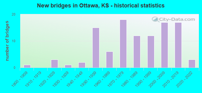
- New bridges - historical statistics
- 11900-1909
- 31920-1929
- 11930-1939
- 21940-1949
- 151950-1959
- 61960-1969
- 181970-1979
- 121980-1989
- 121990-1999
- 172000-2009
- 172010-2019
- 32020-2022

- Reconstructed bridges - Historical Statistics
- 11950-1959
- 01960-1969
- 31970-1979
- 11980-1989
- 11990-1999
- 02000-2009
- 12010-2019


- Bridge Condition - Deck
- 25.0%Very good
- 56.9%Good
- 16.7%Satisfactory
- 1.4%Poor

- Bridge Condition - Superstructure
- 59.7%Very good
- 29.2%Good
- 8.3%Satisfactory
- 2.8%Fair

- Bridge Condition - Substructure
- 52.8%Very good
- 43.1%Good
- 1.4%Satisfactory
- 1.4%Fair
- 1.4%Poor

- Bridge Condition - Channel
- 22.5%Very good
- 28.2%Good
- 46.5%Satisfactory
- 2.8%Fair

- Bridge Condition - Culverts
- 13.6%Very good
- 50.0%Good
- 36.4%Satisfactory
Find on map >> Show street view
Structure Number: 999905900301081, Location: 1.2M Nof I-35 (Lat: 38.653333, Lng: -95.235556), Route carried "on" structure: US 59, Year Built: 2010, Status: Open, Structure Length: 7.40m (24.28ft), Average Daily Traffic: 2,476 (year 2020), Truck Traffic: 10%, Average Future Daily Traffic: 3,679 (year 2041), Design Load: HL 93, Features Intersected: BNSF RAILROAD
Minimum Vertical Clearance: 30.47m (99.97ft), Kilometerpoint: 32.211, Lanes on structure: 2, Base Highway Network: Yes, Owner: State Highway Agency, Approaching Roadway Width: 12.2m (40.0ft), Material/Design: Prestressed concrete continuous, Design/Construction: Stringer/Multi-beam, Number Of Spans In Main Unit: 3, Length of Maximum Span: 27.4m (89.9ft), Curb-To-Curb Width: 12.2m (40.0ft), Out-to-Out Width: 13.0m (42.7ft)
Condition: Deck: Very good, Superstructure: Very good, Substructure: Very good, Operating Rating: 59.3 metric tons, Method Used To Determine Operating Rating: Load and Resistance Factor Rating (LRFR) rating reported by rating factor(RF) method using HL-93 loadings, Inventory Rating: 36.0 metric tons, Method Used To Determine Inventory Rating: Load and Resistance Factor Rating (LRFR) rating reported by rating factor(RF) method using HL-93 loadings, Structural Evaluation: Equal to present desirable criteria, Deck Geometry: Better than present minimum criteria, Underclear: Superior to present desirable criteria, Approach Roadway Alignment: Equal to present desirable criteria, Length Of Structure Improvement: 24.29m (79.69ft), Designated Inspection Frequency: Every 24 months, Inspection Date: March 2020, Wearing Surface/Protective System: Wearing Surface: Low Slump Concrete, Deck Protection: Epoxy Coated Reinforcing
Find on map >> Show street view
Structure Number: 999905900301091, Location: 2.3M N of I-35 (Lat: 38.664167, Lng: -95.248889), Route carried "on" structure: County highway 263, Year Built: 2010, Status: Open, Structure Length: 13.90m (45.60ft), Average Daily Traffic: 415 (year 2020), Truck Traffic: 5%, Average Future Daily Traffic: 3,596 (year 2041), Design Load: HL 93, Features Intersected: US-59 HIGHWAY, Facility Carried by Structure: MONTANA ROAD
Minimum Vertical Clearance: 30.47m (99.97ft), Kilometerpoint: 1.374, Lanes on structure: 2, Lanes under structure: 4, Owner: State Highway Agency, Approaching Roadway Width: 12.2m (40.0ft), Skew: 4 degrees, Material/Design: Prestressed concrete continuous, Design/Construction: Stringer/Multi-beam, Number Of Spans In Main Unit: 4, Length of Maximum Span: 39.6m (129.9ft), Curb-To-Curb Width: 12.2m (40.0ft), Out-to-Out Width: 13.0m (42.7ft)
Condition: Deck: Very good, Superstructure: Very good, Substructure: Very good, Operating Rating: 86.5 metric tons, Method Used To Determine Operating Rating: Load and Resistance Factor Rating (LRFR) rating reported by rating factor(RF) method using HL-93 loadings, Inventory Rating: 35.6 metric tons, Method Used To Determine Inventory Rating: Load and Resistance Factor Rating (LRFR) rating reported by rating factor(RF) method using HL-93 loadings, Structural Evaluation: Equal to present desirable criteria, Deck Geometry: Equal to present desirable criteria, Underclear: High priority of corrective action, Approach Roadway Alignment: Somewhat better than minimum adequacy, Length Of Structure Improvement: 45.61m (149.64ft), Designated Inspection Frequency: Every 24 months, Inspection Date: March 2020, Wearing Surface/Protective System: Wearing Surface: Low Slump Concrete, Deck Protection: Epoxy Coated Reinforcing
Find on map >> Show street view
Structure Number: 999905900301101, Location: 2.8M N of I-35 (Lat: 38.668889, Lng: -95.254444), Route carried "on" structure: US 59, Year Built: 2010, Status: Open, Structure Length: 1.67m (5.48ft), Average Daily Traffic: 2,354 (year 2020), Truck Traffic: 10%, Average Future Daily Traffic: 3,498 (year 2041), Design Load: HS 25 or greater, Features Intersected: WILSON CREEK
Minimum Vertical Clearance: 30.47m (99.97ft), Kilometerpoint: 36.188, Lanes on structure: 4, Base Highway Network: Yes, Owner: State Highway Agency, Approaching Roadway Width: 24.4m (80.1ft), Skew: 24 degrees, Material/Design: Concrete, Design/Construction: Culvert, Number Of Spans In Main Unit: 4, Length of Maximum Span: 2.7m (8.9ft), Curb-To-Curb Width: 12.2m (40.0ft), Out-to-Out Width: 80.2m (263.1ft)
Condition: Channel: Good, Culverts: Very good, Operating Rating: 89.8 metric tons, Method Used To Determine Operating Rating: Load Factor (LF), Inventory Rating: 55.8 metric tons, Method Used To Determine Inventory Rating: Load Factor (LF), Structural Evaluation: Equal to present desirable criteria, Deck Geometry: High priority of replacement, Waterway Adequacy: Equal to present desirable criteria, Approach Roadway Alignment: Equal to present desirable criteria, Length Of Structure Improvement: 5.48m (17.98ft), Designated Inspection Frequency: Every 24 months, Inspection Date: March 2020, Wearing Surface/Protective System: Deck Protection: Epoxy Coated Reinforcing
Find on map >> Show street view
Structure Number: 999905900301121, Location: 3.1M N I-35 (Lat: 38.671944, Lng: -95.258333), Route carried "on" structure: US 59, Year Built: 2010, Status: Open, Structure Length: 8.06m (26.44ft), Average Daily Traffic: 2,354 (year 2020), Truck Traffic: 10%, Average Future Daily Traffic: 3,498 (year 2041), Design Load: HL 93, Features Intersected: MIDLAND RAILROAD
Minimum Vertical Clearance: 30.47m (99.97ft), Kilometerpoint: 35.095, Lanes on structure: 2, Base Highway Network: Yes, Owner: State Highway Agency, Approaching Roadway Width: 12.2m (40.0ft), Skew: 3 degrees, Material/Design: Steel continuous, Design/Construction: Stringer/Multi-beam, Number Of Spans In Main Unit: 3, Length of Maximum Span: 30.4m (99.7ft), Curb-To-Curb Width: 12.2m (40.0ft), Out-to-Out Width: 13.0m (42.7ft)
Condition: Deck: Very good, Superstructure: Very good, Substructure: Very good, Operating Rating: 58.0 metric tons, Method Used To Determine Operating Rating: Load and Resistance Factor Rating (LRFR) rating reported by rating factor(RF) method using HL-93 loadings, Inventory Rating: 44.7 metric tons, Method Used To Determine Inventory Rating: Load and Resistance Factor Rating (LRFR) rating reported by rating factor(RF) method using HL-93 loadings, Structural Evaluation: Equal to present desirable criteria, Deck Geometry: Better than present minimum criteria, Underclear: Superior to present desirable criteria, Approach Roadway Alignment: Equal to present desirable criteria, Length Of Structure Improvement: 26.46m (86.81ft), Designated Inspection Frequency: Every 24 months, Inspection Date: March 2020, Wearing Surface/Protective System: Wearing Surface: Low Slump Concrete, Deck Protection: Epoxy Coated Reinforcing
Find on map >> Show street view
Structure Number: 999905900301131, Location: 3.1M N of I-35 (Lat: 38.672222, Lng: -95.258333), Route carried "on" structure: US 59, Year Built: 2010, Status: Open, Structure Length: 8.12m (26.64ft), Average Daily Traffic: 2,354 (year 2020), Truck Traffic: 10%, Average Future Daily Traffic: 3,498 (year 2041), Design Load: HL 93, Features Intersected: MIDLAND RAILROAD
Minimum Vertical Clearance: 30.47m (99.97ft), Kilometerpoint: 36.645, Lanes on structure: 2, Base Highway Network: Yes, Owner: State Highway Agency, Approaching Roadway Width: 12.2m (40.0ft), Skew: 3 degrees, Material/Design: Steel continuous, Design/Construction: Stringer/Multi-beam, Number Of Spans In Main Unit: 3, Length of Maximum Span: 30.6m (100.4ft), Curb-To-Curb Width: 12.2m (40.0ft), Out-to-Out Width: 13.0m (42.7ft)
Condition: Deck: Good, Superstructure: Very good, Substructure: Very good, Operating Rating: 58.0 metric tons, Method Used To Determine Operating Rating: Load and Resistance Factor Rating (LRFR) rating reported by rating factor(RF) method using HL-93 loadings, Inventory Rating: 44.7 metric tons, Method Used To Determine Inventory Rating: Load and Resistance Factor Rating (LRFR) rating reported by rating factor(RF) method using HL-93 loadings, Structural Evaluation: Equal to present desirable criteria, Deck Geometry: Better than present minimum criteria, Underclear: Superior to present desirable criteria, Approach Roadway Alignment: Equal to present desirable criteria, Length Of Structure Improvement: 26.65m (87.43ft), Designated Inspection Frequency: Every 24 months, Inspection Date: March 2020, Wearing Surface/Protective System: Wearing Surface: Low Slump Concrete, Deck Protection: Epoxy Coated Reinforcing
Find on map >> Show street view
Structure Number: 999905900301141, Location: 4.1M N of I-35 (Lat: 38.686667, Lng: -95.265278), Route carried "on" structure: County highway 2429, Year Built: 2008, Status: Open, Structure Length: 13.45m (44.13ft), Average Daily Traffic: 945 (year 2020), Average Future Daily Traffic: 3,596 (year 2041), Design Load: HL 93, Features Intersected: US-59 HWY, Facility Carried by Structure: NB US-59 RAMP
Minimum Vertical Clearance: 30.47m (99.97ft), Kilometerpoint: 5.498, Lanes on structure: 1, Lanes under structure: 4, Base Highway Network: Yes, Owner: State Highway Agency, Approaching Roadway Width: 8.7m (28.5ft), Skew: 4 degrees, Material/Design: Steel continuous, Design/Construction: Stringer/Multi-beam, Number Of Spans In Main Unit: 4, Length of Maximum Span: 37.5m (123.0ft), Curb-To-Curb Width: 7.9m (25.9ft), Out-to-Out Width: 8.7m (28.5ft)
Condition: Deck: Good, Superstructure: Very good, Substructure: Very good, Operating Rating: 77.1 metric tons, Method Used To Determine Operating Rating: Load and Resistance Factor Rating (LRFR) rating reported by rating factor(RF) method using HL-93 loadings, Inventory Rating: 59.3 metric tons, Method Used To Determine Inventory Rating: Load and Resistance Factor Rating (LRFR) rating reported by rating factor(RF) method using HL-93 loadings, Structural Evaluation: Equal to present desirable criteria, Deck Geometry: Somewhat better than minimum adequacy, Underclear: Better than present minimum criteria, Approach Roadway Alignment: High priority of replacement, Length Of Structure Improvement: 44.13m (144.78ft), Designated Inspection Frequency: Every 24 months, Inspection Date: March 2020, Wearing Surface/Protective System: Wearing Surface: Low Slump Concrete, Deck Protection: Epoxy Coated Reinforcing
Find on map >> Show street view
Structure Number: 999906800300711, Location: 10.91 MI E OSAGE COLN (Lat: 38.608333, Lng: -95.307500), Route carried "on" structure: State highway 68, Year Built: 1950, Status: Open, Structure Length: 8.63m (28.31ft), Average Daily Traffic: 4,018 (year 2020), Truck Traffic: 6%, Average Future Daily Traffic: 5,741 (year 2041), Design Load: H 20, Features Intersected: ISLAND CREEK
Minimum Vertical Clearance: 30.47m (99.97ft), Kilometerpoint: 17.535, Lanes on structure: 2, Base Highway Network: Yes, Owner: State Highway Agency, Approaching Roadway Width: 8.5m (27.9ft), Material/Design: Steel continuous, Design/Construction: Stringer/Multi-beam, Number Of Spans In Main Unit: 6, Length of Maximum Span: 15.2m (49.9ft), Curb-To-Curb Width: 7.9m (25.9ft), Out-to-Out Width: 9.1m (29.9ft)
Condition: Deck: Good, Superstructure: Good, Substructure: Good, Channel: Good, Operating Rating: 39.9 metric tons, Method Used To Determine Operating Rating: Load Factor (LF), Inventory Rating: 23.6 metric tons, Method Used To Determine Inventory Rating: Load Factor (LF), Structural Evaluation: Equal to present minimum criteria, Deck Geometry: High priority of corrective action, Waterway Adequacy: Meets minimum limits, Approach Roadway Alignment: Meets minimum limits, Length Of Structure Improvement: 28.31m (92.88ft), Designated Inspection Frequency: Every 24 months, Inspection Date: March 2020, Deck Structure Type: Concrete Cast-file-Place, Wearing Surface/Protective System: Wearing Surface: Low Slump Concrete
Find on map >> Show street view
Structure Number: 999906800300721, Location: 11.86 MI E OSAGE COLN (Lat: 38.608333, Lng: -95.290000), Route carried "on" structure: State highway 68, Year Built: 1950, Status: Open, Structure Length: 7.07m (23.20ft), Average Daily Traffic: 4,018 (year 2020), Truck Traffic: 6%, Average Future Daily Traffic: 5,741 (year 2041), Design Load: H 15, Features Intersected: NUGENT CREEK
Minimum Vertical Clearance: 30.47m (99.97ft), Kilometerpoint: 19.076, Lanes on structure: 2, Base Highway Network: Yes, Owner: State Highway Agency, Approaching Roadway Width: 8.5m (27.9ft), Material/Design: Concrete continuous, Design/Construction: Slab, Number Of Spans In Main Unit: 7, Length of Maximum Span: 10.7m (35.1ft), Curb-To-Curb Width: 7.9m (25.9ft), Out-to-Out Width: 9.1m (29.9ft)
Condition: Deck: Good, Superstructure: Good, Substructure: Satisfactory, Channel: Good, Operating Rating: 34.6 metric tons, Method Used To Determine Operating Rating: Load Factor (LF), Inventory Rating: 20.7 metric tons, Method Used To Determine Inventory Rating: Load Factor (LF), Structural Evaluation: Somewhat better than minimum adequacy, Deck Geometry: High priority of corrective action, Waterway Adequacy: Meets minimum limits, Approach Roadway Alignment: Meets minimum limits, Length Of Structure Improvement: 23.20m (76.12ft), Designated Inspection Frequency: Every 24 months, Inspection Date: March 2020, Deck Structure Type: Concrete Cast-file-Place, Wearing Surface/Protective System: Wearing Surface: Low Slump Concrete
Find on map >> Show street view
Structure Number: 999906800300731, Location: 13.15 MI E OSAGE COLN (Lat: 38.619167, Lng: -95.272778), Route carried "on" structure: State highway 68, Year Built: 1970, Status: Open, Structure Length: 53.56m (175.72ft), Average Daily Traffic: 5,652 (year 2020), Truck Traffic: 5%, Average Future Daily Traffic: 8,075 (year 2041), Design Load: HS 20, Features Intersected: ABDN RR, LOC RD, RIV
Minimum Vertical Clearance: 30.47m (99.97ft), Kilometerpoint: 21.148, Lanes on structure: 2, Lanes under structure: 4, Owner: State Highway Agency, Approaching Roadway Width: 13.4m (44.0ft), Skew: 2 degrees, Material/Design: Steel continuous, Design/Construction: Stringer/Multi-beam, Number Of Spans In Main Unit: 18, Length of Maximum Span: 48.8m (160.1ft), Curb-To-Curb Width: 9.1m (29.9ft), Out-to-Out Width: 9.6m (31.5ft)
Condition: Deck: Satisfactory, Superstructure: Good, Substructure: Good, Channel: Good, Operating Rating: 44.5 metric tons, Method Used To Determine Operating Rating: Load Factor (LF), Inventory Rating: 26.7 metric tons, Method Used To Determine Inventory Rating: Load Factor (LF), Structural Evaluation: Equal to present minimum criteria, Deck Geometry: Meets minimum limits, Underclear: High priority of corrective action, Waterway Adequacy: Better than present minimum criteria, Approach Roadway Alignment: Meets minimum limits, Length Of Structure Improvement: 175.71m (576.48ft), Designated Inspection Frequency: Every 24 months, Inspection Date: March 2020, Deck Structure Type: Concrete Cast-file-Place, Wearing Surface/Protective System: Wearing Surface: Low Slump Concrete
Find on map >> Show street view
Structure Number: 999906800300861, Location: 1.92 MI E I35 (Lat: 38.622500, Lng: -95.196944), Route carried "on" structure: State highway 68, Year Built: 1986, Status: Open, Structure Length: 10.72m (35.17ft), Average Daily Traffic: 5,565 (year 2020), Truck Traffic: 21%, Average Future Daily Traffic: 8,269 (year 2041), Design Load: HS 20, Features Intersected: OTTAWA CREEK
Minimum Vertical Clearance: 30.47m (99.97ft), Kilometerpoint: 28.024, Lanes on structure: 2, Base Highway Network: Yes, Owner: State Highway Agency, Approaching Roadway Width: 13.4m (44.0ft), Material/Design: Prestressed concrete continuous, Design/Construction: Stringer/Multi-beam, Number Of Spans In Main Unit: 5, Length of Maximum Span: 21.3m (69.9ft), Curb-To-Curb Width: 13.4m (44.0ft), Out-to-Out Width: 14.0m (45.9ft)
Condition: Deck: Very good, Superstructure: Very good, Substructure: Good, Channel: Very good, Operating Rating: 28.1 metric tons, Method Used To Determine Operating Rating: Load Factor (LF), Inventory Rating: 17.2 metric tons, Method Used To Determine Inventory Rating: Load Factor (LF), Structural Evaluation: Meets minimum limits, Deck Geometry: Equal to present minimum criteria, Waterway Adequacy: Somewhat better than minimum adequacy, Approach Roadway Alignment: Equal to present desirable criteria, Length Of Structure Improvement: 35.16m (115.35ft), Designated Inspection Frequency: Every 24 months, Inspection Date: March 2020, Wearing Surface/Protective System: Wearing Surface: Monolithic Concrete, Deck Protection: Epoxy Coated Reinforcing
Find on map >> Show street view
Structure Number: 999906800301211, Location: 8.65 MI E OSAGE COLN (Lat: 38.608333, Lng: -95.349444), Route carried "on" structure: State highway 68, Year Built: 2017, Status: Open, Structure Length: 13.52m (44.36ft), Average Daily Traffic: 4,320 (year 2020), Truck Traffic: 5%, Average Future Daily Traffic: 6,172 (year 2041), Design Load: HL 93, Features Intersected: MARAIS DES CYGNES RIVER
Minimum Vertical Clearance: 30.47m (99.97ft), Kilometerpoint: 13.906, Lanes on structure: 2, Base Highway Network: Yes, Owner: State Highway Agency, Approaching Roadway Width: 8.5m (27.9ft), Material/Design: Steel continuous, Design/Construction: Stringer/Multi-beam, Number Of Spans In Main Unit: 4, Length of Maximum Span: 39.6m (129.9ft), Curb-To-Curb Width: 13.4m (44.0ft), Out-to-Out Width: 14.0m (45.9ft)
Condition: Deck: Very good, Superstructure: Very good, Substructure: Very good, Channel: Good, Operating Rating: 54.4 metric tons, Method Used To Determine Operating Rating: Load and Resistance Factor Rating (LRFR) rating reported by rating factor(RF) method using HL-93 loadings, Inventory Rating: 42.1 metric tons, Method Used To Determine Inventory Rating: Load and Resistance Factor Rating (LRFR) rating reported by rating factor(RF) method using HL-93 loadings, Structural Evaluation: Equal to present desirable criteria, Deck Geometry: Better than present minimum criteria, Waterway Adequacy: Better than present minimum criteria, Approach Roadway Alignment: Better than present minimum criteria, Length Of Structure Improvement: 44.35m (145.51ft), Designated Inspection Frequency: Every 24 months, Inspection Date: March 2020, Wearing Surface/Protective System: Wearing Surface: Monolithic Concrete, Deck Protection: Epoxy Coated Reinforcing
Find on map >> Show street view
Structure Number: 999903500300161, Location: 11.87 MI E OSAGE COLN (Lat: 38.559444, Lng: -95.323056), Route carried "under" structure: Interstate 35, Year Built: 1973, Structure Length: 0. m, Average Daily Traffic: 7,004 (year 2020), Truck Traffic: 35%, Features Intersected: I35 HWY, Facility Carried by Structure: LOCAL ROAD
Minimum Vertical Clearance: 4.98m (16.34ft), Kilometerpoint: 19.085, Lanes on structure: 2, Lanes under structure: 4, Material/Design: Steel continuous, Design/Construction: Stringer/Multi-beam, Length of Maximum Span: 27.4m (89.9ft)
Find on map >> Show street view
Structure Number: 999903500300171, Location: 14.02 MI E OSAGE COLN (Lat: 38.570278, Lng: -95.286389), Route carried "under" structure: Interstate 35, Year Built: 1973, Structure Length: 0. m, Average Daily Traffic: 7,004 (year 2020), Truck Traffic: 35%, Features Intersected: I35 HWY, Facility Carried by Structure: RS1928
Minimum Vertical Clearance: 5.03m (16.50ft), Kilometerpoint: 22.545, Lanes on structure: 2, Lanes under structure: 4, Material/Design: Steel continuous, Design/Construction: Stringer/Multi-beam, Length of Maximum Span: 28.3m (92.8ft)
Find on map >> Show street view
Structure Number: 999903500300301, Location: 3.52 MI NE US59 (Lat: 38.608333, Lng: -95.232500), Route carried "under" structure: Interstate 35, Year Built: 1958, Structure Length: 0. m, Average Daily Traffic: 11,106 (year 2020), Truck Traffic: 21%, Features Intersected: I35 HWY, Facility Carried by Structure: LOCAL ROAD
Minimum Vertical Clearance: 4.98m (16.34ft), Kilometerpoint: 29.617, Lanes on structure: 2, Lanes under structure: 4, Material/Design: Concrete continuous, Design/Construction: Box Beam or Girders - Multiple, Length of Maximum Span: 20.7m (67.9ft)
Find on map >> Show street view
Structure Number: 999903500300361, Location: 7.58 MI NE US59 (Lat: 38.651944, Lng: -95.195278), Route carried "under" structure: Interstate 35, Year Built: 1958, Structure Length: 0. m, Average Daily Traffic: 11,606 (year 2020), Truck Traffic: 20%, Features Intersected: I35 HWY, Facility Carried by Structure: LOCAL ROAD
Minimum Vertical Clearance: 4.99m (16.37ft), Kilometerpoint: 36.093, Lanes on structure: 2, Lanes under structure: 4, Material/Design: Concrete continuous, Design/Construction: Box Beam or Girders - Multiple, Length of Maximum Span: 31.1m (102.0ft)
Find on map >> Show street view
Structure Number: 999903500300931, Location: .20 MI NE US 59, NB (Lat: 38.575278, Lng: -95.267500), Route carried "under" structure: US 59, Year Built: 2002, Structure Length: 0. m, Average Daily Traffic: 11,860 (year 2020), Truck Traffic: 4%, Features Intersected: US-59 HIGHWAY, Facility Carried by Structure: I-35 HWY, NB
Minimum Vertical Clearance: 5.53m (18.14ft), Kilometerpoint: 0.143, Lanes on structure: 2, Lanes under structure: 4, Material/Design: Steel continuous, Design/Construction: Stringer/Multi-beam, Length of Maximum Span: 38.5m (126.3ft)
Find on map >> Show street view
Structure Number: 999903500300941, Location: .21 MI NE US59, SB (Lat: 38.575556, Lng: -95.267500), Route carried "under" structure: US 59, Year Built: 2003, Structure Length: 0. m, Average Daily Traffic: 11,860 (year 2020), Truck Traffic: 4%, Features Intersected: OLD US-59 HIGHWAY, Facility Carried by Structure: I-35 HWY, SB
Minimum Vertical Clearance: 5.32m (17.45ft), Kilometerpoint: 0.171, Lanes on structure: 2, Lanes under structure: 4, Material/Design: Steel continuous, Design/Construction: Stringer/Multi-beam, Length of Maximum Span: 38.5m (126.3ft)
Find on map >> Show street view
Structure Number: 999903500300971, Location: 4.52 MI NE US-59, NB (Lat: 38.622778, Lng: -95.231944), Route carried "under" structure: State highway 68, Year Built: 2002, Structure Length: 0. m, Average Daily Traffic: 5,565 (year 2020), Truck Traffic: 21%, Features Intersected: K-68 HWY, Facility Carried by Structure: I-35 HWY,NB
Minimum Vertical Clearance: 5.75m (18.86ft), Kilometerpoint: 24.961, Lanes on structure: 2, Lanes under structure: 4, Material/Design: Prestressed concrete continuous, Design/Construction: Stringer/Multi-beam, Length of Maximum Span: 31.0m (101.7ft)
Find on map >> Show street view
Structure Number: 999903500300981, Location: 4.53 MI NE US-59, SB (Lat: 38.622778, Lng: -95.232222), Route carried "under" structure: State highway 68, Year Built: 2003, Structure Length: 0. m, Average Daily Traffic: 8,552 (year 2020), Truck Traffic: 8%, Features Intersected: K-68 HWY, Facility Carried by Structure: I-35 HWY, SB
Minimum Vertical Clearance: 5.34m (17.52ft), Kilometerpoint: 24.935, Lanes on structure: 2, Lanes under structure: 4, Material/Design: Prestressed concrete continuous, Design/Construction: Stringer/Multi-beam, Length of Maximum Span: 31.0m (101.7ft)
Find on map >> Show street view
Structure Number: 999903500301001, Location: I-35 NE OTT N - FR/DG COL (Lat: 38.638056, Lng: -95.222222), Route carried "under" structure: Interstate 35, Year Built: 2010, Structure Length: 0. m, Average Daily Traffic: 11,906 (year 2020), Truck Traffic: 20%, Features Intersected: I-35 HIGHWAY, Facility Carried by Structure: NB US-59 HIGHWAY
Minimum Vertical Clearance: 5.46m (17.91ft), Kilometerpoint: 33.249, Lanes on structure: 1, Lanes under structure: 4, Material/Design: Prestressed concrete continuous, Design/Construction: Stringer/Multi-beam, Length of Maximum Span: 30.5m (100.1ft)
Find on map >> Show street view
Structure Number: 999903500301011, Location: I-35 NE OTT N - FR/DG COL (Lat: 38.637778, Lng: -95.222500), Route carried "under" structure: Interstate 35, Year Built: 2010, Structure Length: 0. m, Average Daily Traffic: 11,906 (year 2020), Truck Traffic: 20%, Features Intersected: I-35 HIGHWAY, Facility Carried by Structure: SB US-59 HIGHWAY
Minimum Vertical Clearance: 5.34m (17.52ft), Kilometerpoint: 33.228, Lanes on structure: 1, Lanes under structure: 4, Material/Design: Prestressed concrete continuous, Design/Construction: Stringer/Multi-beam, Length of Maximum Span: 30.5m (100.1ft)
Find on map >> Show street view
Structure Number: 999903500301221, Location: 1.29 MI NE US59 (Lat: 38.581667, Lng: -95.249167), Route carried "under" structure: Interstate 35, Year Built: 2021, Structure Length: 0. m, Average Daily Traffic: 9,655 (year 2020), Truck Traffic: 24%, Features Intersected: I-35, Facility Carried by Structure: LOCAL ROAD
Minimum Vertical Clearance: 7.23m (23.72ft), Kilometerpoint: 26.012, Lanes on structure: 4, Lanes under structure: 4, Material/Design: Steel continuous, Design/Construction: Stringer/Multi-beam, Length of Maximum Span: 30.8m (101.0ft)
Find on map >> Show street view
Structure Number: 999905900301091, Location: 2.3M N of I-35 (Lat: 38.664167, Lng: -95.248889), Route carried "under" structure: US 59, Year Built: 2010, Structure Length: 0. m, Average Daily Traffic: 2,354 (year 2020), Truck Traffic: 10%, Features Intersected: US-59 HIGHWAY, Facility Carried by Structure: MONTANA ROAD
Minimum Vertical Clearance: 5.16m (16.93ft), Kilometerpoint: 35.435, Lanes on structure: 2, Lanes under structure: 4, Material/Design: Prestressed concrete continuous, Design/Construction: Stringer/Multi-beam, Length of Maximum Span: 39.6m (129.9ft)
Find on map >> Show street view
Structure Number: 999905900301141, Location: 4.1M N of I-35 (Lat: 38.686667, Lng: -95.265278), Route carried "under" structure: US 59, Year Built: 2008, Structure Length: 0. m, Average Daily Traffic: 2,354 (year 2020), Truck Traffic: 10%, Features Intersected: US-59 HWY
Minimum Vertical Clearance: 5.94m (19.49ft), Kilometerpoint: 38.367, Lanes on structure: 1, Lanes under structure: 4, Material/Design: Steel continuous, Design/Construction: Stringer/Multi-beam, Length of Maximum Span: 37.5m (123.0ft)