Bridge Statistics for Oxon Hill, Maryland (MD)
Condition, Traffic, Stress, Structural Evaluation, Project Costs
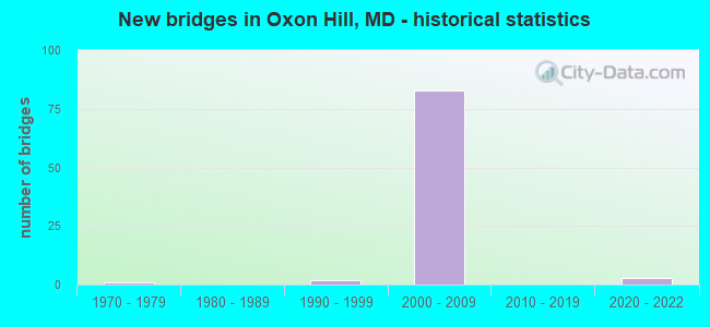
- New bridges - historical statistics
- 11970-1979
- 21990-1999
- 832000-2009
- 32020-2022


- Bridge Condition - Deck
- 18.8%Very good
- 68.8%Good
- 12.5%Satisfactory

- Bridge Condition - Superstructure
- 9.4%Excellent
- 21.9%Very good
- 62.5%Good
- 6.3%Satisfactory

- Bridge Condition - Substructure
- 9.4%Excellent
- 87.5%Good
- 3.1%Satisfactory

- Bridge Condition - Channel
- 25.0%Excellent
- 50.0%Very good
- 25.0%Good
Find on map >> Show street view
Structure Number: 10000016026701, Location: 1.0 M W OF MD210 OXENHILL (Lat: 38.795681, Lng: -77.015533), Route carried "under" structure: Ramp Interstate 95, Year Built: 2003, Structure Length: 0. m, Truck Traffic: 8%, Features Intersected: RAMP 'R'
Minimum Vertical Clearance: 5.49m (18.01ft), Kilometerpoint: 0.179, Lanes on structure: 2, Lanes under structure: 1, Material/Design: Steel continuous, Design/Construction: Stringer/Multi-beam, Length of Maximum Span: 61.3m (201.1ft)
Find on map >> Show street view
Structure Number: 10000016026701, Location: 1.0 M W OF MD210 OXENHILL (Lat: 38.795681, Lng: -77.015533), Route carried "under" structure: Ramp Interstate 95, Year Built: 2003, Structure Length: 0. m, Truck Traffic: 8%, Features Intersected: RAMP 'H'
Minimum Vertical Clearance: 6.71m (22.01ft), Kilometerpoint: 0.589, Lanes on structure: 2, Lanes under structure: 1, Material/Design: Steel continuous, Design/Construction: Stringer/Multi-beam, Length of Maximum Span: 61.3m (201.1ft)
Find on map >> Show street view
Structure Number: 10000016026701, Location: 1.042 MILE WEST OF MD 210 (Lat: 38.795681, Lng: -77.015533), Route carried "under" structure: Interstate 95, Year Built: 2003, Structure Length: 0. m, Average Daily Traffic: 141,180 (year 2009), Truck Traffic: 10%, Features Intersected: IS 95/IS 495
Minimum Vertical Clearance: 6.10m (20.01ft), Kilometerpoint: 2.780, Lanes on structure: 2, Lanes under structure: 6, Material/Design: Steel continuous, Design/Construction: Stringer/Multi-beam, Length of Maximum Span: 61.3m (201.1ft)
Find on map >> Show street view
Structure Number: 10000016026701, Location: 1.042 MILE WEST OF MD 210 (Lat: 38.795681, Lng: -77.015533), Route carried "under" structure: Ramp Interstate 95, Year Built: 2003, Structure Length: 0. m, Average Daily Traffic: 42,484 (year 2000), Truck Traffic: 10%, Features Intersected: IS 95/IS 495 IL LOCAL
Minimum Vertical Clearance: 5.18m (16.99ft), Kilometerpoint: 2.780, Lanes on structure: 2, Lanes under structure: 3, Material/Design: Steel continuous, Design/Construction: Stringer/Multi-beam, Length of Maximum Span: 61.3m (201.1ft)
Find on map >> Show street view
Structure Number: 10000016026801, Location: I-295 S Ramp to I-95/495 (Lat: 38.795158, Lng: -77.012819), Route carried "under" structure: Ramp Interstate 95, Year Built: 2003, Structure Length: 0. m, Features Intersected: RAMP 'Q'
Minimum Vertical Clearance: 10.06m (33.01ft), Kilometerpoint: 1.049, Lanes on structure: 1, Lanes under structure: 1, Material/Design: Steel continuous, Design/Construction: Stringer/Multi-beam, Length of Maximum Span: 46.0m (150.9ft)
Find on map >> Show street view
Structure Number: 10000016027001, Location: 2.0 MILE WEST OF MD 210 (Lat: 38.796119, Lng: -77.012553), Route carried "under" structure: Ramp Interstate 95, Year Built: 2005, Structure Length: 0. m, Features Intersected: RAMP Q(1)
Minimum Vertical Clearance: 7.93m (26.02ft), Kilometerpoint: 1.134, Lanes on structure: 2, Lanes under structure: 1, Material/Design: Prestressed concrete, Design/Construction: Stringer/Multi-beam, Length of Maximum Span: 36.0m (118.1ft)
Find on map >> Show street view
Structure Number: 10000016027101, Location: 2.0 MILE WEST OF MD 210 (Lat: 38.794381, Lng: -77.014017), Route carried "under" structure: Ramp Interstate 95, Year Built: 2004, Structure Length: 0. m, Features Intersected: RAMP 'Q'
Minimum Vertical Clearance: 7.32m (24.02ft), Kilometerpoint: 0.957, Lanes on structure: 1, Lanes under structure: 2, Material/Design: Steel continuous, Design/Construction: Stringer/Multi-beam, Length of Maximum Span: 62.5m (205.1ft)
Find on map >> Show street view
Structure Number: 10000016027101, Location: 2.0 MILE WEST OF MD 210 (Lat: 38.794381, Lng: -77.014017), Route carried "under" structure: Ramp Interstate 95, Year Built: 2004, Structure Length: 0. m, Features Intersected: RAMP 'T'
Minimum Vertical Clearance: 9.75m (31.99ft), Kilometerpoint: 0.471, Lanes on structure: 1, Lanes under structure: 2, Material/Design: Steel continuous, Design/Construction: Stringer/Multi-beam, Length of Maximum Span: 62.5m (205.1ft)
Find on map >> Show street view
Structure Number: 10000016027101, Location: 2.0 MILE WEST OF MD 210 (Lat: 38.794381, Lng: -77.014017), Route carried "under" structure: Ramp Interstate 95, Year Built: 2004, Structure Length: 0. m, Features Intersected: RAMP 'B'
Minimum Vertical Clearance: 9.75m (31.99ft), Kilometerpoint: 0.903, Lanes on structure: 1, Lanes under structure: 2, Material/Design: Steel continuous, Design/Construction: Stringer/Multi-beam, Length of Maximum Span: 62.5m (205.1ft)
Find on map >> Show street view
Structure Number: 10000016027101, Location: 2.0 MILE WEST OF MD 210 (Lat: 38.794381, Lng: -77.014017), Route carried "under" structure: Ramp Interstate 95, Year Built: 2004, Structure Length: 0. m, Features Intersected: RAMP 'H'
Minimum Vertical Clearance: 9.14m (29.99ft), Kilometerpoint: 0.433, Lanes on structure: 1, Lanes under structure: 2, Material/Design: Steel continuous, Design/Construction: Stringer/Multi-beam, Length of Maximum Span: 62.5m (205.1ft)
Find on map >> Show street view
Structure Number: 10000016027201, Location: 2.0 MILE WEST OF MD 210 (Lat: 38.793875, Lng: -77.018703), Route carried "under" structure: Ramp Interstate 95, Year Built: 2005, Structure Length: 0. m, Features Intersected: IS 95/IS 495 RAMP 'Q'
Minimum Vertical Clearance: 13.11m (43.01ft), Kilometerpoint: 0.994, Lanes on structure: 1, Lanes under structure: 2, Material/Design: Steel continuous, Design/Construction: Stringer/Multi-beam, Length of Maximum Span: 73.2m (240.2ft)
Find on map >> Show street view
Structure Number: 10000016027201, Location: 2.0 MILE WEST OF MD 210 (Lat: 38.793875, Lng: -77.018703), Route carried "under" structure: Ramp Interstate 95, Year Built: 2005, Structure Length: 0. m, Features Intersected: IS 95/IS 495 RAMP 'T'
Minimum Vertical Clearance: 17.37m (56.99ft), Kilometerpoint: 0.499, Lanes on structure: 1, Lanes under structure: 2, Material/Design: Steel continuous, Design/Construction: Stringer/Multi-beam, Length of Maximum Span: 73.2m (240.2ft)
Find on map >> Show street view
Structure Number: 10000016027201, Location: 2.0 MILE WEST OF MD 210 (Lat: 38.793875, Lng: -77.018703), Route carried "under" structure: Ramp Interstate 95, Year Built: 2005, Structure Length: 0. m, Features Intersected: IS 9S/IS 495 RAMP 'B'
Minimum Vertical Clearance: 17.98m (58.99ft), Kilometerpoint: 0.935, Lanes on structure: 1, Lanes under structure: 2, Material/Design: Steel continuous, Design/Construction: Stringer/Multi-beam, Length of Maximum Span: 73.2m (240.2ft)
Find on map >> Show street view
Structure Number: 10000016027201, Location: 2.0 MILE WEST OF MD 210 (Lat: 38.793875, Lng: -77.018703), Route carried "under" structure: Ramp Interstate 95, Year Built: 2005, Structure Length: 0. m, Features Intersected: IS 95/IS 495 RAMP 'G'
Minimum Vertical Clearance: 5.49m (18.01ft), Kilometerpoint: 0.399, Lanes on structure: 1, Lanes under structure: 3, Material/Design: Steel continuous, Design/Construction: Stringer/Multi-beam, Length of Maximum Span: 73.2m (240.2ft)
Find on map >> Show street view
Structure Number: 10000016027201, Location: 2.0 MILE WEST OF MD 210 (Lat: 38.793875, Lng: -77.018703), Route carried "under" structure: Ramp Interstate 95, Year Built: 2005, Structure Length: 0. m, Average Daily Traffic: 141,892 (year 2012), Features Intersected: IS 95/IS 495 OL LOCAL
Minimum Vertical Clearance: 12.80m (41.99ft), Kilometerpoint: 2.647, Lanes on structure: 1, Lanes under structure: 2, Material/Design: Steel continuous, Design/Construction: Stringer/Multi-beam, Length of Maximum Span: 73.2m (240.2ft)
Find on map >> Show street view
Structure Number: 10000016027201, Location: 2.0 MILE WEST OF MD 210 (Lat: 38.793875, Lng: -77.018703), Route carried "under" structure: Ramp Interstate 95, Year Built: 2005, Structure Length: 0. m, Features Intersected: IS 95/IS 495 RAMP 'H'
Minimum Vertical Clearance: 10.36m (33.99ft), Kilometerpoint: 0.431, Lanes on structure: 1, Lanes under structure: 2, Material/Design: Steel continuous, Design/Construction: Stringer/Multi-beam, Length of Maximum Span: 73.2m (240.2ft)
Find on map >> Show street view
Structure Number: 10000016027301, Location: 2.0 MILE WEST OF MD 210 (Lat: 38.793039, Lng: -77.015847), Route carried "under" structure: Ramp Interstate 95, Year Built: 2005, Structure Length: 0. m, Features Intersected: IS 95/IS 495 RAMP 'B'
Minimum Vertical Clearance: 5.18m (16.99ft), Kilometerpoint: 0.619, Lanes on structure: 1, Lanes under structure: 2, Material/Design: Prestressed concrete, Design/Construction: Stringer/Multi-beam, Length of Maximum Span: 35.7m (117.1ft)
Find on map >> Show street view
Structure Number: 10000016027401, Location: 2.0 MILE WEST OF MD 210 (Lat: 38.793142, Lng: -77.015258), Route carried "under" structure: Ramp Interstate 95, Year Built: 2005, Structure Length: 0. m, Features Intersected: IS 95/IS 495 RAMP 'B'
Minimum Vertical Clearance: 5.49m (18.01ft), Kilometerpoint: 0.682, Lanes on structure: 1, Lanes under structure: 2, Material/Design: Prestressed concrete, Design/Construction: Stringer/Multi-beam, Length of Maximum Span: 36.3m (119.1ft)
Find on map >> Show street view
Structure Number: 10000016027501, Location: 2.0 MILE WEST OF MD 210 (Lat: 38.792000, Lng: -77.014564), Route carried "under" structure: Ramp Interstate 95, Year Built: 2004, Structure Length: 0. m, Features Intersected: IS 95/IS 495 RAMP X
Minimum Vertical Clearance: 6.10m (20.01ft), Kilometerpoint: 0.331, Lanes on structure: 2, Lanes under structure: 1, Material/Design: Steel continuous, Design/Construction: Stringer/Multi-beam, Length of Maximum Span: 36.6m (120.1ft)
Find on map >> Show street view
Structure Number: 10000016027501, Location: 2.0 MILE WEST OF MD 210 (Lat: 38.792000, Lng: -77.014564), Route carried "under" structure: Ramp Interstate 95, Year Built: 2004, Structure Length: 0. m, Features Intersected: IS 95/IS 495 RAMP 'K'
Minimum Vertical Clearance: 5.49m (18.01ft), Kilometerpoint: 0.343, Lanes on structure: 2, Lanes under structure: 1, Material/Design: Steel continuous, Design/Construction: Stringer/Multi-beam, Length of Maximum Span: 36.6m (120.1ft)
Find on map >> Show street view
Structure Number: 10000016027501, Location: 2.0 MILE WEST OF MD 210 (Lat: 38.792000, Lng: -77.014564), Route carried "under" structure: Ramp Interstate 95, Year Built: 2004, Structure Length: 0. m, Features Intersected: IS 95/IS 495 RAMP 'P'
Minimum Vertical Clearance: 6.10m (20.01ft), Kilometerpoint: 0.378, Lanes on structure: 2, Lanes under structure: 1, Material/Design: Steel continuous, Design/Construction: Stringer/Multi-beam, Length of Maximum Span: 36.6m (120.1ft)
Find on map >> Show street view
Structure Number: 10000016027601, Location: 2.0 MILE WEST OF MD 210 (Lat: 38.791714, Lng: -77.013844), Route carried "under" structure: Ramp Interstate 95, Year Built: 2004, Structure Length: 0. m, Features Intersected: IS 95/IS 495 RAMP 'P'
Minimum Vertical Clearance: 5.49m (18.01ft), Kilometerpoint: 0.399, Lanes on structure: 1, Lanes under structure: 1, Material/Design: Steel continuous, Design/Construction: Stringer/Multi-beam, Length of Maximum Span: 30.5m (100.1ft)
Find on map >> Show street view
Structure Number: 10000016027601, Location: 2.0 MILE WEST OF MD 210 (Lat: 38.791714, Lng: -77.013844), Route carried "under" structure: Ramp Interstate 95, Year Built: 2004, Structure Length: 0. m, Features Intersected: IS 95/IS 495 RAMP 'K'
Minimum Vertical Clearance: 5.49m (18.01ft), Kilometerpoint: 0.417, Lanes on structure: 1, Lanes under structure: 1, Material/Design: Steel continuous, Design/Construction: Stringer/Multi-beam, Length of Maximum Span: 30.5m (100.1ft)
Find on map >> Show street view
Structure Number: 10000016027601, Location: 2.0 MILE WEST OF MD 210 (Lat: 38.791714, Lng: -77.013844), Route carried "under" structure: Ramp Interstate 95, Year Built: 2004, Structure Length: 0. m, Features Intersected: IS 95/IS 495 RAMP 'X'
Minimum Vertical Clearance: 5.79m (19.00ft), Kilometerpoint: 0.278, Lanes on structure: 1, Lanes under structure: 1, Material/Design: Steel continuous, Design/Construction: Stringer/Multi-beam, Length of Maximum Span: 30.5m (100.1ft)
Find on map >> Show street view
Structure Number: 10000016027701, Location: 2.0 MILE WEST OF MD 210 (Lat: 38.791858, Lng: -77.013469), Route carried "under" structure: Ramp Interstate 95, Year Built: 2004, Structure Length: 0. m, Features Intersected: BELTWAY ACCESS PARCEL RD
Minimum Vertical Clearance: 5.79m (19.00ft), Kilometerpoint: 0.462, Lanes on structure: 1, Lanes under structure: 2, Material/Design: Steel continuous, Design/Construction: Stringer/Multi-beam, Length of Maximum Span: 33.5m (109.9ft)
Find on map >> Show street view
Structure Number: 10000016027801, Location: 2.0 MILE WEST OF MD 210 (Lat: 38.791911, Lng: -77.013375), Route carried "under" structure: Ramp Interstate 95, Year Built: 2004, Structure Length: 0. m, Features Intersected: IS 95/IS 495 RAMP 'V'
Minimum Vertical Clearance: 5.49m (18.01ft), Kilometerpoint: 0.082, Lanes on structure: 1, Lanes under structure: 1, Material/Design: Steel continuous, Design/Construction: Stringer/Multi-beam, Length of Maximum Span: 36.0m (118.1ft)
Find on map >> Show street view
Structure Number: 10000016027801, Location: 2.0 MILE WEST OF MD 210 (Lat: 38.791911, Lng: -77.013375), Route carried "under" structure: Ramp Interstate 95, Year Built: 2004, Structure Length: 0. m, Features Intersected: BELTWAY PARCEL
Minimum Vertical Clearance: 5.79m (19.00ft), Kilometerpoint: 0.211, Lanes on structure: 1, Lanes under structure: 2, Material/Design: Steel continuous, Design/Construction: Stringer/Multi-beam, Length of Maximum Span: 36.0m (118.1ft)
Find on map >> Show street view
Structure Number: 10000016028001, Location: 2.0 MILE WEST OF MD 210 (Lat: 38.796047, Lng: -77.013794), Route carried "under" structure: Ramp Interstate 95, Year Built: 2006, Structure Length: 0. m, Features Intersected: IS 95/IS 495 RAMP 'T'
Minimum Vertical Clearance: 6.10m (20.01ft), Kilometerpoint: 0.668, Lanes on structure: 2, Lanes under structure: 1, Material/Design: Prestressed concrete continuous, Design/Construction: Stringer/Multi-beam, Length of Maximum Span: 25.3m (83.0ft)
Find on map >> Show street view
Structure Number: 10000016028001, Location: 2.0 MILE WEST OF MD 210 (Lat: 38.796047, Lng: -77.013794), Route carried "under" structure: Ramp Interstate 95, Year Built: 2006, Structure Length: 0. m, Features Intersected: IS 95/IS 495 RAMP 'B'
Minimum Vertical Clearance: 5.49m (18.01ft), Kilometerpoint: 1.089, Lanes on structure: 2, Lanes under structure: 2, Material/Design: Prestressed concrete continuous, Design/Construction: Stringer/Multi-beam, Length of Maximum Span: 25.3m (83.0ft)
Find on map >> Show street view
Structure Number: 10000016028101, Location: 2.0 MILE WEST OF MD 210 (Lat: 38.796517, Lng: -77.012747), Route carried "under" structure: Ramp Interstate 95, Year Built: 2006, Structure Length: 0. m, Features Intersected: IS 95/IS 495 RAMP 'Q'
Minimum Vertical Clearance: 5.18m (16.99ft), Kilometerpoint: 1.216, Lanes on structure: 2, Lanes under structure: 1, Material/Design: Prestressed concrete, Design/Construction: Stringer/Multi-beam, Length of Maximum Span: 33.5m (109.9ft)
Find on map >> Show street view
Structure Number: 10000016028201, Location: 2.0 MILE WEST OF MD 210 (Lat: 38.796456, Lng: -77.012372), Route carried "under" structure: Ramp Interstate 95, Year Built: 2008, Structure Length: 0. m, Features Intersected: IS 95/IS 495 RAMP 'Q'
Minimum Vertical Clearance: 7.93m (26.02ft), Kilometerpoint: 1.134, Lanes on structure: 6, Lanes under structure: 1, Material/Design: Prestressed concrete, Design/Construction: Stringer/Multi-beam, Length of Maximum Span: 34.7m (113.8ft)
Find on map >> Show street view
Structure Number: 10000016028301, Location: 2.0 MILE WEST OF MD 210 (Lat: 38.796014, Lng: -77.014339), Route carried "under" structure: Ramp Interstate 95, Year Built: 2006, Structure Length: 0. m, Features Intersected: IS 95/IS 495 RAMP 'B'
Minimum Vertical Clearance: 5.18m (16.99ft), Kilometerpoint: 1.112, Lanes on structure: 1, Lanes under structure: 2, Material/Design: Prestressed concrete continuous, Design/Construction: Stringer/Multi-beam, Length of Maximum Span: 25.0m (82.0ft)
Find on map >> Show street view
Structure Number: 10000016028301, Location: 2.0 MILE WEST OF MD 210 (Lat: 38.796014, Lng: -77.014339), Route carried "under" structure: Ramp Interstate 95, Year Built: 2006, Structure Length: 0. m, Features Intersected: IS 95/IS 495 RAMP 'T'
Minimum Vertical Clearance: 5.49m (18.01ft), Kilometerpoint: 0.684, Lanes on structure: 1, Lanes under structure: 1, Material/Design: Prestressed concrete continuous, Design/Construction: Stringer/Multi-beam, Length of Maximum Span: 25.0m (82.0ft)
Find on map >> Show street view
Structure Number: 10000016028501, Location: 0.06 MILE NORTH OF MD 414 (Lat: 38.803172, Lng: -76.996492), Route carried "under" structure: Ramp Interstate 95, Year Built: 2005, Structure Length: 0. m, Average Daily Traffic: 12,000 (year 2000), Truck Traffic: 10%, Features Intersected: IS 95/IS 495 RAMP G, Facility Carried by Structure: MD 210 RAMP F
Minimum Vertical Clearance: 5.49m (18.01ft), Kilometerpoint: 0.134, Lanes on structure: 1, Lanes under structure: 1, Material/Design: Prestressed concrete, Design/Construction: Stringer/Multi-beam, Length of Maximum Span: 23.2m (76.1ft)
Find on map >> Show street view
Structure Number: 10000016029401, Location: 0.211 M W OF FELKER ROAD (Lat: 38.801858, Lng: -76.998792), Route carried "under" structure: State highway 414, Year Built: 2007, Structure Length: 0. m, Average Daily Traffic: 38,650 (year 2005), Truck Traffic: 10%, Features Intersected: MD 414 (OXON HILL ROAD), Facility Carried by Structure: MD 210
Minimum Vertical Clearance: 5.49m (18.01ft), Kilometerpoint: 0.837, Lanes on structure: 7, Lanes under structure: 5, Material/Design: Steel, Design/Construction: Stringer/Multi-beam, Length of Maximum Span: 42.7m (140.1ft)
Find on map >> Show street view
Structure Number: 10000016029501, Location: 0.3 M E OF IS 95/ IS 495 (Lat: 38.800861, Lng: -77.000653), Route carried "under" structure: State highway 414, Year Built: 2008, Structure Length: 0. m, Average Daily Traffic: 16,390 (year 2009), Truck Traffic: 10%, Features Intersected: MD 414 (OXON HILL ROAD), Facility Carried by Structure: MD 210 RAMP B
Minimum Vertical Clearance: 6.71m (22.01ft), Kilometerpoint: 0.608, Lanes on structure: 1, Lanes under structure: 6, Material/Design: Steel continuous, Design/Construction: Stringer/Multi-beam, Length of Maximum Span: 51.5m (169.0ft)
Find on map >> Show street view
Structure Number: 10000016029501, Location: 1.05 MILE NORTH OF IS 295 (Lat: 38.800861, Lng: -77.000653), Route carried "under" structure: Interstate 95, Year Built: 2008, Structure Length: 0. m, Average Daily Traffic: 141,180 (year 2009), Truck Traffic: 11%, Features Intersected: IS 95/IS 495 ILE & OLL, Facility Carried by Structure: MD 210 RAMP B
Minimum Vertical Clearance: 4.88m (16.01ft), Kilometerpoint: 4.013, Lanes on structure: 1, Lanes under structure: 8, Material/Design: Steel continuous, Design/Construction: Stringer/Multi-beam, Length of Maximum Span: 51.5m (169.0ft)