Bridge Statistics for Parsons, Kansas (KS)
Condition, Traffic, Stress, Structural Evaluation, Project Costs
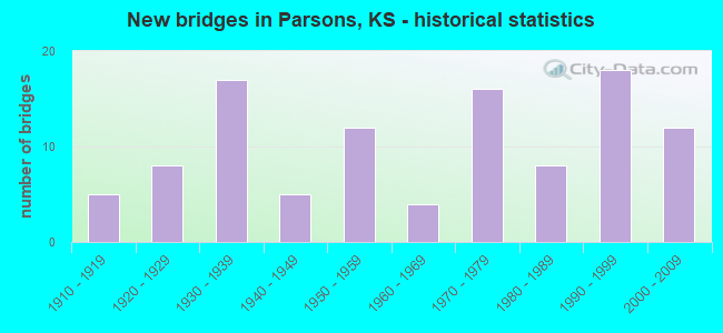
- New bridges - historical statistics
- 51910-1919
- 81920-1929
- 171930-1939
- 51940-1949
- 121950-1959
- 41960-1969
- 161970-1979
- 81980-1989
- 181990-1999
- 122000-2009

- Reconstructed bridges - Historical Statistics
- 21960-1969
- 01970-1979
- 31980-1989
- 11990-1999


- Bridge Condition - Deck
- 6.3%Very good
- 43.8%Good
- 33.8%Satisfactory
- 13.8%Fair
- 1.3%Poor
- 1.3%Serious

- Bridge Condition - Superstructure
- 23.8%Very good
- 47.5%Good
- 17.5%Satisfactory
- 10.0%Fair
- 1.3%Poor

- Bridge Condition - Substructure
- 25.0%Very good
- 31.3%Good
- 30.0%Satisfactory
- 12.5%Fair
- 1.3%Poor

- Bridge Condition - Channel
- 14.4%Very good
- 21.6%Good
- 42.3%Satisfactory
- 16.5%Fair
- 5.2%Poor

- Bridge Condition - Culverts
- 8.7%Very good
- 52.2%Good
- 30.4%Satisfactory
- 8.7%Fair
Find on map >> Show street view
Structure Number: 999905900500144, Location: 0.73 MI N 5400, MAIN ST. (Lat: 37.351111, Lng: -95.258889), Route carried "on" structure: US 59, Year Built: 1937, Year Reconstructed: 1968, Status: Open, Structure Length: 6.76m (22.18ft), Average Daily Traffic: 7,154 (year 2020), Truck Traffic: 9%, Average Future Daily Traffic: 9,082 (year 2041), Design Load: H 15, Features Intersected: LABETTE CREEK
Minimum Vertical Clearance: 30.47m (99.97ft), Kilometerpoint: 53.244, Lanes on structure: 2, Owner: State Highway Agency, Approaching Roadway Width: 13.4m (44.0ft), Material/Design: Steel continuous, Design/Construction: Stringer/Multi-beam, Number Of Spans In Main Unit: 3, Length of Maximum Span: 25.2m (82.7ft), Curb-To-Curb Width: 13.4m (44.0ft), Out-to-Out Width: 14.0m (45.9ft)
Condition: Deck: Good, Superstructure: Good, Substructure: Good, Channel: Satisfactory, Operating Rating: 44.5 metric tons, Method Used To Determine Operating Rating: Load Factor (LF), Inventory Rating: 27.2 metric tons, Method Used To Determine Inventory Rating: Load Factor (LF), Structural Evaluation: Equal to present minimum criteria, Deck Geometry: Equal to present minimum criteria, Waterway Adequacy: Equal to present minimum criteria, Approach Roadway Alignment: Meets minimum limits, Length Of Structure Improvement: 22.18m (72.77ft), Designated Inspection Frequency: Every 24 months, Inspection Date: Febuary 2020, Deck Structure Type: Concrete Cast-file-Place, Wearing Surface/Protective System: Wearing Surface: Low Slump Concrete
Find on map >> Show street view
Structure Number: 999905900500151, Location: 1.1 MI N US 400 (Lat: 37.382500, Lng: -95.260833), Route carried "on" structure: US 59, Year Built: 1937, Year Reconstructed: 1968, Status: Posted for load-capacity, Structure Length: 8.76m (28.74ft), Average Daily Traffic: 8,360 (year 2020), Truck Traffic: 7%, Average Future Daily Traffic: 9,237 (year 2041), Design Load: H 15, Features Intersected: UP RAILROAD
Minimum Vertical Clearance: 30.47m (99.97ft), Kilometerpoint: 56.800, Lanes on structure: 2, Owner: State Highway Agency, Approaching Roadway Width: 13.4m (44.0ft), Skew: 4 degrees, Material/Design: Concrete, Design/Construction: Tee Beam, Number Of Spans In Main Unit: 7, Length of Maximum Span: 18.0m (59.1ft), Curb-To-Curb Width: 13.4m (44.0ft), Out-to-Out Width: 14.0m (45.9ft)
Condition: Deck: Satisfactory, Superstructure: Fair, Substructure: Satisfactory, Operating Rating: 63.5 metric tons, Method Used To Determine Operating Rating: Load Factor (LF), Inventory Rating: 38.1 metric tons, Method Used To Determine Inventory Rating: Load Factor (LF), Structural Evaluation: Somewhat better than minimum adequacy, Deck Geometry: Equal to present minimum criteria, Underclear: Meets minimum limits, Approach Roadway Alignment: Meets minimum limits, Length Of Structure Improvement: 28.75m (94.32ft), Designated Inspection Frequency: Every 24 months, Inspection Date: Febuary 2020, Deck Structure Type: Concrete Cast-file-Place, Wearing Surface/Protective System: Wearing Surface: Low Slump Concrete
Find on map >> Show street view
Structure Number: 999905900670951, Location: 6.55 MI S K-47/U-59 SJCT (Lat: 37.418056, Lng: -95.270000), Route carried "on" structure: US 59, Year Built: 2005, Status: Open, Structure Length: 4.07m (13.35ft), Average Daily Traffic: 8,360 (year 2020), Truck Traffic: 7%, Average Future Daily Traffic: 9,237 (year 2041), Design Load: HL 93, Features Intersected: LABETTE CREEK
Minimum Vertical Clearance: 30.47m (99.97ft), Kilometerpoint: 4.019, Lanes on structure: 2, Base Highway Network: Yes, Owner: State Highway Agency, Approaching Roadway Width: 13.4m (44.0ft), Material/Design: Concrete continuous, Design/Construction: Slab, Number Of Spans In Main Unit: 3, Length of Maximum Span: 16.0m (52.5ft), Curb-To-Curb Width: 13.4m (44.0ft), Out-to-Out Width: 14.0m (45.9ft)
Condition: Deck: Good, Superstructure: Very good, Substructure: Very good, Channel: Good, Operating Rating: 45.0 metric tons, Method Used To Determine Operating Rating: Load and Resistance Factor Rating (LRFR) rating reported by rating factor(RF) method using HL-93 loadings, Inventory Rating: 34.7 metric tons, Method Used To Determine Inventory Rating: Load and Resistance Factor Rating (LRFR) rating reported by rating factor(RF) method using HL-93 loadings, Structural Evaluation: Equal to present desirable criteria, Deck Geometry: Equal to present minimum criteria, Waterway Adequacy: Equal to present desirable criteria, Approach Roadway Alignment: Equal to present desirable criteria, Length Of Structure Improvement: 13.37m (43.86ft), Designated Inspection Frequency: Every 24 months, Inspection Date: Febuary 2020, Wearing Surface/Protective System: Wearing Surface: Monolithic Concrete, Deck Protection: Epoxy Coated Reinforcing
Find on map >> Show street view
Structure Number: 999916900500701, Location: 0.04 MI E MONTGOMERY COLN (Lat: 37.358611, Lng: -95.520278), Route carried "on" structure: US 169, Year Built: 1995, Status: Open, Structure Length: 3.43m (11.25ft), Average Daily Traffic: 4,504 (year 2020), Truck Traffic: 25%, Average Future Daily Traffic: 6,693 (year 2041), Design Load: HS 25 or greater, Features Intersected: ROCK CREEK
Minimum Vertical Clearance: 30.47m (99.97ft), Kilometerpoint: 0.002, Lanes on structure: 2, Base Highway Network: Yes, Owner: State Highway Agency, Approaching Roadway Width: 13.4m (44.0ft), Material/Design: Concrete continuous, Design/Construction: Slab, Number Of Spans In Main Unit: 3, Length of Maximum Span: 13.4m (44.0ft), Curb-To-Curb Width: 13.4m (44.0ft), Out-to-Out Width: 14.0m (45.9ft)
Condition: Deck: Good, Superstructure: Good, Substructure: Very good, Channel: Very good, Operating Rating: 79.8 metric tons, Method Used To Determine Operating Rating: Load Factor (LF), Inventory Rating: 48.1 metric tons, Method Used To Determine Inventory Rating: Load Factor (LF), Structural Evaluation: Better than present minimum criteria, Deck Geometry: Better than present minimum criteria, Waterway Adequacy: Better than present minimum criteria, Approach Roadway Alignment: Somewhat better than minimum adequacy, Length Of Structure Improvement: 11.25m (36.91ft), Designated Inspection Frequency: Every 24 months, Inspection Date: Febuary 2020, Wearing Surface/Protective System: Wearing Surface: Monolithic Concrete, Deck Protection: Epoxy Coated Reinforcing
Find on map >> Show street view
Structure Number: 999916900630891, Location: 6.86 MI N OF NJCT 160/169 (Lat: 37.309167, Lng: -95.540278), Route carried "on" structure: US 169, Year Built: 1998, Status: Open, Structure Length: 1.87m (6.14ft), Average Daily Traffic: 5,302 (year 2020), Truck Traffic: 25%, Average Future Daily Traffic: 7,878 (year 2041), Design Load: HS 20, Features Intersected: CHERRY CREEK TRIBUTARY
Minimum Vertical Clearance: 30.47m (99.97ft), Kilometerpoint: 38.550, Lanes on structure: 2, Base Highway Network: Yes, Owner: State Highway Agency, Approaching Roadway Width: 13.4m (44.0ft), Skew: 4 degrees, Material/Design: Concrete, Design/Construction: Culvert, Number Of Spans In Main Unit: 3, Length of Maximum Span: 4.3m (14.1ft), Curb-To-Curb Width: 13.4m (44.0ft), Out-to-Out Width: 37.8m (124.0ft)
Condition: Channel: Good, Culverts: Good, Operating Rating: 74.4 metric tons, Method Used To Determine Operating Rating: Load Factor (LF), Inventory Rating: 44.5 metric tons, Method Used To Determine Inventory Rating: Load Factor (LF), Structural Evaluation: Better than present minimum criteria, Deck Geometry: Equal to present minimum criteria, Waterway Adequacy: Better than present minimum criteria, Approach Roadway Alignment: Equal to present desirable criteria, Length Of Structure Improvement: 6.13m (20.11ft), Designated Inspection Frequency: Every 24 months, Inspection Date: March 2021, Deck Structure Type: Concrete Cast-file-Place, Wearing Surface/Protective System: Wearing Surface: Bituminous
Find on map >> Show street view
Structure Number: 999916900670851, Location: 0.38 MI N LABETTE COLN (Lat: 37.389167, Lng: -95.507778), Route carried "on" structure: US 169, Year Built: 1998, Status: Open, Structure Length: 3.74m (12.27ft), Average Daily Traffic: 4,504 (year 2020), Truck Traffic: 25%, Average Future Daily Traffic: 6,693 (year 2041), Design Load: HS 20, Features Intersected: DRUM CREEK
Minimum Vertical Clearance: 30.47m (99.97ft), Kilometerpoint: 0.610, Lanes on structure: 2, Base Highway Network: Yes, Owner: State Highway Agency, Approaching Roadway Width: 13.4m (44.0ft), Material/Design: Concrete continuous, Design/Construction: Slab, Number Of Spans In Main Unit: 3, Length of Maximum Span: 14.6m (47.9ft), Curb-To-Curb Width: 13.4m (44.0ft), Out-to-Out Width: 14.0m (45.9ft)
Condition: Deck: Very good, Superstructure: Very good, Substructure: Very good, Channel: Good, Operating Rating: 74.4 metric tons, Method Used To Determine Operating Rating: Load Factor (LF), Inventory Rating: 44.5 metric tons, Method Used To Determine Inventory Rating: Load Factor (LF), Structural Evaluation: Equal to present desirable criteria, Deck Geometry: Better than present minimum criteria, Waterway Adequacy: Better than present minimum criteria, Approach Roadway Alignment: Equal to present desirable criteria, Length Of Structure Improvement: 12.26m (40.22ft), Designated Inspection Frequency: Every 24 months, Inspection Date: Febuary 2020, Wearing Surface/Protective System: Wearing Surface: Monolithic Concrete, Deck Protection: Epoxy Coated Reinforcing
Find on map >> Show street view
Structure Number: 999940000500711, Location: 3.81 MI E MONTGOMERY COLN (Lat: 37.343333, Lng: -95.450833), Route carried "on" structure: US 400, Year Built: 1997, Status: Open, Structure Length: 5.42m (17.78ft), Average Daily Traffic: 4,563 (year 2020), Truck Traffic: 26%, Average Future Daily Traffic: 7,477 (year 2041), Design Load: HS 25 or greater, Features Intersected: BIG HILL CREEK
Minimum Vertical Clearance: 30.47m (99.97ft), Kilometerpoint: 6.135, Lanes on structure: 2, Base Highway Network: Yes, Owner: State Highway Agency, Approaching Roadway Width: 13.4m (44.0ft), Skew: 3 degrees, Material/Design: Prestressed concrete continuous, Design/Construction: Stringer/Multi-beam, Number Of Spans In Main Unit: 3, Length of Maximum Span: 19.8m (65.0ft), Curb-To-Curb Width: 13.4m (44.0ft), Out-to-Out Width: 14.0m (45.9ft)
Condition: Deck: Very good, Superstructure: Very good, Substructure: Very good, Channel: Good, Operating Rating: 55.4 metric tons, Method Used To Determine Operating Rating: Load Factor (LF), Inventory Rating: 33.2 metric tons, Method Used To Determine Inventory Rating: Load Factor (LF), Structural Evaluation: Equal to present desirable criteria, Deck Geometry: Better than present minimum criteria, Waterway Adequacy: Equal to present desirable criteria, Approach Roadway Alignment: Equal to present desirable criteria, Length Of Structure Improvement: 17.78m (58.33ft), Designated Inspection Frequency: Every 24 months, Inspection Date: Febuary 2020, Wearing Surface/Protective System: Wearing Surface: Epoxy Overlay, Deck Protection: Epoxy Coated Reinforcing
Find on map >> Show street view
Structure Number: 999940000500771, Location: 6.8 MI. W US-59/U-400 JCT (Lat: 37.344722, Lng: -95.348333), Route carried "on" structure: US 400, Year Built: 2001, Status: Open, Structure Length: 5.63m (18.47ft), Average Daily Traffic: 5,491 (year 2020), Truck Traffic: 21%, Average Future Daily Traffic: 8,998 (year 2041), Design Load: HS 25 or greater, Features Intersected: LITTLE LABETTE CREEK
Minimum Vertical Clearance: 30.47m (99.97ft), Kilometerpoint: 15.213, Lanes on structure: 2, Base Highway Network: Yes, Owner: State Highway Agency, Approaching Roadway Width: 12.2m (40.0ft), Material/Design: Concrete continuous, Design/Construction: Slab, Number Of Spans In Main Unit: 4, Length of Maximum Span: 15.8m (51.8ft), Curb-To-Curb Width: 13.4m (44.0ft), Out-to-Out Width: 14.0m (45.9ft)
Condition: Deck: Good, Superstructure: Very good, Substructure: Very good, Channel: Good, Operating Rating: 87.1 metric tons, Method Used To Determine Operating Rating: Load Factor (LF), Inventory Rating: 51.7 metric tons, Method Used To Determine Inventory Rating: Load Factor (LF), Structural Evaluation: Equal to present desirable criteria, Deck Geometry: Equal to present minimum criteria, Waterway Adequacy: Equal to present desirable criteria, Approach Roadway Alignment: Equal to present desirable criteria, Length Of Structure Improvement: 18.46m (60.56ft), Designated Inspection Frequency: Every 24 months, Inspection Date: Febuary 2020, Wearing Surface/Protective System: Wearing Surface: Monolithic Concrete, Deck Protection: Epoxy Coated Reinforcing
Find on map >> Show street view
Structure Number: 999940000500781, Location: 4.87 MI W US-59/U-400 JCT (Lat: 37.348611, Lng: -95.326667), Route carried "on" structure: US 400, Year Built: 2001, Status: Open, Structure Length: 1.32m (4.33ft), Average Daily Traffic: 5,491 (year 2020), Truck Traffic: 21%, Average Future Daily Traffic: 8,998 (year 2041), Design Load: HS 20, Features Intersected: LITTLE LABETTE CR TRIB
Minimum Vertical Clearance: 30.47m (99.97ft), Kilometerpoint: 17.199, Lanes on structure: 2, Base Highway Network: Yes, Owner: State Highway Agency, Approaching Roadway Width: 13.4m (44.0ft), Material/Design: Concrete, Design/Construction: Culvert, Number Of Spans In Main Unit: 3, Length of Maximum Span: 4.3m (14.1ft), Curb-To-Curb Width: 25.0m (82.0ft), Out-to-Out Width: 30.2m (99.1ft)
Condition: Channel: Good, Culverts: Very good, Inventory Rating: 88.9 metric tons, Method Used To Determine Inventory Rating: Load Factor (LF), Structural Evaluation: Equal to present desirable criteria, Deck Geometry: Superior to present desirable criteria, Waterway Adequacy: Equal to present desirable criteria, Approach Roadway Alignment: Somewhat better than minimum adequacy, Length Of Structure Improvement: 8.15m (26.74ft), Designated Inspection Frequency: Every 24 months, Inspection Date: Febuary 2020, Deck Structure Type: Concrete Cast-file-Place, Wearing Surface/Protective System: Wearing Surface: Monolithic Concrete
Find on map >> Show street view
Structure Number: 999940000500791, Location: 3.8 MI W US-59/U-400 JCT (Lat: 37.355556, Lng: -95.313333), Route carried "on" structure: US 400, Year Built: 2001, Status: Open, Structure Length: 1.14m (3.74ft), Average Daily Traffic: 5,491 (year 2020), Truck Traffic: 21%, Average Future Daily Traffic: 8,998 (year 2041), Design Load: HS 20, Features Intersected: LITTLE LABETTE CR TRIB
Minimum Vertical Clearance: 30.47m (99.97ft), Kilometerpoint: 18.625, Lanes on structure: 2, Base Highway Network: Yes, Owner: State Highway Agency, Approaching Roadway Width: 24.4m (80.1ft), Material/Design: Concrete, Design/Construction: Culvert, Number Of Spans In Main Unit: 3, Length of Maximum Span: 3.7m (12.1ft), Curb-To-Curb Width: 24.4m (80.1ft), Out-to-Out Width: 29.0m (95.1ft)
Condition: Channel: Good, Culverts: Very good, Inventory Rating: 78.0 metric tons, Method Used To Determine Inventory Rating: Load Factor (LF), Structural Evaluation: Equal to present desirable criteria, Deck Geometry: Superior to present desirable criteria, Waterway Adequacy: Equal to present desirable criteria, Approach Roadway Alignment: Equal to present desirable criteria, Length Of Structure Improvement: 3.75m (12.30ft), Designated Inspection Frequency: Every 24 months, Inspection Date: Febuary 2020, Deck Structure Type: Concrete Cast-file-Place, Wearing Surface/Protective System: Wearing Surface: Monolithic Concrete
Find on map >> Show street view
Structure Number: 999940000500801, Location: .95 MI W US-59/U-400 JCT (Lat: 37.369167, Lng: -95.274444), Route carried "on" structure: US 400, Year Built: 2001, Status: Open, Structure Length: 7.82m (25.66ft), Average Daily Traffic: 5,491 (year 2020), Truck Traffic: 21%, Average Future Daily Traffic: 8,998 (year 2041), Design Load: HS 25 or greater, Features Intersected: UP RR & 26000 ROAD
Minimum Vertical Clearance: 30.47m (99.97ft), Kilometerpoint: 22.581, Lanes on structure: 2, Lanes under structure: 2, Base Highway Network: Yes, Owner: State Highway Agency, Approaching Roadway Width: 13.4m (44.0ft), Skew: 3 degrees, Material/Design: Prestressed concrete continuous, Design/Construction: Stringer/Multi-beam, Number Of Spans In Main Unit: 4, Length of Maximum Span: 25.6m (84.0ft), Curb-To-Curb Width: 13.4m (44.0ft), Out-to-Out Width: 14.0m (45.9ft)
Condition: Deck: Good, Superstructure: Very good, Substructure: Very good, Operating Rating: 73.5 metric tons, Method Used To Determine Operating Rating: Load Factor (LF), Inventory Rating: 36.3 metric tons, Method Used To Determine Inventory Rating: Load Factor (LF), Structural Evaluation: Equal to present desirable criteria, Deck Geometry: Equal to present minimum criteria, Underclear: Superior to present desirable criteria, Approach Roadway Alignment: Equal to present desirable criteria, Length Of Structure Improvement: 25.66m (84.19ft), Designated Inspection Frequency: Every 24 months, Inspection Date: Febuary 2020, Wearing Surface/Protective System: Wearing Surface: Low Slump Concrete, Deck Protection: Epoxy Coated Reinforcing
Find on map >> Show street view
Structure Number: 999940000500811, Location: .7 MI W U-400/U-59 JCT (Lat: 37.368333, Lng: -95.270278), Route carried "on" structure: US 400, Year Built: 2001, Status: Open, Structure Length: 12.00m (39.37ft), Average Daily Traffic: 5,491 (year 2020), Truck Traffic: 21%, Average Future Daily Traffic: 8,998 (year 2041), Design Load: HS 25 or greater, Features Intersected: LABETTE CREEK
Minimum Vertical Clearance: 30.47m (99.97ft), Kilometerpoint: 22.932, Lanes on structure: 2, Base Highway Network: Yes, Owner: State Highway Agency, Approaching Roadway Width: 13.4m (44.0ft), Skew: 3 degrees, Material/Design: Prestressed concrete continuous, Design/Construction: Stringer/Multi-beam, Number Of Spans In Main Unit: 4, Length of Maximum Span: 30.5m (100.1ft), Curb-To-Curb Width: 13.4m (44.0ft), Out-to-Out Width: 14.0m (45.9ft)
Condition: Deck: Good, Superstructure: Very good, Substructure: Very good, Channel: Very good, Operating Rating: 89.8 metric tons, Method Used To Determine Operating Rating: Load Factor (LF), Inventory Rating: 49.9 metric tons, Method Used To Determine Inventory Rating: Load Factor (LF), Structural Evaluation: Equal to present desirable criteria, Deck Geometry: Equal to present minimum criteria, Waterway Adequacy: Equal to present desirable criteria, Approach Roadway Alignment: Equal to present desirable criteria, Length Of Structure Improvement: 39.36m (129.13ft), Designated Inspection Frequency: Every 24 months, Inspection Date: Febuary 2020, Wearing Surface/Protective System: Wearing Surface: Low Slump Concrete, Deck Protection: Epoxy Coated Reinforcing
Find on map >> Show street view
Structure Number: 999940000500821, Location: US-59/U-400 JCT (Lat: 37.366667, Lng: -95.258333), Route carried "on" structure: US 400, Year Built: 2001, Status: Open, Structure Length: 7.33m (24.05ft), Average Daily Traffic: 3,962 (year 2020), Truck Traffic: 26%, Average Future Daily Traffic: 6,492 (year 2041), Design Load: HS 25 or greater, Features Intersected: US-59 HIGHWAY
Minimum Vertical Clearance: 30.47m (99.97ft), Kilometerpoint: 24.036, Lanes on structure: 2, Lanes under structure: 2, Base Highway Network: Yes, Owner: State Highway Agency, Approaching Roadway Width: 13.4m (44.0ft), Skew: 1 degrees, Material/Design: Steel continuous, Design/Construction: Stringer/Multi-beam, Number Of Spans In Main Unit: 3, Length of Maximum Span: 32.9m (107.9ft), Curb-To-Curb Width: 13.4m (44.0ft), Out-to-Out Width: 14.0m (45.9ft)
Condition: Deck: Good, Superstructure: Good, Substructure: Very good, Operating Rating: 99.8 metric tons, Method Used To Determine Operating Rating: Load Factor (LF), Inventory Rating: 59.9 metric tons, Method Used To Determine Inventory Rating: Load Factor (LF), Structural Evaluation: Better than present minimum criteria, Deck Geometry: Better than present minimum criteria, Underclear: Better than present minimum criteria, Approach Roadway Alignment: Meets minimum limits, Length Of Structure Improvement: 24.06m (78.94ft), Designated Inspection Frequency: Every 24 months, Inspection Date: Febuary 2020, Wearing Surface/Protective System: Wearing Surface: Low Slump Concrete, Deck Protection: Epoxy Coated Reinforcing
Find on map >> Show street view
Structure Number: 999940000500831, Location: .3 MI E U-400/U-59 JCT (Lat: 37.365833, Lng: -95.253056), Route carried "on" structure: US 400, Year Built: 2001, Status: Open, Structure Length: 7.58m (24.87ft), Average Daily Traffic: 3,962 (year 2020), Truck Traffic: 26%, Average Future Daily Traffic: 6,492 (year 2041), Design Load: HS 25 or greater, Features Intersected: TOLEN CREEK & ACCESS RD
Minimum Vertical Clearance: 30.47m (99.97ft), Kilometerpoint: 24.517, Lanes on structure: 4, Base Highway Network: Yes, Owner: State Highway Agency, Approaching Roadway Width: 15.8m (51.8ft), Skew: 3 degrees, Material/Design: Prestressed concrete continuous, Design/Construction: Stringer/Multi-beam, Number Of Spans In Main Unit: 3, Length of Maximum Span: 25.9m (85.0ft), Curb-To-Curb Width: 19.5m (64.0ft), Out-to-Out Width: 20.1m (65.9ft)
Condition: Deck: Good, Superstructure: Very good, Substructure: Good, Channel: Very good, Operating Rating: 78.2 metric tons, Method Used To Determine Operating Rating: Load Factor (LF), Inventory Rating: 38.0 metric tons, Method Used To Determine Inventory Rating: Load Factor (LF), Structural Evaluation: Better than present minimum criteria, Deck Geometry: Better than present minimum criteria, Waterway Adequacy: Equal to present desirable criteria, Approach Roadway Alignment: Meets minimum limits, Length Of Structure Improvement: 24.86m (81.56ft), Designated Inspection Frequency: Every 24 months, Inspection Date: Febuary 2020, Wearing Surface/Protective System: Wearing Surface: Low Slump Concrete, Deck Protection: Epoxy Coated Reinforcing
Find on map >> Show street view
Structure Number: 999940000500841, Location: .5 MI E U-59/U-400 JCT (Lat: 37.365000, Lng: -95.249167), Route carried "on" structure: US 400, Year Built: 2005, Status: Open, Structure Length: 1.52m (4.99ft), Average Daily Traffic: 3,962 (year 2020), Truck Traffic: 26%, Average Future Daily Traffic: 6,492 (year 2041), Design Load: HS 20, Features Intersected: TOLEN CREEK TRIBUTARY
Minimum Vertical Clearance: 30.47m (99.97ft), Kilometerpoint: 24.866, Lanes on structure: 2, Base Highway Network: Yes, Owner: State Highway Agency, Approaching Roadway Width: 13.4m (44.0ft), Skew: 3 degrees, Material/Design: Concrete, Design/Construction: Culvert, Number Of Spans In Main Unit: 3, Length of Maximum Span: 4.3m (14.1ft), Curb-To-Curb Width: 20.4m (66.9ft), Out-to-Out Width: 23.5m (77.1ft)
Condition: Channel: Good, Culverts: Good, Inventory Rating: 61.7 metric tons, Method Used To Determine Inventory Rating: Load Factor (LF), Structural Evaluation: Better than present minimum criteria, Deck Geometry: Superior to present desirable criteria, Waterway Adequacy: Better than present minimum criteria, Approach Roadway Alignment: Meets minimum limits, Length Of Structure Improvement: 6.52m (21.39ft), Designated Inspection Frequency: Every 24 months, Inspection Date: Febuary 2020, Deck Structure Type: Concrete Cast-file-Place, Wearing Surface/Protective System: Wearing Surface: Monolithic Concrete
Find on map >> Show street view
Structure Number: 999940000630831, Location: 7.75 MI E OF 75/400 JCT (Lat: 37.346944, Lng: -95.556667), Route carried "on" structure: US 400, Year Built: 1997, Status: Open, Structure Length: 6.75m (22.15ft), Average Daily Traffic: 3,600 (year 2020), Truck Traffic: 31%, Average Future Daily Traffic: 5,899 (year 2041), Design Load: HS 20, Features Intersected: DRUM CREEK
Minimum Vertical Clearance: 30.47m (99.97ft), Kilometerpoint: 15.833, Lanes on structure: 2, Base Highway Network: Yes, Owner: State Highway Agency, Approaching Roadway Width: 13.4m (44.0ft), Skew: 3 degrees, Material/Design: Prestressed concrete continuous, Design/Construction: Stringer/Multi-beam, Number Of Spans In Main Unit: 3, Length of Maximum Span: 30.5m (100.1ft), Curb-To-Curb Width: 13.4m (44.0ft), Out-to-Out Width: 14.0m (45.9ft)
Condition: Deck: Good, Superstructure: Very good, Substructure: Very good, Channel: Very good, Operating Rating: 89.8 metric tons, Method Used To Determine Operating Rating: Load Factor (LF), Inventory Rating: 66.0 metric tons, Method Used To Determine Inventory Rating: Load Factor (LF), Structural Evaluation: Equal to present desirable criteria, Deck Geometry: Better than present minimum criteria, Waterway Adequacy: Equal to present desirable criteria, Approach Roadway Alignment: Equal to present desirable criteria, Length Of Structure Improvement: 22.15m (72.67ft), Designated Inspection Frequency: Every 24 months, Inspection Date: March 2021, Wearing Surface/Protective System: Wearing Surface: Low Slump Concrete, Deck Protection: Epoxy Coated Reinforcing
Find on map >> Show street view
Structure Number: 999940000630841, Location: US169/US400 JCT (Lat: 37.346667, Lng: -95.530556), Route carried "on" structure: US 400, Year Built: 1998, Status: Open, Structure Length: 7.86m (25.79ft), Average Daily Traffic: 3,600 (year 2020), Truck Traffic: 31%, Average Future Daily Traffic: 5,899 (year 2041), Design Load: HS 20, Features Intersected: US-169 HWY
Minimum Vertical Clearance: 30.47m (99.97ft), Kilometerpoint: 18.153, Lanes on structure: 3, Lanes under structure: 3, Base Highway Network: Yes, Owner: State Highway Agency, Approaching Roadway Width: 16.5m (54.1ft), Skew: 2 degrees, Material/Design: Steel continuous, Design/Construction: Stringer/Multi-beam, Number Of Spans In Main Unit: 3, Length of Maximum Span: 37.5m (123.0ft), Curb-To-Curb Width: 16.5m (54.1ft), Out-to-Out Width: 17.1m (56.1ft)
Condition: Deck: Good, Superstructure: Good, Substructure: Very good, Operating Rating: 81.6 metric tons, Method Used To Determine Operating Rating: Load Factor (LF), Inventory Rating: 49.0 metric tons, Method Used To Determine Inventory Rating: Load Factor (LF), Structural Evaluation: Better than present minimum criteria, Deck Geometry: Better than present minimum criteria, Underclear: Better than present minimum criteria, Approach Roadway Alignment: Meets minimum limits, Length Of Structure Improvement: 25.77m (84.55ft), Designated Inspection Frequency: Every 24 months, Inspection Date: Febuary 2021, Wearing Surface/Protective System: Wearing Surface: Low Slump Concrete, Deck Protection: Epoxy Coated Reinforcing
Find on map >> Show street view
Structure Number: 999940000630851, Location: 0.35 MI E US160/US169 JCT (Lat: 37.346667, Lng: -95.524167), Route carried "on" structure: US 400, Year Built: 1998, Status: Open, Structure Length: 5.85m (19.19ft), Average Daily Traffic: 4,475 (year 2020), Truck Traffic: 26%, Average Future Daily Traffic: 7,333 (year 2041), Design Load: HS 20, Features Intersected: SKO RR
Minimum Vertical Clearance: 30.47m (99.97ft), Kilometerpoint: 18.720, Lanes on structure: 3, Base Highway Network: Yes, Owner: State Highway Agency, Approaching Roadway Width: 16.5m (54.1ft), Skew: 1 degrees, Material/Design: Prestressed concrete continuous, Design/Construction: Stringer/Multi-beam, Number Of Spans In Main Unit: 3, Length of Maximum Span: 20.4m (66.9ft), Curb-To-Curb Width: 16.5m (54.1ft), Out-to-Out Width: 17.1m (56.1ft)
Condition: Deck: Good, Superstructure: Very good, Substructure: Very good, Operating Rating: 85.4 metric tons, Method Used To Determine Operating Rating: Load Factor (LF), Inventory Rating: 51.2 metric tons, Method Used To Determine Inventory Rating: Load Factor (LF), Structural Evaluation: Equal to present desirable criteria, Deck Geometry: Better than present minimum criteria, Underclear: Superior to present desirable criteria, Approach Roadway Alignment: Meets minimum limits, Length Of Structure Improvement: 19.18m (62.93ft), Designated Inspection Frequency: Every 24 months, Inspection Date: March 2021, Wearing Surface/Protective System: Wearing Surface: Low Slump Concrete, Deck Protection: Epoxy Coated Reinforcing
Find on map >> Show street view
Structure Number: 999940000500821, Location: US-59/U-400 JCT (Lat: 37.366667, Lng: -95.258333), Route carried "under" structure: US 59, Year Built: 2001, Structure Length: 0. m, Average Daily Traffic: 8,360 (year 2020), Truck Traffic: 7%, Features Intersected: US-59 HIGHWAY, Facility Carried by Structure: US-400 HIGHWAY
Minimum Vertical Clearance: 4.91m (16.11ft), Kilometerpoint: 54.974, Lanes on structure: 2, Lanes under structure: 2, Material/Design: Steel continuous, Design/Construction: Stringer/Multi-beam, Length of Maximum Span: 32.9m (107.9ft)
Find on map >> Show street view
Structure Number: 999940000630841, Location: US169/US400 JCT (Lat: 37.346667, Lng: -95.530556), Route carried "under" structure: US 169, Year Built: 1998, Structure Length: 0. m, Average Daily Traffic: 5,847 (year 2020), Truck Traffic: 23%, Features Intersected: US-169 HWY, Facility Carried by Structure: US-400 HWY
Minimum Vertical Clearance: 5.67m (18.60ft), Kilometerpoint: 42.839, Lanes on structure: 3, Lanes under structure: 3, Material/Design: Steel continuous, Design/Construction: Stringer/Multi-beam, Length of Maximum Span: 37.5m (123.0ft)