Bridge Statistics for Paterson, New Jersey (NJ)
Condition, Traffic, Stress, Structural Evaluation, Project Costs
- National Bridge Inventory (NBI) Statistics
- 105Number of bridges
- 1,253ft / 382mTotal length
- $34,714,000Total costs
- 2,714,776Total average daily traffic
- 171,944Total average daily truck traffic
- National Bridge Inventory (NBI) Registered Bridges for Paterson
- No street view available for this location
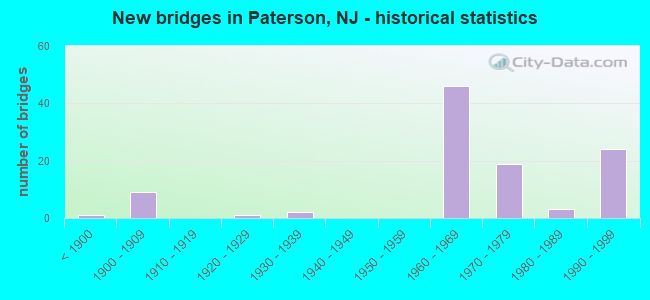
- New bridges - historical statistics
- 1Before 1900
- 91900-1909
- 11920-1929
- 21930-1939
- 461960-1969
- 191970-1979
- 31980-1989
- 241990-1999

- Reconstructed bridges - Historical Statistics
- 11960-1969
- 01970-1979
- 71980-1989
- 31990-1999
- 12000-2009
- 12010-2019


- Bridge Condition - Deck
- 2.0%Very good
- 30.6%Good
- 34.7%Satisfactory
- 30.6%Fair
- 2.0%Poor

- Bridge Condition - Superstructure
- 3.8%Very good
- 48.1%Good
- 19.2%Satisfactory
- 26.9%Fair
- 1.9%Serious

- Bridge Condition - Substructure
- 38.5%Good
- 44.2%Satisfactory
- 15.4%Fair
- 1.9%Poor

- Bridge Condition - Channel
- 21.7%Very good
- 43.5%Good
- 21.7%Satisfactory
- 8.7%Fair
- 4.3%Poor
Find on map >> Show street view
Structure Number: 161017, Location: 0.13 MI WEST OF NJ 20 (Lat: 40.901569, Lng: -74.137450), Route carried "on" structure: Interstate 80, Year Built: 1963, Year Reconstructed: 1993, Status: Open, Structure Length: 1.86m (6.10ft), Average Daily Traffic: 138,000 (year 2020), Truck Traffic: 9%, Average Future Daily Traffic: 165,600 (year 2040), Design Load: HS 20+Mod, Features Intersected: I-80 RAMP E
Minimum Vertical Clearance: 30+ m (98+ ft), Kilometerpoint: 96.979, Lanes on structure: 7, Lanes under structure: 1, Base Highway Network: Yes, Owner: State Highway Agency, Approaching Roadway Width: 36.0m (118.1ft), Skew: 31 degrees, Material/Design: Prestressed concrete, Design/Construction: Stringer/Multi-beam, Number Of Spans In Main Unit: 1, Length of Maximum Span: 17.4m (57.1ft), Curb or Sidewalk Widths: Left: 0.5m (1.6ft), Right: 0.0m, Curb-To-Curb Width: 36.0m (118.1ft), Out-to-Out Width: 38.9m (127.6ft)
Condition: Deck: Satisfactory, Superstructure: Satisfactory, Substructure: Good, Operating Rating: 56.2 metric tons, Method Used To Determine Operating Rating: Load Factor (LF), Inventory Rating: 33.6 metric tons, Method Used To Determine Inventory Rating: Load Factor (LF), Structural Evaluation: Equal to present minimum criteria, Deck Geometry: Superior to present desirable criteria, Underclear: High priority of corrective action, Approach Roadway Alignment: Equal to present desirable criteria, Length Of Structure Improvement: 1.86m (6.10ft), Designated Inspection Frequency: Every 24 months, Inspection Date: August 2020, Roadway Improvement Cost: $675,000, Total Project Cost: $810,000 ( Estimate for 2020), Deck Structure Type: Concrete Cast-file-Place, Wearing Surface/Protective System: Wearing Surface: Latex Concrete
Find on map >> Show street view
Structure Number: 1610171, Location: 0.1 MILE EAST OF EXIT 57 (Lat: 40.907719, Lng: -74.171200), Route carried "on" structure: Interstate 80, Year Built: 1971, Status: Open, Structure Length: 6.04m (19.82ft), Average Daily Traffic: 131,900 (year 2020), Truck Traffic: 9%, Average Future Daily Traffic: 158,300 (year 2040), Design Load: HS 20+Mod, Features Intersected: MAIN & MARSHALL STREETS
Minimum Vertical Clearance: 30+ m (98+ ft), Kilometerpoint: 93.873, Lanes on structure: 9, Lanes under structure: 4, Base Highway Network: Yes, Owner: State Highway Agency, Approaching Roadway Width: 39.3m (128.9ft), Skew: 33 degrees, Material/Design: Steel, Design/Construction: Stringer/Multi-beam, Number Of Spans In Main Unit: 2, Length of Maximum Span: 29.6m (97.1ft), Curb or Sidewalk Widths: Left: 0.8m (2.6ft), Right: 0.2m (0.7ft), Curb-To-Curb Width: 39.3m (128.9ft), Out-to-Out Width: 41.9m (137.5ft)
Condition: Deck: Fair, Superstructure: Fair, Substructure: Satisfactory, Operating Rating: 74.4 metric tons, Method Used To Determine Operating Rating: Load Factor (LF), Inventory Rating: 44.5 metric tons, Method Used To Determine Inventory Rating: Load Factor (LF), Structural Evaluation: Somewhat better than minimum adequacy, Deck Geometry: Equal to present minimum criteria, Underclear: Equal to present minimum criteria, Approach Roadway Alignment: Equal to present desirable criteria, Designated Inspection Frequency: Every 24 months, Inspection Date: July 2020, Deck Structure Type: Concrete Cast-file-Place, Wearing Surface/Protective System: Wearing Surface: Latex Concrete
Find on map >> Show street view
Structure Number: 1610172, Location: 0.1 MI SOUTH OF RTE I-80 (Lat: 40.906969, Lng: -74.170850), Route carried "on" structure: Ramp Interstate 80, Year Built: 1971, Status: Open, Structure Length: 6.00m (19.69ft), Average Daily Traffic: 21,200 (year 2020), Truck Traffic: 9%, Average Future Daily Traffic: 25,400 (year 2040), Design Load: HS 20+Mod, Features Intersected: MAIN & MARSHALL STREETS
Minimum Vertical Clearance: 30+ m (98+ ft), Kilometerpoint: 93.873, Lanes on structure: 2, Lanes under structure: 4, Owner: State Highway Agency, Approaching Roadway Width: 9.1m (29.9ft), Skew: 39 degrees, Material/Design: Steel, Design/Construction: Stringer/Multi-beam, Number Of Spans In Main Unit: 2, Length of Maximum Span: 30.8m (101.0ft), Curb or Sidewalk Widths: Left: 0.8m (2.6ft), Right: 0.8m (2.6ft), Curb-To-Curb Width: 9.3m (30.5ft), Out-to-Out Width: 11.2m (36.7ft)
Condition: Deck: Good, Superstructure: Fair, Substructure: Satisfactory, Operating Rating: 68.0 metric tons, Method Used To Determine Operating Rating: Load Factor (LF), Inventory Rating: 40.8 metric tons, Method Used To Determine Inventory Rating: Load Factor (LF), Structural Evaluation: Somewhat better than minimum adequacy, Deck Geometry: Somewhat better than minimum adequacy, Underclear: Equal to present minimum criteria, Approach Roadway Alignment: Better than present minimum criteria, Designated Inspection Frequency: Every 24 months, Inspection Date: July 2020, Deck Structure Type: Concrete Cast-file-Place, Wearing Surface/Protective System: Wearing Surface: Bituminous
Find on map >> Show street view
Structure Number: 1610173, Location: AT I-80 EXIT 57 (Lat: 40.908281, Lng: -74.171000), Route carried "on" structure: Ramp Interstate 80, Year Built: 1971, Status: Open, Structure Length: 3.17m (10.40ft), Average Daily Traffic: 4,660 (year 2020), Truck Traffic: 9%, Average Future Daily Traffic: 6,580 (year 2040), Design Load: HS 20, Features Intersected: MAIN STREET(CO.RTE.601)
Minimum Vertical Clearance: 30+ m (98+ ft), Kilometerpoint: 93.937, Lanes on structure: 1, Lanes under structure: 2, Owner: State Highway Agency, Approaching Roadway Width: 6.7m (22.0ft), Skew: 3 degrees, Material/Design: Steel, Design/Construction: Stringer/Multi-beam, Number Of Spans In Main Unit: 1, Length of Maximum Span: 29.3m (96.1ft), Curb or Sidewalk Widths: Left: 0.5m (1.6ft), Right: 0.8m (2.6ft), Curb-To-Curb Width: 6.7m (22.0ft), Out-to-Out Width: 8.7m (28.5ft)
Condition: Deck: Satisfactory, Superstructure: Good, Substructure: Good, Operating Rating: 84.4 metric tons, Method Used To Determine Operating Rating: Load Factor (LF), Inventory Rating: 50.8 metric tons, Method Used To Determine Inventory Rating: Load Factor (LF), Structural Evaluation: Better than present minimum criteria, Deck Geometry: Equal to present minimum criteria, Underclear: Equal to present minimum criteria, Approach Roadway Alignment: Somewhat better than minimum adequacy, Designated Inspection Frequency: Every 24 months, Inspection Date: October 2020, Deck Structure Type: Concrete Cast-file-Place, Wearing Surface/Protective System: Wearing Surface: Monolithic Concrete, Deck Protection: Epoxy Coated Reinforcing
Find on map >> Show street view
Structure Number: 1610174, Location: I 80 EXIT 57 (Lat: 40.909731, Lng: -74.174250), Route carried "on" structure: Ramp Interstate 80, Year Built: 1992, Status: Open, Structure Length: 24.08m (79.00ft), Average Daily Traffic: 1,377 (year 2020), Truck Traffic: 9%, Average Future Daily Traffic: 1,652 (year 2040), Design Load: HS 20, Features Intersected: I 80 RAMP FM & GRAND ST
Minimum Vertical Clearance: 30+ m (98+ ft), Kilometerpoint: 93.696, Lanes on structure: 1, Lanes under structure: 5, Owner: State Highway Agency, Approaching Roadway Width: 7.3m (24.0ft), Skew: 9 degrees, Material/Design: Steel continuous, Design/Construction: Stringer/Multi-beam, Number Of Spans In Main Unit: 5, Number Of Approach Spans: 5, Length of Maximum Span: 29.6m (97.1ft), Curb-To-Curb Width: 7.5m (24.6ft), Out-to-Out Width: 8.4m (27.6ft)
Condition: Deck: Good, Superstructure: Good, Substructure: Satisfactory, Operating Rating: 60.8 metric tons, Method Used To Determine Operating Rating: Load Factor (LF), Inventory Rating: 36.3 metric tons, Method Used To Determine Inventory Rating: Load Factor (LF), Structural Evaluation: Equal to present minimum criteria, Deck Geometry: Better than present minimum criteria, Underclear: Somewhat better than minimum adequacy, Approach Roadway Alignment: Equal to present minimum criteria, Designated Inspection Frequency: Every 24 months, Critical Feature Inspection Frequency: Every 24 months, Inspection Date: July 2020, Critical Feature Inspection Date: July 2020, Deck Structure Type: Concrete Cast-file-Place, Wearing Surface/Protective System: Wearing Surface: Monolithic Concrete, Deck Protection: Epoxy Coated Reinforcing
Find on map >> Show street view
Structure Number: 1610175, Location: 0.4 MI WEST OF CR 601 (Lat: 40.909861, Lng: -74.174461), Route carried "on" structure: Ramp Interstate 80, Year Built: 1992, Status: Open, Structure Length: 33.99m (111.52ft), Average Daily Traffic: 1,408 (year 2020), Truck Traffic: 9%, Average Future Daily Traffic: 1,690 (year 2040), Design Load: HS 20+Mod, Features Intersected: RT.19& RAMPS C,D,DE &FM
Minimum Vertical Clearance: 30+ m (98+ ft), Kilometerpoint: 93.696, Lanes on structure: 1, Lanes under structure: 8, Owner: State Highway Agency, Approaching Roadway Width: 7.3m (24.0ft), Skew: 9 degrees, Material/Design: Steel continuous, Design/Construction: Stringer/Multi-beam, Number Of Spans In Main Unit: 11, Number Of Approach Spans: 3, Length of Maximum Span: 36.0m (118.1ft), Curb-To-Curb Width: 7.3m (24.0ft), Out-to-Out Width: 8.4m (27.6ft)
Condition: Deck: Good, Superstructure: Good, Substructure: Satisfactory, Operating Rating: 49.9 metric tons, Method Used To Determine Operating Rating: Load Factor (LF), Inventory Rating: 29.9 metric tons, Method Used To Determine Inventory Rating: Load Factor (LF), Structural Evaluation: Equal to present minimum criteria, Deck Geometry: Better than present minimum criteria, Underclear: Somewhat better than minimum adequacy, Approach Roadway Alignment: Equal to present minimum criteria, Designated Inspection Frequency: Every 24 months, Critical Feature Inspection Frequency: Every 24 months, Inspection Date: July 2020, Critical Feature Inspection Date: July 2020, Deck Structure Type: Concrete Cast-file-Place, Wearing Surface/Protective System: Wearing Surface: Monolithic Concrete, Deck Protection: Epoxy Coated Reinforcing
Find on map >> Show street view
Structure Number: 1610176, Location: NJ 19 NB exit to I-80 WB (Lat: 40.910689, Lng: -74.175339), Route carried "on" structure: Ramp Interstate 80, Year Built: 1993, Status: Open, Structure Length: 22.22m (72.90ft), Average Daily Traffic: 7,362 (year 2020), Truck Traffic: 5%, Average Future Daily Traffic: 8,834 (year 2040), Design Load: HS 20+Mod, Features Intersected: NJ ROUTE 19 & RAMP DE
Minimum Vertical Clearance: 30+ m (98+ ft), Kilometerpoint: 93.696, Lanes on structure: 1, Lanes under structure: 6, Owner: State Highway Agency, Approaching Roadway Width: 7.6m (24.9ft), Skew: 9 degrees, Material/Design: Steel continuous, Design/Construction: Stringer/Multi-beam, Number Of Spans In Main Unit: 6, Number Of Approach Spans: 4, Length of Maximum Span: 25.6m (84.0ft), Curb-To-Curb Width: 7.3m (24.0ft), Out-to-Out Width: 8.4m (27.6ft)
Condition: Deck: Good, Superstructure: Good, Substructure: Satisfactory, Operating Rating: 72.6 metric tons, Method Used To Determine Operating Rating: Load Factor (LF), Inventory Rating: 43.5 metric tons, Method Used To Determine Inventory Rating: Load Factor (LF), Structural Evaluation: Equal to present minimum criteria, Deck Geometry: Better than present minimum criteria, Underclear: Equal to present desirable criteria, Approach Roadway Alignment: Equal to present minimum criteria, Designated Inspection Frequency: Every 24 months, Critical Feature Inspection Frequency: Every 24 months, Inspection Date: July 2020, Critical Feature Inspection Date: July 2020, Deck Structure Type: Concrete Cast-file-Place, Wearing Surface/Protective System: Wearing Surface: Monolithic Concrete, Deck Protection: Epoxy Coated Reinforcing
Find on map >> Show street view
Structure Number: 1613151, Location: 0.4 MI N OF US 46 JCT (Lat: 40.880750, Lng: -74.166869), Route carried "on" structure: Ramp State highway 19, Year Built: 1968, Status: Open, Structure Length: 5.52m (18.11ft), Average Daily Traffic: 16,233 (year 2021), Truck Traffic: 5%, Average Future Daily Traffic: 19,480 (year 2041), Design Load: HS 20+Mod, Features Intersected: ROUTE NJ19 NORTHBOUND
Minimum Vertical Clearance: 30+ m (98+ ft), Kilometerpoint: 0.708, Lanes on structure: 1, Lanes under structure: 2, Owner: State Highway Agency, Approaching Roadway Width: 11.3m (37.1ft), Skew: 5 degrees, Material/Design: Steel, Design/Construction: Stringer/Multi-beam, Number Of Spans In Main Unit: 3, Length of Maximum Span: 27.1m (88.9ft), Curb or Sidewalk Widths: Left: 0.5m (1.6ft), Right: 0.5m (1.6ft), Curb-To-Curb Width: 11.3m (37.1ft), Out-to-Out Width: 13.0m (42.7ft)
Condition: Deck: Satisfactory, Superstructure: Fair, Substructure: Fair, Operating Rating: 79.8 metric tons, Method Used To Determine Operating Rating: Load Factor (LF), Inventory Rating: 48.1 metric tons, Method Used To Determine Inventory Rating: Load Factor (LF), Structural Evaluation: Somewhat better than minimum adequacy, Deck Geometry: Superior to present desirable criteria, Underclear: High priority of corrective action, Approach Roadway Alignment: Equal to present desirable criteria, Length Of Structure Improvement: 5.52m (18.11ft), Designated Inspection Frequency: Every 24 months, Inspection Date: March 2021, Roadway Improvement Cost: $338,000, Total Project Cost: $449,000 ( Estimate for 2021), Deck Structure Type: Concrete Cast-file-Place, Wearing Surface/Protective System: Wearing Surface: Monolithic Concrete
Find on map >> Show street view
Structure Number: 1613155, Location: 1.7 MI NO OF RT 46 (Lat: 40.899069, Lng: -74.170711), Route carried "on" structure: County highway 621, Year Built: 1968, Status: Open, Structure Length: 5.82m (19.09ft), Average Daily Traffic: 10,049 (year 2021), Truck Traffic: 4%, Average Future Daily Traffic: 12,059 (year 2041), Design Load: HS 20+Mod, Features Intersected: ROUTE NJ 19
Minimum Vertical Clearance: 30+ m (98+ ft), Kilometerpoint: 5.086, Lanes on structure: 2, Lanes under structure: 6, Base Highway Network: Yes, Owner: State Highway Agency, Approaching Roadway Width: 9.1m (29.9ft), Skew: 4 degrees, Material/Design: Steel, Design/Construction: Stringer/Multi-beam, Number Of Spans In Main Unit: 2, Length of Maximum Span: 28.0m (91.9ft), Curb or Sidewalk Widths: Left: 2.4m (7.9ft), Right: 2.4m (7.9ft), Curb-To-Curb Width: 9.2m (30.2ft), Out-to-Out Width: 14.8m (48.6ft)
Condition: Deck: Fair, Superstructure: Satisfactory, Substructure: Satisfactory, Operating Rating: 64.4 metric tons, Method Used To Determine Operating Rating: Load Factor (LF), Inventory Rating: 38.1 metric tons, Method Used To Determine Inventory Rating: Load Factor (LF), Structural Evaluation: Equal to present minimum criteria, Deck Geometry: High priority of corrective action, Underclear: High priority of corrective action, Approach Roadway Alignment: Better than present minimum criteria, Length Of Structure Improvement: 5.82m (19.09ft), Designated Inspection Frequency: Every 24 months, Inspection Date: March 2021, Bridge Improvement Cost: $472,000, Roadway Improvement Cost: $102,000, Total Project Cost: $754,000 ( Estimate for 2021), Deck Structure Type: Concrete Cast-file-Place, Wearing Surface/Protective System: Wearing Surface: Monolithic Concrete
Find on map >> Show street view
Structure Number: 1613156, Location: .16 Mi South of I-80 (Lat: 40.906419, Lng: -74.172119), Route carried "on" structure: State highway 19, Year Built: 1973, Status: Open, Structure Length: 3.87m (12.70ft), Average Daily Traffic: 22,944 (year 2021), Truck Traffic: 5%, Average Future Daily Traffic: 27,533 (year 2041), Design Load: HS 20, Features Intersected: RAMP M
Minimum Vertical Clearance: 30+ m (98+ ft), Kilometerpoint: 3.701, Lanes on structure: 3, Lanes under structure: 1, Base Highway Network: Yes, Owner: State Highway Agency, Approaching Roadway Width: 16.6m (54.5ft), Skew: 2 degrees, Material/Design: Steel, Design/Construction: Stringer/Multi-beam, Number Of Spans In Main Unit: 1, Length of Maximum Span: 36.6m (120.1ft), Curb-To-Curb Width: 16.6m (54.5ft), Out-to-Out Width: 17.8m (58.4ft)
Condition: Deck: Satisfactory, Superstructure: Good, Substructure: Good, Operating Rating: 43.5 metric tons, Method Used To Determine Operating Rating: Load Factor (LF), Inventory Rating: 26.3 metric tons, Method Used To Determine Inventory Rating: Load Factor (LF), Structural Evaluation: Equal to present minimum criteria, Deck Geometry: Equal to present minimum criteria, Underclear: High priority of corrective action, Approach Roadway Alignment: Better than present minimum criteria, Length Of Structure Improvement: 3.87m (12.70ft), Designated Inspection Frequency: Every 24 months, Inspection Date: March 2021, Roadway Improvement Cost: $106,000, Total Project Cost: $183,000 ( Estimate for 2021), Deck Structure Type: Concrete Cast-file-Place, Wearing Surface/Protective System: Wearing Surface: Monolithic Concrete
Find on map >> Show street view
Structure Number: 1613157, Location: 0.15 MI SOUTH OF RTE I-80 (Lat: 40.906311, Lng: -74.171700), Route carried "on" structure: State highway 19, Year Built: 1974, Status: Open, Structure Length: 2.83m (9.28ft), Average Daily Traffic: 22,944 (year 2021), Truck Traffic: 5%, Average Future Daily Traffic: 27,533 (year 2041), Design Load: HS 20+Mod, Features Intersected: RAMP M
Minimum Vertical Clearance: 30+ m (98+ ft), Kilometerpoint: 3.718, Lanes on structure: 2, Lanes under structure: 1, Base Highway Network: Yes, Owner: State Highway Agency, Approaching Roadway Width: 15.6m (51.2ft), Skew: 9 degrees, Material/Design: Steel, Design/Construction: Stringer/Multi-beam, Number Of Spans In Main Unit: 1, Length of Maximum Span: 27.4m (89.9ft), Curb-To-Curb Width: 15.6m (51.2ft), Out-to-Out Width: 17.8m (58.4ft)
Condition: Deck: Satisfactory, Superstructure: Good, Substructure: Satisfactory, Operating Rating: 77.1 metric tons, Method Used To Determine Operating Rating: Load Factor (LF), Inventory Rating: 46.3 metric tons, Method Used To Determine Inventory Rating: Load Factor (LF), Structural Evaluation: Equal to present minimum criteria, Deck Geometry: Superior to present desirable criteria, Underclear: High priority of corrective action, Approach Roadway Alignment: Equal to present desirable criteria, Length Of Structure Improvement: 2.80m (9.19ft), Designated Inspection Frequency: Every 24 months, Inspection Date: March 2021, Bridge Improvement Cost: $106,000, Total Project Cost: $183,000 ( Estimate for 2021), Deck Structure Type: Concrete Cast-file-Place, Wearing Surface/Protective System: Wearing Surface: Monolithic Concrete
Find on map >> Show street view
Structure Number: 1613158, Location: 0.25 Mi North OF I-80 Jct (Lat: 40.911069, Lng: -74.176689), Route carried "on" structure: State highway 19, Year Built: 1993, Status: Open, Structure Length: 2.74m (8.99ft), Average Daily Traffic: 22,700 (year 2020), Truck Traffic: 4%, Average Future Daily Traffic: 27,200 (year 2040), Design Load: HS 20+Mod, Features Intersected: GRAND STREET (CR 638)
Minimum Vertical Clearance: 30+ m (98+ ft), Kilometerpoint: 4.329, Lanes on structure: 3, Lanes under structure: 4, Base Highway Network: Yes, Owner: State Highway Agency, Approaching Roadway Width: 15.8m (51.8ft), Material/Design: Steel, Design/Construction: Stringer/Multi-beam, Number Of Spans In Main Unit: 1, Length of Maximum Span: 25.9m (85.0ft), Curb-To-Curb Width: 15.9m (52.2ft), Out-to-Out Width: 17.0m (55.8ft)
Condition: Deck: Good, Superstructure: Good, Substructure: Good, Inventory Rating: 59.9 metric tons, Method Used To Determine Inventory Rating: Load Factor (LF), Structural Evaluation: Better than present minimum criteria, Deck Geometry: Better than present minimum criteria, Underclear: Somewhat better than minimum adequacy, Approach Roadway Alignment: Equal to present desirable criteria, Designated Inspection Frequency: Every 24 months, Inspection Date: August 2020, Deck Structure Type: Concrete Cast-file-Place, Wearing Surface/Protective System: Deck Protection: Epoxy Coated Reinforcing
Find on map >> Show street view
Structure Number: 1613159, Location: 0.25 MI N OF I-80 JCT (Lat: 40.911161, Lng: -74.176431), Route carried "on" structure: State highway 19, Year Built: 1993, Status: Open, Structure Length: 2.74m (8.99ft), Average Daily Traffic: 22,700 (year 2020), Truck Traffic: 4%, Average Future Daily Traffic: 27,200 (year 2040), Design Load: HS 20+Mod, Features Intersected: CR 638 (GRAND STREET)
Minimum Vertical Clearance: 30+ m (98+ ft), Kilometerpoint: 4.329, Lanes on structure: 1, Lanes under structure: 4, Base Highway Network: Yes, Owner: State Highway Agency, Approaching Roadway Width: 8.5m (27.9ft), Material/Design: Steel, Design/Construction: Stringer/Multi-beam, Number Of Spans In Main Unit: 1, Length of Maximum Span: 25.9m (85.0ft), Curb-To-Curb Width: 8.5m (27.9ft), Out-to-Out Width: 9.6m (31.5ft)
Condition: Deck: Good, Superstructure: Good, Substructure: Good, Inventory Rating: 63.5 metric tons, Method Used To Determine Inventory Rating: Load Factor (LF), Structural Evaluation: Better than present minimum criteria, Deck Geometry: High priority of replacement, Underclear: Somewhat better than minimum adequacy, Approach Roadway Alignment: Better than present minimum criteria, Length Of Structure Improvement: 2.74m (8.99ft), Designated Inspection Frequency: Every 24 months, Inspection Date: August 2020, Bridge Improvement Cost: $338,000, Roadway Improvement Cost: $50,000, Total Project Cost: $583,000 ( Estimate for 2020), Deck Structure Type: Concrete Cast-file-Place, Wearing Surface/Protective System: Deck Protection: Epoxy Coated Reinforcing
Find on map >> Show street view
Structure Number: 1602151, Location: 1 MILE NORTH OF RT 80 (Lat: 40.916919, Lng: -74.132411), Route carried "under" structure: State highway 20, Year Built: 1960, Structure Length: 0. m, Average Daily Traffic: 38,400 (year 2020), Truck Traffic: 4%, Features Intersected: NJ 20 SOUTHBOUND, Facility Carried by Structure: NJ 4 RAMP B
Minimum Vertical Clearance: 4.82m (15.81ft), Kilometerpoint: 2.993, Lanes on structure: 1, Lanes under structure: 2, Material/Design: Steel, Design/Construction: Stringer/Multi-beam, Length of Maximum Span: 23.8m (78.1ft)
Find on map >> Show street view
Structure Number: 1602153, Location: 0.55 ML. S. OF JCT. I-80 (Lat: 40.895111, Lng: -74.132431), Route carried "under" structure: US 46, Year Built: 1997, Structure Length: 0. m, Average Daily Traffic: 36,837 (year 2021), Truck Traffic: 4%, Features Intersected: ROUTE US 46 WESTBOUND, Facility Carried by Structure: RT NJ20 AND RAMP B
Minimum Vertical Clearance: 5.33m (17.49ft), Kilometerpoint: 102.757, Lanes on structure: 5, Lanes under structure: 2, Material/Design: Steel, Design/Construction: Stringer/Multi-beam, Length of Maximum Span: 27.7m (90.9ft)
Find on map >> Show street view
Structure Number: 161015, Location: AT I-80 EXIT 60 (Lat: 40.900289, Lng: -74.135031), Route carried "under" structure: Ramp Interstate 80, Year Built: 1963, Structure Length: 0. m, Average Daily Traffic: 19,102 (year 2020), Truck Traffic: 4%, Features Intersected: RAMP 'K', Facility Carried by Structure: NJ RT 20
Minimum Vertical Clearance: 4.88m (16.01ft), Kilometerpoint: 97.220, Lanes on structure: 4, Lanes under structure: 2, Material/Design: Prestressed concrete, Design/Construction: Stringer/Multi-beam, Length of Maximum Span: 18.9m (62.0ft)
Find on map >> Show street view
Structure Number: 1610151, Location: 0.1 MI NORTH OF INT 80 (Lat: 40.903231, Lng: -74.135289), Route carried "under" structure: Ramp Interstate 80, Year Built: 1963, Structure Length: 0. m, Average Daily Traffic: 7,155 (year 2020), Truck Traffic: 4%, Features Intersected: NJ 20 & RAMP A
Minimum Vertical Clearance: 4.60m (15.09ft), Kilometerpoint: 97.220, Lanes on structure: 2, Lanes under structure: 1, Material/Design: Steel, Design/Construction: Stringer/Multi-beam, Length of Maximum Span: 25.9m (85.0ft)
Find on map >> Show street view
Structure Number: 1610151, Location: 0.1 MI NORTH OF INT 80 (Lat: 40.903231, Lng: -74.135289), Route carried "under" structure: State highway 20, Year Built: 1963, Structure Length: 0. m, Average Daily Traffic: 75,309 (year 2020), Truck Traffic: 4%, Features Intersected: NJ 20 & RAMP A, Facility Carried by Structure: I-80 RAMP B
Minimum Vertical Clearance: 4.57m (14.99ft), Kilometerpoint: 1.304, Lanes on structure: 2, Lanes under structure: 5, Material/Design: Steel, Design/Construction: Stringer/Multi-beam, Length of Maximum Span: 25.9m (85.0ft)
Find on map >> Show street view
Structure Number: 1610152, Location: 2.2 MI EAST OF NJ 19 (Lat: 40.901861, Lng: -74.135161), Route carried "under" structure: Ramp Interstate 80, Year Built: 1964, Structure Length: 0. m, Average Daily Traffic: 2,700 (year 2021), Truck Traffic: 9%, Features Intersected: NJ 20,PASS.RIV.&SLG.RD.
Minimum Vertical Clearance: 4.63m (15.19ft), Kilometerpoint: 97.220, Lanes on structure: 10, Lanes under structure: 1, Material/Design: Steel, Design/Construction: Stringer/Multi-beam, Length of Maximum Span: 37.8m (124.0ft)
Find on map >> Show street view
Structure Number: 1610152, Location: 2.2 MI EAST OF NJ 19 (Lat: 40.901861, Lng: -74.135161), Route carried "under" structure: City street , Year Built: 1964, Structure Length: 0. m, Average Daily Traffic: 116 (year 2021), Truck Traffic: 9%, Features Intersected: NJ 20,PASS.RIV.&SLG.RD., Facility Carried by Structure: I-80
Minimum Vertical Clearance: 4.42m (14.50ft), Kilometerpoint: 0.000, Lanes on structure: 10, Lanes under structure: 2, Material/Design: Steel, Design/Construction: Stringer/Multi-beam, Length of Maximum Span: 37.8m (124.0ft)
Find on map >> Show street view
Structure Number: 1610152, Location: 2.2 MI EAST OF NJ 19 (Lat: 40.901861, Lng: -74.135161), Route carried "under" structure: Ramp Interstate 80, Year Built: 1964, Structure Length: 0. m, Average Daily Traffic: 2,700 (year 2021), Truck Traffic: 9%, Features Intersected: NJ 20,PASS.RIV.&SLG.RD.
Minimum Vertical Clearance: 4.82m (15.81ft), Kilometerpoint: 97.220, Lanes on structure: 10, Lanes under structure: 1, Material/Design: Steel, Design/Construction: Stringer/Multi-beam, Length of Maximum Span: 37.8m (124.0ft)
Find on map >> Show street view
Structure Number: 1610152, Location: 2.2 MI EAST OF NJ 19 (Lat: 40.901861, Lng: -74.135161), Route carried "under" structure: Ramp Interstate 80, Year Built: 1964, Structure Length: 0. m, Average Daily Traffic: 5,410 (year 2021), Truck Traffic: 9%, Features Intersected: NJ 20,PASS.RIV.&SLG.RD.
Minimum Vertical Clearance: 4.63m (15.19ft), Kilometerpoint: 97.220, Lanes on structure: 10, Lanes under structure: 1, Material/Design: Steel, Design/Construction: Stringer/Multi-beam, Length of Maximum Span: 37.8m (124.0ft)
Find on map >> Show street view
Structure Number: 1610152, Location: 2.2 MI EAST OF NJ 19 (Lat: 40.901861, Lng: -74.135161), Route carried "under" structure: State highway 20, Year Built: 1964, Structure Length: 0. m, Average Daily Traffic: 77,590 (year 2021), Truck Traffic: 4%, Features Intersected: NJ 20,PASS.RIV.&SLG.RD., Facility Carried by Structure: I-80
Minimum Vertical Clearance: 4.42m (14.50ft), Kilometerpoint: 1.127, Lanes on structure: 10, Lanes under structure: 5, Material/Design: Steel, Design/Construction: Stringer/Multi-beam, Length of Maximum Span: 37.8m (124.0ft)
Find on map >> Show street view
Structure Number: 1610152, Location: 2.2 MI EAST OF NJ 19 (Lat: 40.901861, Lng: -74.135161), Route carried "under" structure: Ramp Interstate 80, Year Built: 1964, Structure Length: 0. m, Average Daily Traffic: 24,160 (year 2021), Truck Traffic: 9%, Features Intersected: NJ 20,PASS.RIV.&SLG.RD.
Minimum Vertical Clearance: 4.54m (14.90ft), Kilometerpoint: 97.220, Lanes on structure: 10, Lanes under structure: 1, Material/Design: Steel, Design/Construction: Stringer/Multi-beam, Length of Maximum Span: 37.8m (124.0ft)
Find on map >> Show street view
Structure Number: 1610156, Location: @ CR 633 & I-80 JCN (Lat: 40.908000, Lng: -74.183811), Route carried "under" structure: Interstate 80, Year Built: 1970, Structure Length: 0. m, Average Daily Traffic: 129,579 (year 2020), Truck Traffic: 9%, Features Intersected: ROUTE I-80, Facility Carried by Structure: NEW STREET CR 633
Minimum Vertical Clearance: 5.39m (17.68ft), Kilometerpoint: 92.795, Lanes on structure: 2, Lanes under structure: 8, Material/Design: Steel, Design/Construction: Stringer/Multi-beam, Length of Maximum Span: 35.1m (115.2ft)
Find on map >> Show street view
Structure Number: 1610158, Location: At EXIT 57 (Lat: 40.908239, Lng: -74.174239), Route carried "under" structure: State highway 19, Year Built: 1971, Structure Length: 0. m, Average Daily Traffic: 45,900 (year 2021), Truck Traffic: 4%, Features Intersected: NJ 19 and Ramp NJ 19 SB, Facility Carried by Structure: I-80
Minimum Vertical Clearance: 8.23m (27.00ft), Kilometerpoint: 3.959, Lanes on structure: 9, Lanes under structure: 7, Material/Design: Steel, Design/Construction: Stringer/Multi-beam, Length of Maximum Span: 36.0m (118.1ft)
Find on map >> Show street view
Structure Number: 1610158, Location: At EXIT 57 (Lat: 40.908239, Lng: -74.174239), Route carried "under" structure: Ramp Interstate 80, Year Built: 1971, Structure Length: 0. m, Average Daily Traffic: 3,580 (year 2021), Truck Traffic: 4%, Features Intersected: NJ 19 and Ramp NJ 19 SB
Minimum Vertical Clearance: 5.39m (17.68ft), Kilometerpoint: 93.680, Lanes on structure: 9, Lanes under structure: 1, Material/Design: Steel, Design/Construction: Stringer/Multi-beam, Length of Maximum Span: 36.0m (118.1ft)
Find on map >> Show street view
Structure Number: 1610159, Location: 0.20 MI E OF NJ 19 (Lat: 40.907439, Lng: -74.169639), Route carried "under" structure: County highway 647, Year Built: 1965, Structure Length: 0. m, Average Daily Traffic: 2,814 (year 2021), Truck Traffic: 4%, Features Intersected: NJ TRANSIT&LOCAL STREETS, Facility Carried by Structure: ROUTE I-80
Minimum Vertical Clearance: 10.15m (33.30ft), Kilometerpoint: 2.253, Lanes on structure: 8, Lanes under structure: 2, Material/Design: Steel continuous, Design/Construction: Girder and Floorbeam System, Length of Maximum Span: 46.0m (150.9ft)
Find on map >> Show street view
Structure Number: 1610159, Location: 0.20 MI E OF NJ 19 (Lat: 40.907439, Lng: -74.169639), Route carried "under" structure: City street , Year Built: 1965, Structure Length: 0. m, Average Daily Traffic: 1,535 (year 2021), Truck Traffic: 3%, Features Intersected: NJ TRANSIT&LOCAL STREETS, Facility Carried by Structure: ROUTE I-80
Minimum Vertical Clearance: 6.07m (19.91ft), Kilometerpoint: 2.527, Lanes on structure: 8, Lanes under structure: 2, Material/Design: Steel continuous, Design/Construction: Girder and Floorbeam System, Length of Maximum Span: 46.0m (150.9ft)
Find on map >> Show street view
Structure Number: 1610159, Location: 0.20 MI E OF NJ 19 (Lat: 40.907439, Lng: -74.169639), Route carried "under" structure: City street , Year Built: 1965, Structure Length: 0. m, Average Daily Traffic: 893 (year 2021), Truck Traffic: 1%, Features Intersected: NJ TRANSIT&LOCAL STREETS, Facility Carried by Structure: ROUTE I-80
Minimum Vertical Clearance: 7.77m (25.49ft), Kilometerpoint: 0.000, Lanes on structure: 8, Lanes under structure: 2, Material/Design: Steel continuous, Design/Construction: Girder and Floorbeam System, Length of Maximum Span: 46.0m (150.9ft)
Find on map >> Show street view
Structure Number: 1610159, Location: 0.20 MI E OF NJ 19 (Lat: 40.907439, Lng: -74.169639), Route carried "under" structure: City street , Year Built: 1965, Structure Length: 0. m, Average Daily Traffic: 750 (year 2021), Truck Traffic: 1%, Features Intersected: NJ TRANSIT&LOCAL STREETS, Facility Carried by Structure: ROUTE I-80
Minimum Vertical Clearance: 8.47m (27.79ft), Kilometerpoint: 0.000, Lanes on structure: 8, Lanes under structure: 2, Material/Design: Steel continuous, Design/Construction: Girder and Floorbeam System, Length of Maximum Span: 46.0m (150.9ft)
Find on map >> Show street view
Structure Number: 161016, Location: 0.65 MI EAST OF RT NJ 20 (Lat: 40.906089, Lng: -74.162439), Route carried "under" structure: City street , Year Built: 1965, Structure Length: 0. m, Average Daily Traffic: 2,372 (year 2021), Truck Traffic: 1%, Features Intersected: RMP F,BECKWTH,SVC & UTRN, Facility Carried by Structure: RT I-80 & RAMPSA&D
Minimum Vertical Clearance: 4.57m (14.99ft), Kilometerpoint: 0.000, Lanes on structure: 8, Lanes under structure: 2, Material/Design: Steel, Design/Construction: Stringer/Multi-beam, Length of Maximum Span: 41.1m (134.8ft)
Find on map >> Show street view
Structure Number: 161016, Location: 0.65 MI EAST OF RT NJ 20 (Lat: 40.906089, Lng: -74.162439), Route carried "under" structure: Ramp Interstate 80, Year Built: 1965, Structure Length: 0. m, Average Daily Traffic: 2,965 (year 2021), Truck Traffic: 9%, Features Intersected: RMP F,BECKWTH,SVC & UTRN
Minimum Vertical Clearance: 4.95m (16.24ft), Kilometerpoint: 94.629, Lanes on structure: 8, Lanes under structure: 1, Material/Design: Steel, Design/Construction: Stringer/Multi-beam, Length of Maximum Span: 41.1m (134.8ft)
Find on map >> Show street view
Structure Number: 161016, Location: 0.65 MI EAST OF RT NJ 20 (Lat: 40.906089, Lng: -74.162439), Route carried "under" structure: City street , Year Built: 1965, Structure Length: 0. m, Average Daily Traffic: 1,769 (year 2021), Truck Traffic: 1%, Features Intersected: RMP F,BECKWTH,SVC & UTRN, Facility Carried by Structure: RT I-80 & RAMPSA&D
Minimum Vertical Clearance: 4.93m (16.17ft), Kilometerpoint: 0.000, Lanes on structure: 8, Lanes under structure: 2, Material/Design: Steel, Design/Construction: Stringer/Multi-beam, Length of Maximum Span: 41.1m (134.8ft)
Find on map >> Show street view
Structure Number: 1610161, Location: 1.5 MI WEST OF PAS RIV (Lat: 40.905200, Lng: -74.160531), Route carried "under" structure: ServiceOther road 80, Year Built: 1965, Structure Length: 0. m, Average Daily Traffic: 1,170 (year 2020), Truck Traffic: 1%, Features Intersected: FRONTAGE ROAD
Minimum Vertical Clearance: 4.55m (14.93ft), Kilometerpoint: 0.000, Lanes on structure: 1, Lanes under structure: 2, Material/Design: Steel, Design/Construction: Stringer/Multi-beam, Length of Maximum Span: 29.9m (98.1ft)
Find on map >> Show street view
Structure Number: 1610162, Location: 1.6 MI W OF PASSAIC RIVER (Lat: 40.905589, Lng: -74.159311), Route carried "under" structure: Ramp Interstate 80, Year Built: 1964, Structure Length: 0. m, Average Daily Traffic: 4,769 (year 2020), Truck Traffic: 1%, Features Intersected: Ramp Con I-80 WB to EB, Facility Carried by Structure: RAMPS E & F
Minimum Vertical Clearance: 4.60m (15.09ft), Kilometerpoint: 94.871, Lanes on structure: 2, Lanes under structure: 2, Material/Design: Prestressed concrete, Design/Construction: Stringer/Multi-beam, Length of Maximum Span: 15.8m (51.8ft)
Find on map >> Show street view
Structure Number: 1610163, Location: 1.4 MI WEST OF PAS RIV (Lat: 40.903419, Lng: -74.158561), Route carried "under" structure: ServiceInterstate 80, Year Built: 1964, Structure Length: 0. m, Average Daily Traffic: 3,735 (year 2018), Features Intersected: I80,FRONTAGE ROADS 1,2, Facility Carried by Structure: MADISON AV(CO.649)
Minimum Vertical Clearance: 4.57m (14.99ft), Kilometerpoint: 95.048, Lanes on structure: 4, Lanes under structure: 2, Material/Design: Prestressed concrete, Design/Construction: Stringer/Multi-beam, Length of Maximum Span: 28.0m (91.9ft)
Find on map >> Show street view
Structure Number: 1610163, Location: 1.4 MI WEST OF PAS RIV (Lat: 40.903419, Lng: -74.158561), Route carried "under" structure: Interstate 80, Year Built: 1964, Structure Length: 0. m, Average Daily Traffic: 135,110 (year 2020), Truck Traffic: 4%, Features Intersected: I80,FRONTAGE ROADS 1,2, Facility Carried by Structure: MADISON AV(CO.649)
Minimum Vertical Clearance: 4.88m (16.01ft), Kilometerpoint: 95.048, Lanes on structure: 4, Lanes under structure: 6, Material/Design: Prestressed concrete, Design/Construction: Stringer/Multi-beam, Length of Maximum Span: 28.0m (91.9ft)
Find on map >> Show street view
Structure Number: 1610163, Location: 1.4 MI WEST OF PAS RIV (Lat: 40.903419, Lng: -74.158561), Route carried "under" structure: ServiceInterstate 80, Year Built: 1964, Structure Length: 0. m, Average Daily Traffic: 3,735 (year 2018), Features Intersected: I80,FRONTAGE ROADS 1,2, Facility Carried by Structure: MADISON AV(CO.649)
Minimum Vertical Clearance: 4.57m (14.99ft), Kilometerpoint: 95.048, Lanes on structure: 4, Lanes under structure: 3, Material/Design: Prestressed concrete, Design/Construction: Stringer/Multi-beam, Length of Maximum Span: 28.0m (91.9ft)
Find on map >> Show street view
Structure Number: 1610164, Location: 0.1 MI S OF I-80 EXIT 58 (Lat: 40.901500, Lng: -74.159089), Route carried "under" structure: Ramp City street , Year Built: 1964, Structure Length: 0. m, Average Daily Traffic: 3,580 (year 2020), Truck Traffic: 1%, Features Intersected: LOWER MADISON AVENUE, Facility Carried by Structure: I-80 RAMP N
Minimum Vertical Clearance: 4.67m (15.32ft), Kilometerpoint: 0.000, Lanes on structure: 1, Lanes under structure: 1, Material/Design: Steel, Design/Construction: Stringer/Multi-beam, Length of Maximum Span: 26.5m (86.9ft)
Find on map >> Show street view
Structure Number: 1610166, Location: 1.5 MI EAST OF RT 20 JCT (Lat: 40.900489, Lng: -74.147550), Route carried "under" structure: Interstate 80, Year Built: 1964, Structure Length: 0. m, Average Daily Traffic: 146,573 (year 2020), Truck Traffic: 9%, Features Intersected: ROUTE I-80, Facility Carried by Structure: TRENTON AVE
Minimum Vertical Clearance: 4.80m (15.75ft), Kilometerpoint: 96.062, Lanes on structure: 2, Lanes under structure: 8, Material/Design: Prestressed concrete, Design/Construction: Stringer/Multi-beam, Length of Maximum Span: 25.6m (84.0ft)
Find on map >> Show street view
Structure Number: 1610167, Location: 0.4 MI WEST OF PAS RIV (Lat: 40.900861, Lng: -74.141039), Route carried "under" structure: Interstate 80, Year Built: 1963, Structure Length: 0. m, Average Daily Traffic: 146,573 (year 2020), Truck Traffic: 4%, Features Intersected: ROUTE I-80, Facility Carried by Structure: LAKEVIEW AVE
Minimum Vertical Clearance: 6.30m (20.67ft), Kilometerpoint: 96.625, Lanes on structure: 6, Lanes under structure: 8, Material/Design: Prestressed concrete, Design/Construction: Stringer/Multi-beam, Length of Maximum Span: 22.9m (75.1ft)
Find on map >> Show street view
Structure Number: 1610168, Location: 1.6 MI WEST OF GSP JCT. (Lat: 40.901339, Lng: -74.138089), Route carried "under" structure: Ramp Interstate 80, Year Built: 1963, Structure Length: 0. m, Average Daily Traffic: 2,340 (year 2020), Truck Traffic: 9%, Features Intersected: RAMP "J"
Minimum Vertical Clearance: 4.72m (15.49ft), Kilometerpoint: 96.850, Lanes on structure: 2, Lanes under structure: 1, Material/Design: Steel, Design/Construction: Stringer/Multi-beam, Length of Maximum Span: 29.0m (95.1ft)
Find on map >> Show street view
Structure Number: 1610169, Location: 0.3 MI WEST OF PAS RIV (Lat: 40.901889, Lng: -74.138389), Route carried "under" structure: Ramp Interstate 80, Year Built: 1963, Structure Length: 0. m, Average Daily Traffic: 2,209 (year 2018), Truck Traffic: 7%, Features Intersected: RAMPS F & H, Facility Carried by Structure: RAMP G
Minimum Vertical Clearance: 4.32m (14.17ft), Kilometerpoint: 96.770, Lanes on structure: 1, Lanes under structure: 1, Material/Design: Steel, Design/Construction: Stringer/Multi-beam, Length of Maximum Span: 35.4m (116.1ft)
Find on map >> Show street view
Structure Number: 1610169, Location: 0.3 MI WEST OF PAS RIV (Lat: 40.901889, Lng: -74.138389), Route carried "under" structure: Ramp Interstate 80, Year Built: 1963, Structure Length: 0. m, Average Daily Traffic: 2,230 (year 2018), Truck Traffic: 9%, Features Intersected: RAMPS F & H, Facility Carried by Structure: RAMP G
Minimum Vertical Clearance: 4.37m (14.34ft), Kilometerpoint: 96.770, Lanes on structure: 1, Lanes under structure: 1, Material/Design: Steel, Design/Construction: Stringer/Multi-beam, Length of Maximum Span: 35.4m (116.1ft)
Find on map >> Show street view
Structure Number: 161017, Location: 0.13 MI WEST OF NJ 20 (Lat: 40.901569, Lng: -74.137450), Route carried "under" structure: Ramp Interstate 80, Year Built: 1963, Structure Length: 0. m, Average Daily Traffic: 5,450 (year 2020), Truck Traffic: 9%, Features Intersected: I-80 RAMP E
Minimum Vertical Clearance: 4.65m (15.26ft), Kilometerpoint: 96.979, Lanes on structure: 7, Lanes under structure: 1, Material/Design: Prestressed concrete, Design/Construction: Stringer/Multi-beam, Length of Maximum Span: 17.4m (57.1ft)
Find on map >> Show street view
Structure Number: 1610171, Location: 0.1 MILE EAST OF EXIT 57 (Lat: 40.907719, Lng: -74.171200), Route carried "under" structure: County highway 509, Year Built: 1971, Structure Length: 0. m, Average Daily Traffic: 12,100 (year 2020), Truck Traffic: 4%, Features Intersected: MAIN & MARSHALL STREETS, Facility Carried by Structure: I-80
Minimum Vertical Clearance: 6.43m (21.10ft), Kilometerpoint: 50.501, Lanes on structure: 9, Lanes under structure: 2, Material/Design: Steel, Design/Construction: Stringer/Multi-beam, Length of Maximum Span: 29.6m (97.1ft)
Find on map >> Show street view
Structure Number: 1610171, Location: 0.1 MILE EAST OF EXIT 57 (Lat: 40.907719, Lng: -74.171200), Route carried "under" structure: City street , Year Built: 1971, Structure Length: 0. m, Average Daily Traffic: 7,870 (year 2020), Truck Traffic: 4%, Features Intersected: MAIN & MARSHALL STREETS, Facility Carried by Structure: I-80
Minimum Vertical Clearance: 6.78m (22.24ft), Kilometerpoint: 0.193, Lanes on structure: 9, Lanes under structure: 2, Material/Design: Steel, Design/Construction: Stringer/Multi-beam, Length of Maximum Span: 29.6m (97.1ft)
Find on map >> Show street view
Structure Number: 1610172, Location: 0.1 MI SOUTH OF RTE I-80 (Lat: 40.906969, Lng: -74.170850), Route carried "under" structure: County highway 509, Year Built: 1971, Structure Length: 0. m, Average Daily Traffic: 5,910 (year 2020), Truck Traffic: 4%, Features Intersected: MAIN & MARSHALL STREETS, Facility Carried by Structure: (I-80) RAMPS M & B
Minimum Vertical Clearance: 4.80m (15.75ft), Kilometerpoint: 50.453, Lanes on structure: 2, Lanes under structure: 2, Material/Design: Steel, Design/Construction: Stringer/Multi-beam, Length of Maximum Span: 30.8m (101.0ft)
Find on map >> Show street view
Structure Number: 1610172, Location: 0.1 MI SOUTH OF RTE I-80 (Lat: 40.906969, Lng: -74.170850), Route carried "under" structure: City street , Year Built: 1971, Structure Length: 0. m, Average Daily Traffic: 4,630 (year 2020), Truck Traffic: 4%, Features Intersected: MAIN & MARSHALL STREETS, Facility Carried by Structure: (I-80) RAMPS M & B
Minimum Vertical Clearance: 4.90m (16.08ft), Kilometerpoint: 0.129, Lanes on structure: 2, Lanes under structure: 2, Material/Design: Steel, Design/Construction: Stringer/Multi-beam, Length of Maximum Span: 30.8m (101.0ft)
Find on map >> Show street view
Structure Number: 1610173, Location: AT I-80 EXIT 57 (Lat: 40.908281, Lng: -74.171000), Route carried "under" structure: County highway 509, Year Built: 1971, Structure Length: 0. m, Average Daily Traffic: 3,974 (year 2020), Truck Traffic: 4%, Features Intersected: MAIN STREET(CO.RTE.601), Facility Carried by Structure: ROUTE I-80 RAMP A
Minimum Vertical Clearance: 4.78m (15.68ft), Kilometerpoint: 39.220, Lanes on structure: 1, Lanes under structure: 2, Material/Design: Steel, Design/Construction: Stringer/Multi-beam, Length of Maximum Span: 29.3m (96.1ft)
Find on map >> Show street view
Structure Number: 1610174, Location: I 80 EXIT 57 (Lat: 40.909731, Lng: -74.174250), Route carried "under" structure: Ramp Interstate 80, Year Built: 1992, Structure Length: 0. m, Average Daily Traffic: 1,132 (year 2020), Truck Traffic: 9%, Features Intersected: I 80 RAMP FM & GRAND ST
Minimum Vertical Clearance: 5.23m (17.16ft), Kilometerpoint: 93.696, Lanes on structure: 1, Lanes under structure: 1, Material/Design: Steel continuous, Design/Construction: Stringer/Multi-beam, Length of Maximum Span: 29.6m (97.1ft)
Find on map >> Show street view
Structure Number: 1610174, Location: I 80 EXIT 57 (Lat: 40.909731, Lng: -74.174250), Route carried "under" structure: County highway 638, Year Built: 1992, Structure Length: 0. m, Average Daily Traffic: 2,284 (year 2020), Truck Traffic: 4%, Features Intersected: I 80 RAMP FM & GRAND ST, Facility Carried by Structure: I-80 RAMP A
Minimum Vertical Clearance: 5.79m (19.00ft), Kilometerpoint: 1.304, Lanes on structure: 1, Lanes under structure: 4, Material/Design: Steel continuous, Design/Construction: Stringer/Multi-beam, Length of Maximum Span: 29.6m (97.1ft)
Find on map >> Show street view
Structure Number: 1610175, Location: 0.4 MI WEST OF CR 601 (Lat: 40.909861, Lng: -74.174461), Route carried "under" structure: Ramp Interstate 80, Year Built: 1992, Structure Length: 0. m, Average Daily Traffic: 750 (year 2020), Features Intersected: RT.19& RAMPS C,D,DE &FM
Minimum Vertical Clearance: 5.11m (16.77ft), Kilometerpoint: 93.696, Lanes on structure: 1, Lanes under structure: 1, Material/Design: Steel continuous, Design/Construction: Stringer/Multi-beam, Length of Maximum Span: 36.0m (118.1ft)
Find on map >> Show street view
Structure Number: 1610175, Location: 0.4 MI WEST OF CR 601 (Lat: 40.909861, Lng: -74.174461), Route carried "under" structure: State highway 19, Year Built: 1992, Structure Length: 0. m, Average Daily Traffic: 4,060 (year 2020), Features Intersected: RT.19& RAMPS C,D,DE &FM, Facility Carried by Structure: I80 RAMP B
Minimum Vertical Clearance: 5.69m (18.67ft), Kilometerpoint: 4.281, Lanes on structure: 1, Lanes under structure: 4, Material/Design: Steel continuous, Design/Construction: Stringer/Multi-beam, Length of Maximum Span: 36.0m (118.1ft)
Find on map >> Show street view
Structure Number: 1610175, Location: 0.4 MI WEST OF CR 601 (Lat: 40.909861, Lng: -74.174461), Route carried "under" structure: Ramp Interstate 80, Year Built: 1992, Structure Length: 0. m, Average Daily Traffic: 750 (year 2020), Truck Traffic: 4%, Features Intersected: RT.19& RAMPS C,D,DE &FM
Minimum Vertical Clearance: 5.28m (17.32ft), Kilometerpoint: 93.696, Lanes on structure: 1, Lanes under structure: 1, Material/Design: Steel continuous, Design/Construction: Stringer/Multi-beam, Length of Maximum Span: 36.0m (118.1ft)
Find on map >> Show street view
Structure Number: 1610175, Location: 0.4 MI WEST OF CR 601 (Lat: 40.909861, Lng: -74.174461), Route carried "under" structure: Ramp Interstate 80, Year Built: 1992, Structure Length: 0. m, Average Daily Traffic: 1,428 (year 2020), Truck Traffic: 4%, Features Intersected: RT.19& RAMPS C,D,DE &FM
Minimum Vertical Clearance: 5.33m (17.49ft), Kilometerpoint: 93.696, Lanes on structure: 1, Lanes under structure: 1, Material/Design: Steel continuous, Design/Construction: Stringer/Multi-beam, Length of Maximum Span: 36.0m (118.1ft)
Find on map >> Show street view
Structure Number: 1610175, Location: 0.4 MI WEST OF CR 601 (Lat: 40.909861, Lng: -74.174461), Route carried "under" structure: Ramp State highway 19, Year Built: 1992, Structure Length: 0. m, Average Daily Traffic: 1,479 (year 2020), Truck Traffic: 4%, Features Intersected: RT.19& RAMPS C,D,DE &FM, Facility Carried by Structure: I80 RAMP B
Minimum Vertical Clearance: 10.21m (33.50ft), Kilometerpoint: 4.281, Lanes on structure: 1, Lanes under structure: 1, Material/Design: Steel continuous, Design/Construction: Stringer/Multi-beam, Length of Maximum Span: 36.0m (118.1ft)
Find on map >> Show street view
Structure Number: 1610176, Location: NJ 19 NB exit to I-80 WB (Lat: 40.910689, Lng: -74.175339), Route carried "under" structure: Ramp State highway 80, Year Built: 1993, Structure Length: 0. m, Average Daily Traffic: 4,534 (year 2020), Truck Traffic: 9%, Features Intersected: NJ ROUTE 19 & RAMP DE
Minimum Vertical Clearance: 7.62m (25.00ft), Kilometerpoint: 93.696, Lanes on structure: 1, Lanes under structure: 1, Material/Design: Steel continuous, Design/Construction: Stringer/Multi-beam, Length of Maximum Span: 25.6m (84.0ft)
Find on map >> Show street view
Structure Number: 1610176, Location: NJ 19 NB exit to I-80 WB (Lat: 40.910689, Lng: -74.175339), Route carried "under" structure: State highway 19, Year Built: 1993, Structure Length: 0. m, Average Daily Traffic: 28,570 (year 2020), Truck Traffic: 4%, Features Intersected: NJ ROUTE 19 & RAMP DE, Facility Carried by Structure: I-80 RAMP C
Minimum Vertical Clearance: 5.18m (16.99ft), Kilometerpoint: 4.313, Lanes on structure: 1, Lanes under structure: 4, Material/Design: Steel continuous, Design/Construction: Stringer/Multi-beam, Length of Maximum Span: 25.6m (84.0ft)
Find on map >> Show street view
Structure Number: 1610176, Location: NJ 19 NB exit to I-80 WB (Lat: 40.910689, Lng: -74.175339), Route carried "under" structure: Ramp State highway 19, Year Built: 1993, Structure Length: 0. m, Average Daily Traffic: 3,205 (year 2020), Truck Traffic: 4%, Features Intersected: NJ ROUTE 19 & RAMP DE, Facility Carried by Structure: I-80 RAMP C
Minimum Vertical Clearance: 5.82m (19.09ft), Kilometerpoint: 4.313, Lanes on structure: 1, Lanes under structure: 1, Material/Design: Steel continuous, Design/Construction: Stringer/Multi-beam, Length of Maximum Span: 25.6m (84.0ft)
Find on map >> Show street view
Structure Number: 1613155, Location: 1.7 MI NO OF RT 46 (Lat: 40.899069, Lng: -74.170711), Route carried "under" structure: State highway 19, Year Built: 1968, Structure Length: 0. m, Average Daily Traffic: 34,048 (year 2021), Truck Traffic: 5%, Features Intersected: ROUTE NJ 19, Facility Carried by Structure: VALLEY RD (CR 621)
Minimum Vertical Clearance: 4.80m (15.75ft), Kilometerpoint: 2.897, Lanes on structure: 2, Lanes under structure: 6, Material/Design: Steel, Design/Construction: Stringer/Multi-beam, Length of Maximum Span: 28.0m (91.9ft)
Find on map >> Show street view
Structure Number: 1613156, Location: .16 Mi South of I-80 (Lat: 40.906419, Lng: -74.172119), Route carried "under" structure: Ramp Interstate 80, Year Built: 1973, Structure Length: 0. m, Average Daily Traffic: 6,426 (year 2021), Truck Traffic: 5%, Features Intersected: RAMP M, Facility Carried by Structure: RT NJ 19 SB
Minimum Vertical Clearance: 4.55m (14.93ft), Kilometerpoint: 93.696, Lanes on structure: 3, Lanes under structure: 1, Material/Design: Steel, Design/Construction: Stringer/Multi-beam, Length of Maximum Span: 36.6m (120.1ft)
Find on map >> Show street view
Structure Number: 1613157, Location: 0.15 MI SOUTH OF RTE I-80 (Lat: 40.906311, Lng: -74.171700), Route carried "under" structure: Ramp Interstate 80, Year Built: 1974, Structure Length: 0. m, Average Daily Traffic: 6,426 (year 2021), Truck Traffic: 5%, Features Intersected: RAMP M, Facility Carried by Structure: ROUTE NJ 19 NB
Minimum Vertical Clearance: 4.70m (15.42ft), Kilometerpoint: 93.905, Lanes on structure: 2, Lanes under structure: 1, Material/Design: Steel, Design/Construction: Stringer/Multi-beam, Length of Maximum Span: 27.4m (89.9ft)
Find on map >> Show street view
Structure Number: 1613158, Location: 0.25 Mi North OF I-80 Jct (Lat: 40.911069, Lng: -74.176689), Route carried "under" structure: County highway 638, Year Built: 1993, Structure Length: 0. m, Average Daily Traffic: 8,740 (year 2020), Truck Traffic: 4%, Features Intersected: GRAND STREET (CR 638), Facility Carried by Structure: NJ 19 SB
Minimum Vertical Clearance: 5.56m (18.24ft), Kilometerpoint: 1.239, Lanes on structure: 3, Lanes under structure: 4, Material/Design: Steel, Design/Construction: Stringer/Multi-beam, Length of Maximum Span: 25.9m (85.0ft)
Find on map >> Show street view
Structure Number: 1613159, Location: 0.25 MI N OF I-80 JCT (Lat: 40.911161, Lng: -74.176431), Route carried "under" structure: County highway 638, Year Built: 1993, Structure Length: 0. m, Average Daily Traffic: 8,740 (year 2020), Truck Traffic: 4%, Features Intersected: CR 638 (GRAND STREET), Facility Carried by Structure: NJ 19 NB
Minimum Vertical Clearance: 5.08m (16.67ft), Kilometerpoint: 1.239, Lanes on structure: 1, Lanes under structure: 4, Material/Design: Steel, Design/Construction: Stringer/Multi-beam, Length of Maximum Span: 25.9m (85.0ft)