Bridge Statistics for Peridot, Arizona (AZ)
Condition, Traffic, Stress, Structural Evaluation, Project Costs
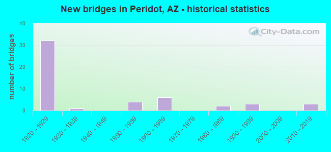
- New bridges - historical statistics
- 321920-1929
- 11930-1939
- 41950-1959
- 61960-1969
- 21980-1989
- 31990-1999
- 32010-2019


- Bridge Condition - Deck
- 3.7%Good
- 48.1%Satisfactory
- 33.3%Fair
- 14.8%Poor

- Bridge Condition - Superstructure
- 3.7%Very good
- 3.7%Good
- 40.7%Satisfactory
- 25.9%Fair
- 18.5%Poor
- 3.7%Critical
- 3.7%Imminent failure

- Bridge Condition - Substructure
- 7.4%Very good
- 70.4%Satisfactory
- 11.1%Fair
- 11.1%Poor

- Bridge Condition - Channel
- 6.1%Very good
- 20.4%Good
- 32.7%Satisfactory
- 32.7%Fair
- 8.2%Poor

- Bridge Condition - Culverts
- 4.3%Very good
- 47.8%Good
- 43.5%Satisfactory
- 4.3%Fair
Find on map >> Show street view
Structure Number: H58616B0822, Location: 18KM NW OF POINT OF PINES (Lat: 33.464306, Lng: -109.914556), Route carried "on" structure: Federal lands road 4, Year Built: 1990, Status: Open, Structure Length: 1.25m (4.10ft), Average Daily Traffic: 10 (year 2021), Truck Traffic: 2%, Average Future Daily Traffic: 11 (year 2038), Design Load: HS 25 or greater, Features Intersected: WASH
Minimum Vertical Clearance: 30+ m (98+ ft), Kilometerpoint: 97.700, Lanes on structure: 1, Owner: Bureau of Indian Affairs, Approaching Roadway Width: 4.0m (13.1ft), Material/Design: Aluminum, Iron, Design/Construction: Culvert, Number Of Spans In Main Unit: 2, Length of Maximum Span: 5.8m (19.0ft), Curb-To-Curb Width: 4.0m (13.1ft), Out-to-Out Width: 17.9m (58.7ft)
Condition: Channel: Satisfactory, Culverts: Satisfactory, Operating Rating: 55.5 metric tons, Method Used To Determine Operating Rating: Load Factor (LF), Inventory Rating: 40.8 metric tons, Method Used To Determine Inventory Rating: Load Factor (LF), Structural Evaluation: Equal to present minimum criteria, Deck Geometry: Somewhat better than minimum adequacy, Waterway Adequacy: Equal to present desirable criteria, Approach Roadway Alignment: Equal to present desirable criteria, Designated Inspection Frequency: Every 24 months, Inspection Date: December 2021
Find on map >> Show street view
Structure Number: H58616B0823, Location: 16 NW OF POINT OF PINES (Lat: 33.462111, Lng: -109.887444), Route carried "on" structure: Federal lands road 4, Year Built: 1990, Status: Open, Structure Length: 1.25m (4.10ft), Average Daily Traffic: 10 (year 2021), Truck Traffic: 2%, Average Future Daily Traffic: 11 (year 2038), Design Load: HS 25 or greater, Features Intersected: WASH
Minimum Vertical Clearance: 30+ m (98+ ft), Kilometerpoint: 95.000, Lanes on structure: 1, Owner: Bureau of Indian Affairs, Approaching Roadway Width: 4.0m (13.1ft), Skew: 2 degrees, Material/Design: Aluminum, Iron, Design/Construction: Culvert, Number Of Spans In Main Unit: 2, Length of Maximum Span: 5.8m (19.0ft), Curb-To-Curb Width: 4.0m (13.1ft), Out-to-Out Width: 22.0m (72.2ft)
Condition: Channel: Good, Culverts: Good, Operating Rating: 55.5 metric tons, Method Used To Determine Operating Rating: Load Factor (LF), Inventory Rating: 40.8 metric tons, Method Used To Determine Inventory Rating: Load Factor (LF), Structural Evaluation: Better than present minimum criteria, Deck Geometry: Somewhat better than minimum adequacy, Waterway Adequacy: Equal to present desirable criteria, Approach Roadway Alignment: Equal to present desirable criteria, Designated Inspection Frequency: Every 24 months, Inspection Date: December 2021
Find on map >> Show street view
Structure Number: H58616B0836, Location: 1.5 KM NW OF PERIDOT (Lat: 33.312333, Lng: -110.443444), Route carried "on" structure: Federal lands road 50, Year Built: 1980, Status: Open, Structure Length: 1.13m (3.71ft), Average Daily Traffic: 2,000 (year 2021), Truck Traffic: 5%, Average Future Daily Traffic: 2,500 (year 2038), Design Load: HS 20, Features Intersected: WASH, Facility Carried by Structure: IRR BIA 103
Minimum Vertical Clearance: 30+ m (98+ ft), Kilometerpoint: 2.000, Lanes on structure: 2, Owner: Bureau of Indian Affairs, Approaching Roadway Width: 7.3m (24.0ft), Skew: 3 degrees, Material/Design: Concrete, Design/Construction: Culvert, Number Of Spans In Main Unit: 3, Length of Maximum Span: 3.6m (11.8ft), Curb-To-Curb Width: 8.2m (26.9ft), Out-to-Out Width: 18.4m (60.4ft)
Condition: Channel: Fair, Culverts: Satisfactory, Operating Rating: 54.5 metric tons, Method Used To Determine Operating Rating: Load Factor (LF), Inventory Rating: 32.6 metric tons, Method Used To Determine Inventory Rating: Load Factor (LF), Structural Evaluation: Equal to present minimum criteria, Deck Geometry: Meets minimum limits, Waterway Adequacy: Better than present minimum criteria, Approach Roadway Alignment: Equal to present desirable criteria, Designated Inspection Frequency: Every 24 months, Inspection Date: December 2021
Find on map >> Show street view
Structure Number: H58616B0842, Location: 0.23KM SW OF US 70 (Lat: 33.115367, Lng: -110.108528), Route carried "on" structure: Federal lands road 194, Year Built: 2016, Status: Open, Structure Length: 2.54m (8.33ft), Average Daily Traffic: 500 (year 2021), Truck Traffic: 2%, Average Future Daily Traffic: 550 (year 2041), Design Load: HS 20, Features Intersected: LOCAL DRAINAGE
Minimum Vertical Clearance: 30+ m (98+ ft), Kilometerpoint: 0.230, Lanes on structure: 2, Owner: Bureau of Indian Affairs, Approaching Roadway Width: 13.0m (42.7ft), Skew: 2 degrees, Material/Design: Concrete, Design/Construction: Culvert, Number Of Spans In Main Unit: 7, Length of Maximum Span: 3.4m (11.2ft), Curb-To-Curb Width: 7.4m (24.3ft), Out-to-Out Width: 20.2m (66.3ft)
Condition: Channel: Good, Culverts: Good, Operating Rating: 62.5 metric tons, Method Used To Determine Operating Rating: Load and Resistance Factor (LRFR), Inventory Rating: 48.2 metric tons, Method Used To Determine Inventory Rating: Load and Resistance Factor (LRFR), Structural Evaluation: Better than present minimum criteria, Deck Geometry: Meets minimum limits, Waterway Adequacy: Equal to present desirable criteria, Approach Roadway Alignment: Equal to present desirable criteria, Designated Inspection Frequency: Every 24 months, Inspection Date: November 2021
Find on map >> Show street view
Structure Number: H58616B0844, Location: 2.27KM NORTH OF BIA RTE 8 (Lat: 33.079808, Lng: -110.133964), Route carried "on" structure: Federal lands road 193, Year Built: 2016, Status: Open, Structure Length: 0.78m (2.56ft), Average Daily Traffic: 500 (year 2021), Truck Traffic: 2%, Average Future Daily Traffic: 550 (year 2041), Features Intersected: LOCAL DRAINAGE
Minimum Vertical Clearance: 30+ m (98+ ft), Kilometerpoint: 2.270, Lanes on structure: 2, Owner: Bureau of Indian Affairs, Approaching Roadway Width: 8.0m (26.2ft), Material/Design: Steel, Design/Construction: Culvert, Number Of Spans In Main Unit: 5, Length of Maximum Span: 1.2m (3.9ft), Curb-To-Curb Width: 8.0m (26.2ft), Out-to-Out Width: 20.2m (66.3ft)
Condition: Channel: Good, Culverts: Very good, Operating Rating: 89.8 metric tons, Method Used To Determine Operating Rating: Load and Resistance Factor (LRFR), Inventory Rating: 89.8 metric tons, Method Used To Determine Inventory Rating: Load and Resistance Factor (LRFR), Structural Evaluation: Equal to present desirable criteria, Deck Geometry: Somewhat better than minimum adequacy, Waterway Adequacy: Equal to present desirable criteria, Approach Roadway Alignment: Equal to present desirable criteria, Designated Inspection Frequency: Every 24 months, Inspection Date: November 2021
Find on map >> Show street view
Structure Number: 477, Location: Jct SR 170 (Lat: 33.298000, Lng: -110.457500), Route carried "on" structure: US 70, Year Built: 1957, Status: Open, Structure Length: 6.25m (20.51ft), Average Daily Traffic: 6,169 (year 2019), Truck Traffic: 11%, Average Future Daily Traffic: 6,179 (year 2039), Design Load: HS 20, Features Intersected: RR & IRR SR 170
Minimum Vertical Clearance: 7.62m (25.00ft), Kilometerpoint: 436.567, Lanes on structure: 2, Lanes under structure: 2, Owner: State Highway Agency, Approaching Roadway Width: 10.4m (34.1ft), Material/Design: Steel continuous, Design/Construction: Stringer/Multi-beam, Number Of Spans In Main Unit: 4, Length of Maximum Span: 16.8m (55.1ft), Curb or Sidewalk Widths: Left: 1.8m (5.9ft), Right: 0.0m, Curb-To-Curb Width: 10.4m (34.1ft), Out-to-Out Width: 13.7m (44.9ft)
Condition: Deck: Fair, Superstructure: Satisfactory, Substructure: Satisfactory, Operating Rating: 50.8 metric tons, Method Used To Determine Operating Rating: Load Factor (LF), Inventory Rating: 30.8 metric tons, Method Used To Determine Inventory Rating: Load Factor (LF), Structural Evaluation: Equal to present minimum criteria, Deck Geometry: Meets minimum limits, Underclear: Equal to present desirable criteria, Approach Roadway Alignment: Equal to present desirable criteria, Designated Inspection Frequency: Every 24 months, Inspection Date: August 2021, Deck Structure Type: Concrete Cast-file-Place, Wearing Surface/Protective System: Wearing Surface: Bituminous
Find on map >> Show street view
Structure Number: 291, Location: 0.3 mi E Jct SR 170 (Lat: 33.297028, Lng: -110.453728), Route carried "on" structure: US 70, Year Built: 2012, Status: Open, Structure Length: 26.94m (88.39ft), Average Daily Traffic: 6,169 (year 2019), Truck Traffic: 10%, Average Future Daily Traffic: 8,550 (year 2040), Design Load: HL 93, Features Intersected: San Carlos River
Minimum Vertical Clearance: 30+ m (98+ ft), Kilometerpoint: 437.033, Lanes on structure: 2, Owner: State Highway Agency, Approaching Roadway Width: 14.6m (47.9ft), Material/Design: Prestressed concrete continuous, Design/Construction: Stringer/Multi-beam, Number Of Spans In Main Unit: 11, Length of Maximum Span: 24.4m (80.1ft), Curb or Sidewalk Widths: Left: 1.8m (5.9ft), Right: 0.0m, Curb-To-Curb Width: 14.6m (47.9ft), Out-to-Out Width: 17.6m (57.7ft)
Condition: Deck: Good, Superstructure: Very good, Substructure: Very good, Channel: Good, Operating Rating: 89.8 metric tons, Method Used To Determine Operating Rating: Load Factor (LF), Inventory Rating: 44.5 metric tons, Method Used To Determine Inventory Rating: Load Factor (LF), Structural Evaluation: Equal to present desirable criteria, Deck Geometry: Superior to present desirable criteria, Waterway Adequacy: Equal to present desirable criteria, Approach Roadway Alignment: Equal to present desirable criteria, Length Of Structure Improvement: 28.53m (93.60ft), Designated Inspection Frequency: Every 24 months, Inspection Date: October 2020, Bridge Improvement Cost: $3,000, Total Project Cost: $5,000 ( Estimate for 2020), Deck Structure Type: Concrete Cast-file-Place, Wearing Surface/Protective System: Wearing Surface: Monolithic Concrete
Find on map >> Show street view
Structure Number: 4282, Location: 2.2 mi E of Jct SR 170 (Lat: 33.291500, Lng: -110.424000), Route carried "on" structure: US 70, Year Built: 1957, Status: Open, Structure Length: 1.13m (3.71ft), Average Daily Traffic: 2,772 (year 2018), Truck Traffic: 22%, Average Future Daily Traffic: 2,782 (year 2038), Design Load: HS 20, Features Intersected: Wash
Minimum Vertical Clearance: 30+ m (98+ ft), Kilometerpoint: 439.721, Lanes on structure: 2, Owner: State Highway Agency, Approaching Roadway Width: 10.4m (34.1ft), Skew: 3 degrees, Material/Design: Concrete continuous, Design/Construction: Culvert, Number Of Spans In Main Unit: 3, Length of Maximum Span: 3.0m (9.8ft)
Condition: Channel: Good, Culverts: Good, Operating Rating: 89.8 metric tons, Method Used To Determine Operating Rating: Load Factor (LF), Inventory Rating: 89.8 metric tons, Method Used To Determine Inventory Rating: Load Factor (LF), Structural Evaluation: Better than present minimum criteria, Waterway Adequacy: Equal to present desirable criteria, Approach Roadway Alignment: Equal to present desirable criteria, Length Of Structure Improvement: 1.89m (6.20ft), Designated Inspection Frequency: Every 48 months, Inspection Date: April 2019, Total Project Cost: $1,000
Find on map >> Show street view
Structure Number: 4283, Location: 4.1 mi E Jct SR 170 (Lat: 33.287806, Lng: -110.390694), Route carried "on" structure: US 70, Year Built: 1957, Status: Open, Structure Length: 0.64m (2.10ft), Average Daily Traffic: 2,772 (year 2018), Truck Traffic: 22%, Average Future Daily Traffic: 2,782 (year 2038), Design Load: HS 20, Features Intersected: Wash
Minimum Vertical Clearance: 30+ m (98+ ft), Kilometerpoint: 442.859, Lanes on structure: 2, Owner: State Highway Agency, Approaching Roadway Width: 10.4m (34.1ft), Material/Design: Concrete continuous, Design/Construction: Culvert, Number Of Spans In Main Unit: 2, Length of Maximum Span: 3.0m (9.8ft)
Condition: Channel: Very good, Culverts: Good, Operating Rating: 89.8 metric tons, Method Used To Determine Operating Rating: Load Factor (LF), Inventory Rating: 89.8 metric tons, Method Used To Determine Inventory Rating: Load Factor (LF), Structural Evaluation: Better than present minimum criteria, Waterway Adequacy: Equal to present desirable criteria, Approach Roadway Alignment: Equal to present desirable criteria, Length Of Structure Improvement: 1.37m (4.49ft), Designated Inspection Frequency: Every 48 months, Inspection Date: April 2019, Total Project Cost: $1,000
Find on map >> Show street view
Structure Number: 477, Location: Jct SR 170 (Lat: 33.298000, Lng: -110.457500), Route carried "under" structure: State highway 170, Year Built: 1957, Structure Length: 0. m, Average Daily Traffic: 780 (year 2018), Truck Traffic: 9%, Features Intersected: RR & IRR SR 170, Facility Carried by Structure: IRR US 70
Minimum Vertical Clearance: 6.54m (21.46ft), Kilometerpoint: 436.229, Lanes on structure: 2, Lanes under structure: 2, Material/Design: Steel continuous, Design/Construction: Stringer/Multi-beam, Length of Maximum Span: 16.8m (55.1ft)