Bridge Statistics for Perth Amboy, New Jersey (NJ)
Condition, Traffic, Stress, Structural Evaluation, Project Costs
- National Bridge Inventory (NBI) Statistics
- 61Number of bridges
- 1,982ft / 604mTotal length
- $382,090,000Total costs
- 1,533,262Total average daily traffic
- 70,252Total average daily truck traffic
- National Bridge Inventory (NBI) Registered Bridges for Perth Amboy
- No street view available for this location
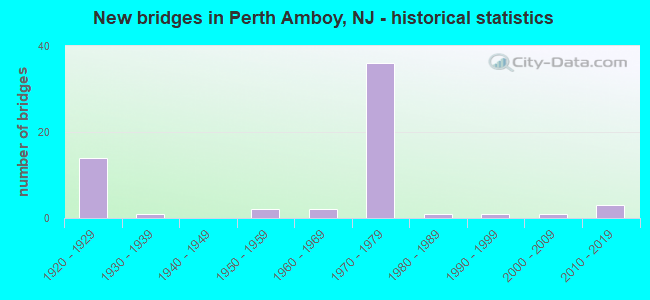
- New bridges - historical statistics
- 141920-1929
- 11930-1939
- 21950-1959
- 21960-1969
- 361970-1979
- 11980-1989
- 11990-1999
- 12000-2009
- 32010-2019

- Reconstructed bridges - Historical Statistics
- 31950-1959
- 11960-1969
- 01970-1979
- 11980-1989
- 31990-1999
- 22000-2009
- 22010-2019
- 12020-2022


- Bridge Condition - Deck
- 10.0%Very good
- 30.0%Good
- 16.7%Satisfactory
- 30.0%Fair
- 6.7%Poor
- 6.7%Serious

- Bridge Condition - Superstructure
- 3.3%Very good
- 30.0%Good
- 26.7%Satisfactory
- 30.0%Fair
- 6.7%Poor
- 3.3%Serious

- Bridge Condition - Substructure
- 30.0%Good
- 46.7%Satisfactory
- 16.7%Fair
- 6.7%Poor

- Bridge Condition - Channel
- 25.0%Very good
- 75.0%Good
Find on map >> Show street view
Structure Number: 1232161, Location: NJ440 MP4.26 StateSt Exit (Lat: 40.526619, Lng: -74.262669), Route carried "under" structure: Ramp State highway 440, Year Built: 2013, Structure Length: 0. m, Average Daily Traffic: 5,380 (year 2021), Truck Traffic: 5%, Features Intersected: NJ 440 Ramp U and ramp V
Minimum Vertical Clearance: 5.74m (18.83ft), Kilometerpoint: 6.856, Lanes on structure: 2, Lanes under structure: 2, Material/Design: Steel continuous, Design/Construction: Stringer/Multi-beam, Length of Maximum Span: 31.4m (103.0ft)
Find on map >> Show street view
Structure Number: 1232161, Location: NJ440 MP4.26 StateSt Exit (Lat: 40.526619, Lng: -74.262669), Route carried "under" structure: Ramp State highway 440, Year Built: 2013, Structure Length: 0. m, Average Daily Traffic: 5,380 (year 2021), Truck Traffic: 5%, Features Intersected: NJ 440 Ramp U and ramp V
Minimum Vertical Clearance: 6.25m (20.51ft), Kilometerpoint: 6.856, Lanes on structure: 2, Lanes under structure: 2, Material/Design: Steel continuous, Design/Construction: Stringer/Multi-beam, Length of Maximum Span: 31.4m (103.0ft)
Find on map >> Show street view
Structure Number: 1234173, Location: 0.20 MI EAST OF US9 (Lat: 40.515631, Lng: -74.296800), Route carried "under" structure: Ramp State highway 9, Year Built: 1972, Structure Length: 0. m, Average Daily Traffic: 1,494 (year 2020), Truck Traffic: 5%, Features Intersected: RAMP FOR US 9 & NJ 440, Facility Carried by Structure: CR 656 (SMITH ST)
Minimum Vertical Clearance: 4.57m (14.99ft), Kilometerpoint: 213.721, Lanes on structure: 5, Lanes under structure: 2, Material/Design: Steel, Design/Construction: Stringer/Multi-beam, Length of Maximum Span: 28.0m (91.9ft)
Find on map >> Show street view
Structure Number: 1234177, Location: 0.65 MI EAST OF GSP (Lat: 40.522800, Lng: -74.291150), Route carried "under" structure: State highway 440, Year Built: 1972, Structure Length: 0. m, Average Daily Traffic: 88,138 (year 2021), Truck Traffic: 5%, Features Intersected: NJ 440 & RAMP TO 440N, Facility Carried by Structure: NEW BRUNSWICK AVE.
Minimum Vertical Clearance: 5.51m (18.08ft), Kilometerpoint: 4.281, Lanes on structure: 2, Lanes under structure: 6, Material/Design: Steel, Design/Construction: Stringer/Multi-beam, Length of Maximum Span: 34.1m (111.9ft)
Find on map >> Show street view
Structure Number: 1234177, Location: 0.65 MI EAST OF GSP (Lat: 40.522800, Lng: -74.291150), Route carried "under" structure: Ramp State highway 440, Year Built: 1972, Structure Length: 0. m, Average Daily Traffic: 17,330 (year 2021), Truck Traffic: 5%, Features Intersected: NJ 440 & RAMP TO 440N, Facility Carried by Structure: NEW BRUNSWICK AVE.
Minimum Vertical Clearance: 4.50m (14.76ft), Kilometerpoint: 4.281, Lanes on structure: 2, Lanes under structure: 1, Material/Design: Steel, Design/Construction: Stringer/Multi-beam, Length of Maximum Span: 34.1m (111.9ft)
Find on map >> Show street view
Structure Number: 1234178, Location: 0.81 MI EAST OF GSP (Lat: 40.525119, Lng: -74.289289), Route carried "under" structure: State highway 440, Year Built: 1972, Structure Length: 0. m, Average Daily Traffic: 108,895 (year 2021), Truck Traffic: 4%, Features Intersected: NJ 440, Facility Carried by Structure: FLRD.GRV RD(CR655)
Minimum Vertical Clearance: 4.55m (14.93ft), Kilometerpoint: 4.538, Lanes on structure: 4, Lanes under structure: 7, Material/Design: Steel, Design/Construction: Stringer/Multi-beam, Length of Maximum Span: 26.2m (86.0ft)
Find on map >> Show street view
Structure Number: 1234179, Location: 1.05 MI N OF US 9 JCT (Lat: 40.528189, Lng: -74.285700), Route carried "under" structure: State highway 440, Year Built: 1972, Structure Length: 0. m, Average Daily Traffic: 100,001 (year 2021), Truck Traffic: 5%, Features Intersected: NJ 440, Facility Carried by Structure: CARLOCK AVENUE
Minimum Vertical Clearance: 4.93m (16.17ft), Kilometerpoint: 4.973, Lanes on structure: 2, Lanes under structure: 10, Material/Design: Steel, Design/Construction: Stringer/Multi-beam, Length of Maximum Span: 36.0m (118.1ft)
Find on map >> Show street view
Structure Number: 1241151, Location: 1.1 MI E. OF GSP (Lat: 40.528581, Lng: -74.282939), Route carried "under" structure: State highway 440, Year Built: 1972, Structure Length: 0. m, Average Daily Traffic: 84,020 (year 2020), Truck Traffic: 5%, Features Intersected: NJ 440, Facility Carried by Structure: NJ 184 EB
Minimum Vertical Clearance: 4.63m (15.19ft), Kilometerpoint: 5.230, Lanes on structure: 3, Lanes under structure: 6, Material/Design: Steel, Design/Construction: Stringer/Multi-beam, Length of Maximum Span: 39.6m (129.9ft)
Find on map >> Show street view
Structure Number: 1241151, Location: 1.1 MI E. OF GSP (Lat: 40.528581, Lng: -74.282939), Route carried "under" structure: Ramp State highway 440, Year Built: 1972, Structure Length: 0. m, Average Daily Traffic: 5,205 (year 2020), Truck Traffic: 5%, Features Intersected: NJ 440, Facility Carried by Structure: NJ 184 EB
Minimum Vertical Clearance: 4.57m (14.99ft), Kilometerpoint: 5.230, Lanes on structure: 3, Lanes under structure: 2, Material/Design: Steel, Design/Construction: Stringer/Multi-beam, Length of Maximum Span: 39.6m (129.9ft)
Find on map >> Show street view
Structure Number: 382306A, Location: 3 miles north of NJ TRPK (Lat: 40.525169, Lng: -74.239289), Route carried "under" structure: Spur City street , Year Built: 1928, Structure Length: 0. m, Average Daily Traffic: 600 (year 1991), Truck Traffic: 2%, Features Intersected: Arthur Kill Road, Facility Carried by Structure: Spur County highway 440
Minimum Vertical Clearance: 5.31m (17.42ft), Kilometerpoint: 32.718, Lanes on structure: 4, Lanes under structure: 2, Material/Design: Steel, Design/Construction: Girder and Floorbeam System, Length of Maximum Span: 35.1m (115.2ft)
Find on map >> Show street view
Structure Number: 382306B, Location: 3 miles north of NJ TRPK (Lat: 40.524469, Lng: -74.252281), Route carried "under" structure: ServiceCity street , Year Built: 1928, Structure Length: 0. m, Average Daily Traffic: 50 (year 1992), Truck Traffic: 1%, Features Intersected: State Street Ramp, Facility Carried by Structure: Spur County highway 440
Minimum Vertical Clearance: 4.04m (13.25ft), Kilometerpoint: 0.000, Lanes on structure: 4, Lanes under structure: 2, Material/Design: Steel, Design/Construction: Girder and Floorbeam System, Length of Maximum Span: 31.7m (104.0ft)
Find on map >> Show street view
Structure Number: 382306B, Location: 3 miles north of NJ TRPK (Lat: 40.524469, Lng: -74.252281), Route carried "under" structure: Alternate County highway 611, Year Built: 1928, Structure Length: 0. m, Average Daily Traffic: 6,184 (year 2014), Truck Traffic: 2%, Features Intersected: State Street Ramp, Facility Carried by Structure: Spur County highway 440
Minimum Vertical Clearance: 4.67m (15.32ft), Kilometerpoint: 0.000, Lanes on structure: 4, Lanes under structure: 2, Material/Design: Steel, Design/Construction: Girder and Floorbeam System, Length of Maximum Span: 31.7m (104.0ft)
Find on map >> Show street view
Structure Number: 382306B, Location: 3 miles north of NJ TRPK (Lat: 40.524469, Lng: -74.252281), Route carried "under" structure: Ramp Other road , Year Built: 1928, Structure Length: 0. m, Average Daily Traffic: 50 (year 1992), Truck Traffic: 1%, Features Intersected: State Street Ramp, Facility Carried by Structure: Spur County highway 440
Minimum Vertical Clearance: 4.04m (13.25ft), Kilometerpoint: 6.920, Lanes on structure: 4, Lanes under structure: 2, Material/Design: Steel, Design/Construction: Girder and Floorbeam System, Length of Maximum Span: 31.7m (104.0ft)
Find on map >> Show street view
Structure Number: M09208, Location: 1.8 MI E RTE 444 & NJ TPK (Lat: 40.516667, Lng: -74.276667), Route carried "under" structure: Interstate 95, Year Built: 1950, Structure Length: 0. m, Average Daily Traffic: 207,684 (year 2021), Truck Traffic: 9%, Features Intersected: NJ TURNPIKE, Facility Carried by Structure: FULTON STREET
Minimum Vertical Clearance: 4.93m (16.17ft), Kilometerpoint: 75.172, Lanes on structure: 2, Lanes under structure: 14, Toll: On toll road, Material/Design: Steel, Design/Construction: Stringer/Multi-beam, Length of Maximum Span: 25.9m (85.0ft)