Bridge Statistics for Phenix City, Alabama (AL)
Condition, Traffic, Stress, Structural Evaluation, Project Costs
- National Bridge Inventory (NBI) Statistics
- 88Number of bridges
- 1,358ft / 414mTotal length
- $167,952,000Total costs
- 813,451Total average daily traffic
- 66,645Total average daily truck traffic
- National Bridge Inventory (NBI) Registered Bridges for Phenix City
- No street view available for this location
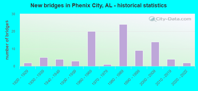
- New bridges - historical statistics
- 21920-1929
- 51930-1939
- 41940-1949
- 31950-1959
- 201960-1969
- 11970-1979
- 241980-1989
- 91990-1999
- 142000-2009
- 42010-2019
- 22020-2022
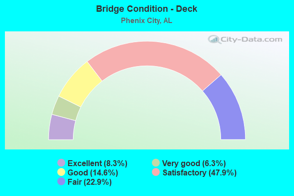
- Bridge Condition - Deck
- 8.3%Excellent
- 6.3%Very good
- 14.6%Good
- 47.9%Satisfactory
- 22.9%Fair

- Bridge Condition - Superstructure
- 8.3%Excellent
- 12.5%Very good
- 31.3%Good
- 35.4%Satisfactory
- 12.5%Fair

- Bridge Condition - Substructure
- 8.3%Excellent
- 12.5%Very good
- 37.5%Good
- 29.2%Satisfactory
- 10.4%Fair
- 2.1%Poor
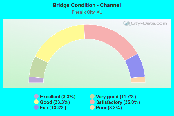
- Bridge Condition - Channel
- 3.3%Excellent
- 11.7%Very good
- 33.3%Good
- 35.0%Satisfactory
- 13.3%Fair
- 3.3%Poor
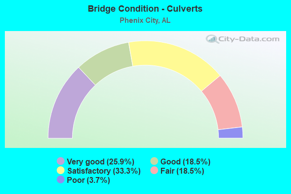
- Bridge Condition - Culverts
- 25.9%Very good
- 18.5%Good
- 33.3%Satisfactory
- 18.5%Fair
- 3.7%Poor
Find on map >> Show street view
Structure Number: 13898, Location: 4.4 MI E OF JCT US 431 (Lat: 32.505803, Lng: -85.003619), Route carried "on" structure: US 80, Year Built: 1986, Status: Open, Structure Length: 6.55m (21.49ft), Average Daily Traffic: 24,800 (year 2013), Truck Traffic: 8%, Average Future Daily Traffic: 32,428 (year 2033), Design Load: HS 20, Features Intersected: RIVERCHASE DRIVE-5TH AVE
Minimum Vertical Clearance: 30+ m (98+ ft), Kilometerpoint: 349.836, Lanes on structure: 3, Lanes under structure: 3, Base Highway Network: Yes, Owner: State Highway Agency, Approaching Roadway Width: 12.2m (40.0ft), Skew: 2 degrees, Material/Design: Prestressed concrete, Design/Construction: Stringer/Multi-beam, Number Of Spans In Main Unit: 3, Length of Maximum Span: 24.1m (79.1ft), Curb-To-Curb Width: 12.2m (40.0ft), Out-to-Out Width: 13.0m (42.7ft)
Condition: Deck: Satisfactory, Superstructure: Good, Substructure: Satisfactory, Operating Rating: 45.0 metric tons, Method Used To Determine Operating Rating: Load Factor (LF), Inventory Rating: 31.9 metric tons, Method Used To Determine Inventory Rating: Load Factor (LF), Structural Evaluation: Equal to present minimum criteria, Deck Geometry: Meets minimum limits, Underclear: Superior to present desirable criteria, Approach Roadway Alignment: Better than present minimum criteria, Length Of Structure Improvement: 7.59m (24.90ft), Designated Inspection Frequency: Every 24 months, Inspection Date: August 2021, Bridge Improvement Cost: $2,186,000, Roadway Improvement Cost: $219,000, Total Project Cost: $2,405,000 ( Estimate for 2022), Deck Structure Type: Concrete Cast-file-Place
Find on map >> Show street view
Structure Number: 13899, Location: 4.4 MI E OF US 431 (Lat: 32.506014, Lng: -85.003611), Route carried "on" structure: US 80, Year Built: 1986, Status: Open, Structure Length: 6.68m (21.92ft), Average Daily Traffic: 24,800 (year 2013), Truck Traffic: 8%, Average Future Daily Traffic: 32,428 (year 2033), Design Load: HS 20, Features Intersected: RIVERCHASE DRIVE-5TH AVE
Minimum Vertical Clearance: 30+ m (98+ ft), Kilometerpoint: 349.836, Lanes on structure: 3, Lanes under structure: 3, Base Highway Network: Yes, Owner: State Highway Agency, Approaching Roadway Width: 12.2m (40.0ft), Skew: 2 degrees, Material/Design: Prestressed concrete, Design/Construction: Stringer/Multi-beam, Number Of Spans In Main Unit: 3, Length of Maximum Span: 24.7m (81.0ft), Curb-To-Curb Width: 12.2m (40.0ft), Out-to-Out Width: 13.0m (42.7ft)
Condition: Deck: Satisfactory, Superstructure: Good, Substructure: Satisfactory, Operating Rating: 45.0 metric tons, Method Used To Determine Operating Rating: Load Factor (LF), Inventory Rating: 31.9 metric tons, Method Used To Determine Inventory Rating: Load Factor (LF), Structural Evaluation: Equal to present minimum criteria, Deck Geometry: Meets minimum limits, Underclear: Superior to present desirable criteria, Approach Roadway Alignment: Better than present minimum criteria, Length Of Structure Improvement: 7.72m (25.33ft), Designated Inspection Frequency: Every 24 months, Inspection Date: August 2021, Bridge Improvement Cost: $2,223,000, Roadway Improvement Cost: $222,000, Total Project Cost: $2,445,000 ( Estimate for 2022), Deck Structure Type: Concrete Cast-file-Place
Find on map >> Show street view
Structure Number: 14513, Location: 0.15 MI E OF INT US 431 (Lat: 32.488389, Lng: -85.031583), Route carried "on" structure: Ramp US 80, Year Built: 1988, Status: Open, Structure Length: 1.66m (5.45ft), Average Daily Traffic: 3,415 (year 2013), Truck Traffic: 4%, Average Future Daily Traffic: 4,465 (year 2033), Design Load: HS 20, Features Intersected: HOLLAND CREEK
Minimum Vertical Clearance: 30+ m (98+ ft), Kilometerpoint: 346.595, Lanes on structure: 4, Owner: State Highway Agency, Approaching Roadway Width: 12.2m (40.0ft), Skew: 2 degrees, Material/Design: Concrete, Design/Construction: Culvert, Number Of Spans In Main Unit: 4, Length of Maximum Span: 3.9m (12.8ft)
Condition: Channel: Satisfactory, Culverts: Satisfactory, Operating Rating: 88.9 metric tons, Method Used To Determine Operating Rating: Load Factor (LF), Inventory Rating: 88.9 metric tons, Method Used To Determine Inventory Rating: Load Factor (LF), Structural Evaluation: Equal to present minimum criteria, Waterway Adequacy: Superior to present desirable criteria, Approach Roadway Alignment: Equal to present minimum criteria, Length Of Structure Improvement: 2.34m (7.68ft), Designated Inspection Frequency: Every 24 months, Inspection Date: August 2021, Bridge Improvement Cost: $9,843,000, Roadway Improvement Cost: $984,000, Total Project Cost: $10,827,000 ( Estimate for 2022)
Find on map >> Show street view
Structure Number: 14514, Location: 0.15 MI E OF INT US 431 (Lat: 32.488389, Lng: -85.031583), Route carried "on" structure: Ramp US 80, Year Built: 1988, Status: Open, Structure Length: 2.06m (6.76ft), Average Daily Traffic: 3,415 (year 2013), Truck Traffic: 4%, Average Future Daily Traffic: 4,465 (year 2033), Design Load: HS 20, Features Intersected: MILL CREEK
Minimum Vertical Clearance: 30+ m (98+ ft), Kilometerpoint: 346.595, Lanes on structure: 2, Owner: State Highway Agency, Approaching Roadway Width: 11.3m (37.1ft), Material/Design: Concrete, Design/Construction: Culvert, Number Of Spans In Main Unit: 5, Length of Maximum Span: 3.7m (12.1ft)
Condition: Channel: Good, Culverts: Fair, Operating Rating: 88.9 metric tons, Method Used To Determine Operating Rating: Load Factor (LF), Inventory Rating: 88.9 metric tons, Method Used To Determine Inventory Rating: Load Factor (LF), Structural Evaluation: Somewhat better than minimum adequacy, Waterway Adequacy: Superior to present desirable criteria, Approach Roadway Alignment: Better than present minimum criteria, Length Of Structure Improvement: 2.83m (9.28ft), Designated Inspection Frequency: Every 24 months, Inspection Date: Febuary 2021, Bridge Improvement Cost: $3,019,000, Roadway Improvement Cost: $302,000, Total Project Cost: $3,321,000 ( Estimate for 2022)
Find on map >> Show street view
Structure Number: 14515, Location: 0.16 MI E OF INT US 431 (Lat: 32.490272, Lng: -85.030581), Route carried "on" structure: US 80, Year Built: 1988, Status: Open, Structure Length: 8.90m (29.20ft), Average Daily Traffic: 17,075 (year 2013), Truck Traffic: 4%, Average Future Daily Traffic: 22,327 (year 2033), Design Load: HS 20, Features Intersected: OPELIKA RD * NORFOLK SOU
Minimum Vertical Clearance: 30+ m (98+ ft), Kilometerpoint: 346.724, Lanes on structure: 2, Lanes under structure: 2, Base Highway Network: Yes, Owner: State Highway Agency, Approaching Roadway Width: 12.2m (40.0ft), Material/Design: Prestressed concrete, Design/Construction: Stringer/Multi-beam, Number Of Spans In Main Unit: 5, Length of Maximum Span: 24.4m (80.1ft), Curb-To-Curb Width: 15.8m (51.8ft), Out-to-Out Width: 16.7m (54.8ft)
Condition: Deck: Fair, Superstructure: Good, Substructure: Good, Operating Rating: 51.5 metric tons, Method Used To Determine Operating Rating: Load Factor (LF), Inventory Rating: 30.8 metric tons, Method Used To Determine Inventory Rating: Load Factor (LF), Structural Evaluation: Better than present minimum criteria, Deck Geometry: Superior to present desirable criteria, Underclear: Superior to present desirable criteria, Approach Roadway Alignment: Somewhat better than minimum adequacy, Length Of Structure Improvement: 9.87m (32.38ft), Designated Inspection Frequency: Every 24 months, Inspection Date: January 2022, Bridge Improvement Cost: $3,656,000, Roadway Improvement Cost: $366,000, Total Project Cost: $4,022,000 ( Estimate for 2022), Deck Structure Type: Concrete Cast-file-Place
Find on map >> Show street view
Structure Number: 14516, Location: 0.16 MI E OF INT US 431 (Lat: 32.490128, Lng: -85.030403), Route carried "on" structure: US 80, Year Built: 1988, Status: Open, Structure Length: 8.90m (29.20ft), Average Daily Traffic: 17,075 (year 2013), Truck Traffic: 4%, Average Future Daily Traffic: 22,327 (year 2033), Design Load: HS 20, Features Intersected: OPELIKA RD * NORFOLK SOU
Minimum Vertical Clearance: 30+ m (98+ ft), Kilometerpoint: 346.724, Lanes on structure: 2, Lanes under structure: 2, Base Highway Network: Yes, Owner: State Highway Agency, Approaching Roadway Width: 12.2m (40.0ft), Material/Design: Prestressed concrete, Design/Construction: Stringer/Multi-beam, Number Of Spans In Main Unit: 5, Length of Maximum Span: 24.4m (80.1ft), Curb-To-Curb Width: 15.8m (51.8ft), Out-to-Out Width: 16.7m (54.8ft)
Condition: Deck: Fair, Superstructure: Satisfactory, Substructure: Good, Operating Rating: 51.5 metric tons, Method Used To Determine Operating Rating: Load Factor (LF), Inventory Rating: 30.8 metric tons, Method Used To Determine Inventory Rating: Load Factor (LF), Structural Evaluation: Equal to present minimum criteria, Deck Geometry: Superior to present desirable criteria, Underclear: High priority of corrective action, Approach Roadway Alignment: Somewhat better than minimum adequacy, Length Of Structure Improvement: 9.87m (32.38ft), Designated Inspection Frequency: Every 24 months, Inspection Date: January 2022, Bridge Improvement Cost: $3,656,000, Roadway Improvement Cost: $366,000, Total Project Cost: $4,022,000 ( Estimate for 2022), Deck Structure Type: Concrete Cast-file-Place
Find on map >> Show street view
Structure Number: 15594, Location: JCT 13TH * 28TH (Lat: 32.471667, Lng: -85.031667), Route carried "on" structure: City street , Year Built: 1960, Status: Open, Structure Length: 0.72m (2.36ft), Average Daily Traffic: 1,000 (year 2022), Truck Traffic: 1%, Average Future Daily Traffic: 2,000 (year 2042), Design Load: H 15, Features Intersected: TRIB HOLLAND CREEK, Facility Carried by Structure: 28TH AVENUE
Minimum Vertical Clearance: 30+ m (98+ ft), Kilometerpoint: 1.099, Lanes on structure: 2, Owner: City or Municipal Highway Agency, Approaching Roadway Width: 6.7m (22.0ft), Skew: 4 degrees, Material/Design: Concrete, Design/Construction: Culvert, Number Of Spans In Main Unit: 2, Length of Maximum Span: 3.7m (12.1ft), Curb or Sidewalk Widths: Left: 0.2m (0.7ft), Right: 0.2m (0.7ft), Curb-To-Curb Width: 6.1m (20.0ft), Out-to-Out Width: 7.3m (24.0ft)
Condition: Channel: Fair, Culverts: Satisfactory, Operating Rating: 40.6 metric tons, Method Used To Determine Operating Rating: Load Factor (LF), Inventory Rating: 24.3 metric tons, Method Used To Determine Inventory Rating: Load Factor (LF), Structural Evaluation: Equal to present minimum criteria, Deck Geometry: High priority of corrective action, Waterway Adequacy: Better than present minimum criteria, Approach Roadway Alignment: Equal to present minimum criteria, Length Of Structure Improvement: 1.36m (4.46ft), Designated Inspection Frequency: Every 24 months, Inspection Date: January 2022, Bridge Improvement Cost: $283,000, Roadway Improvement Cost: $28,000, Total Project Cost: $311,000 ( Estimate for 2022), Wearing Surface/Protective System: Wearing Surface: Bituminous
Find on map >> Show street view
Structure Number: 15595, Location: 500 N. 13TH STREET (Lat: 32.473333, Lng: -85.031667), Route carried "on" structure: City street , Year Built: 1960, Status: Posted for load, Structure Length: 0.73m (2.40ft), Average Daily Traffic: 1,000 (year 2021), Truck Traffic: 1%, Average Future Daily Traffic: 2,000 (year 2041), Design Load: H 15, Features Intersected: TRIB HOLLAND CREEK, Facility Carried by Structure: 28TH AVENUE
Minimum Vertical Clearance: 30+ m (98+ ft), Kilometerpoint: 0.999, Lanes on structure: 2, Owner: City or Municipal Highway Agency, Approaching Roadway Width: 6.7m (22.0ft), Skew: 4 degrees, Material/Design: Concrete, Design/Construction: Culvert, Number Of Spans In Main Unit: 2, Length of Maximum Span: 3.7m (12.1ft), Curb or Sidewalk Widths: Left: 0.2m (0.7ft), Right: 0.2m (0.7ft), Curb-To-Curb Width: 5.8m (19.0ft), Out-to-Out Width: 7.3m (24.0ft)
Condition: Channel: Poor, Culverts: Poor, Operating Rating: 18.1 metric tons, Method Used To Determine Operating Rating: Load Factor (LF), Inventory Rating: 13.6 metric tons, Method Used To Determine Inventory Rating: Load Factor (LF), Structural Evaluation: Meets minimum limits, Deck Geometry: High priority of replacement, Waterway Adequacy: Better than present minimum criteria, Approach Roadway Alignment: Better than present minimum criteria, Bridge Posting: Required (Relationship of Operating Rating to Maximum Legal Load: > 39.9% below), Length Of Structure Improvement: 1.38m (4.53ft), Designated Inspection Frequency: Every 24 months, Other Special Inspection Frequency: Every 12 months, Inspection Date: November 2020, Other Special Inspection Date: November 2021, Bridge Improvement Cost: $286,000, Roadway Improvement Cost: $29,000, Total Project Cost: $315,000 ( Estimate for 2022), Wearing Surface/Protective System: Wearing Surface: Bituminous
Find on map >> Show street view
Structure Number: 15931, Location: PHENIX CITY (Lat: 32.490000, Lng: -85.031667), Route carried "on" structure: City street 7, Year Built: 1994, Status: Open, Structure Length: 1.58m (5.18ft), Average Daily Traffic: 2,905 (year 2022), Truck Traffic: 5%, Average Future Daily Traffic: 4,457 (year 2042), Design Load: HS 20, Features Intersected: HOLLAND CREEK, Facility Carried by Structure: SOUTH RAILROAD ST
Minimum Vertical Clearance: 30+ m (98+ ft), Kilometerpoint: 1.199, Lanes on structure: 2, Owner: City or Municipal Highway Agency, Approaching Roadway Width: 9.8m (32.2ft), Material/Design: Concrete, Design/Construction: Culvert, Number Of Spans In Main Unit: 4, Length of Maximum Span: 3.7m (12.1ft), Curb-To-Curb Width: 9.8m (32.2ft), Out-to-Out Width: 10.7m (35.1ft)
Condition: Channel: Good, Culverts: Very good, Operating Rating: 88.9 metric tons, Method Used To Determine Operating Rating: Load Factor (LF), Inventory Rating: 60.1 metric tons, Method Used To Determine Inventory Rating: Load Factor (LF), Structural Evaluation: Equal to present desirable criteria, Deck Geometry: Meets minimum limits, Waterway Adequacy: Equal to present desirable criteria, Approach Roadway Alignment: Superior to present desirable criteria, Length Of Structure Improvement: 2.26m (7.41ft), Designated Inspection Frequency: Every 24 months, Inspection Date: January 2022, Bridge Improvement Cost: $653,000, Roadway Improvement Cost: $65,000, Total Project Cost: $718,000 ( Estimate for 2022), Wearing Surface/Protective System: Wearing Surface: Bituminous
Find on map >> Show street view
Structure Number: 16052, Location: PHENIX CITY (Lat: 32.477003, Lng: -85.002089), Route carried "on" structure: City street , Year Built: 1994, Status: Open, Structure Length: 4.63m (15.19ft), Average Daily Traffic: 9,958 (year 2018), Truck Traffic: 2%, Average Future Daily Traffic: 13,683 (year 2038), Design Load: HS 20, Features Intersected: CSX RAILROAD, Facility Carried by Structure: SUMMERVILLE RD.
Minimum Vertical Clearance: 30.18m (99.02ft), Kilometerpoint: 0.100, Lanes on structure: 2, Owner: City or Municipal Highway Agency, Approaching Roadway Width: 8.6m (28.2ft), Skew: 3 degrees, Material/Design: Prestressed concrete, Design/Construction: Stringer/Multi-beam, Number Of Spans In Main Unit: 3, Length of Maximum Span: 18.2m (59.7ft), Curb or Sidewalk Widths: Left: 1.5m (4.9ft), Right: 1.5m (4.9ft), Curb-To-Curb Width: 8.6m (28.2ft), Out-to-Out Width: 12.4m (40.7ft)
Condition: Deck: Good, Superstructure: Very good, Substructure: Very good, Operating Rating: 68.1 metric tons, Method Used To Determine Operating Rating: Load Factor (LF), Inventory Rating: 40.8 metric tons, Method Used To Determine Inventory Rating: Load Factor (LF), Structural Evaluation: Equal to present desirable criteria, Deck Geometry: High priority of replacement, Underclear: Superior to present desirable criteria, Approach Roadway Alignment: Equal to present desirable criteria, Length Of Structure Improvement: 5.63m (18.47ft), Designated Inspection Frequency: Every 24 months, Inspection Date: April 2020, Bridge Improvement Cost: $1,545,000, Roadway Improvement Cost: $155,000, Total Project Cost: $1,700,000 ( Estimate for 2022), Deck Structure Type: Concrete Cast-file-Place
Find on map >> Show street view
Structure Number: 1625, Location: 6.17 MI N JCT SR169 (Lat: 32.380483, Lng: -85.084161), Route carried "on" structure: US 431, Year Built: 1995, Status: Open, Structure Length: 9.27m (30.41ft), Average Daily Traffic: 5,465 (year 2013), Truck Traffic: 11%, Average Future Daily Traffic: 7,076 (year 2033), Design Load: HS 20, Features Intersected: LITTLE UCHEE CREEK
Minimum Vertical Clearance: 30+ m (98+ ft), Kilometerpoint: 169.593, Lanes on structure: 2, Base Highway Network: Yes, Owner: State Highway Agency, Approaching Roadway Width: 12.2m (40.0ft), Material/Design: Prestressed concrete, Design/Construction: Stringer/Multi-beam, Number Of Spans In Main Unit: 5, Length of Maximum Span: 42.7m (140.1ft), Curb-To-Curb Width: 12.2m (40.0ft), Out-to-Out Width: 13.0m (42.7ft)
Condition: Deck: Satisfactory, Superstructure: Satisfactory, Substructure: Good, Channel: Good, Operating Rating: 52.3 metric tons, Method Used To Determine Operating Rating: Load Factor (LF), Inventory Rating: 26.1 metric tons, Method Used To Determine Inventory Rating: Load Factor (LF), Structural Evaluation: Equal to present minimum criteria, Deck Geometry: Better than present minimum criteria, Waterway Adequacy: Better than present minimum criteria, Approach Roadway Alignment: Equal to present desirable criteria, Length Of Structure Improvement: 10.23m (33.56ft), Designated Inspection Frequency: Every 24 months, Inspection Date: July 2020, Bridge Improvement Cost: $2,946,000, Roadway Improvement Cost: $295,000, Total Project Cost: $3,241,000 ( Estimate for 2022), Deck Structure Type: Concrete Cast-file-Place
Find on map >> Show street view
Structure Number: 16251, Location: 6.17 MI N JCT SR169 (Lat: 32.380633, Lng: -85.084408), Route carried "on" structure: US 431, Year Built: 1995, Status: Open, Structure Length: 9.27m (30.41ft), Average Daily Traffic: 5,465 (year 2013), Truck Traffic: 11%, Average Future Daily Traffic: 7,076 (year 2033), Design Load: HS 20, Features Intersected: LITTLE UCHEE CREEK
Minimum Vertical Clearance: 30+ m (98+ ft), Kilometerpoint: 169.593, Lanes on structure: 2, Base Highway Network: Yes, Owner: State Highway Agency, Approaching Roadway Width: 12.2m (40.0ft), Material/Design: Prestressed concrete, Design/Construction: Stringer/Multi-beam, Number Of Spans In Main Unit: 5, Length of Maximum Span: 42.7m (140.1ft), Curb-To-Curb Width: 12.2m (40.0ft), Out-to-Out Width: 13.0m (42.7ft)
Condition: Deck: Satisfactory, Superstructure: Satisfactory, Substructure: Good, Channel: Good, Operating Rating: 52.3 metric tons, Method Used To Determine Operating Rating: Load Factor (LF), Inventory Rating: 26.1 metric tons, Method Used To Determine Inventory Rating: Load Factor (LF), Structural Evaluation: Equal to present minimum criteria, Deck Geometry: Better than present minimum criteria, Waterway Adequacy: Better than present minimum criteria, Approach Roadway Alignment: Equal to present desirable criteria, Length Of Structure Improvement: 10.23m (33.56ft), Designated Inspection Frequency: Every 24 months, Inspection Date: July 2020, Bridge Improvement Cost: $2,946,000, Roadway Improvement Cost: $295,000, Total Project Cost: $3,241,000 ( Estimate for 2022), Deck Structure Type: Concrete Cast-file-Place
Find on map >> Show street view
Structure Number: 16252, Location: 4.13MI N JCT SR 169 (Lat: 32.359183, Lng: -85.107889), Route carried "on" structure: US 431, Year Built: 1995, Status: Open, Structure Length: 9.94m (32.61ft), Average Daily Traffic: 4,910 (year 2013), Truck Traffic: 9%, Average Future Daily Traffic: 6,357 (year 2033), Design Load: HS 20, Features Intersected: UCHEE CREEK
Minimum Vertical Clearance: 30+ m (98+ ft), Kilometerpoint: 166.305, Lanes on structure: 2, Base Highway Network: Yes, Owner: State Highway Agency, Approaching Roadway Width: 12.2m (40.0ft), Material/Design: Prestressed concrete, Design/Construction: Stringer/Multi-beam, Number Of Spans In Main Unit: 7, Length of Maximum Span: 24.4m (80.1ft), Curb-To-Curb Width: 12.2m (40.0ft), Out-to-Out Width: 13.0m (42.7ft)
Condition: Deck: Satisfactory, Superstructure: Satisfactory, Substructure: Good, Channel: Very good, Operating Rating: 55.0 metric tons, Method Used To Determine Operating Rating: Load Factor (LF), Inventory Rating: 34.2 metric tons, Method Used To Determine Inventory Rating: Load Factor (LF), Structural Evaluation: Equal to present minimum criteria, Deck Geometry: Better than present minimum criteria, Waterway Adequacy: Better than present minimum criteria, Approach Roadway Alignment: Equal to present desirable criteria, Length Of Structure Improvement: 10.87m (35.66ft), Designated Inspection Frequency: Every 24 months, Inspection Date: July 2020, Bridge Improvement Cost: $3,131,000, Roadway Improvement Cost: $313,000, Total Project Cost: $3,444,000 ( Estimate for 2022), Deck Structure Type: Concrete Cast-file-Place
Find on map >> Show street view
Structure Number: 16253, Location: 4.13 MI N JCT SR169 (Lat: 32.358956, Lng: -85.107667), Route carried "on" structure: US 431, Year Built: 1995, Status: Open, Structure Length: 9.94m (32.61ft), Average Daily Traffic: 4,910 (year 2013), Truck Traffic: 9%, Average Future Daily Traffic: 6,357 (year 2033), Design Load: HS 20, Features Intersected: UCHEE CREEK
Minimum Vertical Clearance: 30+ m (98+ ft), Kilometerpoint: 166.305, Lanes on structure: 2, Base Highway Network: Yes, Owner: State Highway Agency, Approaching Roadway Width: 12.2m (40.0ft), Material/Design: Prestressed concrete, Design/Construction: Stringer/Multi-beam, Number Of Spans In Main Unit: 7, Length of Maximum Span: 24.4m (80.1ft), Curb-To-Curb Width: 12.2m (40.0ft), Out-to-Out Width: 13.0m (42.7ft)
Condition: Deck: Satisfactory, Superstructure: Satisfactory, Substructure: Satisfactory, Channel: Good, Operating Rating: 55.0 metric tons, Method Used To Determine Operating Rating: Load Factor (LF), Inventory Rating: 34.2 metric tons, Method Used To Determine Inventory Rating: Load Factor (LF), Structural Evaluation: Equal to present minimum criteria, Deck Geometry: Better than present minimum criteria, Waterway Adequacy: Better than present minimum criteria, Approach Roadway Alignment: Equal to present desirable criteria, Length Of Structure Improvement: 10.87m (35.66ft), Designated Inspection Frequency: Every 24 months, Inspection Date: July 2020, Bridge Improvement Cost: $3,131,000, Roadway Improvement Cost: $313,000, Total Project Cost: $3,444,000 ( Estimate for 2022), Deck Structure Type: Concrete Cast-file-Place
Find on map >> Show street view
Structure Number: 16254, Location: 3.89 MI N JCT SR169 (Lat: 32.352456, Lng: -85.117567), Route carried "on" structure: US 431, Year Built: 1995, Status: Open, Structure Length: 7.50m (24.61ft), Average Daily Traffic: 4,910 (year 2013), Truck Traffic: 9%, Average Future Daily Traffic: 6,357 (year 2033), Design Load: HS 20, Features Intersected: UCHEE CREEK RELIEF
Minimum Vertical Clearance: 30+ m (98+ ft), Kilometerpoint: 165.928, Lanes on structure: 2, Base Highway Network: Yes, Owner: State Highway Agency, Approaching Roadway Width: 12.2m (40.0ft), Material/Design: Prestressed concrete, Design/Construction: Stringer/Multi-beam, Number Of Spans In Main Unit: 6, Length of Maximum Span: 12.5m (41.0ft), Curb-To-Curb Width: 12.2m (40.0ft), Out-to-Out Width: 13.0m (42.7ft)
Condition: Deck: Good, Superstructure: Good, Substructure: Good, Channel: Very good, Operating Rating: 55.0 metric tons, Method Used To Determine Operating Rating: Load Factor (LF), Inventory Rating: 31.5 metric tons, Method Used To Determine Inventory Rating: Load Factor (LF), Structural Evaluation: Better than present minimum criteria, Deck Geometry: Better than present minimum criteria, Waterway Adequacy: Better than present minimum criteria, Approach Roadway Alignment: Equal to present desirable criteria, Length Of Structure Improvement: 8.52m (27.95ft), Designated Inspection Frequency: Every 24 months, Inspection Date: Febuary 2022, Bridge Improvement Cost: $2,455,000, Roadway Improvement Cost: $246,000, Total Project Cost: $2,701,000 ( Estimate for 2022), Deck Structure Type: Concrete Cast-file-Place
Find on map >> Show street view
Structure Number: 16255, Location: 3.89 MI N JCT SR169 (Lat: 32.352731, Lng: -85.117750), Route carried "on" structure: US 431, Year Built: 1995, Status: Open, Structure Length: 7.50m (24.61ft), Average Daily Traffic: 4,910 (year 2013), Truck Traffic: 9%, Average Future Daily Traffic: 6,357 (year 2033), Design Load: HS 20, Features Intersected: UCHEE CREEK RELIEF
Minimum Vertical Clearance: 30+ m (98+ ft), Kilometerpoint: 165.928, Lanes on structure: 2, Base Highway Network: Yes, Owner: State Highway Agency, Approaching Roadway Width: 12.2m (40.0ft), Material/Design: Prestressed concrete, Design/Construction: Stringer/Multi-beam, Number Of Spans In Main Unit: 6, Length of Maximum Span: 12.5m (41.0ft), Curb-To-Curb Width: 12.2m (40.0ft), Out-to-Out Width: 13.0m (42.7ft)
Condition: Deck: Good, Superstructure: Good, Substructure: Very good, Channel: Very good, Operating Rating: 55.0 metric tons, Method Used To Determine Operating Rating: Load Factor (LF), Inventory Rating: 31.5 metric tons, Method Used To Determine Inventory Rating: Load Factor (LF), Structural Evaluation: Better than present minimum criteria, Deck Geometry: Better than present minimum criteria, Waterway Adequacy: Better than present minimum criteria, Approach Roadway Alignment: Equal to present desirable criteria, Length Of Structure Improvement: 8.52m (27.95ft), Designated Inspection Frequency: Every 24 months, Inspection Date: Febuary 2022, Bridge Improvement Cost: $2,455,000, Roadway Improvement Cost: $246,000, Total Project Cost: $2,701,000 ( Estimate for 2022), Deck Structure Type: Concrete Cast-file-Place
Find on map >> Show street view
Structure Number: 18067, Location: .8 MI EAST OF JCT OF 431 (Lat: 32.452500, Lng: -85.001778), Route carried "on" structure: City street , Year Built: 2000, Status: Open, Structure Length: 8.47m (27.79ft), Average Daily Traffic: 4,500 (year 2010), Truck Traffic: 1%, Average Future Daily Traffic: 6,300 (year 2033), Design Load: HS 20, Features Intersected: US280, Facility Carried by Structure: COLIN POWELL PKWY
Minimum Vertical Clearance: 30+ m (98+ ft), Kilometerpoint: 0.000, Lanes on structure: 4, Lanes under structure: 4, Owner: State Highway Agency, Approaching Roadway Width: 22.3m (73.2ft), Material/Design: Prestressed concrete, Design/Construction: Stringer/Multi-beam, Number Of Spans In Main Unit: 4, Length of Maximum Span: 25.9m (85.0ft), Curb-To-Curb Width: 26.8m (87.9ft), Out-to-Out Width: 27.7m (90.9ft)
Condition: Deck: Good, Superstructure: Good, Substructure: Good, Operating Rating: 70.2 metric tons, Method Used To Determine Operating Rating: Load Factor (LF), Inventory Rating: 35.3 metric tons, Method Used To Determine Inventory Rating: Load Factor (LF), Structural Evaluation: Better than present minimum criteria, Deck Geometry: Superior to present desirable criteria, Underclear: Equal to present minimum criteria, Approach Roadway Alignment: Equal to present desirable criteria, Length Of Structure Improvement: 9.46m (31.04ft), Designated Inspection Frequency: Every 24 months, Inspection Date: December 2020, Bridge Improvement Cost: $5,841,000, Roadway Improvement Cost: $584,000, Total Project Cost: $6,425,000 ( Estimate for 2022), Deck Structure Type: Concrete Cast-file-Place
Find on map >> Show street view
Structure Number: 18244, Location: 6 MI. NORTH OF OWASSA (Lat: 31.581167, Lng: -86.916917), Route carried "on" structure: County highway 29, Year Built: 2002, Status: Open, Structure Length: 7.32m (24.02ft), Average Daily Traffic: 450 (year 2002), Truck Traffic: 10%, Average Future Daily Traffic: 578 (year 2034), Design Load: HS 20, Features Intersected: SEPULGA RIVER
Minimum Vertical Clearance: 30+ m (98+ ft), Kilometerpoint: 0.016, Lanes on structure: 2, Owner: County Highway Agency, Approaching Roadway Width: 11.0m (36.1ft), Material/Design: Concrete, Design/Construction: Channel Beam, Number Of Spans In Main Unit: 6, Length of Maximum Span: 11.6m (38.1ft), Curb-To-Curb Width: 8.6m (28.2ft), Out-to-Out Width: 9.4m (30.8ft)
Condition: Deck: Satisfactory, Superstructure: Good, Substructure: Good, Channel: Very good, Operating Rating: 79.7 metric tons, Method Used To Determine Operating Rating: Load Factor (LF), Inventory Rating: 47.7 metric tons, Method Used To Determine Inventory Rating: Load Factor (LF), Structural Evaluation: Better than present minimum criteria, Deck Geometry: Somewhat better than minimum adequacy, Waterway Adequacy: Equal to present desirable criteria, Approach Roadway Alignment: Equal to present desirable criteria, Length Of Structure Improvement: 8.34m (27.36ft), Designated Inspection Frequency: Every 24 months, Inspection Date: December 2021, Bridge Improvement Cost: $1,716,000, Roadway Improvement Cost: $172,000, Total Project Cost: $1,888,000 ( Estimate for 2022), Deck Structure Type: Concrete Precast Panels
Find on map >> Show street view
Structure Number: 18247, Location: 0.1 M S CLUBHOUSE DRIVE (Lat: 30.251244, Lng: -87.697469), Route carried "on" structure: City street , Year Built: 2001, Status: Open, Structure Length: 0.73m (2.40ft), Average Daily Traffic: 605 (year 2021), Truck Traffic: 3%, Average Future Daily Traffic: 908 (year 2041), Design Load: HS 20, Features Intersected: CANAL, Facility Carried by Structure: WINDMILL RIDGE RD
Minimum Vertical Clearance: 30+ m (98+ ft), Kilometerpoint: 0.483, Lanes on structure: 2, Owner: City or Municipal Highway Agency, Approaching Roadway Width: 7.0m (23.0ft), Material/Design: Concrete, Design/Construction: Channel Beam, Number Of Spans In Main Unit: 1, Length of Maximum Span: 7.3m (24.0ft), Curb or Sidewalk Widths: Left: 2.0m (6.6ft), Right: 0.0m, Curb-To-Curb Width: 7.6m (24.9ft), Out-to-Out Width: 10.4m (34.1ft)
Condition: Deck: Good, Superstructure: Very good, Substructure: Good, Channel: Good, Operating Rating: 52.8 metric tons, Method Used To Determine Operating Rating: Load Factor (LF), Inventory Rating: 31.7 metric tons, Method Used To Determine Inventory Rating: Load Factor (LF), Structural Evaluation: Better than present minimum criteria, Deck Geometry: Meets minimum limits, Waterway Adequacy: Equal to present desirable criteria, Approach Roadway Alignment: Better than present minimum criteria, Length Of Structure Improvement: 1.38m (4.53ft), Designated Inspection Frequency: Every 24 months, Inspection Date: Febuary 2021, Bridge Improvement Cost: $321,000, Roadway Improvement Cost: $32,000, Total Project Cost: $353,000 ( Estimate for 2022), Deck Structure Type: Concrete Precast Panels
Find on map >> Show street view
Structure Number: 18269, Location: I-22 over B * N RR MM 80 (Lat: 33.665144, Lng: -87.062403), Route carried "on" structure: Interstate 22, Year Built: 2004, Status: Open, Structure Length: 10.76m (35.30ft), Average Daily Traffic: 25,062 (year 2020), Truck Traffic: 20%, Average Future Daily Traffic: 30,000 (year 2040), Design Load: HS 20, Features Intersected: BNSF Railroad
Minimum Vertical Clearance: 30.18m (99.02ft), Kilometerpoint: 128.876, Lanes on structure: 3, Base Highway Network: Yes, Owner: State Highway Agency, Approaching Roadway Width: 17.1m (56.1ft), Skew: 4 degrees, Material/Design: Prestressed concrete, Design/Construction: Stringer/Multi-beam, Number Of Spans In Main Unit: 1, Number Of Approach Spans: 3, Length of Maximum Span: 42.7m (140.1ft), Curb-To-Curb Width: 17.1m (56.1ft), Out-to-Out Width: 17.9m (58.7ft)
Condition: Deck: Good, Superstructure: Good, Substructure: Very good, Operating Rating: 63.5 metric tons, Method Used To Determine Operating Rating: Load Factor (LF), Inventory Rating: 36.5 metric tons, Method Used To Determine Inventory Rating: Load Factor (LF), Structural Evaluation: Better than present minimum criteria, Deck Geometry: Equal to present minimum criteria, Underclear: Equal to present desirable criteria, Approach Roadway Alignment: Superior to present desirable criteria, Length Of Structure Improvement: 11.66m (38.25ft), Designated Inspection Frequency: Every 24 months, Inspection Date: April 2021, Bridge Improvement Cost: $4,637,000, Roadway Improvement Cost: $464,000, Total Project Cost: $5,101,000 ( Estimate for 2022), Deck Structure Type: Concrete Cast-file-Place, Wearing Surface/Protective System: Wearing Surface: Epoxy Overlay
Find on map >> Show street view
Structure Number: 18531, Location: 6.9 M W JCT SR24 & SR101 (Lat: 34.486889, Lng: -87.554417), Route carried "on" structure: State highway 24, Year Built: 2000, Status: Open, Structure Length: 2.19m (7.19ft), Average Daily Traffic: 4,520 (year 2020), Truck Traffic: 16%, Average Future Daily Traffic: 5,429 (year 2033), Design Load: HS 20, Features Intersected: MUD CREEK
Minimum Vertical Clearance: 30+ m (98+ ft), Kilometerpoint: 59.129, Lanes on structure: 4, Base Highway Network: Yes, Owner: State Highway Agency, Approaching Roadway Width: 22.2m (72.8ft), Material/Design: Concrete, Design/Construction: Culvert, Number Of Spans In Main Unit: 4, Length of Maximum Span: 4.3m (14.1ft)
Condition: Channel: Fair, Culverts: Good, Operating Rating: 88.9 metric tons, Method Used To Determine Operating Rating: Load Factor (LF), Inventory Rating: 88.9 metric tons, Method Used To Determine Inventory Rating: Load Factor (LF), Structural Evaluation: Better than present minimum criteria, Waterway Adequacy: Better than present minimum criteria, Approach Roadway Alignment: Equal to present desirable criteria, Length Of Structure Improvement: 3.00m (9.84ft), Designated Inspection Frequency: Every 24 months, Inspection Date: October 2020, Bridge Improvement Cost: $3,321,000, Roadway Improvement Cost: $332,000, Total Project Cost: $3,653,000 ( Estimate for 2022)
Find on map >> Show street view
Structure Number: 18534, Location: 3.1 M E JCT SR24 & SR243 (Lat: 34.489889, Lng: -87.672139), Route carried "on" structure: State highway 24, Year Built: 1998, Status: Open, Structure Length: 0.67m (2.20ft), Average Daily Traffic: 4,380 (year 2018), Truck Traffic: 23%, Average Future Daily Traffic: 5,260 (year 2033), Design Load: HS 20, Features Intersected: BRANCH
Minimum Vertical Clearance: 30+ m (98+ ft), Kilometerpoint: 48.280, Lanes on structure: 4, Base Highway Network: Yes, Owner: State Highway Agency, Approaching Roadway Width: 22.2m (72.8ft), Skew: 21 degrees, Material/Design: Concrete, Design/Construction: Culvert, Number Of Spans In Main Unit: 2, Length of Maximum Span: 3.4m (11.2ft)
Condition: Channel: Satisfactory, Culverts: Very good, Operating Rating: 88.9 metric tons, Method Used To Determine Operating Rating: Load Factor (LF), Inventory Rating: 69.4 metric tons, Method Used To Determine Inventory Rating: Load Factor (LF), Structural Evaluation: Equal to present desirable criteria, Waterway Adequacy: Equal to present minimum criteria, Approach Roadway Alignment: Equal to present desirable criteria, Length Of Structure Improvement: 1.30m (4.27ft), Designated Inspection Frequency: Every 24 months, Inspection Date: October 2020, Bridge Improvement Cost: $1,516,000, Roadway Improvement Cost: $152,000, Total Project Cost: $1,668,000 ( Estimate for 2022)
Find on map >> Show street view
Structure Number: 18535, Location: 6 MILES N.E. OF SAMSON (Lat: 31.174531, Lng: -85.981728), Route carried "on" structure: County highway , Year Built: 2002, Status: Posted for load, Structure Length: 0.98m (3.22ft), Average Daily Traffic: 65 (year 2020), Average Future Daily Traffic: 86 (year 2040), Features Intersected: DOUBLE BRIDGES BRANCH, Facility Carried by Structure: MCCOLLOUGH ROAD
Minimum Vertical Clearance: 30+ m (98+ ft), Kilometerpoint: 0.000, Lanes on structure: 1, Owner: County Highway Agency, Approaching Roadway Width: 6.1m (20.0ft), Material/Design: Wood or Timber, Design/Construction: Stringer/Multi-beam, Number Of Spans In Main Unit: 2, Length of Maximum Span: 4.9m (16.1ft), Curb-To-Curb Width: 4.7m (15.4ft), Out-to-Out Width: 4.9m (16.1ft)
Condition: Deck: Very good, Superstructure: Very good, Substructure: Good, Channel: Good, Operating Rating: 37.1 metric tons, Method Used To Determine Operating Rating: Allowable Stress (AS), Inventory Rating: 27.4 metric tons, Method Used To Determine Inventory Rating: Allowable Stress (AS), Structural Evaluation: Equal to present minimum criteria, Deck Geometry: Better than present minimum criteria, Waterway Adequacy: Somewhat better than minimum adequacy, Approach Roadway Alignment: Somewhat better than minimum adequacy, Bridge Posting: Required (Relationship of Operating Rating to Maximum Legal Load: 10.0 - 19.9% below), Length Of Structure Improvement: 1.65m (5.41ft), Designated Inspection Frequency: Every 24 months, Other Special Inspection Frequency: Every 12 months, Inspection Date: June 2020, Other Special Inspection Date: June 2021, Bridge Improvement Cost: $181,000, Roadway Improvement Cost: $18,000, Total Project Cost: $199,000 ( Estimate for 2022), Deck Structure Type: Wood or Timber, Wearing Surface/Protective System: Wearing Surface: Bituminous
Find on map >> Show street view
Structure Number: 18537, Location: 1.0 MI EAST OF US 45 (Lat: 31.007967, Lng: -88.225086), Route carried "on" structure: County highway , Year Built: 2002, Status: Open, Structure Length: 1.78m (5.84ft), Average Daily Traffic: 70 (year 2020), Average Future Daily Traffic: 104 (year 2040), Design Load: HS 20, Features Intersected: CHICKASAW CREEK, Facility Carried by Structure: HUTTO ROAD
Minimum Vertical Clearance: 30+ m (98+ ft), Kilometerpoint: 0.000, Lanes on structure: 2, Owner: County Highway Agency, Approaching Roadway Width: 8.1m (26.6ft), Material/Design: Concrete, Design/Construction: Culvert, Number Of Spans In Main Unit: 4, Length of Maximum Span: 4.3m (14.1ft)
Condition: Channel: Good, Culverts: Good, Operating Rating: 69.7 metric tons, Method Used To Determine Operating Rating: Load Factor (LF), Inventory Rating: 41.8 metric tons, Method Used To Determine Inventory Rating: Load Factor (LF), Structural Evaluation: Better than present minimum criteria, Waterway Adequacy: Equal to present desirable criteria, Approach Roadway Alignment: Better than present minimum criteria, Length Of Structure Improvement: 2.48m (8.14ft), Designated Inspection Frequency: Every 24 months, Inspection Date: November 2020, Bridge Improvement Cost: $631,000, Roadway Improvement Cost: $63,000, Total Project Cost: $694,000 ( Estimate for 2022)
Find on map >> Show street view
Structure Number: 1864, Location: KNOWLES RD..2MI.WEST 280 (Lat: 32.398333, Lng: -85.028333), Route carried "on" structure: City street , Year Built: 2003, Status: Open, Structure Length: 1.55m (5.09ft), Average Daily Traffic: 834 (year 2022), Average Future Daily Traffic: 1,250 (year 2042), Features Intersected: COCHGALECHEE CREEK, Facility Carried by Structure: KNOWLES RD.
Minimum Vertical Clearance: 30+ m (98+ ft), Kilometerpoint: 0.200, Lanes on structure: 2, Owner: City or Municipal Highway Agency, Approaching Roadway Width: 6.7m (22.0ft), Material/Design: Concrete, Design/Construction: Culvert, Number Of Spans In Main Unit: 4, Length of Maximum Span: 3.9m (12.8ft), Curb-To-Curb Width: 9.1m (29.9ft), Out-to-Out Width: 15.5m (50.9ft)
Condition: Channel: Very good, Culverts: Very good, Operating Rating: 72.7 metric tons, Method Used To Determine Operating Rating: Load Factor (LF), Inventory Rating: 43.5 metric tons, Method Used To Determine Inventory Rating: Load Factor (LF), Structural Evaluation: Equal to present desirable criteria, Deck Geometry: Equal to present minimum criteria, Waterway Adequacy: Equal to present desirable criteria, Approach Roadway Alignment: Equal to present desirable criteria, Length Of Structure Improvement: 2.23m (7.32ft), Designated Inspection Frequency: Every 24 months, Inspection Date: January 2022, Bridge Improvement Cost: $643,000, Roadway Improvement Cost: $64,000, Total Project Cost: $707,000 ( Estimate for 2022), Deck Structure Type: Concrete Cast-file-Place, Wearing Surface/Protective System: Wearing Surface: Bituminous
Find on map >> Show street view
Structure Number: 18932, Location: 1.3 MI. N. SHADY GROVE RD (Lat: 32.299472, Lng: -85.374781), Route carried "on" structure: ServiceCounty highway 67, Year Built: 2004, Status: Open, Structure Length: 0.89m (2.92ft), Average Daily Traffic: 26 (year 2003), Average Future Daily Traffic: 100 (year 2030), Design Load: HS 20, Features Intersected: N FORK COWIKEE CREEK REL
Minimum Vertical Clearance: 30+ m (98+ ft), Kilometerpoint: 2.607, Lanes on structure: 2, Owner: County Highway Agency, Approaching Roadway Width: 8.5m (27.9ft), Skew: 3 degrees, Material/Design: Concrete, Design/Construction: Culvert, Number Of Spans In Main Unit: 4, Length of Maximum Span: 3.7m (12.1ft), Curb-To-Curb Width: 12.8m (42.0ft), Out-to-Out Width: 13.4m (44.0ft)
Condition: Channel: Good, Culverts: Very good, Operating Rating: 55.5 metric tons, Method Used To Determine Operating Rating: Load Factor (LF), Inventory Rating: 33.3 metric tons, Method Used To Determine Inventory Rating: Load Factor (LF), Structural Evaluation: Equal to present desirable criteria, Deck Geometry: Superior to present desirable criteria, Waterway Adequacy: Better than present minimum criteria, Approach Roadway Alignment: Equal to present minimum criteria, Length Of Structure Improvement: 1.56m (5.12ft), Designated Inspection Frequency: Every 24 months, Inspection Date: April 2021, Bridge Improvement Cost: $415,000, Roadway Improvement Cost: $42,000, Total Project Cost: $457,000 ( Estimate for 2022), Deck Structure Type: Concrete Cast-file-Place
Find on map >> Show street view
Structure Number: 18934, Location: 1.5 MI N SHADY GROVE RD. (Lat: 32.301661, Lng: -85.373947), Route carried "on" structure: ServiceCounty highway 67, Year Built: 2004, Status: Open, Structure Length: 1.75m (5.74ft), Average Daily Traffic: 26 (year 2003), Average Future Daily Traffic: 100 (year 2030), Design Load: HS 20, Features Intersected: N FORK COWIKEE CREEK MC
Minimum Vertical Clearance: 30+ m (98+ ft), Kilometerpoint: 3.508, Lanes on structure: 2, Owner: County Highway Agency, Approaching Roadway Width: 8.5m (27.9ft), Skew: 3 degrees, Material/Design: Concrete, Design/Construction: Culvert, Number Of Spans In Main Unit: 3, Length of Maximum Span: 2.4m (7.9ft), Curb-To-Curb Width: 12.8m (42.0ft), Out-to-Out Width: 13.4m (44.0ft)
Condition: Channel: Satisfactory, Culverts: Very good, Operating Rating: 69.9 metric tons, Method Used To Determine Operating Rating: Load Factor (LF), Inventory Rating: 42.0 metric tons, Method Used To Determine Inventory Rating: Load Factor (LF), Structural Evaluation: Equal to present desirable criteria, Deck Geometry: Superior to present desirable criteria, Waterway Adequacy: Better than present minimum criteria, Approach Roadway Alignment: Better than present minimum criteria, Length Of Structure Improvement: 2.46m (8.07ft), Designated Inspection Frequency: Every 24 months, Inspection Date: April 2021, Bridge Improvement Cost: $653,000, Roadway Improvement Cost: $65,000, Total Project Cost: $718,000 ( Estimate for 2022), Deck Structure Type: Concrete Cast-file-Place
Find on map >> Show street view
Structure Number: 18939, Location: 2 MI. S. CO. RD 4 (Lat: 32.165517, Lng: -85.251839), Route carried "on" structure: ServiceCounty highway 11, Year Built: 2004, Status: Open, Structure Length: 0.98m (3.22ft), Average Daily Traffic: 225 (year 2006), Truck Traffic: 8%, Average Future Daily Traffic: 500 (year 2032), Design Load: HS 20, Features Intersected: RODDICK CREEK, Facility Carried by Structure: COUNTY ROAD 13
Minimum Vertical Clearance: 30+ m (98+ ft), Kilometerpoint: 3.685, Lanes on structure: 2, Owner: County Highway Agency, Approaching Roadway Width: 7.3m (24.0ft), Material/Design: Concrete, Design/Construction: Culvert, Number Of Spans In Main Unit: 3, Length of Maximum Span: 2.7m (8.9ft), Curb-To-Curb Width: 13.4m (44.0ft), Out-to-Out Width: 14.0m (45.9ft)
Condition: Channel: Good, Culverts: Very good, Operating Rating: 63.9 metric tons, Method Used To Determine Operating Rating: Load Factor (LF), Inventory Rating: 38.3 metric tons, Method Used To Determine Inventory Rating: Load Factor (LF), Structural Evaluation: Equal to present desirable criteria, Deck Geometry: Superior to present desirable criteria, Waterway Adequacy: Better than present minimum criteria, Approach Roadway Alignment: Equal to present minimum criteria, Length Of Structure Improvement: 1.66m (5.45ft), Designated Inspection Frequency: Every 24 months, Inspection Date: April 2020, Bridge Improvement Cost: $441,000, Roadway Improvement Cost: $44,000, Total Project Cost: $485,000 ( Estimate for 2022), Deck Structure Type: Concrete Precast Panels
Find on map >> Show street view
Structure Number: 19392, Location: 1.0 MILE SW OF RUTHERFORD (Lat: 32.181408, Lng: -85.327053), Route carried "on" structure: ServiceCounty highway 2, Year Built: 2004, Status: Open, Structure Length: 3.11m (10.20ft), Average Daily Traffic: 61 (year 2004), Average Future Daily Traffic: 225 (year 2030), Design Load: HS 20, Features Intersected: HURTSBORO CREEK, Facility Carried by Structure: UPSHAW ROAD
Minimum Vertical Clearance: 30+ m (98+ ft), Kilometerpoint: 0.010, Lanes on structure: 2, Owner: County Highway Agency, Approaching Roadway Width: 7.9m (25.9ft), Material/Design: Concrete, Design/Construction: Channel Beam, Number Of Spans In Main Unit: 3, Number Of Approach Spans: 2, Length of Maximum Span: 10.4m (34.1ft), Curb-To-Curb Width: 8.5m (27.9ft), Out-to-Out Width: 9.1m (29.9ft)
Condition: Deck: Very good, Superstructure: Very good, Substructure: Very good, Channel: Good, Operating Rating: 71.7 metric tons, Method Used To Determine Operating Rating: Load Factor (LF), Inventory Rating: 43.0 metric tons, Method Used To Determine Inventory Rating: Load Factor (LF), Structural Evaluation: Equal to present desirable criteria, Deck Geometry: Better than present minimum criteria, Waterway Adequacy: Equal to present desirable criteria, Approach Roadway Alignment: Better than present minimum criteria, Length Of Structure Improvement: 3.96m (12.99ft), Designated Inspection Frequency: Every 24 months, Inspection Date: Febuary 2021, Bridge Improvement Cost: $815,000, Roadway Improvement Cost: $82,000, Total Project Cost: $897,000 ( Estimate for 2022), Deck Structure Type: Concrete Precast Panels, Wearing Surface/Protective System: Wearing Surface: Low Slump Concrete
Find on map >> Show street view
Structure Number: 1941, Location: 3 MI. S SR 26 (Lat: 32.223828, Lng: -85.317606), Route carried "on" structure: Spur County highway 11, Year Built: 2005, Status: Open, Structure Length: 2.01m (6.59ft), Average Daily Traffic: 185 (year 2004), Truck Traffic: 12%, Average Future Daily Traffic: 305 (year 2030), Design Load: HS 20, Features Intersected: LITTLE COWICKEE CREEK, Facility Carried by Structure: RABBIT RD
Minimum Vertical Clearance: 30+ m (98+ ft), Kilometerpoint: 0.010, Lanes on structure: 2, Owner: County Highway Agency, Approaching Roadway Width: 8.5m (27.9ft), Material/Design: Concrete, Design/Construction: Culvert, Number Of Spans In Main Unit: 4, Length of Maximum Span: 4.9m (16.1ft), Curb-To-Curb Width: 12.8m (42.0ft), Out-to-Out Width: 13.4m (44.0ft)
Condition: Channel: Good, Culverts: Very good, Operating Rating: 53.9 metric tons, Method Used To Determine Operating Rating: Load Factor (LF), Inventory Rating: 32.3 metric tons, Method Used To Determine Inventory Rating: Load Factor (LF), Structural Evaluation: Better than present minimum criteria, Deck Geometry: Superior to present desirable criteria, Waterway Adequacy: Equal to present desirable criteria, Approach Roadway Alignment: Equal to present minimum criteria, Length Of Structure Improvement: 2.76m (9.06ft), Designated Inspection Frequency: Every 24 months, Inspection Date: April 2020, Bridge Improvement Cost: $702,000, Roadway Improvement Cost: $70,000, Total Project Cost: $772,000 ( Estimate for 2022), Deck Structure Type: Concrete Cast-file-Place
Find on map >> Show street view
Structure Number: 20719, Location: 3.6 mi East of JCT 169 (Lat: 32.461083, Lng: -85.137417), Route carried "on" structure: US 80, Year Built: 2020, Status: Open, Structure Length: 6.10m (20.01ft), Average Daily Traffic: 8,500 (year 2013), Truck Traffic: 15%, Average Future Daily Traffic: 11,115 (year 2033), Design Load: HS 20, Features Intersected: Little Uchee Crk Relief
Minimum Vertical Clearance: 30+ m (98+ ft), Kilometerpoint: 334.705, Lanes on structure: 2, Base Highway Network: Yes, Owner: State Highway Agency, Approaching Roadway Width: 13.4m (44.0ft), Material/Design: Prestressed concrete, Design/Construction: Stringer/Multi-beam, Number Of Spans In Main Unit: 5, Length of Maximum Span: 12.2m (40.0ft), Curb-To-Curb Width: 7.3m (24.0ft), Out-to-Out Width: 14.1m (46.3ft)
Condition: Deck: Very good, Superstructure: Very good, Substructure: Very good, Channel: Good, Operating Rating: 74.7 metric tons, Method Used To Determine Operating Rating: Load Factor (LF), Inventory Rating: 44.7 metric tons, Method Used To Determine Inventory Rating: Load Factor (LF), Structural Evaluation: Equal to present desirable criteria, Deck Geometry: High priority of replacement, Waterway Adequacy: Superior to present desirable criteria, Approach Roadway Alignment: Better than present minimum criteria, Length Of Structure Improvement: 7.14m (23.43ft), Designated Inspection Frequency: Every 24 months, Inspection Date: January 2022, Bridge Improvement Cost: $2,251,000, Roadway Improvement Cost: $225,000, Total Project Cost: $2,476,000 ( Estimate for 2022), Deck Structure Type: Concrete Cast-file-Place
Find on map >> Show street view
Structure Number: 2072, Location: 4 mi E. of JCT SR169 (Lat: 32.461833, Lng: -85.132750), Route carried "on" structure: US 80, Year Built: 2020, Status: Open, Structure Length: 16.46m (54.00ft), Average Daily Traffic: 8,500 (year 2013), Truck Traffic: 15%, Average Future Daily Traffic: 11,115 (year 2033), Design Load: HS 20, Features Intersected: Little Uchee Crk
Minimum Vertical Clearance: 30+ m (98+ ft), Kilometerpoint: 335.172, Lanes on structure: 2, Base Highway Network: Yes, Owner: State Highway Agency, Approaching Roadway Width: 13.4m (44.0ft), Material/Design: Prestressed concrete, Design/Construction: Stringer/Multi-beam, Number Of Spans In Main Unit: 12, Length of Maximum Span: 30.5m (100.1ft), Curb-To-Curb Width: 7.3m (24.0ft), Out-to-Out Width: 14.1m (46.3ft)
Condition: Deck: Good, Superstructure: Very good, Substructure: Very good, Channel: Good, Operating Rating: 74.7 metric tons, Method Used To Determine Operating Rating: Load Factor (LF), Inventory Rating: 34.7 metric tons, Method Used To Determine Inventory Rating: Load Factor (LF), Structural Evaluation: Equal to present desirable criteria, Deck Geometry: High priority of replacement, Waterway Adequacy: Superior to present desirable criteria, Approach Roadway Alignment: Better than present minimum criteria, Length Of Structure Improvement: 17.20m (56.43ft), Designated Inspection Frequency: Every 24 months, Inspection Date: January 2022, Bridge Improvement Cost: $5,425,000, Roadway Improvement Cost: $543,000, Total Project Cost: $5,968,000 ( Estimate for 2022), Deck Structure Type: Concrete Cast-file-Place
Find on map >> Show street view
Structure Number: 20796, Location: Phenix City (Lat: 32.500000, Lng: -85.033333), Route carried "on" structure: City street , Year Built: 2016, Status: Open, Structure Length: 3.12m (10.24ft), Average Daily Traffic: 1,000 (year 2020), Truck Traffic: 2%, Average Future Daily Traffic: 1,100 (year 2040), Design Load: HS 20, Features Intersected: Holland Creek, Facility Carried by Structure: 12th Avenue
Minimum Vertical Clearance: 30+ m (98+ ft), Kilometerpoint: 0.399, Lanes on structure: 2, Owner: City or Municipal Highway Agency, Approaching Roadway Width: 7.9m (25.9ft), Material/Design: Concrete, Design/Construction: Channel Beam, Number Of Spans In Main Unit: 3, Length of Maximum Span: 10.4m (34.1ft), Curb or Sidewalk Widths: Left: 0.0m, Right: 2.6m (8.5ft), Curb-To-Curb Width: 7.9m (25.9ft), Out-to-Out Width: 12.1m (39.7ft)
Condition: Deck: Excellent, Superstructure: Excellent, Substructure: Excellent, Channel: Very good, Operating Rating: 75.7 metric tons, Method Used To Determine Operating Rating: Load Factor (LF), Inventory Rating: 45.4 metric tons, Method Used To Determine Inventory Rating: Load Factor (LF), Structural Evaluation: Superior to present desirable criteria, Deck Geometry: Somewhat better than minimum adequacy, Approach Roadway Alignment: Equal to present minimum criteria, Length Of Structure Improvement: 3.98m (13.06ft), Designated Inspection Frequency: Every 24 months, Inspection Date: August 2020, Bridge Improvement Cost: $1,063,000, Roadway Improvement Cost: $106,000, Total Project Cost: $1,169,000 ( Estimate for 2022), Deck Structure Type: Concrete Precast Panels, Wearing Surface/Protective System: Wearing Surface: Other
Find on map >> Show street view
Structure Number: 20805, Location: Phenix City (Lat: 32.466664, Lng: -85.016678), Route carried "on" structure: City street , Year Built: 2016, Status: Open, Structure Length: 4.11m (13.48ft), Average Daily Traffic: 2,100 (year 2020), Truck Traffic: 3%, Average Future Daily Traffic: 2,250 (year 2040), Design Load: HS 20, Features Intersected: Holland Branch, Facility Carried by Structure: 10th Street
Minimum Vertical Clearance: 30+ m (98+ ft), Kilometerpoint: 0.599, Lanes on structure: 2, Owner: City or Municipal Highway Agency, Approaching Roadway Width: 7.9m (25.9ft), Skew: 3 degrees, Material/Design: Prestressed concrete, Design/Construction: Stringer/Multi-beam, Number Of Spans In Main Unit: 1, Length of Maximum Span: 41.1m (134.8ft), Curb or Sidewalk Widths: Left: 0.0m, Right: 1.5m (4.9ft), Curb-To-Curb Width: 7.9m (25.9ft), Out-to-Out Width: 8.5m (27.9ft)
Condition: Deck: Excellent, Superstructure: Excellent, Substructure: Excellent, Channel: Good, Operating Rating: 88.9 metric tons, Method Used To Determine Operating Rating: Load Factor (LF), Inventory Rating: 29.7 metric tons, Method Used To Determine Inventory Rating: Load Factor (LF), Structural Evaluation: Better than present minimum criteria, Deck Geometry: High priority of corrective action, Approach Roadway Alignment: Equal to present minimum criteria, Length Of Structure Improvement: 5.08m (16.67ft), Designated Inspection Frequency: Every 24 months, Inspection Date: August 2020, Bridge Improvement Cost: $975,000, Roadway Improvement Cost: $98,000, Total Project Cost: $1,073,000 ( Estimate for 2022), Deck Structure Type: Concrete Cast-file-Place
Find on map >> Show street view
Structure Number: 20839, Location: 4 mi. S of Phenix City (Lat: 32.377278, Lng: -85.081733), Route carried "on" structure: Alternate County highway 137, Year Built: 2015, Status: Open, Structure Length: 4.88m (16.01ft), Average Daily Traffic: 150 (year 2015), Design Load: HS 20, Features Intersected: uchee creek relief, Facility Carried by Structure: Uchee Hill Hwy
Minimum Vertical Clearance: 30.18m (99.02ft), Kilometerpoint: 13.679, Lanes on structure: 2, Owner: County Highway Agency, Approaching Roadway Width: 9.8m (32.2ft), Material/Design: Concrete, Design/Construction: Channel Beam, Number Of Spans In Main Unit: 4, Length of Maximum Span: 12.2m (40.0ft), Curb-To-Curb Width: 8.5m (27.9ft), Out-to-Out Width: 8.5m (27.9ft)
Condition: Deck: Excellent, Superstructure: Excellent, Substructure: Excellent, Channel: Excellent, Operating Rating: 88.9 metric tons, Method Used To Determine Operating Rating: Load Factor (LF), Inventory Rating: 54.4 metric tons, Method Used To Determine Inventory Rating: Load Factor (LF), Structural Evaluation: Superior to present desirable criteria, Deck Geometry: High priority of replacement, Approach Roadway Alignment: Better than present minimum criteria, Length Of Structure Improvement: 5.89m (19.32ft), Designated Inspection Frequency: Every 24 months, Inspection Date: June 2020, Bridge Improvement Cost: $1,130,000, Roadway Improvement Cost: $113,000, Total Project Cost: $1,243,000 ( Estimate for 2022), Deck Structure Type: Concrete Precast Panels, Wearing Surface/Protective System: Membrane: Epoxy
Find on map >> Show street view
Structure Number: 2084, Location: Pittsview (Lat: 32.185944, Lng: -85.164472), Route carried "on" structure: Alternate County highway 137, Year Built: 2016, Status: Open, Structure Length: 5.91m (19.39ft), Average Daily Traffic: 150 (year 2016), Truck Traffic: 5%, Average Future Daily Traffic: 160 (year 2020), Design Load: HS 20, Features Intersected: Weolustee Creek, Facility Carried by Structure: Pittsview Hwy
Minimum Vertical Clearance: 30.18m (99.02ft), Kilometerpoint: 36.210, Lanes on structure: 2, Owner: County Highway Agency, Approaching Roadway Width: 11.0m (36.1ft), Material/Design: Concrete, Design/Construction: Channel Beam, Number Of Spans In Main Unit: 5, Length of Maximum Span: 12.2m (40.0ft), Curb-To-Curb Width: 8.5m (27.9ft), Out-to-Out Width: 8.5m (27.9ft)
Condition: Deck: Excellent, Superstructure: Excellent, Substructure: Excellent, Channel: Satisfactory, Operating Rating: 75.4 metric tons, Method Used To Determine Operating Rating: Load Factor (LF), Inventory Rating: 45.2 metric tons, Method Used To Determine Inventory Rating: Load Factor (LF), Structural Evaluation: Superior to present desirable criteria, Deck Geometry: High priority of replacement, Waterway Adequacy: Better than present minimum criteria, Approach Roadway Alignment: Better than present minimum criteria, Length Of Structure Improvement: 6.95m (22.80ft), Designated Inspection Frequency: Every 24 months, Inspection Date: June 2020, Bridge Improvement Cost: $1,335,000, Roadway Improvement Cost: $134,000, Total Project Cost: $1,469,000 ( Estimate for 2022), Deck Structure Type: Concrete Precast Panels, Wearing Surface/Protective System: Membrane: Epoxy
Find on map >> Show street view
Structure Number: 7904, Location: MI 115.9-1.33 MI E US 80 (Lat: 31.456611, Lng: -85.012722), Route carried "under" structure: US 431, Year Built: 1963, Structure Length: 0. m, Average Daily Traffic: 36,070 (year 2013), Truck Traffic: 6%, Features Intersected: US 431, Facility Carried by Structure: SANFORT RD.
Minimum Vertical Clearance: 5.41m (17.75ft), Kilometerpoint: 180.737, Lanes on structure: 2, Lanes under structure: 6, Material/Design: Concrete continuous, Design/Construction: Tee Beam, Length of Maximum Span: 23.8m (78.1ft)
Find on map >> Show street view
Structure Number: 7984, Location: .3 MI E OF 431 MI 145.8 (Lat: 32.453139, Lng: -85.005889), Route carried "under" structure: US 280, Year Built: 1963, Structure Length: 0. m, Average Daily Traffic: 33,380 (year 2009), Truck Traffic: 7%, Features Intersected: AL 38, Facility Carried by Structure: SEALE RD.
Minimum Vertical Clearance: 4.97m (16.31ft), Kilometerpoint: 219.614, Lanes on structure: 4, Lanes under structure: 4, Material/Design: Concrete continuous, Design/Construction: Tee Beam, Length of Maximum Span: 22.3m (73.2ft)
Find on map >> Show street view
Structure Number: 9715, Location: 1.6 MI E JCT 80 MI (Lat: 32.455506, Lng: -85.009947), Route carried "under" structure: US 431, Year Built: 1968, Structure Length: 0. m, Average Daily Traffic: 36,070 (year 2013), Truck Traffic: 6%, Features Intersected: US 431, Facility Carried by Structure: US 280
Minimum Vertical Clearance: 5.64m (18.50ft), Kilometerpoint: 180.366, Lanes on structure: 2, Lanes under structure: 4, Material/Design: Concrete continuous, Design/Construction: Tee Beam, Length of Maximum Span: 20.7m (67.9ft)
Find on map >> Show street view
Structure Number: 9716, Location: 1.6 MI E JCT 80 (Lat: 32.455392, Lng: -85.010067), Route carried "under" structure: US 431, Year Built: 1968, Structure Length: 0. m, Average Daily Traffic: 36,070 (year 2013), Truck Traffic: 6%, Features Intersected: US 431, Facility Carried by Structure: US 280
Minimum Vertical Clearance: 5.79m (19.00ft), Kilometerpoint: 180.366, Lanes on structure: 2, Lanes under structure: 4, Material/Design: Concrete continuous, Design/Construction: Tee Beam, Length of Maximum Span: 20.7m (67.9ft)
Find on map >> Show street view
Structure Number: 12532, Location: 3.3 MI N JCT US 80 (Lat: 32.491583, Lng: -85.037194), Route carried "under" structure: Ramp City street , Year Built: 1981, Structure Length: 0. m, Average Daily Traffic: 1,295 (year 1994), Truck Traffic: 10%, Features Intersected: LAKEWOOD DRIVE, Facility Carried by Structure: US 431
Minimum Vertical Clearance: 5.18m (16.99ft), Kilometerpoint: 118.599, Lanes on structure: 2, Lanes under structure: 2, Material/Design: Steel continuous, Design/Construction: Stringer/Multi-beam, Length of Maximum Span: 25.3m (83.0ft)
Find on map >> Show street view
Structure Number: 12533, Location: 3.3 MI N JCT US 80 (Lat: 32.475278, Lng: -85.037222), Route carried "under" structure: Ramp City street , Year Built: 1981, Structure Length: 0. m, Average Daily Traffic: 1,295 (year 1994), Truck Traffic: 10%, Features Intersected: LAKEWOOD DRIVE, Facility Carried by Structure: US 431
Minimum Vertical Clearance: 5.18m (16.99ft), Kilometerpoint: 118.599, Lanes on structure: 2, Lanes under structure: 2, Material/Design: Steel continuous, Design/Construction: Stringer/Multi-beam, Length of Maximum Span: 25.3m (83.0ft)
Find on map >> Show street view
Structure Number: 13896, Location: 3.5 MI E OF JCT US 431 (Lat: 32.499056, Lng: -85.017278), Route carried "under" structure: Bypass State highway 8, Year Built: 1986, Structure Length: 0. m, Average Daily Traffic: 34,150 (year 2013), Truck Traffic: 7%, Features Intersected: US 80, Facility Carried by Structure: SUMMERVILLE RD
Minimum Vertical Clearance: 5.43m (17.81ft), Kilometerpoint: 348.590, Lanes on structure: 6, Lanes under structure: 4, Material/Design: Prestressed concrete, Design/Construction: Stringer/Multi-beam, Length of Maximum Span: 24.4m (80.1ft)
Find on map >> Show street view
Structure Number: 13897, Location: 3.8 MI E JCT 431 (Lat: 32.500647, Lng: -85.012428), Route carried "under" structure: Bypass US 80, Year Built: 1986, Structure Length: 0. m, Average Daily Traffic: 49,600 (year 2013), Truck Traffic: 8%, Features Intersected: US 80, Facility Carried by Structure: 13TH AVE
Minimum Vertical Clearance: 6.13m (20.11ft), Kilometerpoint: 349.099, Lanes on structure: 2, Lanes under structure: 4, Material/Design: Prestressed concrete, Design/Construction: Stringer/Multi-beam, Length of Maximum Span: 27.4m (89.9ft)
Find on map >> Show street view
Structure Number: 13898, Location: 4.4 MI E OF JCT US 431 (Lat: 32.505803, Lng: -85.003619), Route carried "under" structure: City street 5, Year Built: 1986, Structure Length: 0. m, Average Daily Traffic: 1,000 (year 2007), Truck Traffic: 1%, Features Intersected: RIVERCHASE DRIVE-5TH AVE, Facility Carried by Structure: US 80
Minimum Vertical Clearance: 7.32m (24.02ft), Kilometerpoint: 3.524, Lanes on structure: 3, Lanes under structure: 2, Material/Design: Prestressed concrete, Design/Construction: Stringer/Multi-beam, Length of Maximum Span: 24.1m (79.1ft)