Bridge Statistics for Plantation, Florida (FL)
Condition, Traffic, Stress, Structural Evaluation, Project Costs
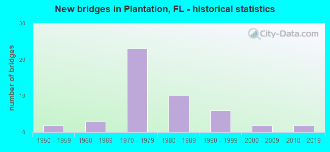
- New bridges - historical statistics
- 21950-1959
- 31960-1969
- 231970-1979
- 101980-1989
- 61990-1999
- 22000-2009
- 22010-2019
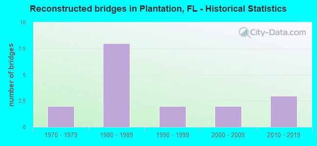
- Reconstructed bridges - Historical Statistics
- 21970-1979
- 81980-1989
- 21990-1999
- 22000-2009
- 32010-2019
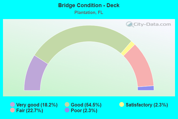
- Bridge Condition - Deck
- 18.2%Very good
- 54.5%Good
- 2.3%Satisfactory
- 22.7%Fair
- 2.3%Poor
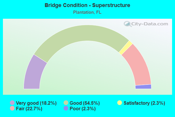
- Bridge Condition - Superstructure
- 18.2%Very good
- 54.5%Good
- 2.3%Satisfactory
- 22.7%Fair
- 2.3%Poor
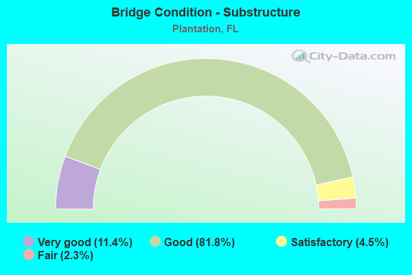
- Bridge Condition - Substructure
- 11.4%Very good
- 81.8%Good
- 4.5%Satisfactory
- 2.3%Fair
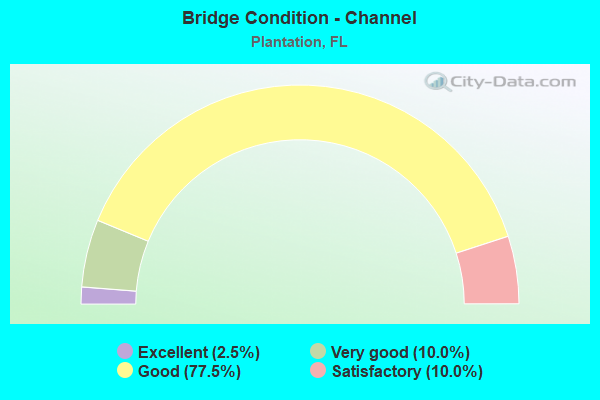
- Bridge Condition - Channel
- 2.5%Excellent
- 10.0%Very good
- 77.5%Good
- 10.0%Satisfactory
Find on map >> Show street view
Structure Number: 860014, Location: 200ft. S/O SR-838 (Lat: 26.135450, Lng: -80.202464), Route carried "on" structure: US 441, Year Built: 1963, Year Reconstructed: 1999, Status: Open, Structure Length: 2.36m (7.74ft), Average Daily Traffic: 45,000 (year 2020), Truck Traffic: 4%, Average Future Daily Traffic: 78,075 (year 2042), Design Load: HS 20+Mod, Features Intersected: C-12 Canal
Minimum Vertical Clearance: 30+ m (98+ ft), Kilometerpoint: 18.141, Lanes on structure: 9, Base Highway Network: Yes, Owner: State Highway Agency, Approaching Roadway Width: 30.2m (99.1ft), Skew: 20 degrees, Material/Design: Prestressed concrete, Design/Construction: Slab, Number Of Spans In Main Unit: 3, Length of Maximum Span: 7.9m (25.9ft), Curb or Sidewalk Widths: Left: 3.5m (11.5ft), Right: 1.8m (5.9ft), Curb-To-Curb Width: 49.4m (162.1ft), Out-to-Out Width: 50.5m (165.7ft)
Condition: Deck: Fair, Superstructure: Fair, Substructure: Good, Channel: Good, Operating Rating: 33.6 metric tons, Method Used To Determine Operating Rating: Load and Resistance Factor (LRFR), Inventory Rating: 26.6 metric tons, Method Used To Determine Inventory Rating: Load and Resistance Factor (LRFR), Structural Evaluation: Somewhat better than minimum adequacy, Deck Geometry: Superior to present desirable criteria, Waterway Adequacy: Superior to present desirable criteria, Approach Roadway Alignment: Equal to present desirable criteria, Designated Inspection Frequency: Every 24 months, Underwater Inspection Frequency: Every 24 months, Inspection Date: Febuary 2022, Underwater Inspection Date: Febuary 2022, Deck Structure Type: Concrete Precast Panels
Find on map >> Show street view
Structure Number: 860094, Location: 1 mi. E. of SR-817 (Lat: 26.120875, Lng: -80.234225), Route carried "on" structure: State highway 842, Year Built: 1972, Status: Open, Structure Length: 2.00m (6.56ft), Average Daily Traffic: 42,500 (year 2020), Truck Traffic: 3%, Average Future Daily Traffic: 73,738 (year 2042), Design Load: HS 20+Mod, Features Intersected: Holloway Canal, Facility Carried by Structure: Broward Blvd.
Minimum Vertical Clearance: 30+ m (98+ ft), Kilometerpoint: 1.817, Lanes on structure: 6, Base Highway Network: Yes, Owner: State Highway Agency, Approaching Roadway Width: 26.8m (87.9ft), Skew: 20 degrees, Material/Design: Prestressed concrete, Design/Construction: Slab, Number Of Spans In Main Unit: 2, Length of Maximum Span: 10.0m (32.8ft), Curb or Sidewalk Widths: Left: 1.4m (4.6ft), Right: 1.4m (4.6ft), Curb-To-Curb Width: 27.1m (88.9ft), Out-to-Out Width: 30.6m (100.4ft)
Condition: Deck: Fair, Superstructure: Fair, Substructure: Good, Channel: Satisfactory, Operating Rating: 62.1 metric tons, Method Used To Determine Operating Rating: Load Factor (LF), Inventory Rating: 32.7 metric tons, Method Used To Determine Inventory Rating: Load Factor (LF), Structural Evaluation: Somewhat better than minimum adequacy, Deck Geometry: Better than present minimum criteria, Waterway Adequacy: Superior to present desirable criteria, Approach Roadway Alignment: Equal to present desirable criteria, Designated Inspection Frequency: Every 24 months, Underwater Inspection Frequency: Every 24 months, Inspection Date: Febuary 2022, Underwater Inspection Date: Febuary 2022, Deck Structure Type: Concrete Precast Panels, Wearing Surface/Protective System: Wearing Surface: Bituminous
Find on map >> Show street view
Structure Number: 860158, Location: N. of I-595 on SR-817 (Lat: 26.099636, Lng: -80.250217), Route carried "on" structure: State highway 817, Year Built: 1963, Year Reconstructed: 1980, Status: Open, Structure Length: 4.57m (14.99ft), Average Daily Traffic: 69,000 (year 2020), Truck Traffic: 3%, Average Future Daily Traffic: 119,715 (year 2042), Design Load: HS 20+Mod, Features Intersected: North New River Canal, Facility Carried by Structure: University Dr.
Minimum Vertical Clearance: 6.49m (21.29ft), Kilometerpoint: 14.257, Lanes on structure: 7, Base Highway Network: Yes, Owner: State Highway Agency, Approaching Roadway Width: 26.8m (87.9ft), Skew: 20 degrees, Material/Design: Prestressed concrete, Design/Construction: Slab, Number Of Spans In Main Unit: 5, Length of Maximum Span: 10.1m (33.1ft), Curb or Sidewalk Widths: Left: 1.5m (4.9ft), Right: 1.5m (4.9ft), Curb-To-Curb Width: 33.7m (110.6ft), Out-to-Out Width: 38.1m (125.0ft)
Condition: Deck: Fair, Superstructure: Fair, Substructure: Good, Channel: Good, Operating Rating: 38.8 metric tons, Method Used To Determine Operating Rating: Load and Resistance Factor (LRFR), Inventory Rating: 33.0 metric tons, Method Used To Determine Inventory Rating: Load and Resistance Factor (LRFR), Structural Evaluation: Somewhat better than minimum adequacy, Deck Geometry: Superior to present desirable criteria, Waterway Adequacy: Superior to present desirable criteria, Approach Roadway Alignment: Equal to present desirable criteria, Designated Inspection Frequency: Every 24 months, Underwater Inspection Frequency: Every 24 months, Inspection Date: April 2020, Underwater Inspection Date: April 2020, Deck Structure Type: Concrete Precast Panels, Wearing Surface/Protective System: Wearing Surface: Bituminous
Find on map >> Show street view
Structure Number: 860185, Location: 1.1mi N of Broward Blvd. (Lat: 26.135683, Lng: -80.256956), Route carried "on" structure: State highway 817, Year Built: 1972, Year Reconstructed: 1981, Status: Open, Structure Length: 1.83m (6.00ft), Average Daily Traffic: 28,750 (year 2021), Truck Traffic: 2%, Average Future Daily Traffic: 49,881 (year 2042), Design Load: HS 20, Features Intersected: Plantation Canal C-12, Facility Carried by Structure: SB University Dr.
Minimum Vertical Clearance: 30+ m (98+ ft), Kilometerpoint: 18.395, Lanes on structure: 3, Base Highway Network: Yes, Owner: State Highway Agency, Approaching Roadway Width: 13.0m (42.7ft), Material/Design: Prestressed concrete, Design/Construction: Slab, Number Of Spans In Main Unit: 2, Length of Maximum Span: 9.1m (29.9ft), Curb or Sidewalk Widths: Left: 1.5m (4.9ft), Right: 0.0m, Curb-To-Curb Width: 13.0m (42.7ft), Out-to-Out Width: 18.6m (61.0ft)
Condition: Deck: Fair, Superstructure: Fair, Substructure: Very good, Channel: Good, Operating Rating: 80.1 metric tons, Method Used To Determine Operating Rating: Load Factor (LF), Inventory Rating: 48.1 metric tons, Method Used To Determine Inventory Rating: Load Factor (LF), Structural Evaluation: Somewhat better than minimum adequacy, Deck Geometry: Meets minimum limits, Waterway Adequacy: Superior to present desirable criteria, Approach Roadway Alignment: Equal to present desirable criteria, Designated Inspection Frequency: Every 24 months, Underwater Inspection Frequency: Every 24 months, Inspection Date: April 2021, Underwater Inspection Date: April 2021, Deck Structure Type: Concrete Precast Panels, Wearing Surface/Protective System: Wearing Surface: Bituminous
Find on map >> Show street view
Structure Number: 860227, Location: 1.1mi N of Broward Blvd (Lat: 26.135569, Lng: -80.256633), Route carried "on" structure: State highway 817, Year Built: 1969, Year Reconstructed: 1981, Status: Open, Structure Length: 1.04m (3.41ft), Average Daily Traffic: 54,500 (year 2021), Truck Traffic: 3%, Average Future Daily Traffic: 94,558 (year 2042), Design Load: HS 20, Features Intersected: Plantation Canal C-12, Facility Carried by Structure: NB University Dr.
Minimum Vertical Clearance: 30+ m (98+ ft), Kilometerpoint: 18.398, Lanes on structure: 3, Base Highway Network: Yes, Owner: State Highway Agency, Approaching Roadway Width: 13.0m (42.7ft), Material/Design: Prestressed concrete, Design/Construction: Slab, Number Of Spans In Main Unit: 1, Length of Maximum Span: 10.4m (34.1ft), Curb or Sidewalk Widths: Left: 0.0m, Right: 1.5m (4.9ft), Curb-To-Curb Width: 13.0m (42.7ft), Out-to-Out Width: 15.5m (50.9ft)
Condition: Deck: Fair, Superstructure: Fair, Substructure: Good, Channel: Good, Operating Rating: 59.0 metric tons, Method Used To Determine Operating Rating: Load Factor (LF), Inventory Rating: 35.4 metric tons, Method Used To Determine Inventory Rating: Load Factor (LF), Structural Evaluation: Somewhat better than minimum adequacy, Deck Geometry: Meets minimum limits, Waterway Adequacy: Superior to present desirable criteria, Approach Roadway Alignment: Equal to present desirable criteria, Designated Inspection Frequency: Every 24 months, Underwater Inspection Frequency: Every 24 months, Inspection Date: April 2021, Underwater Inspection Date: April 2021, Deck Structure Type: Concrete Precast Panels, Wearing Surface/Protective System: Wearing Surface: Bituminous
Find on map >> Show street view
Structure Number: 860356, Location: NOB HILL RD JCT W/SR-84 (Lat: 26.107683, Lng: -80.282025), Route carried "on" structure: County highway , Year Built: 1988, Year Reconstructed: 2012, Status: Open, Structure Length: 4.61m (15.12ft), Average Daily Traffic: 29,322 (year 2021), Truck Traffic: 5%, Average Future Daily Traffic: 35,186 (year 2042), Design Load: HS 20, Features Intersected: N. NEW RIVER CANAL, Facility Carried by Structure: NOB HILL RD.
Minimum Vertical Clearance: 30+ m (98+ ft), Kilometerpoint: 15.258, Lanes on structure: 7, Owner: County Highway Agency, Approaching Roadway Width: 30.4m (99.7ft), Skew: 21 degrees, Material/Design: Concrete continuous, Design/Construction: Slab, Number Of Spans In Main Unit: 5, Length of Maximum Span: 9.2m (30.2ft), Curb or Sidewalk Widths: Left: 2.2m (7.2ft), Right: 2.2m (7.2ft), Curb-To-Curb Width: 30.4m (99.7ft), Out-to-Out Width: 40.2m (131.9ft)
Condition: Deck: Good, Superstructure: Good, Substructure: Good, Channel: Good, Operating Rating: 67.2 metric tons, Method Used To Determine Operating Rating: Load Factor (LF), Inventory Rating: 40.3 metric tons, Method Used To Determine Inventory Rating: Load Factor (LF), Structural Evaluation: Better than present minimum criteria, Deck Geometry: Equal to present minimum criteria, Waterway Adequacy: Equal to present desirable criteria, Approach Roadway Alignment: Equal to present desirable criteria, Designated Inspection Frequency: Every 24 months, Underwater Inspection Frequency: Every 24 months, Inspection Date: Febuary 2021, Underwater Inspection Date: March 2021, Deck Structure Type: Concrete Cast-file-Place
Find on map >> Show street view
Structure Number: 860374, Location: 1 M S OF SR-838 SUNRISE B (Lat: 26.120931, Lng: -80.218231), Route carried "on" structure: State highway 91, Year Built: 1983, Year Reconstructed: 2009, Status: Open, Structure Length: 6.25m (20.51ft), Average Daily Traffic: 64,350 (year 2021), Truck Traffic: 13%, Average Future Daily Traffic: 111,647 (year 2042), Design Load: H 20, Features Intersected: SR 842 W BROWARD BLVD
Minimum Vertical Clearance: 30+ m (98+ ft), Kilometerpoint: 16.921, Lanes on structure: 5, Lanes under structure: 6, Base Highway Network: Yes, Toll: On toll road, Owner: State Toll Authority, Approaching Roadway Width: 25.3m (83.0ft), Skew: 1 degrees, Material/Design: Prestressed concrete, Design/Construction: Stringer/Multi-beam, Number Of Spans In Main Unit: 4, Length of Maximum Span: 20.7m (67.9ft), Curb-To-Curb Width: 26.1m (85.6ft), Out-to-Out Width: 26.1m (85.6ft)
Condition: Deck: Good, Superstructure: Very good, Substructure: Good, Operating Rating: 53.1 metric tons, Method Used To Determine Operating Rating: Load Factor (LF), Inventory Rating: 33.0 metric tons, Method Used To Determine Inventory Rating: Load Factor (LF), Structural Evaluation: Better than present minimum criteria, Deck Geometry: Superior to present desirable criteria, Underclear: High priority of corrective action, Approach Roadway Alignment: Equal to present desirable criteria, Length Of Structure Improvement: 6.25m (20.51ft), Designated Inspection Frequency: Every 24 months, Inspection Date: September 2021, Bridge Improvement Cost: $42,000, Total Project Cost: $42,000, Deck Structure Type: Concrete Cast-file-Place
Find on map >> Show street view
Structure Number: 860375, Location: 1 MI S OF SUNRISE BLVD (Lat: 26.120933, Lng: -80.217994), Route carried "on" structure: State highway 91, Year Built: 1983, Year Reconstructed: 2010, Status: Open, Structure Length: 6.25m (20.51ft), Average Daily Traffic: 64,350 (year 2021), Truck Traffic: 13%, Average Future Daily Traffic: 111,647 (year 2042), Design Load: HL 93, Features Intersected: SR 842 W BROWARD BLVD
Minimum Vertical Clearance: 30+ m (98+ ft), Kilometerpoint: 16.945, Lanes on structure: 5, Lanes under structure: 6, Base Highway Network: Yes, Toll: On toll road, Owner: State Toll Authority, Approaching Roadway Width: 24.6m (80.7ft), Skew: 1 degrees, Material/Design: Prestressed concrete, Design/Construction: Stringer/Multi-beam, Number Of Spans In Main Unit: 4, Length of Maximum Span: 20.7m (67.9ft), Curb-To-Curb Width: 24.6m (80.7ft), Out-to-Out Width: 25.5m (83.7ft)
Condition: Deck: Good, Superstructure: Very good, Substructure: Good, Operating Rating: 34.9 metric tons, Method Used To Determine Operating Rating: Load and Resistance Factor (LRFR), Inventory Rating: 32.7 metric tons, Method Used To Determine Inventory Rating: Load and Resistance Factor (LRFR), Structural Evaluation: Better than present minimum criteria, Deck Geometry: Better than present minimum criteria, Underclear: High priority of corrective action, Approach Roadway Alignment: Equal to present desirable criteria, Length Of Structure Improvement: 6.25m (20.51ft), Designated Inspection Frequency: Every 24 months, Inspection Date: September 2021, Bridge Improvement Cost: $36,000, Total Project Cost: $36,000, Deck Structure Type: Concrete Cast-file-Place
Find on map >> Show street view
Structure Number: 860376, Location: 1.0 MI N OF SR-842 (Lat: 26.135633, Lng: -80.219142), Route carried "on" structure: State highway 91, Year Built: 1983, Year Reconstructed: 2019, Status: Open, Structure Length: 2.62m (8.60ft), Average Daily Traffic: 64,350 (year 2021), Truck Traffic: 13%, Average Future Daily Traffic: 111,647 (year 2042), Design Load: HL 93, Features Intersected: PLANTATION CANAL C-12
Minimum Vertical Clearance: 4.66m (15.29ft), Kilometerpoint: 18.606, Lanes on structure: 5, Base Highway Network: Yes, Toll: On toll road, Owner: State Toll Authority, Approaching Roadway Width: 26.1m (85.6ft), Material/Design: Prestressed concrete, Design/Construction: Slab, Number Of Spans In Main Unit: 3, Length of Maximum Span: 9.1m (29.9ft), Curb-To-Curb Width: 26.1m (85.6ft), Out-to-Out Width: 26.7m (87.6ft)
Condition: Deck: Very good, Superstructure: Very good, Substructure: Good, Channel: Good, Operating Rating: 50.3 metric tons, Method Used To Determine Operating Rating: Load and Resistance Factor (LRFR), Inventory Rating: 38.8 metric tons, Method Used To Determine Inventory Rating: Load and Resistance Factor (LRFR), Structural Evaluation: Better than present minimum criteria, Deck Geometry: Meets minimum limits, Waterway Adequacy: Superior to present desirable criteria, Approach Roadway Alignment: Equal to present desirable criteria, Designated Inspection Frequency: Every 24 months, Underwater Inspection Frequency: Every 24 months, Inspection Date: September 2021, Underwater Inspection Date: September 2021, Deck Structure Type: Concrete Precast Panels, Wearing Surface/Protective System: Wearing Surface: Bituminous
Find on map >> Show street view
Structure Number: 860377, Location: 1.0 MI N OF SR-842 (Lat: 26.135611, Lng: -80.218961), Route carried "on" structure: State highway 91, Year Built: 1983, Year Reconstructed: 2019, Status: Open, Structure Length: 2.62m (8.60ft), Average Daily Traffic: 64,350 (year 2021), Truck Traffic: 13%, Average Future Daily Traffic: 111,647 (year 2042), Design Load: HL 93, Features Intersected: PLANTATION CANAL C-12
Minimum Vertical Clearance: 5.39m (17.68ft), Kilometerpoint: 18.606, Lanes on structure: 5, Base Highway Network: Yes, Toll: On toll road, Owner: State Toll Authority, Approaching Roadway Width: 25.8m (84.6ft), Material/Design: Prestressed concrete, Design/Construction: Slab, Number Of Spans In Main Unit: 3, Length of Maximum Span: 9.1m (29.9ft), Curb-To-Curb Width: 25.8m (84.6ft), Out-to-Out Width: 26.6m (87.3ft)
Condition: Deck: Very good, Superstructure: Very good, Substructure: Good, Channel: Good, Operating Rating: 50.3 metric tons, Method Used To Determine Operating Rating: Load and Resistance Factor (LRFR), Inventory Rating: 38.8 metric tons, Method Used To Determine Inventory Rating: Load and Resistance Factor (LRFR), Structural Evaluation: Better than present minimum criteria, Deck Geometry: Equal to present desirable criteria, Waterway Adequacy: Superior to present desirable criteria, Approach Roadway Alignment: Equal to present desirable criteria, Designated Inspection Frequency: Every 24 months, Underwater Inspection Frequency: Every 24 months, Inspection Date: September 2021, Underwater Inspection Date: September 2021, Deck Structure Type: Concrete Precast Panels, Wearing Surface/Protective System: Wearing Surface: Bituminous
Find on map >> Show street view
Structure Number: 860412, Location: 0.36mi E of University Dr (Lat: 26.148739, Lng: -80.251044), Route carried "on" structure: State highway 838, Year Built: 1978, Status: Open, Structure Length: 1.22m (4.00ft), Average Daily Traffic: 35,000 (year 2020), Truck Traffic: 5%, Average Future Daily Traffic: 60,725 (year 2042), Design Load: HS 20, Features Intersected: A-1 Canal
Minimum Vertical Clearance: 30+ m (98+ ft), Kilometerpoint: 0.594, Lanes on structure: 6, Base Highway Network: Yes, Owner: State Highway Agency, Approaching Roadway Width: 26.8m (87.9ft), Skew: 20 degrees, Material/Design: Prestressed concrete, Design/Construction: Slab, Number Of Spans In Main Unit: 1, Length of Maximum Span: 12.2m (40.0ft), Curb or Sidewalk Widths: Left: 1.5m (4.9ft), Right: 1.5m (4.9ft), Curb-To-Curb Width: 29.6m (97.1ft), Out-to-Out Width: 33.5m (109.9ft)
Condition: Deck: Good, Superstructure: Good, Substructure: Good, Channel: Good, Operating Rating: 52.3 metric tons, Method Used To Determine Operating Rating: Load Testing, Inventory Rating: 31.0 metric tons, Method Used To Determine Inventory Rating: Load Testing, Structural Evaluation: Better than present minimum criteria, Deck Geometry: Superior to present desirable criteria, Waterway Adequacy: Superior to present desirable criteria, Approach Roadway Alignment: Equal to present desirable criteria, Designated Inspection Frequency: Every 24 months, Underwater Inspection Frequency: Every 24 months, Inspection Date: March 2020, Underwater Inspection Date: March 2020, Deck Structure Type: Concrete Precast Panels, Wearing Surface/Protective System: Wearing Surface: Bituminous
Find on map >> Show street view
Structure Number: 860624, Location: 1mi. east of SR-91 (Lat: 26.136131, Lng: -80.202475), Route carried "on" structure: State highway 838, Year Built: 1999, Status: Open, Structure Length: 15.50m (50.85ft), Average Daily Traffic: 26,750 (year 2022), Truck Traffic: 5%, Average Future Daily Traffic: 46,411 (year 2042), Design Load: HS 20+Mod, Features Intersected: US-441 (SR-7), Facility Carried by Structure: WB Sunrise Blvd.
Minimum Vertical Clearance: 30+ m (98+ ft), Kilometerpoint: 6.405, Lanes on structure: 3, Lanes under structure: 8, Base Highway Network: Yes, Owner: State Highway Agency, Approaching Roadway Width: 14.6m (47.9ft), Material/Design: Steel continuous, Design/Construction: Stringer/Multi-beam, Number Of Spans In Main Unit: 3, Length of Maximum Span: 79.0m (259.2ft), Curb-To-Curb Width: 14.6m (47.9ft), Out-to-Out Width: 15.6m (51.2ft)
Condition: Deck: Very good, Superstructure: Good, Substructure: Good, Operating Rating: 67.8 metric tons, Method Used To Determine Operating Rating: Load Factor (LF), Inventory Rating: 40.6 metric tons, Method Used To Determine Inventory Rating: Load Factor (LF), Structural Evaluation: Better than present minimum criteria, Deck Geometry: Somewhat better than minimum adequacy, Underclear: Superior to present desirable criteria, Approach Roadway Alignment: Equal to present desirable criteria, Designated Inspection Frequency: Every 24 months, Inspection Date: January 2022, Deck Structure Type: Concrete Cast-file-Place
Find on map >> Show street view
Structure Number: 860625, Location: 1mi. east of SR-91 (Lat: 26.135964, Lng: -80.202458), Route carried "on" structure: State highway 838, Year Built: 1999, Status: Open, Structure Length: 15.50m (50.85ft), Average Daily Traffic: 26,750 (year 2022), Truck Traffic: 5%, Average Future Daily Traffic: 46,411 (year 2042), Design Load: HS 20+Mod, Features Intersected: US-441 (SR-7), Facility Carried by Structure: EB Sunrise Blvd.
Minimum Vertical Clearance: 30+ m (98+ ft), Kilometerpoint: 6.405, Lanes on structure: 3, Lanes under structure: 10, Base Highway Network: Yes, Owner: State Highway Agency, Approaching Roadway Width: 14.6m (47.9ft), Material/Design: Steel continuous, Design/Construction: Stringer/Multi-beam, Number Of Spans In Main Unit: 3, Length of Maximum Span: 79.0m (259.2ft), Curb-To-Curb Width: 14.6m (47.9ft), Out-to-Out Width: 15.6m (51.2ft)
Condition: Deck: Very good, Superstructure: Good, Substructure: Very good, Operating Rating: 67.8 metric tons, Method Used To Determine Operating Rating: Load Factor (LF), Inventory Rating: 40.6 metric tons, Method Used To Determine Inventory Rating: Load Factor (LF), Structural Evaluation: Better than present minimum criteria, Deck Geometry: Somewhat better than minimum adequacy, Underclear: Superior to present desirable criteria, Approach Roadway Alignment: Equal to present desirable criteria, Designated Inspection Frequency: Every 24 months, Inspection Date: January 2022, Deck Structure Type: Concrete Cast-file-Place
Find on map >> Show street view
Structure Number: 861015, Location: 1.0 Mile N of SR-842 (Lat: 26.135556, Lng: -80.218422), Route carried "on" structure: Ramp State highway 91, Year Built: 2018, Status: Open, Structure Length: 7.45m (24.44ft), Average Daily Traffic: 12,100 (year 2021), Truck Traffic: 13%, Average Future Daily Traffic: 20,994 (year 2042), Design Load: HL 93, Features Intersected: C-12 Canal
Minimum Vertical Clearance: 30.45m (99.90ft), Kilometerpoint: 0.311, Lanes on structure: 1, Base Highway Network: Yes, Toll: On toll road, Owner: State Toll Authority, Approaching Roadway Width: 10.4m (34.1ft), Skew: 4 degrees, Material/Design: Concrete continuous, Design/Construction: Stringer/Multi-beam, Number Of Spans In Main Unit: 3, Length of Maximum Span: 24.9m (81.7ft), Curb-To-Curb Width: 10.4m (34.1ft), Out-to-Out Width: 11.3m (37.1ft)
Condition: Deck: Very good, Superstructure: Very good, Substructure: Very good, Channel: Very good, Operating Rating: 46.1 metric tons, Method Used To Determine Operating Rating: Load and Resistance Factor (LRFR), Inventory Rating: 35.6 metric tons, Method Used To Determine Inventory Rating: Load and Resistance Factor (LRFR), Structural Evaluation: Equal to present desirable criteria, Deck Geometry: Superior to present desirable criteria, Waterway Adequacy: Superior to present desirable criteria, Approach Roadway Alignment: Equal to present desirable criteria, Designated Inspection Frequency: Every 24 months, Underwater Inspection Frequency: Every 24 months, Inspection Date: September 2021, Underwater Inspection Date: September 2021, Deck Structure Type: Concrete Cast-file-Place
Find on map >> Show street view
Structure Number: 861016, Location: 1.0 Mi N OF SR-842 (Lat: 26.135608, Lng: -80.219661), Route carried "on" structure: Ramp State highway 91, Year Built: 2018, Status: Open, Structure Length: 5.25m (17.22ft), Average Daily Traffic: 12,100 (year 2021), Truck Traffic: 13%, Average Future Daily Traffic: 20,994 (year 2042), Design Load: HL 93, Features Intersected: C-12 CANAL
Minimum Vertical Clearance: 30.45m (99.90ft), Kilometerpoint: 0.000, Lanes on structure: 1, Base Highway Network: Yes, Toll: On toll road, Owner: State Toll Authority, Approaching Roadway Width: 10.4m (34.1ft), Skew: 5 degrees, Material/Design: Concrete continuous, Design/Construction: Stringer/Multi-beam, Number Of Spans In Main Unit: 3, Length of Maximum Span: 21.3m (69.9ft), Curb-To-Curb Width: 10.4m (34.1ft), Out-to-Out Width: 11.3m (37.1ft)
Condition: Deck: Very good, Superstructure: Very good, Substructure: Very good, Channel: Excellent, Operating Rating: 55.2 metric tons, Method Used To Determine Operating Rating: Load and Resistance Factor (LRFR), Inventory Rating: 42.5 metric tons, Method Used To Determine Inventory Rating: Load and Resistance Factor (LRFR), Structural Evaluation: Equal to present desirable criteria, Deck Geometry: Superior to present desirable criteria, Waterway Adequacy: Superior to present desirable criteria, Approach Roadway Alignment: Equal to present desirable criteria, Designated Inspection Frequency: Every 24 months, Underwater Inspection Frequency: Every 24 months, Inspection Date: September 2021, Underwater Inspection Date: September 2021, Deck Structure Type: Concrete Cast-file-Place
Find on map >> Show street view
Structure Number: 864037, Location: 1.0MI E OF UNIVERSITY DR (Lat: 26.105772, Lng: -80.233683), Route carried "on" structure: County highway , Year Built: 1980, Status: Open, Structure Length: 2.44m (8.01ft), Average Daily Traffic: 24,440 (year 2021), Truck Traffic: 5%, Average Future Daily Traffic: 40,772 (year 2042), Design Load: HS 20, Features Intersected: HOLLOWAY CANAL, Facility Carried by Structure: PETERS ROAD
Minimum Vertical Clearance: 30+ m (98+ ft), Kilometerpoint: 1.630, Lanes on structure: 4, Owner: County Highway Agency, Approaching Roadway Width: 21.8m (71.5ft), Skew: 20 degrees, Material/Design: Prestressed concrete, Design/Construction: Slab, Number Of Spans In Main Unit: 2, Length of Maximum Span: 12.2m (40.0ft), Curb or Sidewalk Widths: Left: 1.8m (5.9ft), Right: 1.7m (5.6ft), Curb-To-Curb Width: 21.8m (71.5ft), Out-to-Out Width: 30.3m (99.4ft)
Condition: Deck: Good, Superstructure: Good, Substructure: Good, Channel: Good, Operating Rating: 57.0 metric tons, Method Used To Determine Operating Rating: Allowable Stress (AS), Inventory Rating: 32.9 metric tons, Method Used To Determine Inventory Rating: Allowable Stress (AS), Structural Evaluation: Better than present minimum criteria, Deck Geometry: Superior to present desirable criteria, Waterway Adequacy: Equal to present desirable criteria, Approach Roadway Alignment: Equal to present desirable criteria, Designated Inspection Frequency: Every 24 months, Underwater Inspection Frequency: Every 24 months, Inspection Date: April 2021, Underwater Inspection Date: April 2021, Deck Structure Type: Concrete Precast Panels, Wearing Surface/Protective System: Wearing Surface: Bituminous
Find on map >> Show street view
Structure Number: 864038, Location: 0.1MI E OF PINE ISLAND RD (Lat: 26.146769, Lng: -80.267147), Route carried "on" structure: County highway 838, Year Built: 1978, Year Reconstructed: 1980, Status: Open, Structure Length: 2.16m (7.09ft), Average Daily Traffic: 10,000 (year 2021), Truck Traffic: 2%, Average Future Daily Traffic: 13,880 (year 2042), Features Intersected: C-2 CANAL
Minimum Vertical Clearance: 30+ m (98+ ft), Kilometerpoint: 0.124, Lanes on structure: 6, Base Highway Network: Yes, Owner: County Highway Agency, Approaching Roadway Width: 24.4m (80.1ft), Skew: 20 degrees, Material/Design: Concrete, Design/Construction: Slab, Number Of Spans In Main Unit: 3, Length of Maximum Span: 7.3m (24.0ft), Curb or Sidewalk Widths: Left: 1.5m (4.9ft), Right: 1.5m (4.9ft), Curb-To-Curb Width: 24.4m (80.1ft), Out-to-Out Width: 31.8m (104.3ft)
Condition: Deck: Satisfactory, Superstructure: Satisfactory, Substructure: Good, Channel: Good, Operating Rating: 44.5 metric tons, Method Used To Determine Operating Rating: Load and Resistance Factor (LRFR), Inventory Rating: 34.4 metric tons, Method Used To Determine Inventory Rating: Load and Resistance Factor (LRFR), Structural Evaluation: Equal to present minimum criteria, Deck Geometry: Somewhat better than minimum adequacy, Waterway Adequacy: Better than present minimum criteria, Approach Roadway Alignment: Better than present minimum criteria, Designated Inspection Frequency: Every 24 months, Underwater Inspection Frequency: Every 24 months, Inspection Date: April 2021, Underwater Inspection Date: April 2021, Deck Structure Type: Concrete Cast-file-Place, Wearing Surface/Protective System: Wearing Surface: Bituminous
Find on map >> Show street view
Structure Number: 864043, Location: 0.2MI E of NOB HILL ROAD (Lat: 26.120800, Lng: -80.282467), Route carried "on" structure: County highway , Year Built: 1976, Year Reconstructed: 1996, Status: Open, Structure Length: 2.20m (7.22ft), Average Daily Traffic: 52,000 (year 2021), Truck Traffic: 2%, Average Future Daily Traffic: 62,400 (year 2042), Design Load: HS 20, Features Intersected: C-3 CANAL, Facility Carried by Structure: WEST BROWARD BLVD
Minimum Vertical Clearance: 30+ m (98+ ft), Kilometerpoint: 0.285, Lanes on structure: 6, Owner: County Highway Agency, Approaching Roadway Width: 24.7m (81.0ft), Skew: 20 degrees, Material/Design: Prestressed concrete, Design/Construction: Slab, Number Of Spans In Main Unit: 2, Length of Maximum Span: 11.0m (36.1ft), Curb or Sidewalk Widths: Left: 1.9m (6.2ft), Right: 0.0m, Curb-To-Curb Width: 24.7m (81.0ft), Out-to-Out Width: 34.1m (111.9ft)
Condition: Deck: Good, Superstructure: Good, Substructure: Very good, Channel: Good, Operating Rating: 71.8 metric tons, Method Used To Determine Operating Rating: Load Factor (LF), Inventory Rating: 43.1 metric tons, Method Used To Determine Inventory Rating: Load Factor (LF), Structural Evaluation: Better than present minimum criteria, Deck Geometry: Somewhat better than minimum adequacy, Waterway Adequacy: Better than present minimum criteria, Approach Roadway Alignment: Equal to present desirable criteria, Designated Inspection Frequency: Every 24 months, Underwater Inspection Frequency: Every 24 months, Inspection Date: March 2021, Underwater Inspection Date: March 2021, Deck Structure Type: Concrete Precast Panels, Wearing Surface/Protective System: Wearing Surface: Bituminous
Find on map >> Show street view
Structure Number: 864053, Location: 0.8MI N OF W BROWARD BLVD (Lat: 26.132508, Lng: -80.266822), Route carried "on" structure: County highway , Year Built: 1975, Year Reconstructed: 1992, Status: Open, Structure Length: 2.83m (9.28ft), Average Daily Traffic: 30,000 (year 2021), Truck Traffic: 2%, Average Future Daily Traffic: 43,375 (year 2042), Features Intersected: C-2 CANAL, Facility Carried by Structure: PINE ISLAND RD SB
Minimum Vertical Clearance: 30+ m (98+ ft), Kilometerpoint: 1.485, Lanes on structure: 3, Owner: County Highway Agency, Approaching Roadway Width: 11.9m (39.0ft), Skew: 4 degrees, Material/Design: Concrete, Design/Construction: Slab, Number Of Spans In Main Unit: 3, Length of Maximum Span: 9.4m (30.8ft), Curb or Sidewalk Widths: Left: 1.5m (4.9ft), Right: 0.0m, Curb-To-Curb Width: 11.9m (39.0ft), Out-to-Out Width: 15.2m (49.9ft)
Condition: Deck: Good, Superstructure: Good, Substructure: Good, Channel: Good, Operating Rating: 44.5 metric tons, Method Used To Determine Operating Rating: Load and Resistance Factor (LRFR), Inventory Rating: 34.3 metric tons, Method Used To Determine Inventory Rating: Load and Resistance Factor (LRFR), Structural Evaluation: Better than present minimum criteria, Deck Geometry: High priority of corrective action, Waterway Adequacy: Better than present minimum criteria, Approach Roadway Alignment: Equal to present desirable criteria, Designated Inspection Frequency: Every 24 months, Underwater Inspection Frequency: Every 24 months, Inspection Date: March 2021, Underwater Inspection Date: March 2021, Deck Structure Type: Concrete Cast-file-Place, Wearing Surface/Protective System: Wearing Surface: Bituminous
Find on map >> Show street view
Structure Number: 864054, Location: 0.8MI N OF W BROWARD BVD (Lat: 26.132711, Lng: -80.266831), Route carried "on" structure: County highway , Year Built: 1975, Year Reconstructed: 1992, Status: Open, Structure Length: 2.83m (9.28ft), Average Daily Traffic: 30,000 (year 2021), Truck Traffic: 2%, Average Future Daily Traffic: 43,375 (year 2042), Features Intersected: C-2 CANAL, Facility Carried by Structure: PINE ISLAND RD NB
Minimum Vertical Clearance: 30+ m (98+ ft), Kilometerpoint: 1.485, Lanes on structure: 3, Owner: County Highway Agency, Approaching Roadway Width: 15.4m (50.5ft), Skew: 4 degrees, Material/Design: Concrete, Design/Construction: Slab, Number Of Spans In Main Unit: 3, Length of Maximum Span: 9.4m (30.8ft), Curb or Sidewalk Widths: Left: 0.0m, Right: 1.5m (4.9ft), Curb-To-Curb Width: 15.4m (50.5ft), Out-to-Out Width: 16.9m (55.4ft)
Condition: Deck: Good, Superstructure: Good, Substructure: Good, Channel: Good, Operating Rating: 44.5 metric tons, Method Used To Determine Operating Rating: Load and Resistance Factor (LRFR), Inventory Rating: 34.3 metric tons, Method Used To Determine Inventory Rating: Load and Resistance Factor (LRFR), Structural Evaluation: Better than present minimum criteria, Deck Geometry: Equal to present minimum criteria, Waterway Adequacy: Better than present minimum criteria, Approach Roadway Alignment: Equal to present desirable criteria, Designated Inspection Frequency: Every 24 months, Underwater Inspection Frequency: Every 24 months, Inspection Date: March 2021, Underwater Inspection Date: March 2021, Deck Structure Type: Concrete Cast-file-Place, Wearing Surface/Protective System: Wearing Surface: Bituminous
Find on map >> Show street view
Structure Number: 864055, Location: 1.2MI N OF W BROWARD BLVD (Lat: 26.135586, Lng: -80.270058), Route carried "on" structure: County highway , Year Built: 1975, Year Reconstructed: 1992, Status: Open, Structure Length: 2.50m (8.20ft), Average Daily Traffic: 22,880 (year 2021), Truck Traffic: 2%, Average Future Daily Traffic: 31,230 (year 2042), Design Load: HS 20, Features Intersected: CANAL 2L-2W, Facility Carried by Structure: PINE ISLAND RD SB
Minimum Vertical Clearance: 30+ m (98+ ft), Kilometerpoint: 1.917, Lanes on structure: 3, Owner: County Highway Agency, Approaching Roadway Width: 11.4m (37.4ft), Skew: 3 degrees, Material/Design: Concrete, Design/Construction: Slab, Number Of Spans In Main Unit: 3, Length of Maximum Span: 8.4m (27.6ft), Curb or Sidewalk Widths: Left: 1.5m (4.9ft), Right: 2.3m (7.5ft), Curb-To-Curb Width: 11.4m (37.4ft), Out-to-Out Width: 15.6m (51.2ft)
Condition: Deck: Good, Superstructure: Good, Substructure: Good, Channel: Good, Operating Rating: 73.4 metric tons, Method Used To Determine Operating Rating: Load Factor (LF), Inventory Rating: 44.0 metric tons, Method Used To Determine Inventory Rating: Load Factor (LF), Structural Evaluation: Better than present minimum criteria, Deck Geometry: High priority of replacement, Waterway Adequacy: Better than present minimum criteria, Approach Roadway Alignment: Equal to present desirable criteria, Designated Inspection Frequency: Every 24 months, Underwater Inspection Frequency: Every 24 months, Inspection Date: March 2021, Underwater Inspection Date: March 2021, Deck Structure Type: Concrete Cast-file-Place, Wearing Surface/Protective System: Wearing Surface: Bituminous
Find on map >> Show street view
Structure Number: 864056, Location: 1.2MI N OF W BROWARD BLVD (Lat: 26.135583, Lng: -80.269842), Route carried "on" structure: County highway , Year Built: 1975, Year Reconstructed: 1992, Status: Open, Structure Length: 2.50m (8.20ft), Average Daily Traffic: 22,880 (year 2021), Truck Traffic: 2%, Average Future Daily Traffic: 31,230 (year 2042), Design Load: HS 20, Features Intersected: CANAL 2L-2W, Facility Carried by Structure: PINE ISLAND RD NB
Minimum Vertical Clearance: 30+ m (98+ ft), Kilometerpoint: 1.917, Lanes on structure: 3, Owner: County Highway Agency, Approaching Roadway Width: 11.9m (39.0ft), Skew: 3 degrees, Material/Design: Concrete, Design/Construction: Slab, Number Of Spans In Main Unit: 3, Length of Maximum Span: 8.4m (27.6ft), Curb or Sidewalk Widths: Left: 2.3m (7.5ft), Right: 1.5m (4.9ft), Curb-To-Curb Width: 11.9m (39.0ft), Out-to-Out Width: 16.1m (52.8ft)
Condition: Deck: Good, Superstructure: Good, Substructure: Good, Channel: Good, Operating Rating: 67.7 metric tons, Method Used To Determine Operating Rating: Allowable Stress (AS), Inventory Rating: 44.0 metric tons, Method Used To Determine Inventory Rating: Allowable Stress (AS), Structural Evaluation: Better than present minimum criteria, Deck Geometry: High priority of corrective action, Waterway Adequacy: Better than present minimum criteria, Approach Roadway Alignment: Equal to present desirable criteria, Designated Inspection Frequency: Every 24 months, Underwater Inspection Frequency: Every 24 months, Inspection Date: March 2021, Underwater Inspection Date: March 2021, Deck Structure Type: Concrete Cast-file-Place, Wearing Surface/Protective System: Wearing Surface: Bituminous
Find on map >> Show street view
Structure Number: 864057, Location: 0.2MI N. OF SUNRISE BLVD (Lat: 26.150000, Lng: -80.267961), Route carried "on" structure: County highway , Year Built: 1977, Year Reconstructed: 1992, Status: Open, Structure Length: 2.08m (6.82ft), Average Daily Traffic: 11,440 (year 2021), Truck Traffic: 5%, Average Future Daily Traffic: 13,728 (year 2042), Design Load: HS 20, Features Intersected: 2L-3W CANAL, Facility Carried by Structure: PINE ISLAND RD SB
Minimum Vertical Clearance: 30+ m (98+ ft), Kilometerpoint: 3.607, Lanes on structure: 3, Owner: County Highway Agency, Approaching Roadway Width: 12.2m (40.0ft), Material/Design: Prestressed concrete, Design/Construction: Slab, Number Of Spans In Main Unit: 2, Length of Maximum Span: 10.4m (34.1ft), Curb or Sidewalk Widths: Left: 1.5m (4.9ft), Right: 0.0m, Curb-To-Curb Width: 12.2m (40.0ft), Out-to-Out Width: 16.2m (53.1ft)
Condition: Deck: Good, Superstructure: Good, Substructure: Good, Channel: Good, Operating Rating: 88.3 metric tons, Method Used To Determine Operating Rating: Load Factor (LF), Inventory Rating: 53.0 metric tons, Method Used To Determine Inventory Rating: Load Factor (LF), Structural Evaluation: Better than present minimum criteria, Deck Geometry: Meets minimum limits, Waterway Adequacy: Better than present minimum criteria, Approach Roadway Alignment: Equal to present desirable criteria, Designated Inspection Frequency: Every 24 months, Underwater Inspection Frequency: Every 24 months, Inspection Date: April 2021, Underwater Inspection Date: April 2021, Deck Structure Type: Concrete Precast Panels, Wearing Surface/Protective System: Wearing Surface: Bituminous
Find on map >> Show street view
Structure Number: 864058, Location: 0.2MI N OF SUNRISE BLVD (Lat: 26.150000, Lng: -80.267800), Route carried "on" structure: County highway , Year Built: 1977, Year Reconstructed: 1992, Status: Open, Structure Length: 2.08m (6.82ft), Average Daily Traffic: 11,440 (year 2021), Truck Traffic: 5%, Average Future Daily Traffic: 13,728 (year 2042), Design Load: HS 20, Features Intersected: 2L-3W CANAL, Facility Carried by Structure: PINE ISLAND RD NB
Minimum Vertical Clearance: 30+ m (98+ ft), Kilometerpoint: 3.607, Lanes on structure: 3, Owner: County Highway Agency, Approaching Roadway Width: 12.2m (40.0ft), Material/Design: Prestressed concrete, Design/Construction: Slab, Number Of Spans In Main Unit: 2, Length of Maximum Span: 10.4m (34.1ft), Curb or Sidewalk Widths: Left: 0.0m, Right: 1.5m (4.9ft), Curb-To-Curb Width: 12.2m (40.0ft), Out-to-Out Width: 16.2m (53.1ft)
Condition: Deck: Good, Superstructure: Good, Substructure: Good, Channel: Good, Operating Rating: 79.5 metric tons, Method Used To Determine Operating Rating: Load Factor (LF), Inventory Rating: 47.6 metric tons, Method Used To Determine Inventory Rating: Load Factor (LF), Structural Evaluation: Better than present minimum criteria, Deck Geometry: Meets minimum limits, Waterway Adequacy: Better than present minimum criteria, Approach Roadway Alignment: Equal to present desirable criteria, Designated Inspection Frequency: Every 24 months, Underwater Inspection Frequency: Every 24 months, Inspection Date: April 2021, Underwater Inspection Date: April 2021, Deck Structure Type: Concrete Precast Panels, Wearing Surface/Protective System: Wearing Surface: Bituminous
Find on map >> Show street view
Structure Number: 864096, Location: AT NORTH SIDE OF SR-84 (Lat: 26.115331, Lng: -80.313806), Route carried "on" structure: County highway 823, Year Built: 1989, Status: Open, Structure Length: 4.19m (13.75ft), Average Daily Traffic: 12,850 (year 2021), Truck Traffic: 5%, Average Future Daily Traffic: 16,014 (year 2042), Design Load: HS 20, Features Intersected: NORTH NEW RIVER CANAL, Facility Carried by Structure: FLAMINGO ROAD SB
Minimum Vertical Clearance: 30+ m (98+ ft), Kilometerpoint: 0.008, Lanes on structure: 6, Base Highway Network: Yes, Owner: County Highway Agency, Approaching Roadway Width: 24.1m (79.1ft), Skew: 2 degrees, Material/Design: Concrete continuous, Design/Construction: Slab, Number Of Spans In Main Unit: 5, Length of Maximum Span: 10.7m (35.1ft), Curb or Sidewalk Widths: Left: 2.3m (7.5ft), Right: 0.0m, Curb-To-Curb Width: 24.1m (79.1ft), Out-to-Out Width: 27.2m (89.2ft)
Condition: Deck: Good, Superstructure: Good, Substructure: Satisfactory, Channel: Good, Operating Rating: 56.3 metric tons, Method Used To Determine Operating Rating: Load Factor (LF), Inventory Rating: 33.7 metric tons, Method Used To Determine Inventory Rating: Load Factor (LF), Structural Evaluation: Equal to present minimum criteria, Deck Geometry: Somewhat better than minimum adequacy, Waterway Adequacy: Better than present minimum criteria, Approach Roadway Alignment: Equal to present desirable criteria, Designated Inspection Frequency: Every 24 months, Underwater Inspection Frequency: Every 24 months, Inspection Date: April 2021, Underwater Inspection Date: April 2021, Deck Structure Type: Concrete Cast-file-Place
Find on map >> Show street view
Structure Number: 864097, Location: AT NORTH SIDE OF SR-84 (Lat: 26.115264, Lng: -80.313456), Route carried "on" structure: County highway 823, Year Built: 1989, Status: Open, Structure Length: 4.30m (14.11ft), Average Daily Traffic: 12,850 (year 2021), Truck Traffic: 5%, Average Future Daily Traffic: 16,014 (year 2042), Design Load: HS 20, Features Intersected: NORTH NEW RIVER CANAL, Facility Carried by Structure: FLAMINGO ROAD NB
Minimum Vertical Clearance: 30+ m (98+ ft), Kilometerpoint: 0.008, Lanes on structure: 3, Base Highway Network: Yes, Owner: County Highway Agency, Approaching Roadway Width: 12.8m (42.0ft), Skew: 2 degrees, Material/Design: Concrete continuous, Design/Construction: Slab, Number Of Spans In Main Unit: 5, Length of Maximum Span: 10.7m (35.1ft), Curb or Sidewalk Widths: Left: 0.0m, Right: 2.3m (7.5ft), Curb-To-Curb Width: 12.8m (42.0ft), Out-to-Out Width: 16.0m (52.5ft)
Condition: Deck: Good, Superstructure: Good, Substructure: Satisfactory, Channel: Satisfactory, Operating Rating: 52.2 metric tons, Method Used To Determine Operating Rating: Load Factor (LF), Inventory Rating: 31.2 metric tons, Method Used To Determine Inventory Rating: Load Factor (LF), Structural Evaluation: Equal to present minimum criteria, Deck Geometry: Meets minimum limits, Waterway Adequacy: Better than present minimum criteria, Approach Roadway Alignment: Equal to present desirable criteria, Designated Inspection Frequency: Every 24 months, Underwater Inspection Frequency: Every 24 months, Inspection Date: April 2021, Underwater Inspection Date: April 2021, Deck Structure Type: Concrete Cast-file-Place
Find on map >> Show street view
Structure Number: 864109, Location: 0.1MI W OF PINE ISLAND RD (Lat: 26.120817, Lng: -80.266394), Route carried "on" structure: County highway 842, Year Built: 1996, Status: Open, Structure Length: 2.42m (7.94ft), Average Daily Traffic: 25,282 (year 2021), Truck Traffic: 5%, Average Future Daily Traffic: 30,000 (year 2042), Design Load: HS 20, Features Intersected: C-2 CANAL, Facility Carried by Structure: W BROWARD BLVD
Minimum Vertical Clearance: 30+ m (98+ ft), Kilometerpoint: 0.436, Lanes on structure: 6, Owner: County Highway Agency, Approaching Roadway Width: 27.0m (88.6ft), Skew: 20 degrees, Material/Design: Prestressed concrete, Design/Construction: Slab, Number Of Spans In Main Unit: 2, Length of Maximum Span: 12.1m (39.7ft), Curb or Sidewalk Widths: Left: 1.8m (5.9ft), Right: 1.9m (6.2ft), Curb-To-Curb Width: 26.7m (87.6ft), Out-to-Out Width: 40.4m (132.5ft)
Condition: Deck: Good, Superstructure: Good, Substructure: Good, Channel: Very good, Operating Rating: 64.0 metric tons, Method Used To Determine Operating Rating: Load Factor (LF), Inventory Rating: 38.5 metric tons, Method Used To Determine Inventory Rating: Load Factor (LF), Structural Evaluation: Better than present minimum criteria, Deck Geometry: Equal to present minimum criteria, Waterway Adequacy: Better than present minimum criteria, Approach Roadway Alignment: Equal to present desirable criteria, Designated Inspection Frequency: Every 24 months, Underwater Inspection Frequency: Every 24 months, Inspection Date: April 2021, Underwater Inspection Date: April 2021, Deck Structure Type: Concrete Precast Panels, Wearing Surface/Protective System: Wearing Surface: Bituminous
Find on map >> Show street view
Structure Number: 868, Location: 500FT W OF SW 54TH AVE (Lat: 26.100619, Lng: -80.223128), Route carried "on" structure: City street , Year Built: 1973, Status: Open, Structure Length: 0.86m (2.82ft), Average Daily Traffic: 1,100 (year 2021), Truck Traffic: 2%, Average Future Daily Traffic: 1,700 (year 2041), Design Load: H 20, Features Intersected: 175 CANAL, Facility Carried by Structure: SW 16TH STREET
Minimum Vertical Clearance: 30+ m (98+ ft), Kilometerpoint: 0.000, Lanes on structure: 2, Owner: City or Municipal Highway Agency, Approaching Roadway Width: 6.5m (21.3ft), Material/Design: Concrete, Design/Construction: Slab, Number Of Spans In Main Unit: 1, Length of Maximum Span: 8.6m (28.2ft), Curb or Sidewalk Widths: Left: 1.0m (3.3ft), Right: 1.0m (3.3ft), Curb-To-Curb Width: 7.6m (24.9ft), Out-to-Out Width: 12.3m (40.4ft)
Condition: Deck: Poor, Superstructure: Poor, Substructure: Fair, Channel: Good, Operating Rating: 54.2 metric tons, Method Used To Determine Operating Rating: Load Factor (LF), Inventory Rating: 32.4 metric tons, Method Used To Determine Inventory Rating: Load Factor (LF), Structural Evaluation: Meets minimum limits, Deck Geometry: Meets minimum limits, Waterway Adequacy: Equal to present desirable criteria, Approach Roadway Alignment: Equal to present desirable criteria, Designated Inspection Frequency: Every 24 months, Underwater Inspection Frequency: Every 24 months, Other Special Inspection Frequency: Every 12 months, Inspection Date: June 2021, Underwater Inspection Date: June 2021, Other Special Inspection Date: January 2000, Deck Structure Type: Concrete Precast Panels, Wearing Surface/Protective System: Wearing Surface: Bituminous
Find on map >> Show street view
Structure Number: 868001, Location: 0.2MI W OF SW 54TH AVE. (Lat: 26.101442, Lng: -80.224850), Route carried "on" structure: City street , Year Built: 1976, Status: Open, Structure Length: 0.79m (2.59ft), Average Daily Traffic: 1,100 (year 2021), Truck Traffic: 2%, Average Future Daily Traffic: 1,700 (year 2041), Design Load: HS 20, Features Intersected: CANAL, Facility Carried by Structure: S.W. 16 STREET
Minimum Vertical Clearance: 30+ m (98+ ft), Kilometerpoint: 0.000, Lanes on structure: 2, Owner: City or Municipal Highway Agency, Approaching Roadway Width: 7.2m (23.6ft), Material/Design: Prestressed concrete, Design/Construction: Slab, Number Of Spans In Main Unit: 1, Length of Maximum Span: 7.9m (25.9ft), Curb or Sidewalk Widths: Left: 1.0m (3.3ft), Right: 1.0m (3.3ft), Curb-To-Curb Width: 7.6m (24.9ft), Out-to-Out Width: 12.3m (40.4ft)
Condition: Deck: Fair, Superstructure: Fair, Substructure: Good, Channel: Good, Operating Rating: 51.9 metric tons, Method Used To Determine Operating Rating: Load Factor (LF), Inventory Rating: 21.2 metric tons, Method Used To Determine Inventory Rating: Load Factor (LF), Structural Evaluation: Somewhat better than minimum adequacy, Deck Geometry: Meets minimum limits, Waterway Adequacy: Equal to present desirable criteria, Approach Roadway Alignment: Equal to present desirable criteria, Designated Inspection Frequency: Every 24 months, Underwater Inspection Frequency: Every 24 months, Inspection Date: June 2021, Underwater Inspection Date: June 2021, Deck Structure Type: Concrete Precast Panels, Wearing Surface/Protective System: Wearing Surface: Bituminous
Find on map >> Show street view
Structure Number: 868002, Location: 0.5MI W OF SW 54 AVE. (Lat: 26.102603, Lng: -80.230331), Route carried "on" structure: City street , Year Built: 1976, Status: Open, Structure Length: 0.80m (2.62ft), Average Daily Traffic: 1,100 (year 2021), Truck Traffic: 2%, Average Future Daily Traffic: 1,700 (year 2041), Design Load: HS 20, Features Intersected: NORTH NEW RIVER, Facility Carried by Structure: S.W. 16 STREET
Minimum Vertical Clearance: 30+ m (98+ ft), Kilometerpoint: 0.000, Lanes on structure: 2, Owner: City or Municipal Highway Agency, Approaching Roadway Width: 7.0m (23.0ft), Material/Design: Prestressed concrete, Design/Construction: Slab, Number Of Spans In Main Unit: 1, Length of Maximum Span: 8.0m (26.2ft), Curb or Sidewalk Widths: Left: 1.0m (3.3ft), Right: 1.0m (3.3ft), Curb-To-Curb Width: 7.7m (25.3ft), Out-to-Out Width: 12.3m (40.4ft)
Condition: Deck: Good, Superstructure: Good, Substructure: Good, Channel: Good, Operating Rating: 51.9 metric tons, Method Used To Determine Operating Rating: Load Factor (LF), Inventory Rating: 21.2 metric tons, Method Used To Determine Inventory Rating: Load Factor (LF), Structural Evaluation: Somewhat better than minimum adequacy, Deck Geometry: Meets minimum limits, Waterway Adequacy: Equal to present desirable criteria, Approach Roadway Alignment: Better than present minimum criteria, Designated Inspection Frequency: Every 24 months, Underwater Inspection Frequency: Every 24 months, Inspection Date: June 2021, Underwater Inspection Date: June 2021, Deck Structure Type: Concrete Precast Panels, Wearing Surface/Protective System: Wearing Surface: Bituminous
Find on map >> Show street view
Structure Number: 868009, Location: 250FT W OF PINE ISLAND RD (Lat: 26.112303, Lng: -80.261347), Route carried "on" structure: City street , Year Built: 1970, Status: Open, Structure Length: 2.02m (6.63ft), Average Daily Traffic: 4,320 (year 2021), Truck Traffic: 2%, Average Future Daily Traffic: 5,185 (year 2041), Design Load: HS 15, Features Intersected: CANAL, Facility Carried by Structure: GATE HOUSE ROAD
Minimum Vertical Clearance: 30+ m (98+ ft), Kilometerpoint: 0.000, Lanes on structure: 2, Owner: City or Municipal Highway Agency, Approaching Roadway Width: 8.4m (27.6ft), Skew: 1 degrees, Material/Design: Prestressed concrete, Design/Construction: Slab, Number Of Spans In Main Unit: 2, Length of Maximum Span: 10.1m (33.1ft), Curb or Sidewalk Widths: Left: 1.4m (4.6ft), Right: 1.1m (3.6ft), Curb-To-Curb Width: 8.8m (28.9ft), Out-to-Out Width: 12.2m (40.0ft)
Condition: Deck: Good, Superstructure: Good, Substructure: Good, Channel: Good, Operating Rating: 50.3 metric tons, Method Used To Determine Operating Rating: Load Factor (LF), Inventory Rating: 30.2 metric tons, Method Used To Determine Inventory Rating: Load Factor (LF), Structural Evaluation: Better than present minimum criteria, Deck Geometry: Meets minimum limits, Waterway Adequacy: Equal to present desirable criteria, Approach Roadway Alignment: Better than present minimum criteria, Designated Inspection Frequency: Every 24 months, Underwater Inspection Frequency: Every 24 months, Inspection Date: June 2021, Underwater Inspection Date: June 2021, Deck Structure Type: Concrete Precast Panels, Wearing Surface/Protective System: Wearing Surface: Bituminous
Find on map >> Show street view
Structure Number: 868014, Location: ADJ TO S SIDE OF BROWARD (Lat: 26.120572, Lng: -80.260867), Route carried "on" structure: City street , Year Built: 1978, Status: Open, Structure Length: 0.76m (2.49ft), Average Daily Traffic: 11,520 (year 2021), Truck Traffic: 5%, Average Future Daily Traffic: 13,850 (year 2042), Design Load: H 20, Features Intersected: PANAMA CANAL, Facility Carried by Structure: SW 84TH AVE
Minimum Vertical Clearance: 30+ m (98+ ft), Kilometerpoint: 0.000, Lanes on structure: 4, Owner: City or Municipal Highway Agency, Approaching Roadway Width: 17.8m (58.4ft), Skew: 20 degrees, Material/Design: Prestressed concrete, Design/Construction: Slab, Number Of Spans In Main Unit: 1, Length of Maximum Span: 7.6m (24.9ft), Curb or Sidewalk Widths: Left: 2.1m (6.9ft), Right: 2.1m (6.9ft), Curb-To-Curb Width: 17.8m (58.4ft), Out-to-Out Width: 24.3m (79.7ft)
Condition: Deck: Fair, Superstructure: Fair, Substructure: Good, Channel: Satisfactory, Operating Rating: 48.6 metric tons, Method Used To Determine Operating Rating: Load Factor (LF), Inventory Rating: 29.0 metric tons, Method Used To Determine Inventory Rating: Load Factor (LF), Structural Evaluation: Somewhat better than minimum adequacy, Deck Geometry: Somewhat better than minimum adequacy, Waterway Adequacy: Equal to present desirable criteria, Approach Roadway Alignment: Equal to present desirable criteria, Designated Inspection Frequency: Every 24 months, Underwater Inspection Frequency: Every 24 months, Inspection Date: June 2021, Underwater Inspection Date: June 2021, Deck Structure Type: Concrete Precast Panels, Wearing Surface/Protective System: Wearing Surface: Bituminous
Find on map >> Show street view
Structure Number: 868017, Location: 0.1MI E OF NOB HILL RD. (Lat: 26.112575, Lng: -80.282164), Route carried "on" structure: City street , Year Built: 1973, Status: Posted for load-capacity, Structure Length: 2.30m (7.55ft), Average Daily Traffic: 2,880 (year 2021), Truck Traffic: 2%, Average Future Daily Traffic: 3,456 (year 2041), Design Load: H 20, Features Intersected: ROSS CANAL, Facility Carried by Structure: TORCHWOOD AVENUE
Minimum Vertical Clearance: 30+ m (98+ ft), Kilometerpoint: 0.000, Lanes on structure: 2, Owner: City or Municipal Highway Agency, Approaching Roadway Width: 6.8m (22.3ft), Material/Design: Prestressed concrete, Design/Construction: Slab, Number Of Spans In Main Unit: 3, Length of Maximum Span: 7.8m (25.6ft), Curb or Sidewalk Widths: Left: 0.4m (1.3ft), Right: 1.0m (3.3ft), Curb-To-Curb Width: 8.6m (28.2ft), Out-to-Out Width: 10.5m (34.4ft)
Condition: Deck: Fair, Superstructure: Fair, Substructure: Good, Channel: Good, Operating Rating: 59.1 metric tons, Method Used To Determine Operating Rating: Load Factor (LF), Inventory Rating: 35.5 metric tons, Method Used To Determine Inventory Rating: Load Factor (LF), Structural Evaluation: Somewhat better than minimum adequacy, Deck Geometry: Meets minimum limits, Waterway Adequacy: Better than present minimum criteria, Approach Roadway Alignment: Equal to present desirable criteria, Designated Inspection Frequency: Every 24 months, Underwater Inspection Frequency: Every 24 months, Inspection Date: June 2021, Underwater Inspection Date: June 2021, Deck Structure Type: Concrete Precast Panels, Wearing Surface/Protective System: Wearing Surface: Bituminous
Find on map >> Show street view
Structure Number: 868024, Location: 100FT W OF SW 63RD AVE. (Lat: 26.102722, Lng: -80.233597), Route carried "on" structure: City street , Year Built: 1974, Status: Open, Structure Length: 2.08m (6.82ft), Average Daily Traffic: 3,120 (year 2021), Truck Traffic: 2%, Average Future Daily Traffic: 5,205 (year 2041), Design Load: HS 20, Features Intersected: HOLLOWAY CANAL, Facility Carried by Structure: S.W. 16 STREET
Minimum Vertical Clearance: 30+ m (98+ ft), Kilometerpoint: 0.000, Lanes on structure: 2, Owner: City or Municipal Highway Agency, Approaching Roadway Width: 6.7m (22.0ft), Material/Design: Prestressed concrete, Design/Construction: Slab, Number Of Spans In Main Unit: 3, Length of Maximum Span: 7.0m (23.0ft), Curb or Sidewalk Widths: Left: 1.0m (3.3ft), Right: 1.0m (3.3ft), Curb-To-Curb Width: 7.7m (25.3ft), Out-to-Out Width: 12.2m (40.0ft)
Condition: Deck: Good, Superstructure: Good, Substructure: Good, Channel: Good, Operating Rating: 70.6 metric tons, Method Used To Determine Operating Rating: Load Factor (LF), Inventory Rating: 42.1 metric tons, Method Used To Determine Inventory Rating: Load Factor (LF), Structural Evaluation: Better than present minimum criteria, Deck Geometry: High priority of replacement, Waterway Adequacy: Equal to present desirable criteria, Approach Roadway Alignment: Equal to present desirable criteria, Designated Inspection Frequency: Every 24 months, Underwater Inspection Frequency: Every 24 months, Inspection Date: June 2021, Underwater Inspection Date: June 2021, Deck Structure Type: Concrete Precast Panels, Wearing Surface/Protective System: Wearing Surface: Bituminous
Find on map >> Show street view
Structure Number: 868027, Location: 0.4MI East of NW 70th AVE (Lat: 26.123400, Lng: -80.234281), Route carried "on" structure: City street , Year Built: 1959, Status: Posted for load-capacity, Structure Length: 1.23m (4.04ft), Average Daily Traffic: 2,880 (year 2021), Truck Traffic: 2%, Average Future Daily Traffic: 3,460 (year 2042), Design Load: H 20, Features Intersected: HOLLOWAY CANAL, Facility Carried by Structure: CYPRESS ROAD
Minimum Vertical Clearance: 30+ m (98+ ft), Kilometerpoint: 0.000, Lanes on structure: 2, Owner: City or Municipal Highway Agency, Approaching Roadway Width: 7.0m (23.0ft), Material/Design: Prestressed concrete, Design/Construction: Slab, Number Of Spans In Main Unit: 2, Length of Maximum Span: 6.2m (20.3ft), Curb or Sidewalk Widths: Left: 0.9m (3.0ft), Right: 0.9m (3.0ft), Curb-To-Curb Width: 7.3m (24.0ft), Out-to-Out Width: 10.0m (32.8ft)
Condition: Deck: Good, Superstructure: Good, Substructure: Good, Channel: Good, Operating Rating: 50.6 metric tons, Method Used To Determine Operating Rating: Load Factor (LF), Inventory Rating: 28.1 metric tons, Method Used To Determine Inventory Rating: Load Factor (LF), Structural Evaluation: Better than present minimum criteria, Deck Geometry: High priority of replacement, Waterway Adequacy: Equal to present desirable criteria, Approach Roadway Alignment: Equal to present desirable criteria, Designated Inspection Frequency: Every 24 months, Underwater Inspection Frequency: Every 24 months, Inspection Date: June 2021, Underwater Inspection Date: June 2021, Deck Structure Type: Concrete Precast Panels, Wearing Surface/Protective System: Wearing Surface: Bituminous
Find on map >> Show street view
Structure Number: 868028, Location: 300FT. E of NW 65TH AVE. (Lat: 26.132667, Lng: -80.234617), Route carried "on" structure: City street , Year Built: 1957, Status: Posted for load-capacity, Structure Length: 1.28m (4.20ft), Average Daily Traffic: 1,182 (year 2021), Truck Traffic: 2%, Average Future Daily Traffic: 2,051 (year 2042), Design Load: HS 20, Features Intersected: HOLLOWAY CANAL, Facility Carried by Structure: PLANTATION ROAD
Minimum Vertical Clearance: 30+ m (98+ ft), Kilometerpoint: 2.757, Lanes on structure: 2, Owner: City or Municipal Highway Agency, Approaching Roadway Width: 6.7m (22.0ft), Skew: 1 degrees, Material/Design: Concrete, Design/Construction: Channel Beam, Number Of Spans In Main Unit: 2, Length of Maximum Span: 6.4m (21.0ft), Curb or Sidewalk Widths: Left: 1.0m (3.3ft), Right: 1.0m (3.3ft), Curb-To-Curb Width: 7.4m (24.3ft), Out-to-Out Width: 10.3m (33.8ft)
Condition: Deck: Good, Superstructure: Good, Substructure: Good, Channel: Good, Operating Rating: 58.1 metric tons, Method Used To Determine Operating Rating: Load Factor (LF), Inventory Rating: 34.5 metric tons, Method Used To Determine Inventory Rating: Load Factor (LF), Structural Evaluation: Better than present minimum criteria, Deck Geometry: Meets minimum limits, Waterway Adequacy: Better than present minimum criteria, Approach Roadway Alignment: Equal to present desirable criteria, Designated Inspection Frequency: Every 24 months, Underwater Inspection Frequency: Every 24 months, Inspection Date: June 2021, Underwater Inspection Date: June 2021, Deck Structure Type: Concrete Cast-file-Place, Wearing Surface/Protective System: Wearing Surface: Bituminous
Find on map >> Show street view
Structure Number: 86803, Location: 150FT W OF NW 75TH TERR (Lat: 26.139475, Lng: -80.250908), Route carried "on" structure: City street , Year Built: 1975, Status: Open, Structure Length: 1.39m (4.56ft), Average Daily Traffic: 4,320 (year 2021), Truck Traffic: 2%, Average Future Daily Traffic: 5,184 (year 2042), Design Load: H 20, Features Intersected: 1-A CANAL, Facility Carried by Structure: NW 11TH PLACE
Minimum Vertical Clearance: 30+ m (98+ ft), Kilometerpoint: 0.000, Lanes on structure: 2, Owner: City or Municipal Highway Agency, Approaching Roadway Width: 7.6m (24.9ft), Material/Design: Prestressed concrete, Design/Construction: Slab, Number Of Spans In Main Unit: 2, Length of Maximum Span: 6.9m (22.6ft), Curb or Sidewalk Widths: Left: 1.0m (3.3ft), Right: 1.0m (3.3ft), Curb-To-Curb Width: 8.5m (27.9ft), Out-to-Out Width: 11.0m (36.1ft)
Condition: Deck: Good, Superstructure: Good, Substructure: Good, Channel: Good, Operating Rating: 66.0 metric tons, Method Used To Determine Operating Rating: Allowable Stress (AS), Inventory Rating: 39.6 metric tons, Method Used To Determine Inventory Rating: Allowable Stress (AS), Structural Evaluation: Better than present minimum criteria, Deck Geometry: Meets minimum limits, Waterway Adequacy: Equal to present desirable criteria, Approach Roadway Alignment: Equal to present desirable criteria, Designated Inspection Frequency: Every 24 months, Underwater Inspection Frequency: Every 24 months, Inspection Date: June 2021, Underwater Inspection Date: June 2021, Deck Structure Type: Concrete Precast Panels, Wearing Surface/Protective System: Wearing Surface: Bituminous
Find on map >> Show street view
Structure Number: 868036, Location: 0.25MI E ofPINE ISLAND RD (Lat: 26.140478, Lng: -80.267028), Route carried "on" structure: City street , Year Built: 1974, Status: Posted for load-capacity, Structure Length: 1.11m (3.64ft), Average Daily Traffic: 1,600 (year 2021), Truck Traffic: 2%, Average Future Daily Traffic: 2,603 (year 2042), Design Load: H 20, Features Intersected: C-12 CANAL, Facility Carried by Structure: NW 12TH STREET
Minimum Vertical Clearance: 30+ m (98+ ft), Kilometerpoint: 0.000, Lanes on structure: 2, Owner: City or Municipal Highway Agency, Approaching Roadway Width: 8.5m (27.9ft), Material/Design: Prestressed concrete, Design/Construction: Slab, Number Of Spans In Main Unit: 2, Length of Maximum Span: 5.6m (18.4ft), Curb or Sidewalk Widths: Left: 1.0m (3.3ft), Right: 0.4m (1.3ft), Curb-To-Curb Width: 8.5m (27.9ft), Out-to-Out Width: 10.4m (34.1ft)
Condition: Deck: Fair, Superstructure: Fair, Substructure: Good, Channel: Good, Operating Rating: 49.0 metric tons, Method Used To Determine Operating Rating: Load Factor (LF), Inventory Rating: 29.4 metric tons, Method Used To Determine Inventory Rating: Load Factor (LF), Structural Evaluation: Somewhat better than minimum adequacy, Deck Geometry: Somewhat better than minimum adequacy, Waterway Adequacy: Equal to present desirable criteria, Approach Roadway Alignment: Equal to present desirable criteria, Designated Inspection Frequency: Every 24 months, Underwater Inspection Frequency: Every 24 months, Inspection Date: June 2021, Underwater Inspection Date: June 2021, Deck Structure Type: Concrete Precast Panels, Wearing Surface/Protective System: Wearing Surface: Bituminous
Find on map >> Show street view
Structure Number: 868037, Location: 0.2MI E of PINE ISLAND RD (Lat: 26.144044, Lng: -80.267094), Route carried "on" structure: City street , Year Built: 1974, Status: Posted for load-capacity, Structure Length: 1.11m (3.64ft), Average Daily Traffic: 1,560 (year 2021), Truck Traffic: 1%, Average Future Daily Traffic: 2,603 (year 2042), Design Load: H 20, Features Intersected: C-12 CANAL, Facility Carried by Structure: NW 17TH STREET
Minimum Vertical Clearance: 30+ m (98+ ft), Kilometerpoint: 0.000, Lanes on structure: 2, Owner: City or Municipal Highway Agency, Approaching Roadway Width: 8.5m (27.9ft), Material/Design: Prestressed concrete, Design/Construction: Slab, Number Of Spans In Main Unit: 2, Length of Maximum Span: 5.5m (18.0ft), Curb or Sidewalk Widths: Left: 1.0m (3.3ft), Right: 0.4m (1.3ft), Curb-To-Curb Width: 8.5m (27.9ft), Out-to-Out Width: 10.4m (34.1ft)
Condition: Deck: Good, Superstructure: Good, Substructure: Good, Channel: Good, Operating Rating: 49.0 metric tons, Method Used To Determine Operating Rating: Load Factor (LF), Inventory Rating: 29.4 metric tons, Method Used To Determine Inventory Rating: Load Factor (LF), Structural Evaluation: Better than present minimum criteria, Deck Geometry: Somewhat better than minimum adequacy, Waterway Adequacy: Equal to present desirable criteria, Approach Roadway Alignment: Equal to present desirable criteria, Designated Inspection Frequency: Every 24 months, Underwater Inspection Frequency: Every 24 months, Inspection Date: June 2021, Underwater Inspection Date: June 2021, Deck Structure Type: Concrete Precast Panels, Wearing Surface/Protective System: Wearing Surface: Bituminous