Bridge Statistics for Plum, Pennsylvania (PA)
Condition, Traffic, Stress, Structural Evaluation, Project Costs
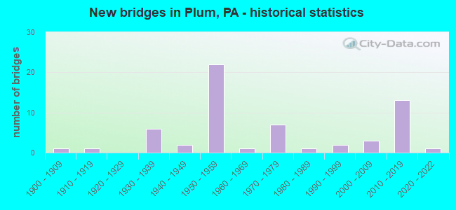
- New bridges - historical statistics
- 11900-1909
- 11910-1919
- 61930-1939
- 21940-1949
- 221950-1959
- 11960-1969
- 71970-1979
- 11980-1989
- 21990-1999
- 32000-2009
- 132010-2019
- 12020-2022

- Reconstructed bridges - Historical Statistics
- 31980-1989
- 31990-1999
- 32000-2009
- 32010-2019


- Bridge Condition - Deck
- 6.1%Excellent
- 21.2%Very good
- 36.4%Good
- 9.1%Satisfactory
- 21.2%Fair
- 6.1%Poor

- Bridge Condition - Superstructure
- 2.9%Excellent
- 28.6%Very good
- 22.9%Good
- 20.0%Satisfactory
- 17.1%Fair
- 8.6%Poor

- Bridge Condition - Substructure
- 14.3%Very good
- 37.1%Good
- 22.9%Satisfactory
- 22.9%Fair
- 2.9%Poor

- Bridge Condition - Channel
- 3.2%Excellent
- 12.9%Very good
- 25.8%Good
- 22.6%Satisfactory
- 12.9%Fair
- 19.4%Poor
- 3.2%Serious

- Bridge Condition - Culverts
- 11.1%Excellent
- 33.3%Satisfactory
- 33.3%Fair
- 11.1%Poor
- 11.1%Serious
Find on map >> Show street view
Structure Number: 49131, Location: 300' N SR 286 (Lat: 40.455436, Lng: -79.712061), Route carried "on" structure: City street , Year Built: 1995, Status: Open, Structure Length: 0.70m (2.30ft), Average Daily Traffic: 250 (year 2019), Truck Traffic: 1%, Average Future Daily Traffic: 300 (year 2039), Design Load: HS 20, Features Intersected: Humms Run, Facility Carried by Structure: Pine Valley Dr.
Minimum Vertical Clearance: 30+ m (98+ ft), Kilometerpoint: 0.000, Lanes on structure: 2, Owner: City or Municipal Highway Agency, Approaching Roadway Width: 7.9m (25.9ft), Material/Design: Steel, Design/Construction: Culvert, Number Of Spans In Main Unit: 1, Length of Maximum Span: 7.0m (23.0ft)
Condition: Channel: Satisfactory, Culverts: Fair, Operating Rating: 49.0 metric tons, Method Used To Determine Operating Rating: Field evaluation and documented engineering judgment, Inventory Rating: 32.7 metric tons, Method Used To Determine Inventory Rating: Field evaluation and documented engineering judgment, Structural Evaluation: Somewhat better than minimum adequacy, Waterway Adequacy: Better than present minimum criteria, Approach Roadway Alignment: Equal to present desirable criteria, Designated Inspection Frequency: Every 24 months, Inspection Date: April 2021
Find on map >> Show street view
Structure Number: 53337, Location: W of Allegheny Val Int. (Lat: 40.551481, Lng: -79.829825), Route carried "on" structure: Interstate 76, Year Built: 2016, Status: Open, Structure Length: 4.75m (15.58ft), Average Daily Traffic: 33,531 (year 2004), Truck Traffic: 19%, Average Future Daily Traffic: 44,221 (year 2030), Design Load: HL 93, Features Intersected: Deer Creek
Minimum Vertical Clearance: 30+ m (98+ ft), Kilometerpoint: 0.000, Lanes on structure: 4, Base Highway Network: Yes, Toll: Toll bridge, Owner: State Toll Authority, Approaching Roadway Width: 37.2m (122.0ft), Skew: 30 degrees, Material/Design: Prestressed concrete, Design/Construction: Tee Beam, Number Of Spans In Main Unit: 1, Length of Maximum Span: 46.9m (153.9ft), Curb or Sidewalk Widths: Left: 0.2m (0.7ft), Right: 0.2m (0.7ft), Curb-To-Curb Width: 37.2m (122.0ft), Out-to-Out Width: 38.2m (125.3ft)
Condition: Deck: Very good, Superstructure: Very good, Substructure: Good, Channel: Very good, Operating Rating: 66.1 metric tons, Method Used To Determine Operating Rating: Assigned ratings based on Load and Resistance Factor Design (LRFD) reported by rating factor (RF) using HL93 loadings, Inventory Rating: 32.4 metric tons, Method Used To Determine Inventory Rating: Assigned ratings based on Load and Resistance Factor Design (LRFD) reported by rating factor (RF) using HL93 loadings, Structural Evaluation: Better than present minimum criteria, Deck Geometry: Superior to present desirable criteria, Waterway Adequacy: Superior to present desirable criteria, Approach Roadway Alignment: Equal to present desirable criteria, Designated Inspection Frequency: Every 48 months, Inspection Date: May 2018, Deck Structure Type: Concrete Cast-file-Place, Wearing Surface/Protective System: Wearing Surface: Monolithic Concrete, Deck Protection: Epoxy Coated Reinforcing
Find on map >> Show street view
Structure Number: 53653, Location: 1/2 mi. NW of SR1028 (Lat: 40.450806, Lng: -79.713444), Route carried "on" structure: State highway , Year Built: 2017, Status: Open, Structure Length: 1.77m (5.81ft), Average Daily Traffic: 219 (year 2020), Truck Traffic: 15%, Average Future Daily Traffic: 513 (year 2032), Design Load: HL 93, Features Intersected: Lardington Run, Facility Carried by Structure: Lardington Road
Minimum Vertical Clearance: 30+ m (98+ ft), Kilometerpoint: 1.118, Lanes on structure: 2, Owner: State Highway Agency, Approaching Roadway Width: 7.9m (25.9ft), Skew: 1 degrees, Material/Design: Prestressed concrete, Design/Construction: Box Beam or Girders - Single/Spread, Number Of Spans In Main Unit: 1, Length of Maximum Span: 16.8m (55.1ft), Curb or Sidewalk Widths: Left: 0.2m (0.7ft), Right: 0.2m (0.7ft), Curb-To-Curb Width: 10.2m (33.5ft), Out-to-Out Width: 11.3m (37.1ft)
Condition: Deck: Very good, Superstructure: Very good, Substructure: Very good, Channel: Good, Operating Rating: 46.3 metric tons, Method Used To Determine Operating Rating: Assigned ratings based on Load and Resistance Factor Design (LRFD) reported by rating factor (RF) using HL93 loadings, Inventory Rating: 35.6 metric tons, Method Used To Determine Inventory Rating: Assigned ratings based on Load and Resistance Factor Design (LRFD) reported by rating factor (RF) using HL93 loadings, Structural Evaluation: Equal to present desirable criteria, Deck Geometry: Better than present minimum criteria, Waterway Adequacy: Better than present minimum criteria, Approach Roadway Alignment: Better than present minimum criteria, Designated Inspection Frequency: Every 24 months, Inspection Date: January 2021, Deck Structure Type: Concrete Cast-file-Place, Wearing Surface/Protective System: Wearing Surface: Monolithic Concrete, Deck Protection: Epoxy Coated Reinforcing
Find on map >> Show street view
Structure Number: 55084, Location: Milepost 53.66 (Lat: 40.475358, Lng: -79.767211), Route carried "on" structure: State highway 380, Year Built: 2018, Status: Open, Structure Length: 6.43m (21.10ft), Average Future Daily Traffic: 13,354 (year 2030), Design Load: HL 93, Features Intersected: PA Turnpike - I-76, Facility Carried by Structure: SR 400, LR228
Minimum Vertical Clearance: 30+ m (98+ ft), Kilometerpoint: 24.111, Lanes on structure: 2, Lanes under structure: 4, Base Highway Network: Yes, Owner: State Toll Authority, Approaching Roadway Width: 12.2m (40.0ft), Skew: 1 degrees, Material/Design: Prestressed concrete continuous, Design/Construction: Stringer/Multi-beam, Number Of Spans In Main Unit: 2, Length of Maximum Span: 35.4m (116.1ft), Curb or Sidewalk Widths: Left: 0.2m (0.7ft), Right: 0.2m (0.7ft), Curb-To-Curb Width: 12.2m (40.0ft), Out-to-Out Width: 13.3m (43.6ft)
Condition: Deck: Excellent, Superstructure: Very good, Substructure: Very good, Operating Rating: 43.4 metric tons, Method Used To Determine Operating Rating: Assigned ratings based on Load and Resistance Factor Design (LRFD) reported by rating factor (RF) using HL93 loadings, Inventory Rating: 33.4 metric tons, Method Used To Determine Inventory Rating: Assigned ratings based on Load and Resistance Factor Design (LRFD) reported by rating factor (RF) using HL93 loadings, Structural Evaluation: Equal to present desirable criteria, Deck Geometry: Superior to present desirable criteria, Underclear: Superior to present desirable criteria, Approach Roadway Alignment: Better than present minimum criteria, Designated Inspection Frequency: Every 24 months, Inspection Date: August 2020, Deck Structure Type: Concrete Cast-file-Place, Wearing Surface/Protective System: Wearing Surface: Monolithic Concrete, Deck Protection: Epoxy Coated Reinforcing
Find on map >> Show street view
Structure Number: 67876, Location: NEAR PENN HILLS (Lat: 40.489983, Lng: -79.781194), Route carried "on" structure: County highway LOCL, Year Built: 2019, Status: Open, Structure Length: 5.91m (19.39ft), Average Daily Traffic: 4,396 (year 2020), Truck Traffic: 5%, Average Future Daily Traffic: 4,396 (year 2020), Design Load: HL 93, Features Intersected: PA TPK (I-76), Facility Carried by Structure: Unity Center Road
Minimum Vertical Clearance: 30+ m (98+ ft), Kilometerpoint: 84.265, Lanes on structure: 2, Lanes under structure: 4, Owner: State Toll Authority, Approaching Roadway Width: 9.8m (32.2ft), Skew: 3 degrees, Material/Design: Prestressed concrete continuous, Design/Construction: Box Beam or Girders - Single/Spread, Number Of Spans In Main Unit: 2, Length of Maximum Span: 33.2m (108.9ft), Curb or Sidewalk Widths: Left: 0.2m (0.7ft), Right: 0.2m (0.7ft), Curb-To-Curb Width: 9.8m (32.2ft), Out-to-Out Width: 10.9m (35.8ft)
Condition: Deck: Very good, Superstructure: Very good, Substructure: Very good, Operating Rating: 48.3 metric tons, Method Used To Determine Operating Rating: Assigned ratings based on Load and Resistance Factor Design (LRFD) reported by rating factor (RF) using HL93 loadings, Inventory Rating: 37.3 metric tons, Method Used To Determine Inventory Rating: Assigned ratings based on Load and Resistance Factor Design (LRFD) reported by rating factor (RF) using HL93 loadings, Structural Evaluation: Equal to present desirable criteria, Deck Geometry: Meets minimum limits, Underclear: High priority of corrective action, Approach Roadway Alignment: Better than present minimum criteria, Designated Inspection Frequency: Every 24 months, Inspection Date: November 2020, Deck Structure Type: Concrete Cast-file-Place, Wearing Surface/Protective System: Wearing Surface: Monolithic Concrete, Deck Protection: Epoxy Coated Reinforcing
Find on map >> Show street view
Structure Number: 68612, Location: PM06 - PLUM CREEK NO. 6 (Lat: 40.508922, Lng: -79.747042), Route carried "on" structure: County highway , Year Built: 2021, Status: Open, Structure Length: 1.01m (3.31ft), Average Daily Traffic: 53 (year 2021), Truck Traffic: 10%, Average Future Daily Traffic: 63 (year 2041), Design Load: HL 93, Features Intersected: PLUM CREEK, Facility Carried by Structure: STOTLER RD
Minimum Vertical Clearance: 30+ m (98+ ft), Kilometerpoint: 0.000, Lanes on structure: 2, Owner: County Highway Agency, Approaching Roadway Width: 6.7m (22.0ft), Material/Design: Concrete, Design/Construction: Culvert, Number Of Spans In Main Unit: 1, Length of Maximum Span: 7.3m (24.0ft), Curb-To-Curb Width: 6.7m (22.0ft), Out-to-Out Width: 7.8m (25.6ft)
Condition: Channel: Excellent, Culverts: Excellent, Operating Rating: 42.1 metric tons, Method Used To Determine Operating Rating: Assigned ratings based on Load and Resistance Factor Design (LRFD) reported by rating factor (RF) using HL93 loadings, Inventory Rating: 35.6 metric tons, Method Used To Determine Inventory Rating: Assigned ratings based on Load and Resistance Factor Design (LRFD) reported by rating factor (RF) using HL93 loadings, Structural Evaluation: Superior to present desirable criteria, Deck Geometry: Somewhat better than minimum adequacy, Waterway Adequacy: Superior to present desirable criteria, Approach Roadway Alignment: Equal to present desirable criteria, Designated Inspection Frequency: Every 24 months, Inspection Date: November 2021
Find on map >> Show street view
Structure Number: 637, Location: SR 28 NB OVER TURNPIKE (Lat: 40.548011, Lng: -79.824828), Route carried "under" structure: Interstate 76, Year Built: 1970, Structure Length: 0. m, Average Daily Traffic: 1 (year 2004), Truck Traffic: 1%, Features Intersected: PA TURNPIKE, Facility Carried by Structure: SR 0028 NB
Minimum Vertical Clearance: 5.64m (18.50ft), Kilometerpoint: 0.000, Lanes on structure: 3, Lanes under structure: 4, Toll: On toll road, Material/Design: Steel, Design/Construction: Stringer/Multi-beam, Length of Maximum Span: 34.7m (113.8ft)
Find on map >> Show street view
Structure Number: 639, Location: SR 28 SB OVER TURNPIKE (Lat: 40.548214, Lng: -79.824714), Route carried "under" structure: Interstate 76, Year Built: 1970, Structure Length: 0. m, Average Daily Traffic: 1 (year 2004), Truck Traffic: 1%, Features Intersected: PA TURNPIKE, Facility Carried by Structure: SR 0028 SB
Minimum Vertical Clearance: 5.26m (17.26ft), Kilometerpoint: 0.000, Lanes on structure: 2, Lanes under structure: 4, Toll: On toll road, Material/Design: Steel, Design/Construction: Stringer/Multi-beam, Length of Maximum Span: 34.7m (113.8ft)
Find on map >> Show street view
Structure Number: 2085, Location: ALLEGHENY VAL.INT. RAMP F (Lat: 40.540456, Lng: -79.822819), Route carried "under" structure: State highway , Year Built: 1952, Structure Length: 0. m, Average Daily Traffic: 7,542 (year 2022), Truck Traffic: 7%, Features Intersected: SR 1001 NB, Facility Carried by Structure: PA TURNPIKE RAMP F
Minimum Vertical Clearance: 4.56m (14.96ft), Kilometerpoint: 14.624, Lanes on structure: 1, Lanes under structure: 4, Material/Design: Steel, Design/Construction: Stringer/Multi-beam, Length of Maximum Span: 23.2m (76.1ft)
Find on map >> Show street view
Structure Number: 2085, Location: ALLEGHENY VAL.INT. RAMP F (Lat: 40.540456, Lng: -79.822819), Route carried "under" structure: State highway , Year Built: 1952, Structure Length: 0. m, Average Daily Traffic: 7,542 (year 2022), Truck Traffic: 7%, Features Intersected: SR 1001 NB, Facility Carried by Structure: PA TURNPIKE RAMP F
Minimum Vertical Clearance: 4.56m (14.96ft), Kilometerpoint: 14.614, Lanes on structure: 1, Lanes under structure: 4, Material/Design: Steel, Design/Construction: Stringer/Multi-beam, Length of Maximum Span: 23.2m (76.1ft)
Find on map >> Show street view
Structure Number: 2086, Location: ALLEGHENY VAL.INT.RAMPG (Lat: 40.540314, Lng: -79.822786), Route carried "under" structure: State highway , Year Built: 1939, Structure Length: 0. m, Average Daily Traffic: 7,542 (year 2022), Truck Traffic: 7%, Features Intersected: SR 1001, Facility Carried by Structure: PA TURNPIKE RAMP G
Minimum Vertical Clearance: 5.24m (17.19ft), Kilometerpoint: 14.624, Lanes on structure: 1, Lanes under structure: 2, Material/Design: Steel, Design/Construction: Stringer/Multi-beam, Length of Maximum Span: 22.9m (75.1ft)
Find on map >> Show street view
Structure Number: 2086, Location: ALLEGHENY VAL.INT.RAMPG (Lat: 40.540314, Lng: -79.822786), Route carried "under" structure: State highway , Year Built: 1939, Structure Length: 0. m, Average Daily Traffic: 7,542 (year 2022), Truck Traffic: 7%, Features Intersected: SR 1001, Facility Carried by Structure: PA TURNPIKE RAMP G
Minimum Vertical Clearance: 4.73m (15.52ft), Kilometerpoint: 14.614, Lanes on structure: 1, Lanes under structure: 2, Material/Design: Steel, Design/Construction: Stringer/Multi-beam, Length of Maximum Span: 22.9m (75.1ft)
Find on map >> Show street view
Structure Number: 2091, Location: WEST OF MILLTOWN (Lat: 40.520000, Lng: -79.806667), Route carried "under" structure: State highway , Year Built: 1952, Structure Length: 0. m, Average Daily Traffic: 6,556 (year 2022), Truck Traffic: 7%, Features Intersected: HULTON RD, Facility Carried by Structure: PA TPK (I-76)
Minimum Vertical Clearance: 4.30m (14.11ft), Kilometerpoint: 15.086, Lanes on structure: 4, Lanes under structure: 2, Material/Design: Steel, Design/Construction: Stringer/Multi-beam, Length of Maximum Span: 15.8m (51.8ft)
Find on map >> Show street view
Structure Number: 2092, Location: NEAR MILLTOWN (Lat: 40.506667, Lng: -79.788333), Route carried "under" structure: City street , Year Built: 1952, Structure Length: 0. m, Average Daily Traffic: 200 (year 1992), Features Intersected: T-732, Facility Carried by Structure: PA TPK (I-76)
Minimum Vertical Clearance: 4.54m (14.90ft), Kilometerpoint: 0.000, Lanes on structure: 4, Lanes under structure: 2, Toll: On toll road, Material/Design: Prestressed concrete, Design/Construction: Box Beam or Girders - Multiple, Length of Maximum Span: 7.9m (25.9ft)
Find on map >> Show street view
Structure Number: 2093, Location: NEAR MILLTOWN (Lat: 40.511839, Lng: -79.791486), Route carried "under" structure: State highway , Year Built: 1952, Structure Length: 0. m, Average Daily Traffic: 1,836 (year 2021), Truck Traffic: 5%, Features Intersected: SR 2084, Milltown Road, Facility Carried by Structure: PA TPK (I-76)
Minimum Vertical Clearance: 5.59m (18.34ft), Kilometerpoint: 0.275, Lanes on structure: 4, Lanes under structure: 2, Material/Design: Concrete, Design/Construction: Culvert, Length of Maximum Span: 11.3m (37.1ft)
Find on map >> Show street view
Structure Number: 2094, Location: NEAR PENN HILLS (Lat: 40.495000, Lng: -79.783333), Route carried "under" structure: City street , Year Built: 1952, Structure Length: 0. m, Features Intersected: SR 2086, PLUM CR,ABANDRR, Facility Carried by Structure: PA TPK (I-76)
Minimum Vertical Clearance: 30+ m (98+ ft), Kilometerpoint: 0.000, Lanes on structure: 4, Lanes under structure: 4, Toll: On toll road, Material/Design: Steel, Design/Construction: Girder and Floorbeam System, Length of Maximum Span: 38.1m (125.0ft)
Find on map >> Show street view
Structure Number: 2094, Location: NEAR PENN HILLS (Lat: 40.495000, Lng: -79.783333), Route carried "under" structure: State highway , Year Built: 1952, Structure Length: 0. m, Average Daily Traffic: 3,578 (year 2022), Truck Traffic: 6%, Features Intersected: SR 2086, PLUM CR,ABANDRR, Facility Carried by Structure: PA TPK (I-76)
Minimum Vertical Clearance: 20.43m (67.03ft), Kilometerpoint: 0.776, Lanes on structure: 4, Lanes under structure: 4, Material/Design: Steel, Design/Construction: Girder and Floorbeam System, Length of Maximum Span: 38.1m (125.0ft)
Find on map >> Show street view
Structure Number: 2097, Location: NEAR PENN HILLS (Lat: 40.485000, Lng: -79.773333), Route carried "under" structure: City street , Year Built: 1952, Structure Length: 0. m, Average Daily Traffic: 200 (year 1992), Features Intersected: T-746, Facility Carried by Structure: PA TPK (I-76)
Minimum Vertical Clearance: 3.88m (12.73ft), Kilometerpoint: 0.000, Lanes on structure: 4, Lanes under structure: 2, Toll: On toll road, Material/Design: Prestressed concrete, Design/Construction: Box Beam or Girders - Multiple, Length of Maximum Span: 9.1m (29.9ft)
Find on map >> Show street view
Structure Number: 46492, Location: Allegheny River (Lat: 40.538333, Lng: -79.821667), Route carried "under" structure: State highway , Year Built: 2010, Structure Length: 0. m, Average Daily Traffic: 7,542 (year 2022), Truck Traffic: 7%, Features Intersected: SR1001, N.S., AV. R, Facility Carried by Structure: PA TPK (I-76) WB
Minimum Vertical Clearance: 30+ m (98+ ft), Kilometerpoint: 14.624, Lanes on structure: 3, Lanes under structure: 2, Material/Design: Concrete continuous, Design/Construction: Segmental Box Girder, Length of Maximum Span: 162.2m (532.2ft)
Find on map >> Show street view
Structure Number: 46492, Location: Allegheny River (Lat: 40.538333, Lng: -79.821667), Route carried "under" structure: State highway , Year Built: 2010, Structure Length: 0. m, Average Daily Traffic: 7,542 (year 2022), Truck Traffic: 7%, Features Intersected: SR1001, N.S., AV. R, Facility Carried by Structure: PA TPK (I-76) WB
Minimum Vertical Clearance: 30+ m (98+ ft), Kilometerpoint: 14.614, Lanes on structure: 3, Lanes under structure: 3, Material/Design: Concrete continuous, Design/Construction: Segmental Box Girder, Length of Maximum Span: 162.2m (532.2ft)
Find on map >> Show street view
Structure Number: 46493, Location: Allegheny River (Lat: 40.538333, Lng: -79.821667), Route carried "under" structure: State highway , Year Built: 2010, Structure Length: 0. m, Average Daily Traffic: 7,542 (year 2022), Truck Traffic: 7%, Features Intersected: SR 1001, N.S. & A.V. RR, Facility Carried by Structure: PA TPK (I-76) EB
Minimum Vertical Clearance: 16.04m (52.62ft), Kilometerpoint: 14.624, Lanes on structure: 3, Lanes under structure: 4, Material/Design: Concrete continuous, Design/Construction: Segmental Box Girder, Length of Maximum Span: 162.2m (532.2ft)
Find on map >> Show street view
Structure Number: 46493, Location: Allegheny River (Lat: 40.538333, Lng: -79.821667), Route carried "under" structure: State highway , Year Built: 2010, Structure Length: 0. m, Average Daily Traffic: 7,542 (year 2022), Truck Traffic: 7%, Features Intersected: SR 1001, N.S. & A.V. RR, Facility Carried by Structure: PA TPK (I-76) EB
Minimum Vertical Clearance: 16.38m (53.74ft), Kilometerpoint: 14.614, Lanes on structure: 3, Lanes under structure: 1, Material/Design: Concrete continuous, Design/Construction: Segmental Box Girder, Length of Maximum Span: 162.2m (532.2ft)