Bridge Statistics for Princeton, New Jersey (NJ)
Condition, Traffic, Stress, Structural Evaluation, Project Costs
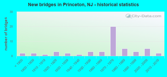
- New bridges - historical statistics
- 2Before 1900
- 21900-1909
- 11910-1919
- 31920-1929
- 21930-1939
- 11940-1949
- 31950-1959
- 31960-1969
- 201970-1979
- 51980-1989
- 31990-1999
- 52000-2009
- 22010-2019
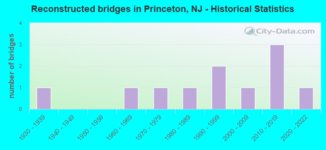
- Reconstructed bridges - Historical Statistics
- 11930-1939
- 01940-1949
- 01950-1959
- 11960-1969
- 11970-1979
- 11980-1989
- 21990-1999
- 12000-2009
- 32010-2019
- 12020-2022
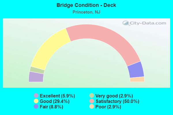
- Bridge Condition - Deck
- 5.9%Excellent
- 2.9%Very good
- 29.4%Good
- 50.0%Satisfactory
- 8.8%Fair
- 2.9%Poor
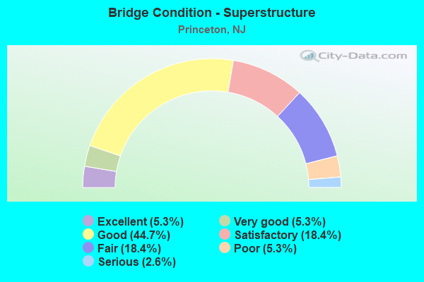
- Bridge Condition - Superstructure
- 5.3%Excellent
- 5.3%Very good
- 44.7%Good
- 18.4%Satisfactory
- 18.4%Fair
- 5.3%Poor
- 2.6%Serious

- Bridge Condition - Substructure
- 5.3%Excellent
- 10.5%Very good
- 34.2%Good
- 23.7%Satisfactory
- 18.4%Fair
- 5.3%Poor
- 2.6%Serious
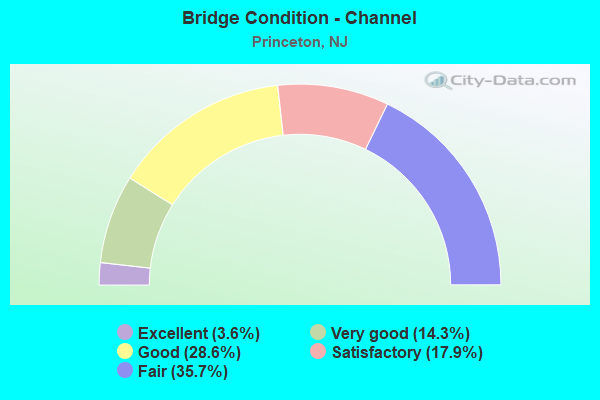
- Bridge Condition - Channel
- 3.6%Excellent
- 14.3%Very good
- 28.6%Good
- 17.9%Satisfactory
- 35.7%Fair
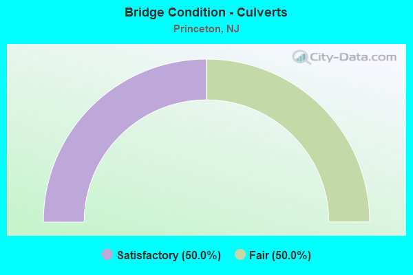
- Bridge Condition - Culverts
- 50.0%Satisfactory
- 50.0%Fair
Find on map >> Show street view
Structure Number: 3000157, Location: 0.5 MI W OF US RT 1 JCT (Lat: 40.342150, Lng: -74.637289), Route carried "on" structure: County highway 629, Year Built: 1989, Status: Open, Structure Length: 1.71m (5.61ft), Average Daily Traffic: 11,444 (year 2020), Truck Traffic: 4%, Average Future Daily Traffic: 13,733 (year 2040), Design Load: HS 20+Mod, Features Intersected: DELAWARE & RARITAN CANAL, Facility Carried by Structure: HARRISON STREET
Minimum Vertical Clearance: 30+ m (98+ ft), Kilometerpoint: 1.046, Lanes on structure: 2, Owner: State Agenciy, Maintenance Responsibility: State Highway Agency, Approaching Roadway Width: 8.8m (28.9ft), Material/Design: Prestressed concrete, Design/Construction: Slab, Number Of Spans In Main Unit: 1, Length of Maximum Span: 15.8m (51.8ft), Curb or Sidewalk Widths: Left: 1.8m (5.9ft), Right: 1.8m (5.9ft), Curb-To-Curb Width: 9.1m (29.9ft), Out-to-Out Width: 13.4m (44.0ft)
Condition: Deck: Good, Superstructure: Very good, Substructure: Good, Channel: Very good, Inventory Rating: 59.9 metric tons, Method Used To Determine Inventory Rating: Load Factor (LF), Structural Evaluation: Better than present minimum criteria, Deck Geometry: High priority of corrective action, Waterway Adequacy: Equal to present desirable criteria, Approach Roadway Alignment: Somewhat better than minimum adequacy, Length Of Structure Improvement: 1.71m (5.61ft), Designated Inspection Frequency: Every 24 months, Underwater Inspection Frequency: Every 48 months, Inspection Date: Febuary 2020, Underwater Inspection Date: March 2020, Bridge Improvement Cost: $18,000, Roadway Improvement Cost: $17,000, Total Project Cost: $49,000 ( Estimate for 2020), Deck Structure Type: Concrete Cast-file-Place, Wearing Surface/Protective System: Wearing Surface: Monolithic Concrete, Deck Protection: Epoxy Coated Reinforcing
Find on map >> Show street view
Structure Number: 1103157, Location: 1.3 MI N.OF I-295 & RT1 (Lat: 40.297861, Lng: -74.678911), Route carried "under" structure: US 1, Year Built: 1987, Structure Length: 0. m, Average Daily Traffic: 97,765 (year 2021), Truck Traffic: 4%, Features Intersected: ROUTE US 1, Facility Carried by Structure: QUAKER BRIDGE ROAD
Minimum Vertical Clearance: 5.46m (17.91ft), Kilometerpoint: 13.036, Lanes on structure: 6, Lanes under structure: 10, Material/Design: Steel, Design/Construction: Stringer/Multi-beam, Length of Maximum Span: 39.3m (128.9ft)
Find on map >> Show street view
Structure Number: 1103159, Location: 2.7 MI NORTH OF I-295 JCT (Lat: 40.312011, Lng: -74.662050), Route carried "under" structure: US 1, Year Built: 2003, Structure Length: 0. m, Average Daily Traffic: 87,497 (year 2021), Truck Traffic: 4%, Features Intersected: US ROUTE 1, Facility Carried by Structure: MEADOW ROAD
Minimum Vertical Clearance: 6.18m (20.28ft), Kilometerpoint: 15.208, Lanes on structure: 5, Lanes under structure: 9, Material/Design: Steel continuous, Design/Construction: Stringer/Multi-beam, Length of Maximum Span: 38.1m (125.0ft)
Find on map >> Show street view
Structure Number: 1103411, Location: 0.75 MI NE OF RT295&1 JCT (Lat: 40.291661, Lng: -74.685819), Route carried "under" structure: US 1, Year Built: 1975, Structure Length: 0. m, Average Daily Traffic: 83,659 (year 2020), Truck Traffic: 4%, Features Intersected: US ROUTE 1
Minimum Vertical Clearance: 4.88m (16.01ft), Kilometerpoint: 12.151, Lanes on structure: 2, Lanes under structure: 7, Material/Design: Steel, Design/Construction: Stringer/Multi-beam, Length of Maximum Span: 42.1m (138.1ft)
Find on map >> Show street view
Structure Number: 1138162, Location: AT US 1 INTERCHANGE (Lat: 40.282369, Lng: -74.694200), Route carried "under" structure: Ramp Interstate 295, Year Built: 1974, Structure Length: 0. m, Average Daily Traffic: 5,031 (year 2021), Truck Traffic: 9%, Features Intersected: I-295 RAMP C
Minimum Vertical Clearance: 4.62m (15.16ft), Kilometerpoint: 108.663, Lanes on structure: 4, Lanes under structure: 1, Material/Design: Steel, Design/Construction: Stringer/Multi-beam, Length of Maximum Span: 21.3m (69.9ft)
Find on map >> Show street view
Structure Number: 1138163, Location: 0.11 M south of US 1 JCT. (Lat: 40.282261, Lng: -74.694969), Route carried "under" structure: Ramp Interstate 295, Year Built: 1974, Structure Length: 0. m, Average Daily Traffic: 5,255 (year 2021), Truck Traffic: 9%, Features Intersected: Ramp I-295 SB to US 1 NB
Minimum Vertical Clearance: 4.42m (14.50ft), Kilometerpoint: 108.663, Lanes on structure: 4, Lanes under structure: 1, Material/Design: Steel, Design/Construction: Stringer/Multi-beam, Length of Maximum Span: 22.6m (74.1ft)
Find on map >> Show street view
Structure Number: 1138164, Location: AT U.S 1 INTERSECTION (Lat: 40.283431, Lng: -74.696619), Route carried "under" structure: US 1, Year Built: 1974, Structure Length: 0. m, Average Daily Traffic: 78,051 (year 2019), Truck Traffic: 4%, Features Intersected: US 1 & Ramps A & B, Facility Carried by Structure: I-295 NB
Minimum Vertical Clearance: 5.31m (17.42ft), Kilometerpoint: 10.879, Lanes on structure: 5, Lanes under structure: 5, Material/Design: Steel, Design/Construction: Stringer/Multi-beam, Length of Maximum Span: 56.4m (185.0ft)
Find on map >> Show street view
Structure Number: 1138165, Location: AT US 1/I-295 INTERSECTIN (Lat: 40.283431, Lng: -74.696619), Route carried "under" structure: US 1, Year Built: 1974, Structure Length: 0. m, Average Daily Traffic: 103,454 (year 2021), Truck Traffic: 4%, Features Intersected: US 1 AND RAMPS "A" & "B", Facility Carried by Structure: I-295 SB
Minimum Vertical Clearance: 4.98m (16.34ft), Kilometerpoint: 10.879, Lanes on structure: 4, Lanes under structure: 5, Material/Design: Steel, Design/Construction: Stringer/Multi-beam, Length of Maximum Span: 53.3m (174.9ft)
Find on map >> Show street view
Structure Number: 1138165, Location: AT US 1/I-295 INTERSECTIN (Lat: 40.283431, Lng: -74.696619), Route carried "under" structure: Ramp US 1, Year Built: 1974, Structure Length: 0. m, Average Daily Traffic: 41,380 (year 2021), Truck Traffic: 4%, Features Intersected: US 1 AND RAMPS "A" & "B", Facility Carried by Structure: I-295 SB
Minimum Vertical Clearance: 4.60m (15.09ft), Kilometerpoint: 10.879, Lanes on structure: 4, Lanes under structure: 2, Material/Design: Steel, Design/Construction: Stringer/Multi-beam, Length of Maximum Span: 53.3m (174.9ft)
Find on map >> Show street view
Structure Number: 1138166, Location: AT RT 1 INTERSECTION (Lat: 40.282539, Lng: -74.697819), Route carried "under" structure: Ramp US 1, Year Built: 1974, Structure Length: 0. m, Average Daily Traffic: 8,442 (year 2021), Truck Traffic: 7%, Features Intersected: US1 AND US1 RAMP, Facility Carried by Structure: I-295 SB RAMP C
Minimum Vertical Clearance: 4.57m (14.99ft), Kilometerpoint: 10.718, Lanes on structure: 1, Lanes under structure: 1, Material/Design: Steel, Design/Construction: Stringer/Multi-beam, Length of Maximum Span: 48.2m (158.1ft)
Find on map >> Show street view
Structure Number: 1138166, Location: AT RT 1 INTERSECTION (Lat: 40.282539, Lng: -74.697819), Route carried "under" structure: US 1, Year Built: 1974, Structure Length: 0. m, Average Daily Traffic: 8,442 (year 2021), Truck Traffic: 7%, Features Intersected: US1 AND US1 RAMP, Facility Carried by Structure: I-295 SB RAMP C
Minimum Vertical Clearance: 4.55m (14.93ft), Kilometerpoint: 10.702, Lanes on structure: 1, Lanes under structure: 4, Material/Design: Steel, Design/Construction: Stringer/Multi-beam, Length of Maximum Span: 48.2m (158.1ft)
Find on map >> Show street view
Structure Number: 1201151, Location: 1.66 MI NORTH OF CR 571 (Lat: 40.348950, Lng: -74.617019), Route carried "under" structure: Other road , Year Built: 1932, Structure Length: 0. m, Average Daily Traffic: 907 (year 2022), Truck Traffic: 1%, Features Intersected: FORRESTAL ROAD, Facility Carried by Structure: US 1
Minimum Vertical Clearance: 4.27m (14.01ft), Kilometerpoint: 0.000, Lanes on structure: 6, Lanes under structure: 2, Material/Design: Steel, Design/Construction: Stringer/Multi-beam, Length of Maximum Span: 8.2m (26.9ft)
Find on map >> Show street view
Structure Number: 1201163, Location: 1.2 MI NORTH OF CO RT 571 (Lat: 40.343331, Lng: -74.623331), Route carried "under" structure: US 1, Year Built: 1995, Structure Length: 0. m, Average Daily Traffic: 88,330 (year 2021), Truck Traffic: 4%, Features Intersected: US 1, Facility Carried by Structure: SCUDDERS MILL ROAD
Minimum Vertical Clearance: 5.56m (18.24ft), Kilometerpoint: 20.069, Lanes on structure: 3, Lanes under structure: 8, Material/Design: Steel, Design/Construction: Stringer/Multi-beam, Length of Maximum Span: 28.3m (92.8ft)