Bridge Statistics for Quincy, Illinois (IL)
Condition, Traffic, Stress, Structural Evaluation, Project Costs
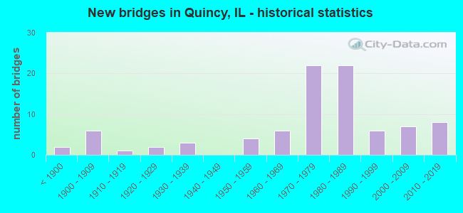
- New bridges - historical statistics
- 2Before 1900
- 61900-1909
- 11910-1919
- 21920-1929
- 31930-1939
- 41950-1959
- 61960-1969
- 221970-1979
- 221980-1989
- 61990-1999
- 72000-2009
- 82010-2019
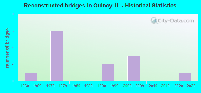
- Reconstructed bridges - Historical Statistics
- 11960-1969
- 61970-1979
- 01980-1989
- 21990-1999
- 32000-2009
- 02010-2019
- 12020-2022

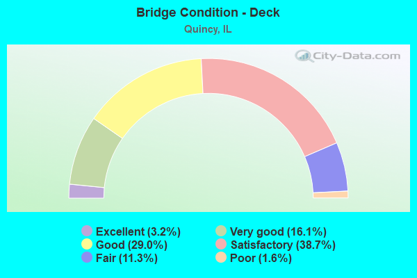
- Bridge Condition - Deck
- 3.2%Excellent
- 16.1%Very good
- 29.0%Good
- 38.7%Satisfactory
- 11.3%Fair
- 1.6%Poor
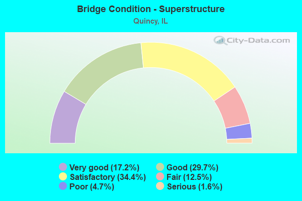
- Bridge Condition - Superstructure
- 17.2%Very good
- 29.7%Good
- 34.4%Satisfactory
- 12.5%Fair
- 4.7%Poor
- 1.6%Serious
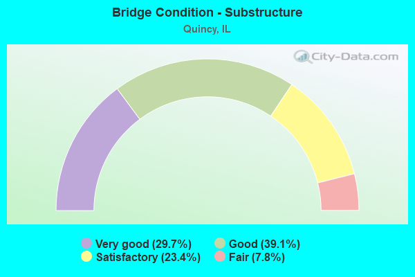
- Bridge Condition - Substructure
- 29.7%Very good
- 39.1%Good
- 23.4%Satisfactory
- 7.8%Fair
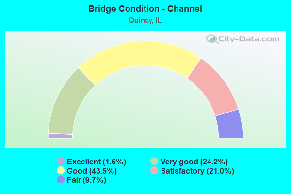
- Bridge Condition - Channel
- 1.6%Excellent
- 24.2%Very good
- 43.5%Good
- 21.0%Satisfactory
- 9.7%Fair
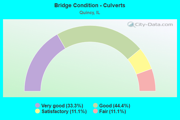
- Bridge Condition - Culverts
- 33.3%Very good
- 44.4%Good
- 11.1%Satisfactory
- 11.1%Fair
Find on map >> Show street view
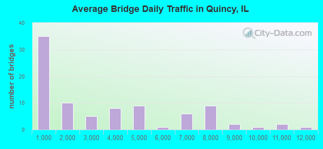
Structure Number: 10068, Location: W EDGE DWNTWN QUINCY (Lat: 39.935492, Lng: -91.415017), Route carried "under" structure: Other road , Year Built: 1986, Structure Length: 0. m, Average Daily Traffic: 1,400 (year 2019), Truck Traffic: 15%, Features Intersected: MISS. R/STREETS/BNRR, Facility Carried by Structure: US 24(WB)/ BROADWA
Minimum Vertical Clearance: 21.03m (69.00ft), Kilometerpoint: 3.315, Lanes on structure: 2, Lanes under structure: 2, Material/Design: Steel continuous, Design/Construction: Stayed Girder, Length of Maximum Span: 274.3m (899.9ft)
Find on map >> Show street view
Structure Number: 19903, Location: FRONT STREET,QUINCY (Lat: 39.954028, Lng: -91.415431), Route carried "under" structure: Other road , Year Built: 1900, Structure Length: 0. m, Average Daily Traffic: 1,150 (year 2019), Truck Traffic: 7%, Features Intersected: FAU 7818, Facility Carried by Structure: B&N RR
Minimum Vertical Clearance: 4.29m (14.07ft), Kilometerpoint: 1.255, Lanes under structure: 2, Material/Design: Concrete, Design/Construction: Slab, Length of Maximum Span: 32.0m (105.0ft)
Find on map >> Show street view
Structure Number: 19904, Location: N 12TH QUINCY (Lat: 39.956211, Lng: -91.396478), Route carried "under" structure: Other road , Year Built: 1900, Structure Length: 0. m, Average Daily Traffic: 6,300 (year 2019), Truck Traffic: 8%, Features Intersected: N 12TH STREET, Facility Carried by Structure: RAILROAD
Minimum Vertical Clearance: 4.27m (14.01ft), Kilometerpoint: 3.363, Lanes under structure: 2, Material/Design: Concrete, Design/Construction: Slab, Length of Maximum Span: 28.3m (92.8ft)
Find on map >> Show street view
Structure Number: 19906, Location: 3 M ENE QUINCY (Lat: 39.978469, Lng: -91.317831), Route carried "under" structure: County highway , Year Built: 1900, Structure Length: 0. m, Average Daily Traffic: 650 (year 2019), Truck Traffic: 4%, Features Intersected: CH 3, Facility Carried by Structure: B&N RR
Minimum Vertical Clearance: 3.89m (12.76ft), Kilometerpoint: 0.161, Lanes under structure: 2, Material/Design: Concrete, Design/Construction: Slab, Length of Maximum Span: 16.2m (53.1ft)
Find on map >> Show street view
Structure Number: 19907, Location: CEDAR ST IN QUINCY (Lat: 39.946192, Lng: -91.415214), Route carried "under" structure: County highway , Year Built: 1900, Structure Length: 0. m, Average Daily Traffic: 600 (year 2019), Truck Traffic: 6%, Features Intersected: CH 0007, Facility Carried by Structure: B&N RR
Minimum Vertical Clearance: 3.28m (10.76ft), Kilometerpoint: 0.016, Lanes under structure: 2, Material/Design: Concrete, Design/Construction: Slab, Length of Maximum Span: 3.3m (10.8ft)