Bridge Statistics for Raleigh, North Carolina (NC)
Condition, Traffic, Stress, Structural Evaluation, Project Costs
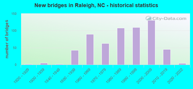
- New bridges - historical statistics
- 21920-1929
- 51930-1939
- 21940-1949
- 431950-1959
- 901960-1969
- 631970-1979
- 1081980-1989
- 1101990-1999
- 1312000-2009
- 452010-2019
- 42020-2022

- Reconstructed bridges - Historical Statistics
- 21950-1959
- 81960-1969
- 41970-1979
- 21980-1989
- 81990-1999
- 52000-2009


- Bridge Condition - Deck
- 4.3%Very good
- 55.7%Good
- 25.5%Satisfactory
- 12.9%Fair
- 1.2%Poor
- 0.4%Serious

- Bridge Condition - Superstructure
- 16.8%Very good
- 46.5%Good
- 17.2%Satisfactory
- 14.5%Fair
- 4.7%Poor
- 0.4%Serious

- Bridge Condition - Substructure
- 12.9%Very good
- 46.1%Good
- 20.7%Satisfactory
- 15.6%Fair
- 4.7%Poor

- Bridge Condition - Channel
- 0.5%Excellent
- 4.1%Very good
- 61.5%Good
- 18.8%Satisfactory
- 13.8%Fair
- 1.4%Poor

- Bridge Condition - Culverts
- 2.9%Very good
- 32.7%Good
- 41.3%Satisfactory
- 21.2%Fair
- 1.9%Poor
Find on map >> Show street view
Structure Number: 1831013, Location: 0.33 MI. N. JCT. SR2218 (Lat: 35.820731, Lng: -78.516375), Route carried "under" structure: Interstate 540, Year Built: 2005, Structure Length: 0. m, Average Daily Traffic: 31,250 (year 2019), Truck Traffic: 16%, Features Intersected: SR2217
Minimum Vertical Clearance: 5.58m (18.31ft), Kilometerpoint: 6.705, Lanes on structure: 2, Lanes under structure: 3, Material/Design: Steel continuous, Design/Construction: Stringer/Multi-beam, Length of Maximum Span: 50.2m (164.7ft)
Find on map >> Show street view
Structure Number: 1831022, Location: JCT SR 2042 & 1540 (Lat: 35.870267, Lng: -78.558483), Route carried "under" structure: Interstate 1540, Year Built: 2006, Structure Length: 0. m, Average Daily Traffic: 38,500 (year 2017), Truck Traffic: 16%, Features Intersected: SR2042, Facility Carried by Structure: I540E
Minimum Vertical Clearance: 6.34m (20.80ft), Kilometerpoint: 5.303, Lanes on structure: 2, Lanes under structure: 3, Material/Design: Steel continuous, Design/Construction: Stringer/Multi-beam, Length of Maximum Span: 37.4m (122.7ft)
Find on map >> Show street view
Structure Number: 1831022, Location: JCT SR 2042 & 1540 (Lat: 35.870267, Lng: -78.558483), Route carried "under" structure: Interstate 540, Year Built: 2006, Structure Length: 0. m, Average Daily Traffic: 38,500 (year 2017), Truck Traffic: 16%, Features Intersected: SR2042
Minimum Vertical Clearance: 5.99m (19.65ft), Kilometerpoint: 5.303, Lanes on structure: 2, Lanes under structure: 3, Material/Design: Steel continuous, Design/Construction: Stringer/Multi-beam, Length of Maximum Span: 37.4m (122.7ft)
Find on map >> Show street view
Structure Number: 1831025, Location: JCT.SR2215 &1540 (Lat: 35.846547, Lng: -78.522658), Route carried "under" structure: Interstate 540, Year Built: 2005, Structure Length: 0. m, Average Daily Traffic: 37,000 (year 2017), Truck Traffic: 16%, Features Intersected: SR2215
Minimum Vertical Clearance: 5.84m (19.16ft), Kilometerpoint: 0.000, Lanes on structure: 2, Lanes under structure: 3, Material/Design: Steel continuous, Design/Construction: Stringer/Multi-beam, Length of Maximum Span: 38.1m (125.0ft)
Find on map >> Show street view
Structure Number: 1831025, Location: JCT.SR2215 &1540 (Lat: 35.846547, Lng: -78.522658), Route carried "under" structure: Interstate 540, Year Built: 2005, Structure Length: 0. m, Average Daily Traffic: 37,000 (year 2017), Truck Traffic: 16%, Features Intersected: SR2215
Minimum Vertical Clearance: 5.38m (17.65ft), Kilometerpoint: 0.000, Lanes on structure: 2, Lanes under structure: 3, Material/Design: Steel continuous, Design/Construction: Stringer/Multi-beam, Length of Maximum Span: 38.1m (125.0ft)
Find on map >> Show street view
Structure Number: 1831037, Location: 1.74 MI. W. JCT SR1005 (Lat: 35.914806, Lng: -78.681833), Route carried "under" structure: State highway 50, Year Built: 2001, Structure Length: 0. m, Average Daily Traffic: 15,000 (year 2013), Truck Traffic: 6%, Features Intersected: I540W
Minimum Vertical Clearance: 5.66m (18.57ft), Kilometerpoint: 0.000, Lanes on structure: 3, Lanes under structure: 4, Material/Design: Steel, Design/Construction: Stringer/Multi-beam, Length of Maximum Span: 33.8m (110.9ft)
Find on map >> Show street view
Structure Number: 1831037, Location: 1.74 MI. W. JCT SR1005 (Lat: 35.914806, Lng: -78.681833), Route carried "under" structure: State highway 50, Year Built: 2001, Structure Length: 0. m, Average Daily Traffic: 15,000 (year 2013), Truck Traffic: 6%, Features Intersected: I540W
Minimum Vertical Clearance: 5.43m (17.81ft), Kilometerpoint: 0.000, Lanes on structure: 3, Lanes under structure: 4, Material/Design: Steel, Design/Construction: Stringer/Multi-beam, Length of Maximum Span: 33.8m (110.9ft)
Find on map >> Show street view
Structure Number: 1831038, Location: 1.74 MI.W. JCT. SR1005 (Lat: 35.914528, Lng: -78.681833), Route carried "under" structure: State highway 50, Year Built: 2001, Structure Length: 0. m, Average Daily Traffic: 16,250 (year 2019), Truck Traffic: 6%, Features Intersected: I540E
Minimum Vertical Clearance: 5.84m (19.16ft), Kilometerpoint: 2.895, Lanes on structure: 3, Lanes under structure: 3, Material/Design: Steel, Design/Construction: Stringer/Multi-beam, Length of Maximum Span: 33.8m (110.9ft)
Find on map >> Show street view
Structure Number: 1831038, Location: 1.74 MI.W. JCT. SR1005 (Lat: 35.914528, Lng: -78.681833), Route carried "under" structure: State highway 50, Year Built: 2001, Structure Length: 0. m, Average Daily Traffic: 16,250 (year 2019), Truck Traffic: 6%, Features Intersected: I540E
Minimum Vertical Clearance: 6.09m (19.98ft), Kilometerpoint: 2.895, Lanes on structure: 3, Lanes under structure: 4, Material/Design: Steel, Design/Construction: Stringer/Multi-beam, Length of Maximum Span: 33.8m (110.9ft)
Find on map >> Show street view
Structure Number: 1831039, Location: 0.6 MI. N. JCT. SR2697 (Lat: 35.773997, Lng: -78.549058), Route carried "under" structure: Interstate 495, Year Built: 2003, Structure Length: 0. m, Average Daily Traffic: 48,000 (year 2019), Truck Traffic: 16%, Features Intersected: SR2517
Minimum Vertical Clearance: 5.94m (19.49ft), Kilometerpoint: 128.322, Lanes on structure: 4, Lanes under structure: 3, Material/Design: Steel continuous, Design/Construction: Stringer/Multi-beam, Length of Maximum Span: 71.0m (232.9ft)
Find on map >> Show street view
Structure Number: 1831039, Location: 0.6 MI. N. JCT. SR2697 (Lat: 35.773997, Lng: -78.549058), Route carried "under" structure: Interstate 495, Year Built: 2003, Structure Length: 0. m, Average Daily Traffic: 48,000 (year 2019), Truck Traffic: 16%, Features Intersected: SR2517
Minimum Vertical Clearance: 6.67m (21.88ft), Kilometerpoint: 128.322, Lanes on structure: 4, Lanes under structure: 3, Material/Design: Steel continuous, Design/Construction: Stringer/Multi-beam, Length of Maximum Span: 71.0m (232.9ft)
Find on map >> Show street view
Structure Number: 183104, Location: 0.1 MI. N. JCT. SR4413 (Lat: 35.861833, Lng: -78.548867), Route carried "under" structure: Interstate 540, Year Built: 2001, Structure Length: 0. m, Average Daily Traffic: 36,000 (year 2018), Truck Traffic: 16%, Features Intersected: US401
Minimum Vertical Clearance: 5.54m (18.18ft), Kilometerpoint: 5.486, Lanes on structure: 6, Lanes under structure: 3, Material/Design: Prestressed concrete continuous, Design/Construction: Stringer/Multi-beam, Length of Maximum Span: 26.5m (86.9ft)
Find on map >> Show street view
Structure Number: 183104, Location: 0.1 MI. N. JCT. SR4413 (Lat: 35.861833, Lng: -78.548867), Route carried "under" structure: Interstate 540, Year Built: 2001, Structure Length: 0. m, Average Daily Traffic: 36,000 (year 2018), Truck Traffic: 16%, Features Intersected: US401
Minimum Vertical Clearance: 5.73m (18.80ft), Kilometerpoint: 5.486, Lanes on structure: 6, Lanes under structure: 3, Material/Design: Prestressed concrete continuous, Design/Construction: Stringer/Multi-beam, Length of Maximum Span: 26.5m (86.9ft)
Find on map >> Show street view
Structure Number: 1831042, Location: 0.4 MI. N. JCT. SR2000 (Lat: 35.899656, Lng: -78.622708), Route carried "under" structure: Interstate 540, Year Built: 2001, Structure Length: 0. m, Average Daily Traffic: 49,250 (year 2019), Truck Traffic: 16%, Features Intersected: SR2005
Minimum Vertical Clearance: 5.36m (17.59ft), Kilometerpoint: 3.931, Lanes on structure: 2, Lanes under structure: 3, Material/Design: Prestressed concrete continuous, Design/Construction: Stringer/Multi-beam, Length of Maximum Span: 32.0m (105.0ft)
Find on map >> Show street view
Structure Number: 1831042, Location: 0.4 MI. N. JCT. SR2000 (Lat: 35.899656, Lng: -78.622708), Route carried "under" structure: Interstate 540, Year Built: 2001, Structure Length: 0. m, Average Daily Traffic: 49,250 (year 2019), Truck Traffic: 16%, Features Intersected: SR2005
Minimum Vertical Clearance: 5.24m (17.19ft), Kilometerpoint: 3.931, Lanes on structure: 2, Lanes under structure: 3, Material/Design: Prestressed concrete continuous, Design/Construction: Stringer/Multi-beam, Length of Maximum Span: 32.0m (105.0ft)