Bridge Statistics for Reidsville, North Carolina (NC)
Condition, Traffic, Stress, Structural Evaluation, Project Costs
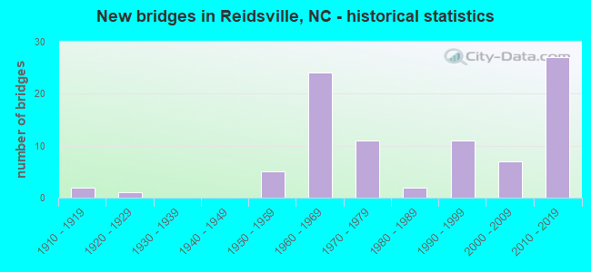
- New bridges - historical statistics
- 21910-1919
- 11920-1929
- 51950-1959
- 241960-1969
- 111970-1979
- 21980-1989
- 111990-1999
- 72000-2009
- 272010-2019

- Reconstructed bridges - Historical Statistics
- 21910-1919
- 01920-1929
- 11930-1939
- 01940-1949
- 01950-1959
- 01960-1969
- 01970-1979
- 21980-1989


- Bridge Condition - Deck
- 26.9%Very good
- 40.4%Good
- 19.2%Satisfactory
- 5.8%Fair
- 7.7%Poor

- Bridge Condition - Superstructure
- 32.7%Very good
- 30.8%Good
- 9.6%Satisfactory
- 13.5%Fair
- 13.5%Poor

- Bridge Condition - Substructure
- 34.6%Very good
- 19.2%Good
- 15.4%Satisfactory
- 17.3%Fair
- 13.5%Poor

- Bridge Condition - Channel
- 2.0%Very good
- 85.7%Good
- 4.1%Satisfactory
- 6.1%Fair
- 2.0%Poor

- Bridge Condition - Culverts
- 20.0%Very good
- 20.0%Good
- 26.7%Satisfactory
- 33.3%Fair
Find on map >> Show street view
Structure Number: 157014, Location: 0.8 MI. S. JCT. US311 (Lat: 36.374553, Lng: -79.992428), Route carried "on" structure: State highway 1138, Year Built: 1957, Status: Posted for load, Structure Length: 12.49m (40.98ft), Average Daily Traffic: 850 (year 2018), Truck Traffic: 6%, Average Future Daily Traffic: 1,700 (year 2040), Design Load: H 15, Features Intersected: DAN RIVER
Minimum Vertical Clearance: 30+ m (98+ ft), Kilometerpoint: 0.000, Lanes on structure: 2, Owner: State Highway Agency, Approaching Roadway Width: 6.7m (22.0ft), Material/Design: Steel, Design/Construction: Stringer/Multi-beam, Number Of Spans In Main Unit: 10, Length of Maximum Span: 14.9m (48.9ft), Curb or Sidewalk Widths: Left: 0.3m (1.0ft), Right: 0.3m (1.0ft), Curb-To-Curb Width: 7.3m (24.0ft), Out-to-Out Width: 8.5m (27.9ft)
Condition: Deck: Fair, Superstructure: Poor, Substructure: Poor, Channel: Fair, Operating Rating: 35.3 metric tons, Method Used To Determine Operating Rating: Load Factor (LF), Inventory Rating: 20.8 metric tons, Method Used To Determine Inventory Rating: Load Factor (LF), Structural Evaluation: Meets minimum limits, Deck Geometry: Meets minimum limits, Waterway Adequacy: Somewhat better than minimum adequacy, Approach Roadway Alignment: Equal to present desirable criteria, Bridge Posting: Required (Relationship of Operating Rating to Maximum Legal Load: 20.0 - 29.9% below), Designated Inspection Frequency: Every 24 months, Underwater Inspection Frequency: Every 60 months, Inspection Date: September 2021, Underwater Inspection Date: January 2021, Deck Structure Type: Concrete Cast-file-Place, Wearing Surface/Protective System: Wearing Surface: Monolithic Concrete
Find on map >> Show street view
Structure Number: 1570146, Location: 0.1 M. W. JCT. GEORGE ST. (Lat: 36.371033, Lng: -79.677556), Route carried "on" structure: State highway 1998, Year Built: 2015, Status: Open, Structure Length: 5.69m (18.67ft), Average Daily Traffic: 2,300 (year 2016), Truck Traffic: 7%, Average Future Daily Traffic: 4,600 (year 2040), Design Load: HL 93, Features Intersected: US29 BUS, US158, Facility Carried by Structure: WENTWORTH ST.
Minimum Vertical Clearance: 30+ m (98+ ft), Kilometerpoint: 0.000, Lanes on structure: 2, Lanes under structure: 4, Owner: State Highway Agency, Approaching Roadway Width: 13.1m (43.0ft), Skew: 3 degrees, Material/Design: Prestressed concrete continuous, Design/Construction: Stringer/Multi-beam, Number Of Spans In Main Unit: 2, Number Of Approach Spans: 2, Length of Maximum Span: 28.6m (93.8ft), Curb or Sidewalk Widths: Left: 1.6m (5.2ft), Right: 1.6m (5.2ft), Curb-To-Curb Width: 10.9m (35.8ft), Out-to-Out Width: 15.1m (49.5ft)
Condition: Deck: Good, Superstructure: Very good, Substructure: Very good, Operating Rating: 53.5 metric tons, Method Used To Determine Operating Rating: Load and Resistance Factor (LRFR), Inventory Rating: 41.7 metric tons, Method Used To Determine Inventory Rating: Load and Resistance Factor (LRFR), Structural Evaluation: Equal to present desirable criteria, Deck Geometry: Somewhat better than minimum adequacy, Underclear: Somewhat better than minimum adequacy, Approach Roadway Alignment: Equal to present desirable criteria, Designated Inspection Frequency: Every 24 months, Inspection Date: May 2021, Deck Structure Type: Concrete Cast-file-Place, Wearing Surface/Protective System: Wearing Surface: Monolithic Concrete, Deck Protection: Epoxy Coated Reinforcing
Find on map >> Show street view
Structure Number: 1570148, Location: 0.4 MI. N. JCT. SR2545 (Lat: 36.376383, Lng: -79.656081), Route carried "on" structure: State highway 2549, Year Built: 1979, Status: Open, Structure Length: 5.91m (19.39ft), Average Daily Traffic: 850 (year 2018), Truck Traffic: 7%, Average Future Daily Traffic: 1,700 (year 2040), Design Load: HS 20+Mod, Features Intersected: US158 & NC14
Minimum Vertical Clearance: 30+ m (98+ ft), Kilometerpoint: 0.000, Lanes on structure: 2, Lanes under structure: 5, Owner: State Highway Agency, Approaching Roadway Width: 9.4m (30.8ft), Material/Design: Steel, Design/Construction: Stringer/Multi-beam, Number Of Spans In Main Unit: 3, Length of Maximum Span: 31.6m (103.7ft), Curb-To-Curb Width: 12.1m (39.7ft), Out-to-Out Width: 13.0m (42.7ft)
Condition: Deck: Satisfactory, Superstructure: Satisfactory, Substructure: Satisfactory, Operating Rating: 89.8 metric tons, Method Used To Determine Operating Rating: Load Factor (LF), Inventory Rating: 64.4 metric tons, Method Used To Determine Inventory Rating: Load Factor (LF), Structural Evaluation: Equal to present minimum criteria, Deck Geometry: Better than present minimum criteria, Underclear: Meets minimum limits, Approach Roadway Alignment: Equal to present desirable criteria, Designated Inspection Frequency: Every 24 months, Inspection Date: April 2021, Deck Structure Type: Concrete Cast-file-Place
Find on map >> Show street view
Structure Number: 157015, Location: 0.6 MI. N. JCT.SR2209 (Lat: 36.446925, Lng: -79.930800), Route carried "on" structure: Bypass US 220, Year Built: 2014, Status: Open, Structure Length: 7.55m (24.77ft), Average Daily Traffic: 7,000 (year 2018), Truck Traffic: 14%, Average Future Daily Traffic: 14,000 (year 2040), Design Load: HL 93, Features Intersected: US220 BUS
Minimum Vertical Clearance: 30+ m (98+ ft), Kilometerpoint: 0.000, Lanes on structure: 2, Lanes under structure: 2, Base Highway Network: Yes (Inventory Route: 2, Subroute: 20), Owner: State Highway Agency, Approaching Roadway Width: 12.4m (40.7ft), Skew: 15 degrees, Material/Design: Steel continuous, Design/Construction: Stringer/Multi-beam, Number Of Spans In Main Unit: 3, Length of Maximum Span: 32.9m (107.9ft), Curb-To-Curb Width: 12.5m (41.0ft), Out-to-Out Width: 13.7m (44.9ft)
Condition: Deck: Good, Superstructure: Very good, Substructure: Good, Operating Rating: 75.2 metric tons, Method Used To Determine Operating Rating: Load and Resistance Factor (LRFR), Inventory Rating: 56.2 metric tons, Method Used To Determine Inventory Rating: Load and Resistance Factor (LRFR), Structural Evaluation: Better than present minimum criteria, Deck Geometry: Better than present minimum criteria, Underclear: Equal to present minimum criteria, Approach Roadway Alignment: Equal to present desirable criteria, Designated Inspection Frequency: Every 24 months, Inspection Date: January 2021, Deck Structure Type: Concrete Cast-file-Place, Wearing Surface/Protective System: Wearing Surface: Monolithic Concrete, Deck Protection: Epoxy Coated Reinforcing
Find on map >> Show street view
Structure Number: 1570151, Location: 1.6 MI. E. JCT. NC87 (Lat: 36.360136, Lng: -79.627397), Route carried "on" structure: US 158, Year Built: 1968, Status: Temporarily open, Structure Length: 6.70m (21.98ft), Average Daily Traffic: 22,000 (year 2017), Truck Traffic: 12%, Average Future Daily Traffic: 44,000 (year 2040), Design Load: HS 20+Mod, Features Intersected: US29
Minimum Vertical Clearance: 30+ m (98+ ft), Kilometerpoint: 46.543, Lanes on structure: 4, Lanes under structure: 4, Base Highway Network: Yes (Inventory Route: 2, Subroute: 58), Owner: State Highway Agency, Approaching Roadway Width: 22.2m (72.8ft), Skew: 21 degrees, Material/Design: Steel, Design/Construction: Stringer/Multi-beam, Number Of Spans In Main Unit: 4, Length of Maximum Span: 19.5m (64.0ft), Curb-To-Curb Width: 21.9m (71.9ft), Out-to-Out Width: 23.7m (77.8ft)
Condition: Deck: Poor, Superstructure: Poor, Substructure: Poor, Operating Rating: 58.0 metric tons, Method Used To Determine Operating Rating: Load Factor (LF), Inventory Rating: 34.4 metric tons, Method Used To Determine Inventory Rating: Load Factor (LF), Structural Evaluation: Meets minimum limits, Deck Geometry: Superior to present desirable criteria, Underclear: Meets minimum limits, Approach Roadway Alignment: Equal to present desirable criteria, Designated Inspection Frequency: Every 24 months, Inspection Date: January 2022, Deck Structure Type: Concrete Cast-file-Place, Wearing Surface/Protective System: Wearing Surface: Monolithic Concrete
Find on map >> Show street view
Structure Number: 1570186, Location: 0.2 MI.N.JCT.US29BUS (Lat: 36.369075, Lng: -79.683475), Route carried "on" structure: City street , Year Built: 1992, Status: Open, Structure Length: 1.00m (3.28ft), Average Daily Traffic: 1,000 (year 1981), Truck Traffic: 7%, Average Future Daily Traffic: 2,000 (year 2040), Design Load: HS 20, Features Intersected: WOLF ISLAND CREEK, Facility Carried by Structure: MOSS STREET
Minimum Vertical Clearance: 30+ m (98+ ft), Kilometerpoint: 0.000, Lanes on structure: 2, Owner: City or Municipal Highway Agency, Approaching Roadway Width: 7.3m (24.0ft), Skew: 3 degrees, Material/Design: Concrete continuous, Design/Construction: Culvert, Number Of Spans In Main Unit: 3, Length of Maximum Span: 2.7m (8.9ft)
Condition: Channel: Fair, Culverts: Good, Operating Rating: 41.7 metric tons, Method Used To Determine Operating Rating: Field evaluation and documented engineering judgment, Inventory Rating: 32.6 metric tons, Method Used To Determine Inventory Rating: Field evaluation and documented engineering judgment, Structural Evaluation: Better than present minimum criteria, Waterway Adequacy: Better than present minimum criteria, Approach Roadway Alignment: Equal to present desirable criteria, Designated Inspection Frequency: Every 24 months, Inspection Date: March 2020
Find on map >> Show street view
Structure Number: 1570218, Location: 0.3 MI. S. JCT. SR1925 (Lat: 36.442289, Lng: -79.621167), Route carried "on" structure: State highway 1928, Year Built: 2014, Status: Open, Structure Length: 0.94m (3.08ft), Average Daily Traffic: 100 (year 2000), Truck Traffic: 6%, Average Future Daily Traffic: 200 (year 2040), Design Load: HL 93, Features Intersected: QUAQUA CREEK
Minimum Vertical Clearance: 30+ m (98+ ft), Kilometerpoint: 0.000, Lanes on structure: 2, Owner: State Highway Agency, Approaching Roadway Width: 5.4m (17.7ft), Material/Design: Concrete continuous, Design/Construction: Culvert, Number Of Spans In Main Unit: 3, Length of Maximum Span: 3.0m (9.8ft)
Condition: Channel: Good, Culverts: Very good, Operating Rating: 74.3 metric tons, Method Used To Determine Operating Rating: Load and Resistance Factor (LRFR), Inventory Rating: 57.1 metric tons, Method Used To Determine Inventory Rating: Load and Resistance Factor (LRFR), Structural Evaluation: Equal to present desirable criteria, Waterway Adequacy: Better than present minimum criteria, Approach Roadway Alignment: Equal to present desirable criteria, Designated Inspection Frequency: Every 24 months, Inspection Date: April 2021
Find on map >> Show street view
Structure Number: 1570238, Location: 0.4 MI.W.JCT. US29 BUS. (Lat: 36.371669, Lng: -79.683656), Route carried "on" structure: City street , Year Built: 1910, Year Reconstructed: 1922, Status: Posted for load, Structure Length: 1.73m (5.68ft), Average Daily Traffic: 2,300 (year 2018), Truck Traffic: 6%, Average Future Daily Traffic: 4,600 (year 2040), Design Load: HS 20, Features Intersected: S. PRONG TERRY'S CREEK, Facility Carried by Structure: WENTWORTH ST.
Minimum Vertical Clearance: 30+ m (98+ ft), Kilometerpoint: 0.000, Lanes on structure: 2, Owner: City or Municipal Highway Agency, Approaching Roadway Width: 5.7m (18.7ft), Material/Design: Concrete continuous, Design/Construction: Frame, Number Of Spans In Main Unit: 4, Length of Maximum Span: 4.8m (15.7ft), Curb or Sidewalk Widths: Left: 0.1m (0.3ft), Right: 0.1m (0.3ft), Curb-To-Curb Width: 6.0m (19.7ft), Out-to-Out Width: 7.3m (24.0ft)
Condition: Deck: Poor, Superstructure: Poor, Substructure: Poor, Channel: Poor, Operating Rating: 25.4 metric tons, Method Used To Determine Operating Rating: Load Factor (LF), Inventory Rating: 14.5 metric tons, Method Used To Determine Inventory Rating: Load Factor (LF), Structural Evaluation: Meets minimum limits, Deck Geometry: High priority of replacement, Waterway Adequacy: Equal to present minimum criteria, Approach Roadway Alignment: Equal to present minimum criteria, Bridge Posting: Required (Relationship of Operating Rating to Maximum Legal Load: 30.0 - 39.9% below), Designated Inspection Frequency: Every 24 months, Inspection Date: March 2020, Deck Structure Type: Concrete Cast-file-Place, Wearing Surface/Protective System: Wearing Surface: Bituminous
Find on map >> Show street view
Structure Number: 1570239, Location: 0.5 MI. W. JCT. US29 BUS. (Lat: 36.372281, Lng: -79.685722), Route carried "on" structure: State highway 1998, Year Built: 1910, Year Reconstructed: 1922, Status: Open, Structure Length: 1.67m (5.48ft), Average Daily Traffic: 1,600 (year 2018), Truck Traffic: 6%, Average Future Daily Traffic: 3,200 (year 2040), Design Load: H 15, Features Intersected: WOLF ISLAND CREEK
Minimum Vertical Clearance: 30+ m (98+ ft), Kilometerpoint: 0.000, Lanes on structure: 2, Owner: State Highway Agency, Approaching Roadway Width: 5.7m (18.7ft), Material/Design: Concrete continuous, Design/Construction: Frame, Number Of Spans In Main Unit: 4, Length of Maximum Span: 3.9m (12.8ft), Curb or Sidewalk Widths: Left: 0.1m (0.3ft), Right: 0.1m (0.3ft), Curb-To-Curb Width: 6.0m (19.7ft), Out-to-Out Width: 7.0m (23.0ft)
Condition: Deck: Satisfactory, Superstructure: Fair, Substructure: Fair, Channel: Good, Operating Rating: 70.7 metric tons, Method Used To Determine Operating Rating: Load Factor (LF), Inventory Rating: 42.6 metric tons, Method Used To Determine Inventory Rating: Load Factor (LF), Structural Evaluation: Somewhat better than minimum adequacy, Deck Geometry: High priority of replacement, Waterway Adequacy: Better than present minimum criteria, Approach Roadway Alignment: Equal to present desirable criteria, Designated Inspection Frequency: Every 24 months, Inspection Date: April 2021, Deck Structure Type: Concrete Cast-file-Place, Wearing Surface/Protective System: Wearing Surface: Bituminous
Find on map >> Show street view
Structure Number: 1570255, Location: 100 FT. W. JCT. NC14 (Lat: 36.395392, Lng: -79.671225), Route carried "on" structure: State highway 2037, Year Built: 2003, Status: Open, Structure Length: 1.31m (4.30ft), Average Daily Traffic: 650 (year 2018), Truck Traffic: 6%, Average Future Daily Traffic: 1,300 (year 2040), Design Load: HS 20+Mod, Features Intersected: CARROLL CREEK
Minimum Vertical Clearance: 30+ m (98+ ft), Kilometerpoint: 0.000, Lanes on structure: 2, Owner: State Highway Agency, Approaching Roadway Width: 6.7m (22.0ft), Skew: 3 degrees, Material/Design: Concrete continuous, Design/Construction: Culvert, Number Of Spans In Main Unit: 3, Length of Maximum Span: 3.6m (11.8ft)
Condition: Channel: Good, Culverts: Satisfactory, Operating Rating: 61.6 metric tons, Method Used To Determine Operating Rating: Load and Resistance Factor (LRFR), Inventory Rating: 47.1 metric tons, Method Used To Determine Inventory Rating: Load and Resistance Factor (LRFR), Structural Evaluation: Equal to present minimum criteria, Waterway Adequacy: Better than present minimum criteria, Approach Roadway Alignment: Equal to present desirable criteria, Designated Inspection Frequency: Every 24 months, Inspection Date: March 2020
Find on map >> Show street view
Structure Number: 1570271, Location: 0.5 MI. E. JCT. NC135 (Lat: 36.469097, Lng: -79.791275), Route carried "on" structure: US 311, Year Built: 1970, Status: Open, Structure Length: 14.63m (48.00ft), Average Daily Traffic: 5,700 (year 2018), Truck Traffic: 8%, Average Future Daily Traffic: 11,400 (year 2040), Design Load: HS 20+Mod, Features Intersected: DAN RIVER
Minimum Vertical Clearance: 30+ m (98+ ft), Kilometerpoint: 0.000, Lanes on structure: 2, Base Highway Network: Yes (Inventory Route: 2, Subroute: 11), Owner: State Highway Agency, Approaching Roadway Width: 9.7m (31.8ft), Material/Design: Steel, Design/Construction: Stringer/Multi-beam, Number Of Spans In Main Unit: 8, Length of Maximum Span: 17.9m (58.7ft), Curb-To-Curb Width: 13.4m (44.0ft), Out-to-Out Width: 14.1m (46.3ft)
Condition: Deck: Satisfactory, Superstructure: Fair, Substructure: Fair, Channel: Good, Operating Rating: 71.6 metric tons, Method Used To Determine Operating Rating: Load Factor (LF), Inventory Rating: 42.6 metric tons, Method Used To Determine Inventory Rating: Load Factor (LF), Structural Evaluation: Somewhat better than minimum adequacy, Deck Geometry: Equal to present minimum criteria, Waterway Adequacy: Equal to present desirable criteria, Approach Roadway Alignment: Equal to present desirable criteria, Designated Inspection Frequency: Every 24 months, Underwater Inspection Frequency: Every 60 months, Inspection Date: October 2020, Underwater Inspection Date: May 2021, Deck Structure Type: Concrete Cast-file-Place, Wearing Surface/Protective System: Wearing Surface: Bituminous
Find on map >> Show street view
Structure Number: 1570279, Location: 0.4 MI.E. JCT. SR2670 (Lat: 36.344147, Lng: -79.657747), Route carried "on" structure: State highway 2686, Year Built: 1971, Status: Open, Structure Length: 4.99m (16.37ft), Average Daily Traffic: 4,300 (year 2017), Truck Traffic: 6%, Average Future Daily Traffic: 8,600 (year 2040), Design Load: HS 20+Mod, Features Intersected: SOUTHERN RAILWAY
Minimum Vertical Clearance: 30+ m (98+ ft), Kilometerpoint: 0.000, Lanes on structure: 4, Owner: State Highway Agency, Approaching Roadway Width: 15.8m (51.8ft), Material/Design: Steel, Design/Construction: Stringer/Multi-beam, Number Of Spans In Main Unit: 3, Length of Maximum Span: 19.5m (64.0ft), Curb or Sidewalk Widths: Left: 1.2m (3.9ft), Right: 0.4m (1.3ft), Curb-To-Curb Width: 15.9m (52.2ft), Out-to-Out Width: 18.2m (59.7ft)
Condition: Deck: Fair, Superstructure: Fair, Substructure: Fair, Operating Rating: 69.8 metric tons, Method Used To Determine Operating Rating: Load Factor (LF), Inventory Rating: 41.7 metric tons, Method Used To Determine Inventory Rating: Load Factor (LF), Structural Evaluation: Somewhat better than minimum adequacy, Deck Geometry: Meets minimum limits, Underclear: Somewhat better than minimum adequacy, Approach Roadway Alignment: Equal to present desirable criteria, Designated Inspection Frequency: Every 24 months, Inspection Date: September 2021, Deck Structure Type: Concrete Cast-file-Place, Wearing Surface/Protective System: Wearing Surface: Bituminous
Find on map >> Show street view
Structure Number: 157028, Location: 0.3 MI. N. JCT. SR2507 (Lat: 36.331117, Lng: -79.665492), Route carried "on" structure: State highway 2670, Year Built: 1920, Year Reconstructed: 1935, Status: Open, Structure Length: 0.70m (2.30ft), Average Daily Traffic: 5,100 (year 2019), Truck Traffic: 6%, Average Future Daily Traffic: 10,200 (year 2040), Design Load: HS 15, Features Intersected: LITTLE TROUBLESOME CREEK
Minimum Vertical Clearance: 30+ m (98+ ft), Kilometerpoint: 0.000, Lanes on structure: 2, Owner: State Highway Agency, Approaching Roadway Width: 7.3m (24.0ft), Material/Design: Concrete, Design/Construction: Slab, Number Of Spans In Main Unit: 1, Length of Maximum Span: 6.7m (22.0ft), Curb or Sidewalk Widths: Left: 0.3m (1.0ft), Right: 0.3m (1.0ft), Curb-To-Curb Width: 12.1m (39.7ft), Out-to-Out Width: 13.5m (44.3ft)
Condition: Deck: Good, Superstructure: Satisfactory, Substructure: Fair, Channel: Good, Operating Rating: 45.3 metric tons, Method Used To Determine Operating Rating: Load Factor (LF), Inventory Rating: 27.2 metric tons, Method Used To Determine Inventory Rating: Load Factor (LF), Structural Evaluation: Somewhat better than minimum adequacy, Deck Geometry: Somewhat better than minimum adequacy, Waterway Adequacy: Equal to present desirable criteria, Approach Roadway Alignment: Equal to present desirable criteria, Designated Inspection Frequency: Every 24 months, Inspection Date: April 2021, Deck Structure Type: Concrete Cast-file-Place, Wearing Surface/Protective System: Wearing Surface: Bituminous
Find on map >> Show street view
Structure Number: 1570282, Location: 1.1 MI. N. JCT. US29B (Lat: 36.397528, Lng: -79.659542), Route carried "on" structure: State highway 1982, Year Built: 1982, Status: Open, Structure Length: 0.97m (3.18ft), Average Daily Traffic: 980 (year 2016), Truck Traffic: 6%, Average Future Daily Traffic: 1,960 (year 2040), Design Load: HS 20+Mod, Features Intersected: BRANCH WOLF ISLAND CREEK
Minimum Vertical Clearance: 30+ m (98+ ft), Kilometerpoint: 0.000, Lanes on structure: 2, Owner: State Highway Agency, Approaching Roadway Width: 5.4m (17.7ft), Skew: 1 degrees, Material/Design: Steel, Design/Construction: Culvert, Number Of Spans In Main Unit: 3, Length of Maximum Span: 2.4m (7.9ft)
Condition: Channel: Good, Culverts: Fair, Operating Rating: 89.8 metric tons, Method Used To Determine Operating Rating: Load and Resistance Factor (LRFR), Inventory Rating: 89.8 metric tons, Method Used To Determine Inventory Rating: Load and Resistance Factor (LRFR), Structural Evaluation: Somewhat better than minimum adequacy, Waterway Adequacy: Better than present minimum criteria, Approach Roadway Alignment: Equal to present desirable criteria, Designated Inspection Frequency: Every 24 months, Inspection Date: April 2021
Find on map >> Show street view
Structure Number: 1570283, Location: 1.0 MI.E. JCT. US29 BUS. (Lat: 36.342953, Lng: -79.677519), Route carried "on" structure: State highway 2686, Year Built: 2018, Status: Open, Structure Length: 0.76m (2.49ft), Average Daily Traffic: 3,000 (year 2015), Truck Traffic: 6%, Average Future Daily Traffic: 6,000 (year 2040), Design Load: HL 93, Features Intersected: LITTLE TROUBLESOME CRK.
Minimum Vertical Clearance: 30+ m (98+ ft), Kilometerpoint: 0.000, Lanes on structure: 2, Owner: State Highway Agency, Approaching Roadway Width: 9.7m (31.8ft), Skew: 1 degrees, Material/Design: Concrete continuous, Design/Construction: Culvert, Number Of Spans In Main Unit: 2, Length of Maximum Span: 3.6m (11.8ft)
Condition: Channel: Good, Culverts: Very good, Operating Rating: 55.3 metric tons, Method Used To Determine Operating Rating: Load and Resistance Factor (LRFR), Inventory Rating: 42.6 metric tons, Method Used To Determine Inventory Rating: Load and Resistance Factor (LRFR), Structural Evaluation: Equal to present desirable criteria, Waterway Adequacy: Better than present minimum criteria, Approach Roadway Alignment: Equal to present desirable criteria, Designated Inspection Frequency: Every 24 months, Inspection Date: September 2020
Find on map >> Show street view
Structure Number: 1570287, Location: 0.4 MI. N. JCT. SR2663 (Lat: 36.337225, Lng: -79.672469), Route carried "on" structure: City street , Year Built: 1960, Status: Open, Structure Length: 0.73m (2.40ft), Average Daily Traffic: 1,400 (year 2018), Truck Traffic: 6%, Average Future Daily Traffic: 2,800 (year 2040), Design Load: HS 20, Features Intersected: LITTLE TROUBLESOME CREEK, Facility Carried by Structure: SOUTH PARK DRIVE
Minimum Vertical Clearance: 30+ m (98+ ft), Kilometerpoint: 0.000, Lanes on structure: 2, Owner: City or Municipal Highway Agency, Approaching Roadway Width: 11.2m (36.7ft), Skew: 2 degrees, Material/Design: Concrete continuous, Design/Construction: Culvert, Number Of Spans In Main Unit: 2, Length of Maximum Span: 3.3m (10.8ft)
Condition: Channel: Fair, Culverts: Good, Operating Rating: 41.7 metric tons, Method Used To Determine Operating Rating: Field evaluation and documented engineering judgment, Inventory Rating: 32.6 metric tons, Method Used To Determine Inventory Rating: Field evaluation and documented engineering judgment, Structural Evaluation: Better than present minimum criteria, Waterway Adequacy: Better than present minimum criteria, Approach Roadway Alignment: Equal to present desirable criteria, Designated Inspection Frequency: Every 24 months, Inspection Date: March 2020
Find on map >> Show street view
Structure Number: 157029, Location: 0.9 MI. S. JCT. NC87 (Lat: 36.298356, Lng: -79.641039), Route carried "on" structure: US 29, Year Built: 1968, Status: Open, Structure Length: 1.31m (4.30ft), Average Daily Traffic: 25,000 (year 2018), Truck Traffic: 14%, Average Future Daily Traffic: 50,000 (year 2040), Design Load: HS 20+Mod, Features Intersected: LITTLE TROUBLESOME CREEK
Minimum Vertical Clearance: 30+ m (98+ ft), Kilometerpoint: 45.171, Lanes on structure: 4, Base Highway Network: Yes (Inventory Route: 2, Subroute: 29), Owner: State Highway Agency, Approaching Roadway Width: 22.5m (73.8ft), Skew: 23 degrees, Material/Design: Concrete continuous, Design/Construction: Culvert, Number Of Spans In Main Unit: 3, Length of Maximum Span: 3.6m (11.8ft)
Condition: Channel: Good, Culverts: Fair, Operating Rating: 50.8 metric tons, Method Used To Determine Operating Rating: Load and Resistance Factor (LRFR), Inventory Rating: 39.0 metric tons, Method Used To Determine Inventory Rating: Load and Resistance Factor (LRFR), Structural Evaluation: Somewhat better than minimum adequacy, Waterway Adequacy: Better than present minimum criteria, Approach Roadway Alignment: Equal to present desirable criteria, Designated Inspection Frequency: Every 24 months, Inspection Date: March 2021
Find on map >> Show street view
Structure Number: 1570291, Location: 1.6 MI. N. JCT. US158 (Lat: 36.381394, Lng: -79.611183), Route carried "on" structure: Bypass US 29, Year Built: 1968, Status: Open, Structure Length: 0.70m (2.30ft), Average Daily Traffic: 14,000 (year 2018), Truck Traffic: 14%, Average Future Daily Traffic: 28,000 (year 2040), Design Load: HS 20+Mod, Features Intersected: LICK FORK CREEK
Minimum Vertical Clearance: 30+ m (98+ ft), Kilometerpoint: 47.122, Lanes on structure: 4, Base Highway Network: Yes (Inventory Route: 2, Subroute: 29), Owner: State Highway Agency, Approaching Roadway Width: 23.1m (75.8ft), Skew: 33 degrees, Material/Design: Concrete continuous, Design/Construction: Culvert, Number Of Spans In Main Unit: 2, Length of Maximum Span: 2.7m (8.9ft)
Condition: Channel: Good, Culverts: Fair, Operating Rating: 41.7 metric tons, Method Used To Determine Operating Rating: Field evaluation and documented engineering judgment, Inventory Rating: 32.6 metric tons, Method Used To Determine Inventory Rating: Field evaluation and documented engineering judgment, Structural Evaluation: Somewhat better than minimum adequacy, Waterway Adequacy: Better than present minimum criteria, Approach Roadway Alignment: Equal to present desirable criteria, Designated Inspection Frequency: Every 24 months, Inspection Date: March 2021
Find on map >> Show street view
Structure Number: 1570296, Location: 0.5 MI.S.JCT.VANCE ST. (Lat: 36.344144, Lng: -79.688011), Route carried "on" structure: City street , Year Built: 1990, Status: Open, Structure Length: 0.85m (2.79ft), Average Daily Traffic: 100 (year 1990), Truck Traffic: 7%, Average Future Daily Traffic: 300 (year 2040), Design Load: HS 20+Mod, Features Intersected: LITTLE TROUBLESOME CREEK, Facility Carried by Structure: SHERWOOD DR.
Minimum Vertical Clearance: 30+ m (98+ ft), Kilometerpoint: 0.000, Lanes on structure: 2, Owner: City or Municipal Highway Agency, Approaching Roadway Width: 11.8m (38.7ft), Material/Design: Steel, Design/Construction: Culvert, Number Of Spans In Main Unit: 3, Length of Maximum Span: 2.1m (6.9ft)
Condition: Channel: Satisfactory, Culverts: Good, Operating Rating: 89.8 metric tons, Method Used To Determine Operating Rating: Load and Resistance Factor (LRFR), Inventory Rating: 89.8 metric tons, Method Used To Determine Inventory Rating: Load and Resistance Factor (LRFR), Structural Evaluation: Better than present minimum criteria, Waterway Adequacy: Better than present minimum criteria, Approach Roadway Alignment: Equal to present desirable criteria, Designated Inspection Frequency: Every 24 months, Inspection Date: March 2020
Find on map >> Show street view
Structure Number: 1570297, Location: 0.3 MI. N. JCT. SR2037 (Lat: 36.398714, Lng: -79.674300), Route carried "on" structure: State highway 14, Year Built: 1959, Year Reconstructed: 1993, Status: Open, Structure Length: 1.21m (3.97ft), Average Daily Traffic: 21,500 (year 2019), Truck Traffic: 14%, Average Future Daily Traffic: 43,000 (year 2040), Design Load: HS 20+Mod, Features Intersected: CARROLL CREEK
Minimum Vertical Clearance: 30+ m (98+ ft), Kilometerpoint: 0.000, Lanes on structure: 5, Base Highway Network: Yes (Inventory Route: 3, Subroute: 14), Owner: State Highway Agency, Approaching Roadway Width: 24.3m (79.7ft), Skew: 3 degrees, Material/Design: Concrete continuous, Design/Construction: Culvert, Number Of Spans In Main Unit: 3, Length of Maximum Span: 3.3m (10.8ft)
Condition: Channel: Good, Culverts: Satisfactory, Operating Rating: 47.1 metric tons, Method Used To Determine Operating Rating: Load Factor (LF), Inventory Rating: 28.1 metric tons, Method Used To Determine Inventory Rating: Load Factor (LF), Structural Evaluation: Equal to present minimum criteria, Waterway Adequacy: Better than present minimum criteria, Approach Roadway Alignment: Equal to present desirable criteria, Designated Inspection Frequency: Every 24 months, Inspection Date: April 2021
Find on map >> Show street view
Structure Number: 1570298, Location: 0.2 MI. N. JCT. US29 BUS. (Lat: 36.263464, Lng: -79.649219), Route carried "on" structure: US 29, Year Built: 1968, Status: Open, Structure Length: 0.64m (2.10ft), Average Daily Traffic: 28,500 (year 2018), Truck Traffic: 14%, Average Future Daily Traffic: 57,000 (year 2040), Design Load: HS 20+Mod, Features Intersected: CANDY CREEK
Minimum Vertical Clearance: 30+ m (98+ ft), Kilometerpoint: 44.196, Lanes on structure: 4, Base Highway Network: Yes (Inventory Route: 2, Subroute: 29), Owner: State Highway Agency, Approaching Roadway Width: 18.2m (59.7ft), Skew: 23 degrees, Material/Design: Concrete continuous, Design/Construction: Culvert, Number Of Spans In Main Unit: 2, Length of Maximum Span: 2.7m (8.9ft)
Condition: Channel: Good, Culverts: Satisfactory, Operating Rating: 40.8 metric tons, Method Used To Determine Operating Rating: Load and Resistance Factor (LRFR), Inventory Rating: 30.8 metric tons, Method Used To Determine Inventory Rating: Load and Resistance Factor (LRFR), Structural Evaluation: Equal to present minimum criteria, Waterway Adequacy: Better than present minimum criteria, Approach Roadway Alignment: Equal to present desirable criteria, Designated Inspection Frequency: Every 24 months, Inspection Date: March 2021
Find on map >> Show street view
Structure Number: 1570301, Location: 0.5 MI. N. JCT. NC704 (Lat: 36.384228, Lng: -79.941331), Route carried "on" structure: Bypass US 220, Year Built: 1994, Status: Open, Structure Length: 19.20m (62.99ft), Average Daily Traffic: 10,750 (year 2018), Truck Traffic: 14%, Average Future Daily Traffic: 21,500 (year 2040), Design Load: HS 20+Mod, Features Intersected: DAN RIVER
Minimum Vertical Clearance: 30+ m (98+ ft), Kilometerpoint: 0.000, Lanes on structure: 2, Base Highway Network: Yes (Inventory Route: 2, Subroute: 20), Owner: State Highway Agency, Approaching Roadway Width: 10.9m (35.8ft), Skew: 13 degrees, Material/Design: Steel continuous, Design/Construction: Stringer/Multi-beam, Number Of Spans In Main Unit: 6, Length of Maximum Span: 34.1m (111.9ft), Curb-To-Curb Width: 11.5m (37.7ft), Out-to-Out Width: 12.5m (41.0ft)
Condition: Deck: Satisfactory, Superstructure: Good, Substructure: Good, Channel: Good, Operating Rating: 89.8 metric tons, Method Used To Determine Operating Rating: Load Factor (LF), Inventory Rating: 65.3 metric tons, Method Used To Determine Inventory Rating: Load Factor (LF), Structural Evaluation: Better than present minimum criteria, Deck Geometry: Equal to present minimum criteria, Waterway Adequacy: Equal to present minimum criteria, Approach Roadway Alignment: Equal to present desirable criteria, Designated Inspection Frequency: Every 24 months, Underwater Inspection Frequency: Every 60 months, Inspection Date: August 2021, Underwater Inspection Date: Febuary 2021, Deck Structure Type: Concrete Cast-file-Place, Wearing Surface/Protective System: Wearing Surface: Monolithic Concrete, Deck Protection: Epoxy Coated Reinforcing
Find on map >> Show street view
Structure Number: 1570302, Location: 0.18 MI. N. JCT. US29 (Lat: 36.311689, Lng: -79.648433), Route carried "on" structure: State highway 87, Year Built: 1999, Status: Open, Structure Length: 7.77m (25.49ft), Average Daily Traffic: 8,000 (year 2018), Truck Traffic: 8%, Average Future Daily Traffic: 16,000 (year 2040), Design Load: HS 20+Mod, Features Intersected: LITTLE TROUBLESOME CREEK
Minimum Vertical Clearance: 30+ m (98+ ft), Kilometerpoint: 0.000, Lanes on structure: 5, Base Highway Network: Yes (Inventory Route: 3, Subroute: 87), Owner: State Highway Agency, Approaching Roadway Width: 22.8m (74.8ft), Skew: 3 degrees, Material/Design: Prestressed concrete continuous, Design/Construction: Stringer/Multi-beam, Number Of Spans In Main Unit: 3, Length of Maximum Span: 24.9m (81.7ft), Curb-To-Curb Width: 24.6m (80.7ft), Out-to-Out Width: 25.5m (83.7ft)
Condition: Deck: Good, Superstructure: Very good, Substructure: Good, Channel: Very good, Operating Rating: 89.8 metric tons, Method Used To Determine Operating Rating: Load Factor (LF), Inventory Rating: 48.0 metric tons, Method Used To Determine Inventory Rating: Load Factor (LF), Structural Evaluation: Better than present minimum criteria, Deck Geometry: Superior to present desirable criteria, Waterway Adequacy: Equal to present desirable criteria, Approach Roadway Alignment: Equal to present desirable criteria, Designated Inspection Frequency: Every 24 months, Inspection Date: April 2021, Deck Structure Type: Concrete Cast-file-Place
Find on map >> Show street view
Structure Number: 1570303, Location: 0.1 MI. N. JCT. US29 (Lat: 36.311642, Lng: -79.646819), Route carried "on" structure: State highway 87, Year Built: 1999, Status: Open, Structure Length: 5.18m (16.99ft), Average Daily Traffic: 8,000 (year 2018), Truck Traffic: 8%, Average Future Daily Traffic: 16,000 (year 2040), Design Load: HS 20+Mod, Features Intersected: SOUTHERN RAILWAY
Minimum Vertical Clearance: 30+ m (98+ ft), Kilometerpoint: 0.000, Lanes on structure: 4, Owner: State Highway Agency, Approaching Roadway Width: 23.7m (77.8ft), Skew: 22 degrees, Material/Design: Prestressed concrete, Design/Construction: Stringer/Multi-beam, Number Of Spans In Main Unit: 3, Length of Maximum Span: 22.2m (72.8ft), Curb-To-Curb Width: 24.5m (80.4ft), Out-to-Out Width: 25.4m (83.3ft)
Condition: Deck: Good, Superstructure: Good, Substructure: Good, Operating Rating: 71.6 metric tons, Method Used To Determine Operating Rating: Load Factor (LF), Inventory Rating: 40.8 metric tons, Method Used To Determine Inventory Rating: Load Factor (LF), Structural Evaluation: Better than present minimum criteria, Deck Geometry: Superior to present desirable criteria, Underclear: Equal to present desirable criteria, Approach Roadway Alignment: Equal to present desirable criteria, Designated Inspection Frequency: Every 24 months, Inspection Date: April 2021, Deck Structure Type: Concrete Cast-file-Place, Wearing Surface/Protective System: Wearing Surface: Monolithic Concrete
Find on map >> Show street view
Structure Number: 1570304, Location: 0.8 MI. N. JCT. SR2817 (Lat: 36.311653, Lng: -79.645158), Route carried "on" structure: State highway 87, Year Built: 1999, Status: Open, Structure Length: 6.61m (21.69ft), Average Daily Traffic: 8,000 (year 2018), Truck Traffic: 8%, Average Future Daily Traffic: 16,000 (year 2040), Design Load: HS 20+Mod, Features Intersected: US29
Minimum Vertical Clearance: 30+ m (98+ ft), Kilometerpoint: 0.000, Lanes on structure: 4, Lanes under structure: 4, Base Highway Network: Yes, Owner: State Highway Agency, Approaching Roadway Width: 21.3m (69.9ft), Skew: 21 degrees, Material/Design: Prestressed concrete, Design/Construction: Stringer/Multi-beam, Number Of Spans In Main Unit: 4, Length of Maximum Span: 19.2m (63.0ft), Curb-To-Curb Width: 24.5m (80.4ft), Out-to-Out Width: 26.6m (87.3ft)
Condition: Deck: Good, Superstructure: Very good, Substructure: Good, Operating Rating: 76.2 metric tons, Method Used To Determine Operating Rating: Load Factor (LF), Inventory Rating: 36.2 metric tons, Method Used To Determine Inventory Rating: Load Factor (LF), Structural Evaluation: Better than present minimum criteria, Deck Geometry: Superior to present desirable criteria, Underclear: Somewhat better than minimum adequacy, Approach Roadway Alignment: Equal to present desirable criteria, Designated Inspection Frequency: Every 24 months, Inspection Date: April 2021, Deck Structure Type: Concrete Cast-file-Place, Wearing Surface/Protective System: Wearing Surface: Monolithic Concrete
Find on map >> Show street view
Structure Number: 1570311, Location: 0.5 MI. N. JCT. SR2525 (Lat: 36.358014, Lng: -79.689556), Route carried "on" structure: US 29, Year Built: 2015, Status: Open, Structure Length: 3.20m (10.50ft), Average Daily Traffic: 7,000 (year 2017), Truck Traffic: 12%, Average Future Daily Traffic: 14,000 (year 2040), Design Load: HL 93, Features Intersected: NC65, NC87
Minimum Vertical Clearance: 30+ m (98+ ft), Kilometerpoint: 0.000, Lanes on structure: 3, Lanes under structure: 4, Base Highway Network: Yes (Inventory Route: 2, Subroute: 29), Owner: State Highway Agency, Approaching Roadway Width: 12.1m (39.7ft), Skew: 12 degrees, Material/Design: Prestressed concrete, Design/Construction: Stringer/Multi-beam, Number Of Spans In Main Unit: 1, Number Of Approach Spans: 2, Length of Maximum Span: 30.7m (100.7ft), Curb-To-Curb Width: 12.1m (39.7ft), Out-to-Out Width: 13.1m (43.0ft)
Condition: Deck: Very good, Superstructure: Very good, Substructure: Very good, Operating Rating: 69.8 metric tons, Method Used To Determine Operating Rating: Load and Resistance Factor (LRFR), Inventory Rating: 51.7 metric tons, Method Used To Determine Inventory Rating: Load and Resistance Factor (LRFR), Structural Evaluation: Equal to present desirable criteria, Deck Geometry: Meets minimum limits, Underclear: Equal to present minimum criteria, Approach Roadway Alignment: Equal to present desirable criteria, Designated Inspection Frequency: Every 24 months, Inspection Date: June 2021, Deck Structure Type: Concrete Cast-file-Place, Wearing Surface/Protective System: Wearing Surface: Monolithic Concrete, Deck Protection: Epoxy Coated Reinforcing
Find on map >> Show street view
Structure Number: 1570001, Location: 0.18 MI. N. JCT. SR2594 (Lat: 36.327122, Lng: -79.643053), Route carried "under" structure: Bypass US 29, Year Built: 1968, Structure Length: 0. m, Average Daily Traffic: 12,500 (year 2018), Truck Traffic: 12%, Features Intersected: SR2817
Minimum Vertical Clearance: 4.59m (15.06ft), Kilometerpoint: 0.000, Lanes on structure: 2, Lanes under structure: 2, Material/Design: Steel, Design/Construction: Stringer/Multi-beam, Length of Maximum Span: 20.4m (66.9ft)
Find on map >> Show street view
Structure Number: 1570001, Location: 0.18 MI. N. JCT. SR2594 (Lat: 36.327122, Lng: -79.643053), Route carried "under" structure: Bypass US 29, Year Built: 1968, Structure Length: 0. m, Average Daily Traffic: 12,500 (year 2018), Truck Traffic: 12%, Features Intersected: SR2817
Minimum Vertical Clearance: 5.08m (16.67ft), Kilometerpoint: 0.000, Lanes on structure: 2, Lanes under structure: 2, Material/Design: Steel, Design/Construction: Stringer/Multi-beam, Length of Maximum Span: 20.4m (66.9ft)
Find on map >> Show street view
Structure Number: 1570023, Location: 1 MI. NORTH JCT. SR2627 (Lat: 36.261156, Lng: -79.651786), Route carried "under" structure: Bypass US 29, Year Built: 1968, Structure Length: 0. m, Average Daily Traffic: 14,250 (year 2018), Truck Traffic: 14%, Features Intersected: US29 BUS.
Minimum Vertical Clearance: 5.43m (17.81ft), Kilometerpoint: 44.287, Lanes on structure: 2, Lanes under structure: 2, Material/Design: Steel, Design/Construction: Stringer/Multi-beam, Length of Maximum Span: 28.3m (92.8ft)
Find on map >> Show street view
Structure Number: 1570023, Location: 1 MI. NORTH JCT. SR2627 (Lat: 36.261156, Lng: -79.651786), Route carried "under" structure: Bypass US 29, Year Built: 1968, Structure Length: 0. m, Average Daily Traffic: 14,250 (year 2018), Truck Traffic: 14%, Features Intersected: US29 BUS.
Minimum Vertical Clearance: 4.85m (15.91ft), Kilometerpoint: 44.287, Lanes on structure: 2, Lanes under structure: 3, Material/Design: Steel, Design/Construction: Stringer/Multi-beam, Length of Maximum Span: 28.3m (92.8ft)
Find on map >> Show street view
Structure Number: 1570056, Location: 0.8 MI. N. JCT. SR1998 (Lat: 36.378781, Lng: -79.667411), Route carried "under" structure: Business US 29, Year Built: 2015, Structure Length: 0. m, Average Daily Traffic: 5,500 (year 2017), Truck Traffic: 12%, Features Intersected: SR2670
Minimum Vertical Clearance: 6.52m (21.39ft), Kilometerpoint: 0.000, Lanes on structure: 2, Lanes under structure: 3, Material/Design: Prestressed concrete continuous, Design/Construction: Stringer/Multi-beam, Length of Maximum Span: 30.4m (99.7ft)
Find on map >> Show street view
Structure Number: 1570056, Location: 0.8 MI. N. JCT. SR1998 (Lat: 36.378781, Lng: -79.667411), Route carried "under" structure: US 29, Year Built: 2015, Structure Length: 0. m, Average Daily Traffic: 5,500 (year 2017), Truck Traffic: 12%, Features Intersected: SR2670
Minimum Vertical Clearance: 5.57m (18.27ft), Kilometerpoint: 0.000, Lanes on structure: 2, Lanes under structure: 3, Material/Design: Prestressed concrete continuous, Design/Construction: Stringer/Multi-beam, Length of Maximum Span: 30.4m (99.7ft)
Find on map >> Show street view
Structure Number: 1570065, Location: 1.6 MI.S.JCT. NC65 & NC87 (Lat: 36.334117, Lng: -79.692711), Route carried "under" structure: US 29, Year Built: 2015, Structure Length: 0. m, Average Daily Traffic: 5,000 (year 2018), Truck Traffic: 12%, Features Intersected: US158
Minimum Vertical Clearance: 5.33m (17.49ft), Kilometerpoint: 0.000, Lanes on structure: 4, Lanes under structure: 2, Material/Design: Prestressed concrete continuous, Design/Construction: Stringer/Multi-beam, Length of Maximum Span: 26.2m (86.0ft)
Find on map >> Show street view
Structure Number: 1570065, Location: 1.6 MI.S.JCT. NC65 & NC87 (Lat: 36.334117, Lng: -79.692711), Route carried "under" structure: US 29, Year Built: 2015, Structure Length: 0. m, Average Daily Traffic: 5,000 (year 2018), Truck Traffic: 12%, Features Intersected: US158
Minimum Vertical Clearance: 5.74m (18.83ft), Kilometerpoint: 0.000, Lanes on structure: 4, Lanes under structure: 3, Material/Design: Prestressed concrete continuous, Design/Construction: Stringer/Multi-beam, Length of Maximum Span: 26.2m (86.0ft)
Find on map >> Show street view
Structure Number: 1570116, Location: 50 FT. E. JCT. SR2683 (Lat: 36.287283, Lng: -79.640883), Route carried "under" structure: Bypass US 29, Year Built: 1968, Structure Length: 0. m, Average Daily Traffic: 12,500 (year 2018), Truck Traffic: 14%, Features Intersected: SR2600
Minimum Vertical Clearance: 4.62m (15.16ft), Kilometerpoint: 0.000, Lanes on structure: 2, Lanes under structure: 2, Material/Design: Steel, Design/Construction: Stringer/Multi-beam, Length of Maximum Span: 25.9m (85.0ft)
Find on map >> Show street view
Structure Number: 1570116, Location: 50 FT. E. JCT. SR2683 (Lat: 36.287283, Lng: -79.640883), Route carried "under" structure: Bypass US 29, Year Built: 1968, Structure Length: 0. m, Average Daily Traffic: 12,500 (year 2018), Truck Traffic: 14%, Features Intersected: SR2600
Minimum Vertical Clearance: 4.90m (16.08ft), Kilometerpoint: 0.000, Lanes on structure: 2, Lanes under structure: 2, Material/Design: Steel, Design/Construction: Stringer/Multi-beam, Length of Maximum Span: 25.9m (85.0ft)
Find on map >> Show street view
Structure Number: 1570126, Location: 1.9 MI. S. JCT. NC14 (Lat: 36.357933, Lng: -79.689383), Route carried "under" structure: State highway 65, Year Built: 2016, Structure Length: 0. m, Average Daily Traffic: 4,550 (year 2019), Truck Traffic: 12%, Features Intersected: US158
Minimum Vertical Clearance: 5.71m (18.73ft), Kilometerpoint: 0.000, Lanes on structure: 2, Lanes under structure: 2, Material/Design: Prestressed concrete continuous, Design/Construction: Tee Beam, Length of Maximum Span: 30.7m (100.7ft)
Find on map >> Show street view
Structure Number: 1570126, Location: 1.9 MI. S. JCT. NC14 (Lat: 36.357933, Lng: -79.689383), Route carried "under" structure: State highway 65, Year Built: 2016, Structure Length: 0. m, Average Daily Traffic: 4,550 (year 2019), Truck Traffic: 12%, Features Intersected: US158
Minimum Vertical Clearance: 5.35m (17.55ft), Kilometerpoint: 0.000, Lanes on structure: 2, Lanes under structure: 2, Material/Design: Prestressed concrete continuous, Design/Construction: Tee Beam, Length of Maximum Span: 30.7m (100.7ft)
Find on map >> Show street view
Structure Number: 1570127, Location: 0.6 MI. E. JCT. BARNES ST (Lat: 36.336147, Lng: -79.641031), Route carried "under" structure: US 29, Year Built: 1972, Structure Length: 0. m, Average Daily Traffic: 12,000 (year 2019), Truck Traffic: 12%, Features Intersected: DRUM ROAD
Minimum Vertical Clearance: 5.13m (16.83ft), Kilometerpoint: 45.903, Lanes on structure: 2, Lanes under structure: 2, Material/Design: Steel continuous, Design/Construction: Stringer/Multi-beam, Length of Maximum Span: 35.9m (117.8ft)
Find on map >> Show street view
Structure Number: 1570127, Location: 0.6 MI. E. JCT. BARNES ST (Lat: 36.336147, Lng: -79.641031), Route carried "under" structure: US 29, Year Built: 1972, Structure Length: 0. m, Average Daily Traffic: 12,000 (year 2019), Truck Traffic: 12%, Features Intersected: DRUM ROAD
Minimum Vertical Clearance: 4.74m (15.55ft), Kilometerpoint: 45.903, Lanes on structure: 2, Lanes under structure: 2, Material/Design: Steel continuous, Design/Construction: Stringer/Multi-beam, Length of Maximum Span: 35.9m (117.8ft)
Find on map >> Show street view
Structure Number: 1570146, Location: 0.1 M. W. JCT. GEORGE ST. (Lat: 36.371033, Lng: -79.677556), Route carried "under" structure: Business US 29, Year Built: 2015, Structure Length: 0. m, Average Daily Traffic: 6,500 (year 2014), Truck Traffic: 12%, Features Intersected: WENTWORTH ST.
Minimum Vertical Clearance: 5.45m (17.88ft), Kilometerpoint: 0.000, Lanes on structure: 2, Lanes under structure: 2, Material/Design: Prestressed concrete continuous, Design/Construction: Stringer/Multi-beam, Length of Maximum Span: 28.6m (93.8ft)
Find on map >> Show street view
Structure Number: 1570146, Location: 0.1 M. W. JCT. GEORGE ST. (Lat: 36.371033, Lng: -79.677556), Route carried "under" structure: Business US 29, Year Built: 2015, Structure Length: 0. m, Average Daily Traffic: 6,500 (year 2014), Truck Traffic: 12%, Features Intersected: WENTWORTH ST.
Minimum Vertical Clearance: 5.11m (16.77ft), Kilometerpoint: 0.000, Lanes on structure: 2, Lanes under structure: 2, Material/Design: Prestressed concrete continuous, Design/Construction: Stringer/Multi-beam, Length of Maximum Span: 28.6m (93.8ft)
Find on map >> Show street view
Structure Number: 1570148, Location: 0.4 MI. N. JCT. SR2545 (Lat: 36.376383, Lng: -79.656081), Route carried "under" structure: US 158, Year Built: 1979, Structure Length: 0. m, Average Daily Traffic: 15,000 (year 2016), Truck Traffic: 12%, Features Intersected: SR2549
Minimum Vertical Clearance: 7.51m (24.64ft), Kilometerpoint: 0.000, Lanes on structure: 2, Lanes under structure: 5, Material/Design: Steel, Design/Construction: Stringer/Multi-beam, Length of Maximum Span: 31.6m (103.7ft)
Find on map >> Show street view
Structure Number: 1570151, Location: 1.6 MI. E. JCT. NC87 (Lat: 36.360136, Lng: -79.627397), Route carried "under" structure: Bypass US 29, Year Built: 1968, Structure Length: 0. m, Average Daily Traffic: 11,000 (year 2017), Truck Traffic: 12%, Features Intersected: US158,NC14
Minimum Vertical Clearance: 4.67m (15.32ft), Kilometerpoint: 46.543, Lanes on structure: 4, Lanes under structure: 2, Material/Design: Steel, Design/Construction: Stringer/Multi-beam, Length of Maximum Span: 19.5m (64.0ft)
Find on map >> Show street view
Structure Number: 1570151, Location: 1.6 MI. E. JCT. NC87 (Lat: 36.360136, Lng: -79.627397), Route carried "under" structure: Bypass US 29, Year Built: 1968, Structure Length: 0. m, Average Daily Traffic: 11,000 (year 2017), Truck Traffic: 12%, Features Intersected: US158,NC14
Minimum Vertical Clearance: 4.81m (15.78ft), Kilometerpoint: 46.543, Lanes on structure: 4, Lanes under structure: 2, Material/Design: Steel, Design/Construction: Stringer/Multi-beam, Length of Maximum Span: 19.5m (64.0ft)
Find on map >> Show street view
Structure Number: 1570304, Location: 0.8 MI. N. JCT. SR2817 (Lat: 36.311653, Lng: -79.645158), Route carried "under" structure: US 29, Year Built: 1999, Structure Length: 0. m, Average Daily Traffic: 12,500 (year 2018), Truck Traffic: 14%, Features Intersected: NC87
Minimum Vertical Clearance: 5.12m (16.80ft), Kilometerpoint: 0.000, Lanes on structure: 4, Lanes under structure: 2, Material/Design: Prestressed concrete, Design/Construction: Stringer/Multi-beam, Length of Maximum Span: 19.2m (63.0ft)
Find on map >> Show street view
Structure Number: 1570304, Location: 0.8 MI. N. JCT. SR2817 (Lat: 36.311653, Lng: -79.645158), Route carried "under" structure: US 29, Year Built: 1999, Structure Length: 0. m, Average Daily Traffic: 12,500 (year 2018), Truck Traffic: 14%, Features Intersected: NC87
Minimum Vertical Clearance: 6.04m (19.82ft), Kilometerpoint: 0.000, Lanes on structure: 4, Lanes under structure: 2, Material/Design: Prestressed concrete, Design/Construction: Stringer/Multi-beam, Length of Maximum Span: 19.2m (63.0ft)
Find on map >> Show street view
Structure Number: 1570311, Location: 0.5 MI. N. JCT. SR2525 (Lat: 36.358014, Lng: -79.689556), Route carried "under" structure: State highway 65, Year Built: 2015, Structure Length: 0. m, Average Daily Traffic: 5,900 (year 2018), Truck Traffic: 6%, Features Intersected: US29BUS,US158,NC87
Minimum Vertical Clearance: 5.81m (19.06ft), Kilometerpoint: 0.000, Lanes on structure: 3, Lanes under structure: 2, Material/Design: Prestressed concrete, Design/Construction: Stringer/Multi-beam, Length of Maximum Span: 30.7m (100.7ft)
Find on map >> Show street view
Structure Number: 1570311, Location: 0.5 MI. N. JCT. SR2525 (Lat: 36.358014, Lng: -79.689556), Route carried "under" structure: State highway 65, Year Built: 2015, Structure Length: 0. m, Average Daily Traffic: 5,900 (year 2018), Truck Traffic: 6%, Features Intersected: US29BUS,US158,NC87
Minimum Vertical Clearance: 6.27m (20.57ft), Kilometerpoint: 0.000, Lanes on structure: 3, Lanes under structure: 2, Material/Design: Prestressed concrete, Design/Construction: Stringer/Multi-beam, Length of Maximum Span: 30.7m (100.7ft)