Bridge Statistics for Renton, Washington (WA)
Condition, Traffic, Stress, Structural Evaluation, Project Costs
- National Bridge Inventory (NBI) Statistics
- 73Number of bridges
- 1,066ft / 325mTotal length
- $292,633,000Total costs
- 3,446,046Total average daily traffic
- 216,514Total average daily truck traffic
- National Bridge Inventory (NBI) Registered Bridges for Renton
- No street view available for this location
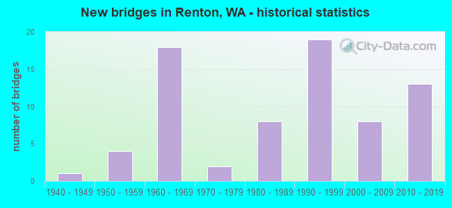
- New bridges - historical statistics
- 11940-1949
- 41950-1959
- 181960-1969
- 21970-1979
- 81980-1989
- 191990-1999
- 82000-2009
- 132010-2019
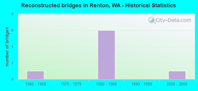
- Reconstructed bridges - Historical Statistics
- 11960-1969
- 01970-1979
- 61980-1989
- 01990-1999
- 12000-2009
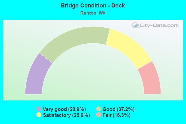
- Bridge Condition - Deck
- 20.9%Very good
- 37.2%Good
- 25.6%Satisfactory
- 16.3%Fair
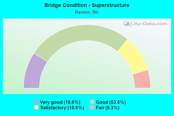
- Bridge Condition - Superstructure
- 18.6%Very good
- 53.5%Good
- 18.6%Satisfactory
- 9.3%Fair
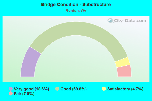
- Bridge Condition - Substructure
- 18.6%Very good
- 69.8%Good
- 4.7%Satisfactory
- 7.0%Fair
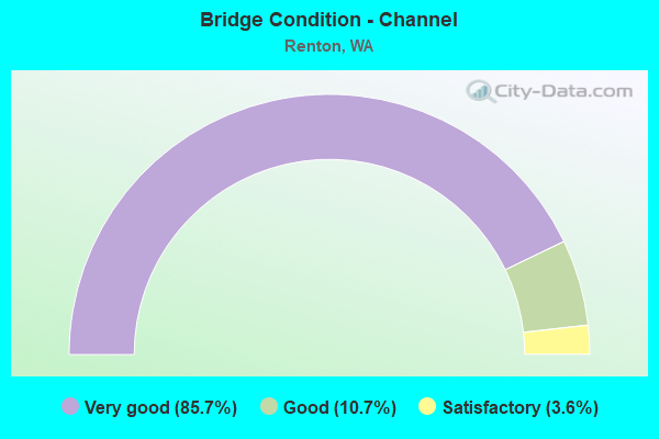
- Bridge Condition - Channel
- 85.7%Very good
- 10.7%Good
- 3.6%Satisfactory
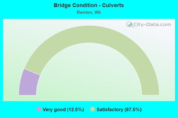
- Bridge Condition - Culverts
- 12.5%Very good
- 87.5%Satisfactory
Find on map >> Show street view
Structure Number: 85521, Location: 0.6 MI S OF I-405 (Lat: 47.458953, Lng: -122.223583), Route carried "on" structure: City street 1070, Year Built: 1981, Status: Open, Structure Length: 0.98m (3.22ft), Average Daily Traffic: 8,345 (year 2019), Truck Traffic: 13%, Average Future Daily Traffic: 12,200 (year 2039), Features Intersected: P9 CHANNEL/PANTHER CREEK, Facility Carried by Structure: LIND AVE SW
Minimum Vertical Clearance: 30+ m (98+ ft), Kilometerpoint: 0.001, Lanes on structure: 4, Owner: City or Municipal Highway Agency, Approaching Roadway Width: 13.4m (44.0ft), Material/Design: Steel, Design/Construction: Culvert, Number Of Spans In Main Unit: 2, Length of Maximum Span: 4.3m (14.1ft), Curb or Sidewalk Widths: Left: 1.7m (5.6ft), Right: 0.2m (0.7ft)
Condition: Channel: Very good, Culverts: Satisfactory, Operating Rating: 89.8 metric tons, Method Used To Determine Operating Rating: Load Factor (LF), Inventory Rating: 89.8 metric tons, Method Used To Determine Inventory Rating: Load Factor (LF), Structural Evaluation: Equal to present minimum criteria, Waterway Adequacy: Equal to present desirable criteria, Approach Roadway Alignment: Equal to present desirable criteria, Length Of Structure Improvement: 1.28m (4.20ft), Designated Inspection Frequency: Every 24 months, Inspection Date: June 2021, Bridge Improvement Cost: $1,042,000, Roadway Improvement Cost: $208,000, Total Project Cost: $2,083,000 ( Estimate for 2014)
Find on map >> Show street view
Structure Number: 85617, Location: 1.0 MI W OF SR-167 (Lat: 47.441197, Lng: -122.239044), Route carried "on" structure: City street 41020, Year Built: 1983, Status: Open, Structure Length: 0.88m (2.89ft), Average Daily Traffic: 27,713 (year 2019), Truck Traffic: 12%, Average Future Daily Traffic: 42,200 (year 2039), Features Intersected: SPRINGBROOK CREEK, Facility Carried by Structure: SW 43RD STREET
Minimum Vertical Clearance: 30+ m (98+ ft), Kilometerpoint: 0.001, Lanes on structure: 4, Base Highway Network: Yes, Owner: City or Municipal Highway Agency, Approaching Roadway Width: 13.4m (44.0ft), Skew: 4 degrees, Material/Design: Aluminum, Iron, Design/Construction: Culvert, Number Of Spans In Main Unit: 1, Length of Maximum Span: 8.5m (27.9ft), Curb or Sidewalk Widths: Left: 1.7m (5.6ft), Right: 1.7m (5.6ft)
Condition: Channel: Good, Culverts: Satisfactory, Operating Rating: 89.8 metric tons, Method Used To Determine Operating Rating: Load Factor (LF), Inventory Rating: 89.8 metric tons, Method Used To Determine Inventory Rating: Load Factor (LF), Structural Evaluation: Equal to present minimum criteria, Waterway Adequacy: Equal to present desirable criteria, Approach Roadway Alignment: Equal to present desirable criteria, Length Of Structure Improvement: 1.19m (3.90ft), Designated Inspection Frequency: Every 24 months, Inspection Date: June 2021, Bridge Improvement Cost: $967,000, Roadway Improvement Cost: $193,000, Total Project Cost: $1,934,000 ( Estimate for 2014)
Find on map >> Show street view
Structure Number: 85618, Location: 0.25 MI N OF SW 43 ST (Lat: 47.444028, Lng: -122.232806), Route carried "on" structure: City street 1070, Year Built: 1979, Status: Open, Structure Length: 1.01m (3.31ft), Average Daily Traffic: 9,325 (year 2019), Truck Traffic: 21%, Average Future Daily Traffic: 12,100 (year 2039), Features Intersected: SPRINGBROOK CREEK, Facility Carried by Structure: OAKESDALE AVE SW
Minimum Vertical Clearance: 30+ m (98+ ft), Kilometerpoint: 0.001, Lanes on structure: 5, Owner: City or Municipal Highway Agency, Approaching Roadway Width: 16.8m (55.1ft), Skew: 3 degrees, Material/Design: Steel, Design/Construction: Culvert, Number Of Spans In Main Unit: 4, Length of Maximum Span: 2.1m (6.9ft), Curb or Sidewalk Widths: Left: 2.0m (6.6ft), Right: 2.0m (6.6ft)
Condition: Channel: Very good, Culverts: Satisfactory, Operating Rating: 89.8 metric tons, Method Used To Determine Operating Rating: Load Factor (LF), Inventory Rating: 89.8 metric tons, Method Used To Determine Inventory Rating: Load Factor (LF), Structural Evaluation: Equal to present minimum criteria, Waterway Adequacy: Equal to present desirable criteria, Approach Roadway Alignment: Equal to present desirable criteria, Length Of Structure Improvement: 1.31m (4.30ft), Designated Inspection Frequency: Every 24 months, Inspection Date: June 2021, Bridge Improvement Cost: $1,273,000, Roadway Improvement Cost: $255,000, Total Project Cost: $2,546,000 ( Estimate for 2014)
Find on map >> Show street view
Structure Number: 85706, Location: 1.1 MI N OF I-405 (Lat: 47.473389, Lng: -122.238472), Route carried "on" structure: City street 1070, Year Built: 1987, Status: Open, Structure Length: 5.91m (19.39ft), Average Daily Traffic: 9,500 (year 2019), Truck Traffic: 11%, Average Future Daily Traffic: 13,000 (year 2041), Design Load: HS 20, Features Intersected: BLACK RIVER DRAIN, Facility Carried by Structure: OAKESDALE AVE SW
Minimum Vertical Clearance: 30+ m (98+ ft), Kilometerpoint: 0.001, Lanes on structure: 4, Owner: City or Municipal Highway Agency, Approaching Roadway Width: 14.6m (47.9ft), Skew: 2 degrees, Material/Design: Prestressed concrete continuous, Design/Construction: Stringer/Multi-beam, Number Of Spans In Main Unit: 1, Number Of Approach Spans: 2, Length of Maximum Span: 21.9m (71.9ft), Curb or Sidewalk Widths: Left: 1.8m (5.9ft), Right: 0.0m, Curb-To-Curb Width: 14.6m (47.9ft), Out-to-Out Width: 17.4m (57.1ft)
Condition: Deck: Satisfactory, Superstructure: Good, Substructure: Good, Channel: Very good, Operating Rating: 65.8 metric tons, Method Used To Determine Operating Rating: Load Factor (LF) rating reported by rating factor (RF) method using MS18 loading, Inventory Rating: 39.5 metric tons, Method Used To Determine Inventory Rating: Load Factor (LF) rating reported by rating factor (RF) method using MS18 loading, Structural Evaluation: Better than present minimum criteria, Deck Geometry: High priority of replacement, Waterway Adequacy: Equal to present desirable criteria, Approach Roadway Alignment: Equal to present desirable criteria, Length Of Structure Improvement: 5.91m (19.39ft), Designated Inspection Frequency: Every 24 months, Inspection Date: June 2021, Bridge Improvement Cost: $1,940,000, Roadway Improvement Cost: $388,000, Total Project Cost: $3,880,000 ( Estimate for 2014), Deck Structure Type: Concrete Cast-file-Place, Wearing Surface/Protective System: Wearing Surface: Monolithic Concrete, Deck Protection: Epoxy Coated Reinforcing
Find on map >> Show street view
Structure Number: 85843, Location: 0.1 MI E OF I-405 (Lat: 47.480939, Lng: -122.200575), Route carried "on" structure: City street 1169, Year Built: 1960, Status: Posted for load, Structure Length: 4.27m (14.01ft), Average Daily Traffic: 17,000 (year 2018), Truck Traffic: 7%, Average Future Daily Traffic: 24,000 (year 2038), Design Load: H 15, Features Intersected: CEDAR RIVER, Facility Carried by Structure: HOUSER WAY
Minimum Vertical Clearance: 30+ m (98+ ft), Kilometerpoint: 0.001, Lanes on structure: 2, Base Highway Network: Yes, Owner: City or Municipal Highway Agency, Approaching Roadway Width: 8.8m (28.9ft), Skew: 1 degrees, Material/Design: Steel, Design/Construction: Stringer/Multi-beam, Number Of Spans In Main Unit: 1, Number Of Approach Spans: 2, Length of Maximum Span: 33.5m (109.9ft), Curb or Sidewalk Widths: Left: 0.6m (2.0ft), Right: 0.6m (2.0ft), Curb-To-Curb Width: 8.6m (28.2ft), Out-to-Out Width: 9.6m (31.5ft)
Condition: Deck: Fair, Superstructure: Fair, Substructure: Fair, Channel: Very good, Operating Rating: 37.2 metric tons, Method Used To Determine Operating Rating: Load Factor (LF), Inventory Rating: 21.8 metric tons, Method Used To Determine Inventory Rating: Load Factor (LF), Structural Evaluation: Somewhat better than minimum adequacy, Deck Geometry: High priority of corrective action, Waterway Adequacy: Equal to present desirable criteria, Approach Roadway Alignment: Equal to present desirable criteria, Bridge Posting: Required (Relationship of Operating Rating to Maximum Legal Load: 20.0 - 29.9% below), Length Of Structure Improvement: 4.27m (14.01ft), Designated Inspection Frequency: Every 24 months, Inspection Date: September 2020, Bridge Improvement Cost: $868,000, Roadway Improvement Cost: $174,000, Total Project Cost: $1,736,000 ( Estimate for 2014), Deck Structure Type: Concrete Cast-file-Place, Wearing Surface/Protective System: Wearing Surface: Monolithic Concrete
Find on map >> Show street view
Structure Number: 85844, Location: 0.2 MI S OF I-405 (Lat: 47.465911, Lng: -122.232736), Route carried "on" structure: City street 1073, Year Built: 1991, Status: Open, Structure Length: 1.95m (6.40ft), Average Daily Traffic: 2,250 (year 2019), Truck Traffic: 23%, Average Future Daily Traffic: 3,000 (year 2039), Design Load: HS 20, Features Intersected: SPRINGBROOK CREEK, Facility Carried by Structure: SW 16TH STREET
Minimum Vertical Clearance: 30+ m (98+ ft), Kilometerpoint: 0.001, Lanes on structure: 3, Owner: City or Municipal Highway Agency, Approaching Roadway Width: 13.4m (44.0ft), Material/Design: Prestressed concrete, Design/Construction: Stringer/Multi-beam, Number Of Spans In Main Unit: 1, Length of Maximum Span: 18.9m (62.0ft), Curb or Sidewalk Widths: Left: 1.8m (5.9ft), Right: 1.8m (5.9ft), Curb-To-Curb Width: 13.4m (44.0ft), Out-to-Out Width: 17.7m (58.1ft)
Condition: Deck: Good, Superstructure: Good, Substructure: Good, Channel: Good, Operating Rating: 33.7 metric tons, Method Used To Determine Operating Rating: Load Factor (LF) rating reported by rating factor (RF) method using MS18 loading, Inventory Rating: 23.3 metric tons, Method Used To Determine Inventory Rating: Load Factor (LF) rating reported by rating factor (RF) method using MS18 loading, Structural Evaluation: Equal to present minimum criteria, Deck Geometry: Somewhat better than minimum adequacy, Waterway Adequacy: Equal to present desirable criteria, Approach Roadway Alignment: Equal to present desirable criteria, Length Of Structure Improvement: 2.26m (7.41ft), Designated Inspection Frequency: Every 24 months, Inspection Date: June 2021, Bridge Improvement Cost: $1,480,000, Roadway Improvement Cost: $296,000, Total Project Cost: $2,960,000 ( Estimate for 2014), Deck Structure Type: Other, Wearing Surface/Protective System: Wearing Surface: Bituminous, Deck Protection: Epoxy Coated Reinforcing
Find on map >> Show street view
Structure Number: 86035, Location: 0.2 MI E JCT SR-167 (Lat: 47.441111, Lng: -122.215186), Route carried "on" structure: City street 1274, Year Built: 1992, Status: Open, Structure Length: 1.07m (3.51ft), Average Daily Traffic: 34,442 (year 2019), Truck Traffic: 15%, Average Future Daily Traffic: 40,200 (year 2039), Design Load: H 20, Features Intersected: HOSPITAL ACCESS ROAD, Facility Carried by Structure: SOUTH 43RD STREET
Minimum Vertical Clearance: 30+ m (98+ ft), Kilometerpoint: 4.023, Lanes on structure: 6, Lanes under structure: 2, Base Highway Network: Yes, Owner: City or Municipal Highway Agency, Approaching Roadway Width: 24.4m (80.1ft), Material/Design: Concrete, Design/Construction: Culvert, Number Of Spans In Main Unit: 1, Length of Maximum Span: 10.1m (33.1ft), Curb or Sidewalk Widths: Left: 1.8m (5.9ft), Right: 1.8m (5.9ft), Curb-To-Curb Width: 24.4m (80.1ft), Out-to-Out Width: 32.0m (105.0ft)
Condition: Culverts: Satisfactory, Operating Rating: 59.9 metric tons, Method Used To Determine Operating Rating: Load Factor (LF), Inventory Rating: 36.3 metric tons, Method Used To Determine Inventory Rating: Load Factor (LF), Structural Evaluation: Equal to present minimum criteria, Deck Geometry: Somewhat better than minimum adequacy, Underclear: High priority of replacement, Approach Roadway Alignment: Equal to present desirable criteria, Length Of Structure Improvement: 1.37m (4.49ft), Designated Inspection Frequency: Every 24 months, Inspection Date: June 2021, Bridge Improvement Cost: $1,548,000, Roadway Improvement Cost: $310,000, Total Project Cost: $3,096,000 ( Estimate for 2014)
Find on map >> Show street view
Structure Number: 86322, Location: 0.2 MILES SW I-405 EXIT 7 (Lat: 47.529708, Lng: -122.201369), Route carried "on" structure: City street 1171, Year Built: 1996, Status: Open, Structure Length: 1.89m (6.20ft), Average Daily Traffic: 7,440 (year 2018), Truck Traffic: 16%, Average Future Daily Traffic: 9,000 (year 2038), Design Load: HS 25 or greater, Features Intersected: MAY CREEK, Facility Carried by Structure: LAKE WA BLVD
Minimum Vertical Clearance: 30+ m (98+ ft), Kilometerpoint: 0.001, Lanes on structure: 2, Owner: City or Municipal Highway Agency, Approaching Roadway Width: 9.8m (32.2ft), Material/Design: Prestressed concrete, Design/Construction: Slab, Number Of Spans In Main Unit: 1, Length of Maximum Span: 17.4m (57.1ft), Curb or Sidewalk Widths: Left: 1.5m (4.9ft), Right: 1.5m (4.9ft), Curb-To-Curb Width: 9.8m (32.2ft), Out-to-Out Width: 13.4m (44.0ft)
Condition: Deck: Good, Superstructure: Good, Substructure: Good, Channel: Very good, Operating Rating: 82.5 metric tons, Method Used To Determine Operating Rating: Load Factor (LF), Inventory Rating: 49.0 metric tons, Method Used To Determine Inventory Rating: Load Factor (LF), Structural Evaluation: Better than present minimum criteria, Deck Geometry: Meets minimum limits, Waterway Adequacy: Better than present minimum criteria, Approach Roadway Alignment: Equal to present desirable criteria, Length Of Structure Improvement: 2.19m (7.19ft), Designated Inspection Frequency: Every 24 months, Inspection Date: June 2021, Bridge Improvement Cost: $1,094,000, Roadway Improvement Cost: $219,000, Total Project Cost: $2,189,000 ( Estimate for 2014), Deck Structure Type: Concrete Cast-file-Place, Wearing Surface/Protective System: Wearing Surface: Monolithic Concrete, Deck Protection: Epoxy Coated Reinforcing
Find on map >> Show street view
Structure Number: 87059, Location: 0.5 M. WEST OF LIND AVE. (Lat: 47.465028, Lng: -122.232333), Route carried "on" structure: City street 1070, Year Built: 1998, Status: Open, Structure Length: 4.18m (13.71ft), Average Daily Traffic: 7,866 (year 2019), Truck Traffic: 20%, Average Future Daily Traffic: 12,000 (year 2038), Design Load: HS 25 or greater, Features Intersected: SPRINGBROOK CREEK, Facility Carried by Structure: OAKESDALE AVE SW
Minimum Vertical Clearance: 30+ m (98+ ft), Kilometerpoint: 0.001, Lanes on structure: 5, Owner: City or Municipal Highway Agency, Approaching Roadway Width: 20.4m (66.9ft), Skew: 4 degrees, Material/Design: Prestressed concrete, Design/Construction: Stringer/Multi-beam, Number Of Spans In Main Unit: 1, Length of Maximum Span: 39.9m (130.9ft), Curb or Sidewalk Widths: Left: 2.0m (6.6ft), Right: 2.0m (6.6ft), Curb-To-Curb Width: 20.1m (65.9ft), Out-to-Out Width: 25.0m (82.0ft)
Condition: Deck: Good, Superstructure: Good, Substructure: Good, Channel: Very good, Operating Rating: 49.0 metric tons, Method Used To Determine Operating Rating: Load and Resistance Factor (LRFR), Inventory Rating: 29.9 metric tons, Method Used To Determine Inventory Rating: Load and Resistance Factor (LRFR), Structural Evaluation: Better than present minimum criteria, Deck Geometry: Somewhat better than minimum adequacy, Waterway Adequacy: Equal to present desirable criteria, Approach Roadway Alignment: Equal to present desirable criteria, Length Of Structure Improvement: 4.48m (14.70ft), Designated Inspection Frequency: Every 24 months, Inspection Date: June 2021, Bridge Improvement Cost: $4,351,000, Roadway Improvement Cost: $870,000, Total Project Cost: $8,702,000 ( Estimate for 2014), Deck Structure Type: Concrete Cast-file-Place, Wearing Surface/Protective System: Wearing Surface: Monolithic Concrete, Deck Protection: Epoxy Coated Reinforcing
Find on map >> Show street view
Structure Number: 87796, Location: 0.2 MI WEST LIND AVE (Lat: 47.449278, Lng: -122.227514), Route carried "on" structure: City street 1070, Year Built: 2007, Status: Open, Structure Length: 0.91m (2.99ft), Average Daily Traffic: 1,900 (year 2019), Truck Traffic: 29%, Average Future Daily Traffic: 2,900 (year 2039), Design Load: HS 25 or greater, Features Intersected: SPRINGBROOK CREEK, Facility Carried by Structure: SW 34TH STREET
Minimum Vertical Clearance: 30+ m (98+ ft), Kilometerpoint: 0.001, Lanes on structure: 4, Owner: City or Municipal Highway Agency, Approaching Roadway Width: 13.4m (44.0ft), Material/Design: Concrete, Design/Construction: Culvert, Number Of Spans In Main Unit: 1, Length of Maximum Span: 9.1m (29.9ft), Curb or Sidewalk Widths: Left: 1.8m (5.9ft), Right: 4.0m (13.1ft), Curb-To-Curb Width: 13.4m (44.0ft), Out-to-Out Width: 19.9m (65.3ft)
Condition: Channel: Very good, Culverts: Satisfactory, Operating Rating: 56.7 metric tons, Method Used To Determine Operating Rating: Load and Resistance Factor Rating (LRFR) rating reported by rating factor(RF) method using HL-93 loadings, Inventory Rating: 43.7 metric tons, Method Used To Determine Inventory Rating: Load and Resistance Factor Rating (LRFR) rating reported by rating factor(RF) method using HL-93 loadings, Structural Evaluation: Equal to present minimum criteria, Deck Geometry: High priority of replacement, Waterway Adequacy: Equal to present desirable criteria, Approach Roadway Alignment: Equal to present desirable criteria, Length Of Structure Improvement: 0.91m (2.99ft), Designated Inspection Frequency: Every 24 months, Inspection Date: June 2021, Bridge Improvement Cost: $276,000, Roadway Improvement Cost: $55,000, Total Project Cost: $552,000 ( Estimate for 2014), Wearing Surface/Protective System: Wearing Surface: Monolithic Concrete, Deck Protection: Epoxy Coated Reinforcing
Find on map >> Show street view
Structure Number: 88154, Location: 0.2 MI W OF I-405 (Lat: 47.516111, Lng: -122.203394), Route carried "on" structure: City street 1173, Year Built: 2000, Status: Open, Structure Length: 0.70m (2.30ft), Average Daily Traffic: 292 (year 2018), Truck Traffic: 5%, Average Future Daily Traffic: 400 (year 2038), Design Load: HS 20, Features Intersected: KENNYDALE CREEK, Facility Carried by Structure: N 27TH PLACE
Minimum Vertical Clearance: 30+ m (98+ ft), Kilometerpoint: 0.001, Lanes on structure: 2, Owner: City or Municipal Highway Agency, Approaching Roadway Width: 9.8m (32.2ft), Skew: 1 degrees, Material/Design: Concrete, Design/Construction: Culvert, Number Of Spans In Main Unit: 1, Length of Maximum Span: 6.1m (20.0ft)
Condition: Channel: Very good, Culverts: Satisfactory, Operating Rating: 59.3 metric tons, Method Used To Determine Operating Rating: Load Factor (LF) rating reported by rating factor (RF) method using MS18 loading, Inventory Rating: 36.0 metric tons, Method Used To Determine Inventory Rating: Load Factor (LF) rating reported by rating factor (RF) method using MS18 loading, Structural Evaluation: Equal to present minimum criteria, Waterway Adequacy: Equal to present desirable criteria, Approach Roadway Alignment: Equal to present desirable criteria, Length Of Structure Improvement: 1.01m (3.31ft), Designated Inspection Frequency: Every 24 months, Inspection Date: June 2021, Bridge Improvement Cost: $502,000, Roadway Improvement Cost: $100,000, Total Project Cost: $1,003,000 ( Estimate for 2014)
Find on map >> Show street view
Structure Number: 88155, Location: 0.2 MI W OF I-405 (Lat: 47.528511, Lng: -122.204156), Route carried "on" structure: City street 1070, Year Built: 2007, Status: Open, Structure Length: 2.62m (8.60ft), Average Daily Traffic: 165 (year 2018), Truck Traffic: 20%, Average Future Daily Traffic: 350 (year 2038), Design Load: HL 93, Features Intersected: MAY CREEK, Facility Carried by Structure: N 40TH PLACE
Minimum Vertical Clearance: 30+ m (98+ ft), Kilometerpoint: 0.001, Lanes on structure: 2, Owner: City or Municipal Highway Agency, Approaching Roadway Width: 8.5m (27.9ft), Material/Design: Prestressed concrete, Design/Construction: Tee Beam, Number Of Spans In Main Unit: 1, Length of Maximum Span: 24.7m (81.0ft), Curb or Sidewalk Widths: Left: 1.7m (5.6ft), Right: 1.7m (5.6ft), Curb-To-Curb Width: 8.5m (27.9ft), Out-to-Out Width: 12.3m (40.4ft)
Condition: Deck: Very good, Superstructure: Good, Substructure: Good, Channel: Very good, Operating Rating: 84.4 metric tons, Method Used To Determine Operating Rating: Load and Resistance Factor (LRFR), Inventory Rating: 50.8 metric tons, Method Used To Determine Inventory Rating: Load and Resistance Factor (LRFR), Structural Evaluation: Better than present minimum criteria, Deck Geometry: Equal to present minimum criteria, Waterway Adequacy: Equal to present desirable criteria, Approach Roadway Alignment: Equal to present desirable criteria, Length Of Structure Improvement: 2.93m (9.61ft), Designated Inspection Frequency: Every 24 months, Inspection Date: June 2021, Bridge Improvement Cost: $1,459,000, Roadway Improvement Cost: $292,000, Total Project Cost: $2,918,000 ( Estimate for 2014), Deck Structure Type: Other, Wearing Surface/Protective System: Wearing Surface: Bituminous
Find on map >> Show street view
Structure Number: 88721, Location: 0.3 MI E OF I-405 (Lat: 47.519039, Lng: -122.189208), Route carried "on" structure: City street 1070, Year Built: 2014, Status: Open, Structure Length: 1.89m (6.20ft), Average Daily Traffic: 50 (year 2018), Truck Traffic: 16%, Average Future Daily Traffic: 99 (year 2038), Design Load: HL 93, Features Intersected: MAY CREEK, Facility Carried by Structure: NE 31ST STREET
Minimum Vertical Clearance: 30+ m (98+ ft), Kilometerpoint: 0.001, Lanes on structure: 2, Owner: City or Municipal Highway Agency, Approaching Roadway Width: 7.0m (23.0ft), Material/Design: Prestressed concrete, Design/Construction: Slab, Number Of Spans In Main Unit: 1, Length of Maximum Span: 17.7m (58.1ft), Curb-To-Curb Width: 6.3m (20.7ft), Out-to-Out Width: 6.4m (21.0ft)
Condition: Deck: Very good, Superstructure: Very good, Substructure: Very good, Channel: Good, Operating Rating: 60.9 metric tons, Method Used To Determine Operating Rating: Load and Resistance Factor Rating (LRFR) rating reported by rating factor(RF) method using HL-93 loadings, Inventory Rating: 47.0 metric tons, Method Used To Determine Inventory Rating: Load and Resistance Factor Rating (LRFR) rating reported by rating factor(RF) method using HL-93 loadings, Structural Evaluation: Equal to present desirable criteria, Deck Geometry: Somewhat better than minimum adequacy, Waterway Adequacy: Equal to present desirable criteria, Approach Roadway Alignment: Equal to present minimum criteria, Length Of Structure Improvement: 2.19m (7.19ft), Designated Inspection Frequency: Every 24 months, Inspection Date: June 2021, Bridge Improvement Cost: $1,094,000, Roadway Improvement Cost: $219,000, Total Project Cost: $2,189,000 ( Estimate for 2014), Deck Structure Type: Other, Wearing Surface/Protective System: Wearing Surface: Bituminous, Membrane: Preformed Fabric, Deck Protection: Epoxy Coated Reinforcing
Find on map >> Show street view
Structure Number: 89028, Location: 0.5 MI E OF I-405 (Lat: 47.519028, Lng: -122.191539), Route carried "on" structure: City street 1070, Year Built: 2018, Status: Open, Structure Length: 2.41m (7.91ft), Average Daily Traffic: 30 (year 2018), Truck Traffic: 1%, Average Future Daily Traffic: 40 (year 2038), Design Load: HL 93, Features Intersected: MAY CREEK, Facility Carried by Structure: NE 31ST STREE
Minimum Vertical Clearance: 30+ m (98+ ft), Kilometerpoint: 0.001, Lanes on structure: 2, Owner: City or Municipal Highway Agency, Approaching Roadway Width: 7.9m (25.9ft), Material/Design: Concrete, Design/Construction: Slab, Number Of Spans In Main Unit: 1, Length of Maximum Span: 22.9m (75.1ft), Curb-To-Curb Width: 6.2m (20.3ft), Out-to-Out Width: 6.3m (20.7ft)
Condition: Deck: Very good, Superstructure: Very good, Substructure: Very good, Channel: Very good, Operating Rating: 53.1 metric tons, Method Used To Determine Operating Rating: Load and Resistance Factor Rating (LRFR) rating reported by rating factor(RF) method using HL-93 loadings, Inventory Rating: 37.3 metric tons, Method Used To Determine Inventory Rating: Load and Resistance Factor Rating (LRFR) rating reported by rating factor(RF) method using HL-93 loadings, Structural Evaluation: Equal to present desirable criteria, Deck Geometry: Somewhat better than minimum adequacy, Waterway Adequacy: Equal to present desirable criteria, Approach Roadway Alignment: Equal to present desirable criteria, Length Of Structure Improvement: 2.41m (7.91ft), Designated Inspection Frequency: Every 24 months, Inspection Date: June 2021, Bridge Improvement Cost: $442,000, Roadway Improvement Cost: $88,000, Total Project Cost: $885,000 ( Estimate for 2014), Deck Structure Type: Concrete Precast Panels, Wearing Surface/Protective System: Wearing Surface: Bituminous, Membrane: Preformed Fabric, Deck Protection: Epoxy Coated Reinforcing
Find on map >> Show street view
Structure Number: 89029, Location: 3.0 MI E OF SR 167 (Lat: 47.435914, Lng: -122.207303), Route carried "on" structure: City street 1169, Year Built: 2017, Status: Open, Structure Length: 0.64m (2.10ft), Average Daily Traffic: 75 (year 2018), Truck Traffic: 1%, Average Future Daily Traffic: 150 (year 2038), Design Load: HL 93, Features Intersected: WETLAND, Facility Carried by Structure: SMITHERS AVE S
Minimum Vertical Clearance: 30+ m (98+ ft), Kilometerpoint: 0.001, Lanes on structure: 2, Owner: City or Municipal Highway Agency, Approaching Roadway Width: 6.7m (22.0ft), Material/Design: Steel, Design/Construction: Culvert, Number Of Spans In Main Unit: 1, Length of Maximum Span: 6.4m (21.0ft)
Condition: Channel: Very good, Culverts: Very good, Operating Rating: 96.9 metric tons, Method Used To Determine Operating Rating: Load and Resistance Factor Rating (LRFR) rating reported by rating factor(RF) method using HL-93 loadings, Inventory Rating: 96.9 metric tons, Method Used To Determine Inventory Rating: Load and Resistance Factor Rating (LRFR) rating reported by rating factor(RF) method using HL-93 loadings, Structural Evaluation: Equal to present desirable criteria, Waterway Adequacy: Equal to present desirable criteria, Approach Roadway Alignment: Equal to present desirable criteria, Length Of Structure Improvement: 0.64m (2.10ft), Designated Inspection Frequency: Every 24 months, Inspection Date: October 2020, Bridge Improvement Cost: $101,000, Roadway Improvement Cost: $20,000, Total Project Cost: $202,000 ( Estimate for 2014)
Find on map >> Show street view
Structure Number: 6912B, Location: 1.1 E JCT SR 515 (Lat: 47.490056, Lng: -122.192472), Route carried "under" structure: City street , Year Built: 1963, Structure Length: 0. m, Average Daily Traffic: 15,456 (year 2019), Truck Traffic: 4%, Features Intersected: SUNSET BLVD (OLD SR 900), Facility Carried by Structure: I-405
Minimum Vertical Clearance: 5.69m (18.67ft), Kilometerpoint: 0.080, Lanes on structure: 6, Lanes under structure: 3, Material/Design: Prestressed concrete, Design/Construction: Stringer/Multi-beam, Length of Maximum Span: 24.4m (80.1ft)
Find on map >> Show street view
Structure Number: 7085B, Location: 3.8 N JCT SR 516 (Lat: 47.441194, Lng: -122.218000), Route carried "under" structure: State highway 167, Year Built: 1964, Structure Length: 0. m, Average Daily Traffic: 108,195 (year 2019), Truck Traffic: 7%, Features Intersected: SR 167, Facility Carried by Structure: S 180TH ST
Minimum Vertical Clearance: 6.86m (22.51ft), Kilometerpoint: 39.300, Lanes on structure: 5, Lanes under structure: 7, Material/Design: Prestressed concrete, Design/Construction: Stringer/Multi-beam, Length of Maximum Span: 20.1m (65.9ft)
Find on map >> Show street view
Structure Number: 7376A, Location: 5.7 N JCT SR 516 (Lat: 47.467839, Lng: -122.218353), Route carried "under" structure: State highway 167, Year Built: 1964, Structure Length: 0. m, Average Daily Traffic: 93,138 (year 2019), Truck Traffic: 7%, Features Intersected: SR 167, Facility Carried by Structure: I-405
Minimum Vertical Clearance: 5.03m (16.50ft), Kilometerpoint: 42.294, Lanes on structure: 9, Lanes under structure: 6, Material/Design: Prestressed concrete, Design/Construction: Stringer/Multi-beam, Length of Maximum Span: 17.1m (56.1ft)
Find on map >> Show street view
Structure Number: 7376C, Location: 6.9 N JCT SR 516 (Lat: 47.468889, Lng: -122.208056), Route carried "under" structure: State highway 515, Year Built: 1964, Structure Length: 0. m, Average Daily Traffic: 48,123 (year 2019), Truck Traffic: 2%, Features Intersected: BURNETT ST TALBOT RD, Facility Carried by Structure: I-405
Minimum Vertical Clearance: 6.60m (21.65ft), Kilometerpoint: 11.153, Lanes on structure: 6, Lanes under structure: 5, Material/Design: Prestressed concrete, Design/Construction: Stringer/Multi-beam, Length of Maximum Span: 30.8m (101.0ft)
Find on map >> Show street view
Structure Number: 7623A, Location: 2.0 N JCT SR 900 (Lat: 47.532167, Lng: -122.197889), Route carried "under" structure: Interstate 405, Year Built: 1965, Structure Length: 0. m, Average Daily Traffic: 144,356 (year 2019), Truck Traffic: 6%, Features Intersected: I-405, Facility Carried by Structure: NE 44TH ST
Minimum Vertical Clearance: 6.02m (19.75ft), Kilometerpoint: 12.022, Lanes on structure: 2, Lanes under structure: 7, Material/Design: Prestressed concrete, Design/Construction: Stringer/Multi-beam, Length of Maximum Span: 21.3m (69.9ft)
Find on map >> Show street view
Structure Number: 7828A, Location: JCT I-405 (Lat: 47.502392, Lng: -122.196525), Route carried "under" structure: State highway 900, Year Built: 1966, Structure Length: 0. m, Average Daily Traffic: 30,232 (year 2019), Truck Traffic: 4%, Features Intersected: SR 900 / N PARK DR, Facility Carried by Structure: I-405
Minimum Vertical Clearance: 5.03m (16.50ft), Kilometerpoint: 20.133, Lanes on structure: 3, Lanes under structure: 6, Material/Design: Prestressed concrete, Design/Construction: Stringer/Multi-beam, Length of Maximum Span: 32.0m (105.0ft)
Find on map >> Show street view
Structure Number: 7828B, Location: JCT I-405 (Lat: 47.502528, Lng: -122.196806), Route carried "under" structure: State highway 900, Year Built: 1966, Structure Length: 0. m, Average Daily Traffic: 30,232 (year 2019), Truck Traffic: 4%, Features Intersected: SR 900 / N PARK DR, Facility Carried by Structure: I-405
Minimum Vertical Clearance: 6.27m (20.57ft), Kilometerpoint: 20.117, Lanes on structure: 3, Lanes under structure: 6, Material/Design: Prestressed concrete, Design/Construction: Stringer/Multi-beam, Length of Maximum Span: 32.0m (105.0ft)
Find on map >> Show street view
Structure Number: 8054A, Location: 0.3 E JCT I-405 (Lat: 47.501028, Lng: -122.191000), Route carried "under" structure: State highway 900, Year Built: 1967, Structure Length: 0. m, Average Daily Traffic: 27,164 (year 2019), Truck Traffic: 4%, Features Intersected: SR 900, Facility Carried by Structure: ABERDEEN AVE NE
Minimum Vertical Clearance: 7.44m (24.41ft), Kilometerpoint: 20.616, Lanes on structure: 2, Lanes under structure: 4, Material/Design: Concrete continuous, Design/Construction: Box Beam or Girders - Multiple, Length of Maximum Span: 29.3m (96.1ft)
Find on map >> Show street view
Structure Number: 11976A, Location: 1.1 N JCT SR 900 (Lat: 47.518528, Lng: -122.198833), Route carried "under" structure: Interstate 405, Year Built: 1981, Structure Length: 0. m, Average Daily Traffic: 143,117 (year 2019), Truck Traffic: 6%, Features Intersected: SR 405, Facility Carried by Structure: NE 30TH ST
Minimum Vertical Clearance: 6.81m (22.34ft), Kilometerpoint: 10.477, Lanes on structure: 3, Lanes under structure: 6, Material/Design: Prestressed concrete continuous, Design/Construction: Tee Beam, Length of Maximum Span: 22.9m (75.1ft)
Find on map >> Show street view
Structure Number: 12177A, Location: 6.2 N JCT SR 516 (Lat: 47.459078, Lng: -122.207103), Route carried "under" structure: State highway 515, Year Built: 1983, Structure Length: 0. m, Average Daily Traffic: 24,748 (year 2019), Truck Traffic: 2%, Features Intersected: SR 515, Facility Carried by Structure: TALBOT HILL PED.
Minimum Vertical Clearance: 5.05m (16.57ft), Kilometerpoint: 10.042, Lanes under structure: 4, Material/Design: Concrete, Design/Construction: Tee Beam, Length of Maximum Span: 24.4m (80.1ft)
Find on map >> Show street view
Structure Number: 13354D, Location: 1.1 N JCT SR 181 (Lat: 47.467867, Lng: -122.223347), Route carried "under" structure: Interstate 405, Year Built: 1990, Structure Length: 0. m, Average Daily Traffic: 172,188 (year 2019), Truck Traffic: 6%, Features Intersected: I-405, Facility Carried by Structure: LIND AVE (88TH AVE
Minimum Vertical Clearance: 5.08m (16.67ft), Kilometerpoint: 3.315, Lanes on structure: 4, Lanes under structure: 8, Material/Design: Prestressed concrete continuous, Design/Construction: Stringer/Multi-beam, Length of Maximum Span: 33.2m (108.9ft)
Find on map >> Show street view
Structure Number: 14052D, Location: 1.3 N JCT SR 167 (Lat: 47.480139, Lng: -122.201111), Route carried "under" structure: Interstate 405, Year Built: 1994, Structure Length: 0. m, Average Daily Traffic: 175,455 (year 2019), Truck Traffic: 6%, Features Intersected: SR 405, Facility Carried by Structure: RENTON AVE S
Minimum Vertical Clearance: 5.82m (19.09ft), Kilometerpoint: 5.874, Lanes on structure: 2, Lanes under structure: 7, Material/Design: Concrete continuous, Design/Construction: Box Beam or Girders - Multiple, Length of Maximum Span: 23.5m (77.1ft)
Find on map >> Show street view
Structure Number: 14052E, Location: 1.2 N JCT SR 167 (Lat: 47.479250, Lng: -122.202417), Route carried "under" structure: Interstate 405, Year Built: 1993, Structure Length: 0. m, Average Daily Traffic: 175,455 (year 2019), Truck Traffic: 6%, Features Intersected: I-405, Facility Carried by Structure: CEDAR AVE S
Minimum Vertical Clearance: 6.71m (22.01ft), Kilometerpoint: 5.745, Lanes on structure: 2, Lanes under structure: 6, Material/Design: Concrete continuous, Design/Construction: Box Beam or Girders - Multiple, Length of Maximum Span: 23.2m (76.1ft)
Find on map >> Show street view
Structure Number: 14052F, Location: 11.1 N JCT SR 18 (Lat: 47.483917, Lng: -122.196778), Route carried "under" structure: State highway 169, Year Built: 1994, Structure Length: 0. m, Average Daily Traffic: 43,398 (year 2019), Truck Traffic: 6%, Features Intersected: SR 169, Facility Carried by Structure: I-405
Minimum Vertical Clearance: 5.08m (16.67ft), Kilometerpoint: 40.604, Lanes on structure: 7, Lanes under structure: 7, Material/Design: Prestressed concrete, Design/Construction: Stringer/Multi-beam, Length of Maximum Span: 35.1m (115.2ft)
Find on map >> Show street view
Structure Number: 14756A, Location: JCT I-405 (Lat: 47.502278, Lng: -122.196250), Route carried "under" structure: State highway 900, Year Built: 1997, Structure Length: 0. m, Average Daily Traffic: 30,232 (year 2019), Truck Traffic: 4%, Features Intersected: SR 900, Facility Carried by Structure: E-N RAMP
Minimum Vertical Clearance: 5.77m (18.93ft), Kilometerpoint: 20.149, Lanes on structure: 2, Lanes under structure: 6, Material/Design: Prestressed concrete continuous, Design/Construction: Stringer/Multi-beam, Length of Maximum Span: 33.5m (109.9ft)
Find on map >> Show street view
Structure Number: 16145A, Location: JCT I-405 (Lat: 47.468417, Lng: -122.216333), Route carried "under" structure: State highway 167, Year Built: 2002, Structure Length: 0. m, Average Daily Traffic: 93,138 (year 2019), Truck Traffic: 7%, Features Intersected: SR 167, RAMP, Facility Carried by Structure: S-S RAMP
Minimum Vertical Clearance: 6.45m (21.16ft), Kilometerpoint: 42.342, Lanes on structure: 1, Lanes under structure: 4, Material/Design: Steel continuous, Design/Construction: Stringer/Multi-beam, Length of Maximum Span: 48.2m (158.1ft)
Find on map >> Show street view
Structure Number: 17624A, Location: 0.6 N JCT SR 167 (Lat: 47.470306, Lng: -122.206389), Route carried "under" structure: Interstate 405, Year Built: 2010, Structure Length: 0. m, Average Daily Traffic: 94,517 (year 2019), Truck Traffic: 6%, Features Intersected: I-405, Facility Carried by Structure: BENSON ROAD
Minimum Vertical Clearance: 6.20m (20.34ft), Kilometerpoint: 4.635, Lanes on structure: 2, Lanes under structure: 11, Material/Design: Prestressed concrete continuous, Design/Construction: Stringer/Multi-beam, Length of Maximum Span: 63.1m (207.0ft)
Find on map >> Show street view
Structure Number: 18811A, Location: 6.9 N JCT SR 516 (Lat: 47.468819, Lng: -122.208417), Route carried "under" structure: State highway 515, Year Built: 2017, Structure Length: 0. m, Average Daily Traffic: 48,123 (year 2019), Truck Traffic: 2%, Features Intersected: BURNETT ST TALBOT RD, Facility Carried by Structure: I-405
Minimum Vertical Clearance: 6.60m (21.65ft), Kilometerpoint: 11.153, Lanes on structure: 1, Lanes under structure: 6, Material/Design: Concrete, Design/Construction: Stringer/Multi-beam, Length of Maximum Span: 52.1m (170.9ft)
Find on map >> Show street view
Structure Number: 18811B, Location: 6.9 N JCT SR 516 (Lat: 47.468983, Lng: -122.208417), Route carried "under" structure: State highway 515, Year Built: 2017, Structure Length: 0. m, Average Daily Traffic: 48,123 (year 2019), Truck Traffic: 2%, Features Intersected: BURNETT ST TALBOT RD, Facility Carried by Structure: I-405
Minimum Vertical Clearance: 6.60m (21.65ft), Kilometerpoint: 11.153, Lanes on structure: 1, Lanes under structure: 6, Material/Design: Concrete, Design/Construction: Stringer/Multi-beam, Length of Maximum Span: 51.8m (169.9ft)
Find on map >> Show street view
Structure Number: 18811C, Location: 1.5 N JCT SR 181 (Lat: 47.464917, Lng: -122.218028), Route carried "under" structure: Interstate 405, Year Built: 2018, Structure Length: 0. m, Average Daily Traffic: 47,259 (year 2019), Truck Traffic: 6%, Features Intersected: I-405 NB, SR 167 NB, Facility Carried by Structure: SR 167 FLYOVER
Minimum Vertical Clearance: 5.87m (19.26ft), Kilometerpoint: 3.943, Lanes on structure: 2, Lanes under structure: 2, Material/Design: Prestressed concrete, Design/Construction: Stringer/Multi-beam, Length of Maximum Span: 53.0m (173.9ft)
Find on map >> Show street view
Structure Number: 18811C, Location: 4.5 N JCT SR 516 (Lat: 47.464917, Lng: -122.218028), Route carried "under" structure: State highway 167, Year Built: 2018, Structure Length: 0. m, Average Daily Traffic: 64,354 (year 2019), Truck Traffic: 7%, Features Intersected: I-405 NB, SR 167 NB
Minimum Vertical Clearance: 6.50m (21.33ft), Kilometerpoint: 42.084, Lanes on structure: 2, Lanes under structure: 2, Material/Design: Prestressed concrete, Design/Construction: Stringer/Multi-beam, Length of Maximum Span: 53.0m (173.9ft)
Find on map >> Show street view
Structure Number: 200421, Location: 0.6 N JCT I-405 (Lat: 47.476103, Lng: -122.215092), Route carried "under" structure: State highway 167, Year Built: 2007, Structure Length: 0. m, Average Daily Traffic: 37,710 (year 2019), Truck Traffic: 4%, Features Intersected: SR 167, Facility Carried by Structure: RAILROAD
Minimum Vertical Clearance: 5.66m (18.57ft), Kilometerpoint: 43.291, Lanes under structure: 5, Material/Design: Steel, Design/Construction: Stringer/Multi-beam, Length of Maximum Span: 34.4m (112.9ft)