Bridge Statistics for Rock Springs, Wyoming (WY)
Condition, Traffic, Stress, Structural Evaluation, Project Costs
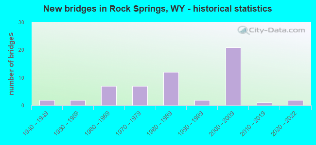
- New bridges - historical statistics
- 21940-1949
- 21950-1959
- 71960-1969
- 71970-1979
- 121980-1989
- 21990-1999
- 212000-2009
- 12010-2019
- 22020-2022
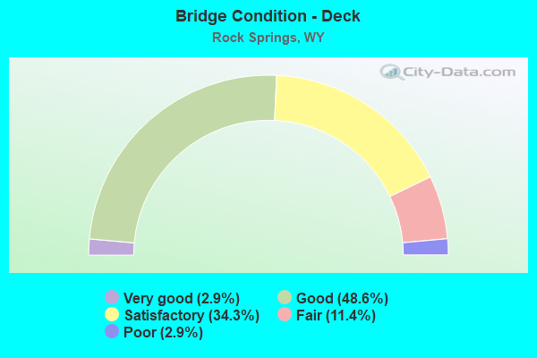
- Bridge Condition - Deck
- 2.9%Very good
- 48.6%Good
- 34.3%Satisfactory
- 11.4%Fair
- 2.9%Poor

- Bridge Condition - Superstructure
- 37.1%Very good
- 40.0%Good
- 14.3%Satisfactory
- 2.9%Fair
- 5.7%Serious
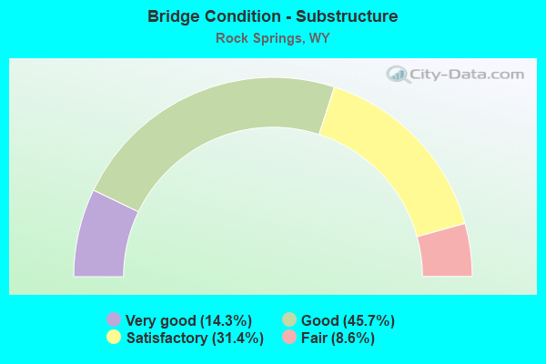
- Bridge Condition - Substructure
- 14.3%Very good
- 45.7%Good
- 31.4%Satisfactory
- 8.6%Fair
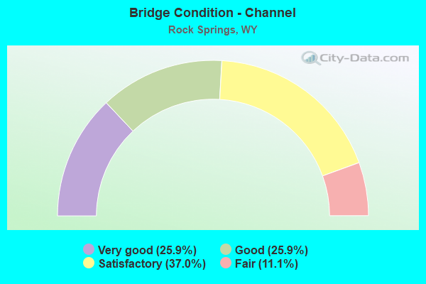
- Bridge Condition - Channel
- 25.9%Very good
- 25.9%Good
- 37.0%Satisfactory
- 11.1%Fair
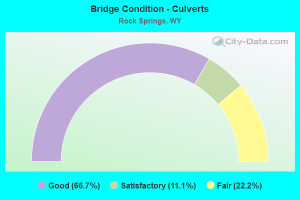
- Bridge Condition - Culverts
- 66.7%Good
- 11.1%Satisfactory
- 22.2%Fair
Find on map >> Show street view
Structure Number: MIE, Location: 2 Miles W Of Rock Springs (Lat: 41.567728, Lng: -109.273556), Route carried "on" structure: City street , Year Built: 1985, Status: Open, Structure Length: 3.75m (12.30ft), Average Daily Traffic: 3,234 (year 2021), Truck Traffic: 4%, Average Future Daily Traffic: 4,528 (year 2041), Design Load: HS 25 or greater, Features Intersected: Bitter Creek, Facility Carried by Structure: Interchange Road
Minimum Vertical Clearance: 30+ m (98+ ft), Kilometerpoint: 0.621, Lanes on structure: 2, Owner: Town or Township Highway Agency, Approaching Roadway Width: 7.6m (24.9ft), Material/Design: Prestressed concrete, Design/Construction: Box Beam or Girders - Multiple, Number Of Spans In Main Unit: 3, Length of Maximum Span: 18.3m (60.0ft), Curb-To-Curb Width: 9.1m (29.9ft), Out-to-Out Width: 9.8m (32.2ft)
Condition: Deck: Fair, Superstructure: Satisfactory, Substructure: Satisfactory, Channel: Satisfactory, Operating Rating: 81.6 metric tons, Method Used To Determine Operating Rating: Field evaluation and documented engineering judgment, Inventory Rating: 49.0 metric tons, Method Used To Determine Inventory Rating: Field evaluation and documented engineering judgment, Structural Evaluation: Equal to present minimum criteria, Deck Geometry: Meets minimum limits, Waterway Adequacy: Equal to present desirable criteria, Approach Roadway Alignment: Equal to present minimum criteria, Designated Inspection Frequency: Every 24 months, Inspection Date: August 2020, Deck Structure Type: Concrete Precast Panels, Wearing Surface/Protective System: Wearing Surface: Integral Concrete
Find on map >> Show street view
Structure Number: NEB, Location: 4 mi east of Rock Springs (Lat: 41.613203, Lng: -109.127486), Route carried "on" structure: Interstate 80, Year Built: 2021, Status: Open, Structure Length: 4.42m (14.50ft), Average Daily Traffic: 7,372 (year 2021), Truck Traffic: 50%, Average Future Daily Traffic: 10,321 (year 2041), Design Load: HL 93, Features Intersected: Baxter Road
Minimum Vertical Clearance: 30.48m (100.00ft), Kilometerpoint: 178.656, Lanes on structure: 2, Lanes under structure: 2, Base Highway Network: Yes (Inventory Route: ML8, Subroute: 1), Owner: State Highway Agency, Approaching Roadway Width: 11.6m (38.1ft), Skew: 3 degrees, Material/Design: Steel, Design/Construction: Stringer/Multi-beam, Number Of Spans In Main Unit: 1, Length of Maximum Span: 0.0m, Curb-To-Curb Width: 11.6m (38.1ft), Out-to-Out Width: 12.4m (40.7ft)
Condition: Deck: Very good, Superstructure: Very good, Substructure: Very good, Operating Rating: 69.0 metric tons, Method Used To Determine Operating Rating: Load and Resistance Factor Rating (LRFR) rating reported by rating factor(RF) method using HL-93 loadings, Inventory Rating: 53.1 metric tons, Method Used To Determine Inventory Rating: Load and Resistance Factor Rating (LRFR) rating reported by rating factor(RF) method using HL-93 loadings, Structural Evaluation: Equal to present desirable criteria, Deck Geometry: Equal to present minimum criteria, Underclear: High priority of corrective action, Approach Roadway Alignment: Equal to present desirable criteria, Designated Inspection Frequency: Every 24 months, Inspection Date: December 2021, Deck Structure Type: Concrete Cast-file-Place, Wearing Surface/Protective System: Deck Protection: Epoxy Coated Reinforcing
Find on map >> Show street view
Structure Number: AQM, Location: Rock Springs - Creston Jt (Lat: 41.612769, Lng: -109.127361), Route carried "under" structure: State highway 370, Year Built: 1964, Structure Length: 0. m, Average Daily Traffic: 14,183 (year 2021), Truck Traffic: 21%, Features Intersected: WYO 370, Facility Carried by Structure: I-80 EBL
Minimum Vertical Clearance: 4.93m (16.17ft), Kilometerpoint: 0.031, Lanes on structure: 2, Lanes under structure: 2, Material/Design: Concrete continuous, Design/Construction: Slab, Length of Maximum Span: 13.4m (44.0ft)
Find on map >> Show street view
Structure Number: DKH, Location: M Street Rock Springs (Lat: 41.588658, Lng: -109.217050), Route carried "under" structure: City street 4309, Year Built: 1945, Structure Length: 0. m, Average Daily Traffic: 3,512 (year 2021), Truck Traffic: 10%, Features Intersected: Broadway Street, Facility Carried by Structure: UPRR
Minimum Vertical Clearance: 4.00m (13.12ft), Kilometerpoint: 160.901, Lanes under structure: 2, Material/Design: Steel, Design/Construction: Stringer/Multi-beam, Length of Maximum Span: 11.0m (36.1ft)
Find on map >> Show street view
Structure Number: FHW, Location: Rock Springs Marginal (Lat: 41.597264, Lng: -109.241650), Route carried "under" structure: Ramp Interstate 80, Year Built: 1989, Structure Length: 0. m, Average Daily Traffic: 985 (year 2021), Truck Traffic: 4%, Features Intersected: I-80, Facility Carried by Structure: College Drive
Minimum Vertical Clearance: 6.10m (20.01ft), Kilometerpoint: 0.491, Lanes on structure: 5, Lanes under structure: 1, Material/Design: Steel continuous, Design/Construction: Stringer/Multi-beam, Length of Maximum Span: 38.3m (125.7ft)
Find on map >> Show street view
Structure Number: FHW, Location: Rock Springs Marginal (Lat: 41.597264, Lng: -109.241650), Route carried "under" structure: Interstate 80, Year Built: 1989, Structure Length: 0. m, Average Daily Traffic: 10,443 (year 2021), Truck Traffic: 44%, Features Intersected: I-80, Facility Carried by Structure: College Drive
Minimum Vertical Clearance: 6.10m (20.01ft), Kilometerpoint: 166.842, Lanes on structure: 5, Lanes under structure: 2, Material/Design: Steel continuous, Design/Construction: Stringer/Multi-beam, Length of Maximum Span: 38.3m (125.7ft)
Find on map >> Show street view
Structure Number: FHW, Location: Rock Springs Marginal (Lat: 41.597264, Lng: -109.241650), Route carried "under" structure: Interstate 80, Year Built: 1989, Structure Length: 0. m, Average Daily Traffic: 10,480 (year 2021), Truck Traffic: 44%, Features Intersected: I-80, Facility Carried by Structure: College Drive
Minimum Vertical Clearance: 6.11m (20.05ft), Kilometerpoint: 167.097, Lanes on structure: 5, Lanes under structure: 2, Material/Design: Steel continuous, Design/Construction: Stringer/Multi-beam, Length of Maximum Span: 38.3m (125.7ft)
Find on map >> Show street view
Structure Number: LEM, Location: Rock Springs Marginal (Lat: 41.607486, Lng: -109.229825), Route carried "under" structure: US 191, Year Built: 2004, Structure Length: 0. m, Average Daily Traffic: 4,704 (year 2021), Truck Traffic: 6%, Features Intersected: US 191, Facility Carried by Structure: I-80 EBL
Minimum Vertical Clearance: 5.51m (18.08ft), Kilometerpoint: 2.099, Lanes on structure: 3, Lanes under structure: 5, Material/Design: Steel continuous, Design/Construction: Stringer/Multi-beam, Length of Maximum Span: 35.1m (115.2ft)
Find on map >> Show street view
Structure Number: LEN, Location: Rock Springs Marginal (Lat: 41.607708, Lng: -109.229861), Route carried "under" structure: US 191, Year Built: 2005, Structure Length: 0. m, Average Daily Traffic: 4,704 (year 2021), Truck Traffic: 6%, Features Intersected: US 191, Facility Carried by Structure: I-80 WBL
Minimum Vertical Clearance: 5.50m (18.04ft), Kilometerpoint: 2.123, Lanes on structure: 3, Lanes under structure: 5, Material/Design: Steel continuous, Design/Construction: Stringer/Multi-beam, Length of Maximum Span: 35.1m (115.2ft)
Find on map >> Show street view
Structure Number: LYB, Location: Rock Springs Marginal (Lat: 41.579136, Lng: -109.256375), Route carried "under" structure: Business US 53, Year Built: 2007, Structure Length: 0. m, Average Daily Traffic: 24,059 (year 2021), Truck Traffic: 6%, Features Intersected: Dewar Drive, Facility Carried by Structure: I-80 EBL
Minimum Vertical Clearance: 5.51m (18.08ft), Kilometerpoint: 164.732, Lanes on structure: 2, Lanes under structure: 5, Material/Design: Steel continuous, Design/Construction: Stringer/Multi-beam, Length of Maximum Span: 39.6m (129.9ft)
Find on map >> Show street view
Structure Number: LYC, Location: Rock Springs (Lat: 41.579214, Lng: -109.256639), Route carried "under" structure: Business US 53, Year Built: 2007, Structure Length: 0. m, Average Daily Traffic: 24,059 (year 2021), Truck Traffic: 6%, Features Intersected: Dewar Drive, Facility Carried by Structure: I-80 WBL
Minimum Vertical Clearance: 5.64m (18.50ft), Kilometerpoint: 162.140, Lanes on structure: 2, Lanes under structure: 5, Material/Design: Steel continuous, Design/Construction: Stringer/Multi-beam, Length of Maximum Span: 39.6m (129.9ft)
Find on map >> Show street view
Structure Number: LYF, Location: Rock Springs (Lat: 41.594461, Lng: -109.197578), Route carried "under" structure: Business US 53, Year Built: 2007, Structure Length: 0. m, Average Daily Traffic: 4,759 (year 2021), Truck Traffic: 6%, Features Intersected: 9th Street, Facility Carried by Structure: I-80 EBL
Minimum Vertical Clearance: 5.33m (17.49ft), Kilometerpoint: 171.389, Lanes on structure: 2, Lanes under structure: 2, Material/Design: Steel continuous, Design/Construction: Stringer/Multi-beam, Length of Maximum Span: 18.3m (60.0ft)
Find on map >> Show street view
Structure Number: LYG, Location: Rock Springs Marginal (Lat: 41.594589, Lng: -109.197411), Route carried "under" structure: Business US 53, Year Built: 2008, Structure Length: 0. m, Average Daily Traffic: 4,759 (year 2021), Truck Traffic: 6%, Features Intersected: 9th Street, Facility Carried by Structure: I-80 WBL
Minimum Vertical Clearance: 5.18m (16.99ft), Kilometerpoint: 171.406, Lanes on structure: 2, Lanes under structure: 2, Material/Design: Steel continuous, Design/Construction: Stringer/Multi-beam, Length of Maximum Span: 18.3m (60.0ft)
Find on map >> Show street view
Structure Number: NEB, Location: 4 mi east of Rock Springs (Lat: 41.613203, Lng: -109.127486), Route carried "under" structure: State highway 370, Year Built: 2021, Structure Length: 0. m, Average Daily Traffic: 1,343 (year 2021), Truck Traffic: 17%, Features Intersected: Baxter Road, Facility Carried by Structure: I-80 WBL
Minimum Vertical Clearance: 5.03m (16.50ft), Kilometerpoint: 0.018, Lanes on structure: 2, Lanes under structure: 2, Material/Design: Steel, Design/Construction: Stringer/Multi-beam, Length of Maximum Span: 0.0m