Bridge Statistics for Rockland, New York (NY)
Condition, Traffic, Stress, Structural Evaluation, Project Costs
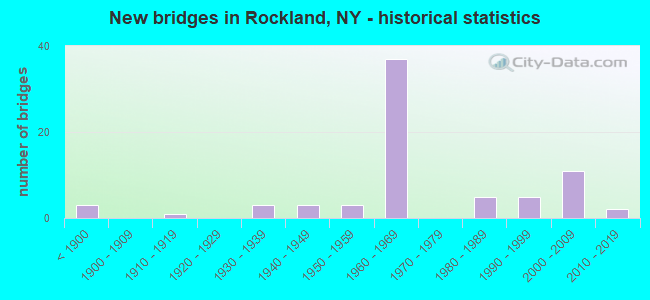
- New bridges - historical statistics
- 3Before 1900
- 11910-1919
- 31930-1939
- 31940-1949
- 31950-1959
- 371960-1969
- 51980-1989
- 51990-1999
- 112000-2009
- 22010-2019

- Reconstructed bridges - Historical Statistics
- 141980-1989
- 51990-1999
- 62000-2009
- 32010-2019


- Bridge Condition - Deck
- 10.3%Excellent
- 20.7%Very good
- 37.9%Good
- 19.0%Satisfactory
- 10.3%Fair
- 1.7%Poor

- Bridge Condition - Superstructure
- 6.9%Excellent
- 22.4%Very good
- 43.1%Good
- 17.2%Satisfactory
- 8.6%Fair
- 1.7%Poor

- Bridge Condition - Substructure
- 1.7%Excellent
- 15.5%Very good
- 25.9%Good
- 29.3%Satisfactory
- 24.1%Fair
- 3.4%Critical

- Bridge Condition - Channel
- 3.8%Very good
- 22.6%Good
- 39.6%Satisfactory
- 34.0%Fair

- Bridge Condition - Culverts
- 66.7%Good
- 33.3%Satisfactory
Find on map >> Show street view
Structure Number: 335611, Location: AT LIVINGSTON MANOR (Lat: 41.900428, Lng: -74.828503), Route carried "on" structure: County highway , Year Built: 1935, Year Reconstructed: 1987, Status: Open, Structure Length: 1.98m (6.50ft), Average Daily Traffic: 2,685 (year 2017), Truck Traffic: 7%, Average Future Daily Traffic: 3,759 (year 2037), Design Load: HS 20+Mod, Features Intersected: LITT BEAVER KILL, Facility Carried by Structure: COUNTY ROAD 149
Minimum Vertical Clearance: 30+ m (98+ ft), Kilometerpoint: 13.580, Lanes on structure: 2, Owner: County Highway Agency, Approaching Roadway Width: 7.9m (25.9ft), Material/Design: Prestressed concrete, Design/Construction: Box Beam or Girders - Multiple, Number Of Spans In Main Unit: 1, Length of Maximum Span: 19.2m (63.0ft), Curb or Sidewalk Widths: Left: 1.5m (4.9ft), Right: 1.5m (4.9ft), Curb-To-Curb Width: 7.8m (25.6ft), Out-to-Out Width: 11.4m (37.4ft)
Condition: Deck: Satisfactory, Superstructure: Good, Substructure: Fair, Channel: Fair, Operating Rating: 94.3 metric tons, Method Used To Determine Operating Rating: Load Factor (LF), Inventory Rating: 56.2 metric tons, Method Used To Determine Inventory Rating: Load Factor (LF), Structural Evaluation: Somewhat better than minimum adequacy, Deck Geometry: High priority of replacement, Waterway Adequacy: Meets minimum limits, Approach Roadway Alignment: Equal to present desirable criteria, Length Of Structure Improvement: 1.98m (6.50ft), Designated Inspection Frequency: Every 24 months, Inspection Date: June 2021, Bridge Improvement Cost: $731,000, Roadway Improvement Cost: $428,000, Total Project Cost: $1,159,000 ( Estimate for 2021), Wearing Surface/Protective System: Wearing Surface: Monolithic Concrete
Find on map >> Show street view
Structure Number: 335612, Location: 2.2 MI N OF LVINGSTON MNR (Lat: 41.931014, Lng: -74.829267), Route carried "on" structure: County highway , Year Built: 1988, Status: Open, Structure Length: 0.73m (2.40ft), Average Daily Traffic: 871 (year 2017), Truck Traffic: 7%, Average Future Daily Traffic: 1,219 (year 2037), Features Intersected: ELM HOLLOW BROOK, Facility Carried by Structure: COUNTY ROAD 151
Minimum Vertical Clearance: 30+ m (98+ ft), Kilometerpoint: 1.223, Lanes on structure: 2, Owner: County Highway Agency, Approaching Roadway Width: 6.7m (22.0ft), Skew: 1 degrees, Material/Design: Concrete, Design/Construction: Culvert, Number Of Spans In Main Unit: 1, Length of Maximum Span: 7.0m (23.0ft)
Condition: Channel: Satisfactory, Culverts: Satisfactory, Inventory Rating: 61.7 metric tons, Method Used To Determine Inventory Rating: Load Factor (LF), Structural Evaluation: Equal to present minimum criteria, Waterway Adequacy: Somewhat better than minimum adequacy, Approach Roadway Alignment: Equal to present desirable criteria, Length Of Structure Improvement: 0.73m (2.40ft), Designated Inspection Frequency: Every 24 months, Inspection Date: June 2021, Bridge Improvement Cost: $126,000, Roadway Improvement Cost: $74,000, Total Project Cost: $200,000 ( Estimate for 2021)
Find on map >> Show street view
Structure Number: 335613, Location: IN LEWBEACH (Lat: 42.004800, Lng: -74.785125), Route carried "on" structure: County highway , Year Built: 1952, Status: Open, Structure Length: 1.28m (4.20ft), Average Daily Traffic: 356 (year 2018), Truck Traffic: 14%, Average Future Daily Traffic: 498 (year 2038), Design Load: HS 20, Features Intersected: SHIN CREEK, Facility Carried by Structure: COUNTY ROAD 152
Minimum Vertical Clearance: 30+ m (98+ ft), Kilometerpoint: 4.698, Lanes on structure: 2, Owner: County Highway Agency, Approaching Roadway Width: 6.7m (22.0ft), Material/Design: Steel, Design/Construction: Stringer/Multi-beam, Number Of Spans In Main Unit: 1, Length of Maximum Span: 11.8m (38.7ft), Curb-To-Curb Width: 6.7m (22.0ft), Out-to-Out Width: 7.8m (25.6ft)
Condition: Deck: Good, Superstructure: Very good, Substructure: Good, Channel: Fair, Operating Rating: 67.1 metric tons, Method Used To Determine Operating Rating: Load Factor (LF), Inventory Rating: 39.9 metric tons, Method Used To Determine Inventory Rating: Load Factor (LF), Structural Evaluation: Better than present minimum criteria, Deck Geometry: Meets minimum limits, Waterway Adequacy: Meets minimum limits, Approach Roadway Alignment: Equal to present desirable criteria, Length Of Structure Improvement: 1.28m (4.20ft), Designated Inspection Frequency: Every 24 months, Inspection Date: July 2021, Bridge Improvement Cost: $384,000, Roadway Improvement Cost: $225,000, Total Project Cost: $609,000 ( Estimate for 2021), Deck Structure Type: Concrete Cast-file-Place, Wearing Surface/Protective System: Wearing Surface: Bituminous
Find on map >> Show street view
Structure Number: 335629, Location: IN LIVINGSTON MANOR (Lat: 41.903392, Lng: -74.824456), Route carried "on" structure: County highway , Year Built: 1960, Status: Open, Structure Length: 3.54m (11.61ft), Average Daily Traffic: 3,496 (year 2016), Truck Traffic: 4%, Average Future Daily Traffic: 4,894 (year 2036), Design Load: HS 20+Mod, Features Intersected: WILLOWEMOC CREEK, Facility Carried by Structure: COUNTY ROAD 178
Minimum Vertical Clearance: 30+ m (98+ ft), Kilometerpoint: 4.730, Lanes on structure: 2, Owner: County Highway Agency, Approaching Roadway Width: 11.3m (37.1ft), Skew: 3 degrees, Material/Design: Steel, Design/Construction: Stringer/Multi-beam, Number Of Spans In Main Unit: 1, Length of Maximum Span: 33.8m (110.9ft), Curb or Sidewalk Widths: Left: 1.0m (3.3ft), Right: 1.0m (3.3ft), Curb-To-Curb Width: 8.5m (27.9ft), Out-to-Out Width: 11.2m (36.7ft)
Condition: Deck: Fair, Superstructure: Satisfactory, Substructure: Fair, Channel: Good, Operating Rating: 57.2 metric tons, Method Used To Determine Operating Rating: Load Factor (LF), Inventory Rating: 33.6 metric tons, Method Used To Determine Inventory Rating: Load Factor (LF), Structural Evaluation: Somewhat better than minimum adequacy, Deck Geometry: Meets minimum limits, Waterway Adequacy: Somewhat better than minimum adequacy, Approach Roadway Alignment: Superior to present desirable criteria, Length Of Structure Improvement: 3.53m (11.58ft), Designated Inspection Frequency: Every 24 months, Inspection Date: August 2021, Bridge Improvement Cost: $1,419,000, Roadway Improvement Cost: $831,000, Total Project Cost: $2,251,000 ( Estimate for 2021), Deck Structure Type: Concrete Cast-file-Place, Wearing Surface/Protective System: Wearing Surface: Bituminous
Find on map >> Show street view
Structure Number: 33563, Location: .3 MI WEST OF ROSCOE (Lat: 41.936475, Lng: -74.919914), Route carried "on" structure: County highway , Year Built: 2014, Status: Open, Structure Length: 3.32m (10.89ft), Average Daily Traffic: 430 (year 2020), Truck Traffic: 5%, Average Future Daily Traffic: 602 (year 2040), Design Load: HL 93, Features Intersected: BEAVERKILL RIVER, Facility Carried by Structure: COUNTY ROAD 179A
Minimum Vertical Clearance: 32.69m (107.25ft), Kilometerpoint: 0.386, Lanes on structure: 2, Owner: County Highway Agency, Approaching Roadway Width: 11.0m (36.1ft), Skew: 3 degrees, Material/Design: Prestressed concrete, Design/Construction: Box Beam or Girders - Multiple, Number Of Spans In Main Unit: 1, Length of Maximum Span: 32.0m (105.0ft), Curb-To-Curb Width: 9.1m (29.9ft), Out-to-Out Width: 10.4m (34.1ft)
Condition: Deck: Very good, Superstructure: Excellent, Substructure: Very good, Channel: Very good, Operating Rating: 95.4 metric tons, Method Used To Determine Operating Rating: Field evaluation and documented engineering judgment, Inventory Rating: 40.8 metric tons, Method Used To Determine Inventory Rating: Field evaluation and documented engineering judgment, Structural Evaluation: Equal to present desirable criteria, Deck Geometry: Equal to present minimum criteria, Waterway Adequacy: Equal to present minimum criteria, Approach Roadway Alignment: Better than present minimum criteria, Length Of Structure Improvement: 3.32m (10.89ft), Designated Inspection Frequency: Every 24 months, Inspection Date: November 2020, Bridge Improvement Cost: $889,000, Roadway Improvement Cost: $521,000, Total Project Cost: $1,410,000 ( Estimate for 2021), Wearing Surface/Protective System: Wearing Surface: Bituminous, Membrane: Other
Find on map >> Show street view
Structure Number: 335633, Location: 1.5 MI NW OF LIV MANOR (Lat: 41.922958, Lng: -74.836256), Route carried "on" structure: County highway , Year Built: 1966, Year Reconstructed: 2008, Status: Open, Structure Length: 0.73m (2.40ft), Average Daily Traffic: 804 (year 2018), Truck Traffic: 7%, Average Future Daily Traffic: 1,126 (year 2038), Design Load: HS 20, Features Intersected: ELM HOLLOW BROOK, Facility Carried by Structure: COUNTY ROAD 179
Minimum Vertical Clearance: 30+ m (98+ ft), Kilometerpoint: 8.174, Lanes on structure: 2, Owner: County Highway Agency, Approaching Roadway Width: 7.3m (24.0ft), Skew: 2 degrees, Material/Design: Concrete, Design/Construction: Culvert, Number Of Spans In Main Unit: 1, Length of Maximum Span: 6.0m (19.7ft)
Condition: Channel: Fair, Culverts: Good, Operating Rating: 76.9 metric tons, Method Used To Determine Operating Rating: Field evaluation and documented engineering judgment, Inventory Rating: 32.7 metric tons, Method Used To Determine Inventory Rating: Field evaluation and documented engineering judgment, Structural Evaluation: Better than present minimum criteria, Waterway Adequacy: Somewhat better than minimum adequacy, Approach Roadway Alignment: Superior to present desirable criteria, Length Of Structure Improvement: 0.73m (2.40ft), Designated Inspection Frequency: Every 24 months, Inspection Date: August 2021, Bridge Improvement Cost: $217,000, Roadway Improvement Cost: $127,000, Total Project Cost: $344,000 ( Estimate for 2021), Wearing Surface/Protective System: Wearing Surface: Bituminous
Find on map >> Show street view
Structure Number: 335719, Location: 1.6 MILES E OF LEWBEACH (Lat: 41.996586, Lng: -74.755775), Route carried "on" structure: Alternate Other road , Year Built: 2003, Status: Open, Structure Length: 1.01m (3.31ft), Average Daily Traffic: 21 (year 2017), Truck Traffic: 5%, Average Future Daily Traffic: 29 (year 2037), Design Load: HS 25 or greater, Features Intersected: SHIN CREEK, Facility Carried by Structure: SHIN CREEK ROAD
Minimum Vertical Clearance: 30+ m (98+ ft), Kilometerpoint: 2.880, Lanes on structure: 2, Owner: County Highway Agency, Approaching Roadway Width: 6.7m (22.0ft), Skew: 3 degrees, Material/Design: Prestressed concrete, Design/Construction: Box Beam or Girders - Multiple, Number Of Spans In Main Unit: 1, Length of Maximum Span: 8.8m (28.9ft), Curb-To-Curb Width: 6.7m (22.0ft), Out-to-Out Width: 7.3m (24.0ft)
Condition: Deck: Very good, Superstructure: Excellent, Substructure: Excellent, Channel: Satisfactory, Operating Rating: 77.1 metric tons, Method Used To Determine Operating Rating: Load Factor (LF), Inventory Rating: 46.3 metric tons, Method Used To Determine Inventory Rating: Load Factor (LF), Structural Evaluation: Superior to present desirable criteria, Deck Geometry: Somewhat better than minimum adequacy, Waterway Adequacy: Somewhat better than minimum adequacy, Approach Roadway Alignment: High priority of corrective action, Length Of Structure Improvement: 1.00m (3.28ft), Designated Inspection Frequency: Every 24 months, Inspection Date: July 2021, Bridge Improvement Cost: $260,000, Roadway Improvement Cost: $152,000, Total Project Cost: $413,000 ( Estimate for 2021), Wearing Surface/Protective System: Wearing Surface: Bituminous
Find on map >> Show street view
Structure Number: 33572, Location: AT LIVINGSTON MANOR (Lat: 41.900553, Lng: -74.831508), Route carried "on" structure: Other road , Year Built: 1930, Year Reconstructed: 1992, Status: Open, Structure Length: 1.25m (4.10ft), Average Daily Traffic: 525 (year 2019), Truck Traffic: 5%, Average Future Daily Traffic: 735 (year 2039), Features Intersected: CATTAIL BROOK, Facility Carried by Structure: CREAMERY ROAD
Minimum Vertical Clearance: 30+ m (98+ ft), Kilometerpoint: 0.225, Lanes on structure: 2, Owner: County Highway Agency, Approaching Roadway Width: 7.6m (24.9ft), Skew: 4 degrees, Material/Design: Steel, Design/Construction: Stringer/Multi-beam, Number Of Spans In Main Unit: 1, Length of Maximum Span: 10.6m (34.8ft), Curb-To-Curb Width: 7.3m (24.0ft), Out-to-Out Width: 7.8m (25.6ft)
Condition: Deck: Fair, Superstructure: Satisfactory, Substructure: Critical, Channel: Fair, Operating Rating: 89.8 metric tons, Method Used To Determine Operating Rating: Load Factor (LF), Inventory Rating: 60.8 metric tons, Method Used To Determine Inventory Rating: Load Factor (LF), Structural Evaluation: High priority of replacement, Deck Geometry: Meets minimum limits, Waterway Adequacy: Meets minimum limits, Approach Roadway Alignment: Equal to present minimum criteria, Length Of Structure Improvement: 1.24m (4.07ft), Designated Inspection Frequency: Every 24 months, Inspection Date: June 2021, Bridge Improvement Cost: $510,000, Roadway Improvement Cost: $299,000, Total Project Cost: $809,000 ( Estimate for 2021), Deck Structure Type: Concrete Cast-file-Place, Wearing Surface/Protective System: Wearing Surface: Integral Concrete, Deck Protection: Epoxy Coated Reinforcing
Find on map >> Show street view
Structure Number: 335721, Location: 2.2 MI E OF LVINGSTON MNR (Lat: 41.906239, Lng: -74.785103), Route carried "on" structure: Other road , Year Built: 1935, Status: Open, Structure Length: 1.43m (4.69ft), Average Daily Traffic: 244 (year 2017), Truck Traffic: 10%, Average Future Daily Traffic: 342 (year 2037), Features Intersected: SPRAGUE BROOK, Facility Carried by Structure: GROOVILLE ROAD
Minimum Vertical Clearance: 30+ m (98+ ft), Kilometerpoint: 0.451, Lanes on structure: 2, Owner: County Highway Agency, Approaching Roadway Width: 9.1m (29.9ft), Skew: 4 degrees, Material/Design: Steel, Design/Construction: Stringer/Multi-beam, Number Of Spans In Main Unit: 1, Length of Maximum Span: 14.0m (45.9ft), Curb-To-Curb Width: 6.7m (22.0ft), Out-to-Out Width: 7.8m (25.6ft)
Condition: Deck: Good, Superstructure: Good, Substructure: Fair, Channel: Good, Operating Rating: 44.5 metric tons, Method Used To Determine Operating Rating: Load Factor (LF), Inventory Rating: 26.3 metric tons, Method Used To Determine Inventory Rating: Load Factor (LF), Structural Evaluation: Somewhat better than minimum adequacy, Deck Geometry: Meets minimum limits, Waterway Adequacy: Meets minimum limits, Approach Roadway Alignment: Equal to present desirable criteria, Length Of Structure Improvement: 1.43m (4.69ft), Designated Inspection Frequency: Every 24 months, Inspection Date: September 2021, Bridge Improvement Cost: $418,000, Roadway Improvement Cost: $245,000, Total Project Cost: $662,000 ( Estimate for 2021), Deck Structure Type: Concrete Cast-file-Place, Wearing Surface/Protective System: Wearing Surface: Bituminous
Find on map >> Show street view
Structure Number: 335722, Location: 2.5 MI NE OF COUNTY RD 82 (Lat: 41.931208, Lng: -74.769681), Route carried "on" structure: Other road , Year Built: 1993, Status: Open, Structure Length: 1.10m (3.61ft), Average Daily Traffic: 244 (year 2017), Truck Traffic: 10%, Average Future Daily Traffic: 342 (year 2037), Design Load: HS 20, Features Intersected: SPRAGUE BROOK, Facility Carried by Structure: GROOVILLE ROAD
Minimum Vertical Clearance: 30+ m (98+ ft), Kilometerpoint: 3.717, Lanes on structure: 2, Owner: County Highway Agency, Approaching Roadway Width: 5.5m (18.0ft), Skew: 1 degrees, Material/Design: Steel, Design/Construction: Stringer/Multi-beam, Number Of Spans In Main Unit: 1, Length of Maximum Span: 10.0m (32.8ft), Curb-To-Curb Width: 6.8m (22.3ft), Out-to-Out Width: 7.3m (24.0ft)
Condition: Deck: Good, Superstructure: Fair, Substructure: Good, Channel: Satisfactory, Operating Rating: 68.0 metric tons, Method Used To Determine Operating Rating: Load Factor (LF), Inventory Rating: 40.8 metric tons, Method Used To Determine Inventory Rating: Load Factor (LF), Structural Evaluation: Somewhat better than minimum adequacy, Deck Geometry: Meets minimum limits, Waterway Adequacy: Meets minimum limits, Approach Roadway Alignment: Meets minimum limits, Length Of Structure Improvement: 1.09m (3.58ft), Designated Inspection Frequency: Every 24 months, Inspection Date: September 2021, Bridge Improvement Cost: $285,000, Roadway Improvement Cost: $167,000, Total Project Cost: $453,000 ( Estimate for 2021), Deck Structure Type: Wood or Timber, Wearing Surface/Protective System: Wearing Surface: Bituminous
Find on map >> Show street view
Structure Number: 335723, Location: 1.8 MI E OF DEBRUCE (Lat: 41.906661, Lng: -74.699503), Route carried "on" structure: Other road , Year Built: 1865, Status: Closed, Structure Length: 2.01m (6.59ft), Truck Traffic: 5%, Features Intersected: WILLOWEMOC CREEK, Facility Carried by Structure: CONKLIN HILL ROAD
Minimum Vertical Clearance: 2.92m (9.58ft), Kilometerpoint: 1.609, Lanes on structure: 1, Owner: County Highway Agency, Approaching Roadway Width: 4.9m (16.1ft), Material/Design: Steel, Design/Construction: Girder and Floorbeam System, Number Of Spans In Main Unit: 1, Number Of Approach Spans: 2, Length of Maximum Span: 14.3m (46.9ft), Curb-To-Curb Width: 3.5m (11.5ft), Out-to-Out Width: 5.1m (16.7ft)
Condition: Deck: Fair, Superstructure: Fair, Substructure: Satisfactory, Channel: Satisfactory, Waterway Adequacy: Meets minimum limits, Approach Roadway Alignment: Equal to present desirable criteria, Bridge Posting: Required (Relationship of Operating Rating to Maximum Legal Load: > 39.9% below), Length Of Structure Improvement: 2.01m (6.59ft), Designated Inspection Frequency: Every 12 months, Critical Feature Inspection Frequency: Every 12 months, Inspection Date: June 2021, Critical Feature Inspection Date: June 2021, Bridge Improvement Cost: $266,000, Roadway Improvement Cost: $156,000, Total Project Cost: $421,000 ( Estimate for 2021), Deck Structure Type: Wood or Timber, Wearing Surface/Protective System: Wearing Surface: Wood or Timber
Find on map >> Show street view
Structure Number: 335724, Location: 0.1 MI N OF CR152 IN LEWB (Lat: 42.005675, Lng: -74.785819), Route carried "on" structure: Other road , Year Built: 1989, Year Reconstructed: 2010, Status: Open, Structure Length: 3.14m (10.30ft), Average Daily Traffic: 77 (year 2019), Truck Traffic: 5%, Average Future Daily Traffic: 108 (year 2039), Design Load: HS 20, Features Intersected: BEAVER KILL, Facility Carried by Structure: MARY SMITH HLL RD
Minimum Vertical Clearance: 30+ m (98+ ft), Kilometerpoint: 0.113, Lanes on structure: 1, Owner: County Highway Agency, Approaching Roadway Width: 5.5m (18.0ft), Material/Design: Steel, Design/Construction: Truss - Thru, Number Of Spans In Main Unit: 1, Length of Maximum Span: 31.0m (101.7ft), Curb-To-Curb Width: 4.9m (16.1ft), Out-to-Out Width: 5.7m (18.7ft)
Condition: Deck: Good, Superstructure: Good, Substructure: Good, Channel: Satisfactory, Operating Rating: 60.8 metric tons, Method Used To Determine Operating Rating: Load Factor (LF), Inventory Rating: 36.3 metric tons, Method Used To Determine Inventory Rating: Load Factor (LF), Structural Evaluation: Better than present minimum criteria, Deck Geometry: High priority of corrective action, Waterway Adequacy: Somewhat better than minimum adequacy, Approach Roadway Alignment: Somewhat better than minimum adequacy, Length Of Structure Improvement: 3.13m (10.27ft), Designated Inspection Frequency: Every 24 months, Critical Feature Inspection Frequency: Every 24 months, Inspection Date: July 2020, Critical Feature Inspection Date: July 2020, Bridge Improvement Cost: $1,406,000, Roadway Improvement Cost: $823,000, Total Project Cost: $2,229,000 ( Estimate for 2021), Deck Structure Type: Corrugated Steel, Wearing Surface/Protective System: Wearing Surface: Bituminous
Find on map >> Show street view
Structure Number: 335726, Location: AT BEAVERKILL (Lat: 41.981514, Lng: -74.836228), Route carried "on" structure: Other road , Year Built: 1865, Year Reconstructed: 2017, Status: Posted for load, Structure Length: 3.87m (12.70ft), Average Daily Traffic: 46 (year 2018), Truck Traffic: 5%, Average Future Daily Traffic: 64 (year 2038), Features Intersected: BEAVER KILL, Facility Carried by Structure: CRAIGIE CLAIR RD
Minimum Vertical Clearance: 3.15m (10.33ft), Kilometerpoint: 1.062, Lanes on structure: 1, Owner: Town or Township Highway Agency, Maintenance Responsibility: County Highway Agency, Approaching Roadway Width: 4.0m (13.1ft), Material/Design: Wood or Timber, Design/Construction: Truss - Thru, Number Of Spans In Main Unit: 1, Number Of Approach Spans: 1, Length of Maximum Span: 33.8m (110.9ft), Curb-To-Curb Width: 3.6m (11.8ft), Out-to-Out Width: 5.0m (16.4ft)
Condition: Deck: Good, Superstructure: Satisfactory, Substructure: Good, Channel: Good, Operating Rating: 2.7 metric tons, Method Used To Determine Operating Rating: Field evaluation and documented engineering judgment, Inventory Rating: 2.7 metric tons, Method Used To Determine Inventory Rating: Field evaluation and documented engineering judgment, Structural Evaluation: High priority of corrective action, Deck Geometry: High priority of corrective action, Waterway Adequacy: Somewhat better than minimum adequacy, Approach Roadway Alignment: Equal to present minimum criteria, Bridge Posting: Required (Relationship of Operating Rating to Maximum Legal Load: > 39.9% below), Length Of Structure Improvement: 3.87m (12.70ft), Designated Inspection Frequency: Every 12 months, Critical Feature Inspection Frequency: Every 12 months, Inspection Date: July 2021, Critical Feature Inspection Date: July 2021, Bridge Improvement Cost: $1,395,000, Roadway Improvement Cost: $817,000, Total Project Cost: $2,212,000 ( Estimate for 2021), Deck Structure Type: Wood or Timber, Wearing Surface/Protective System: Wearing Surface: Wood or Timber
Find on map >> Show street view
Structure Number: 335727, Location: 2.5 MI SW OF BEAVERKILL (Lat: 41.963356, Lng: -74.866553), Route carried "on" structure: Bypass Other road , Year Built: 2007, Status: Open, Structure Length: 3.23m (10.60ft), Average Daily Traffic: 58 (year 2018), Truck Traffic: 10%, Average Future Daily Traffic: 81 (year 2038), Features Intersected: BEAVER KILL, Facility Carried by Structure: CRAIGIE CLAIR RD
Minimum Vertical Clearance: 4.95m (16.24ft), Kilometerpoint: 0.000, Lanes on structure: 1, Owner: County Highway Agency, Approaching Roadway Width: 5.2m (17.1ft), Material/Design: Steel, Design/Construction: Truss - Thru, Number Of Spans In Main Unit: 1, Length of Maximum Span: 31.1m (102.0ft), Curb-To-Curb Width: 4.9m (16.1ft), Out-to-Out Width: 6.2m (20.3ft)
Condition: Deck: Good, Superstructure: Very good, Substructure: Very good, Channel: Very good, Operating Rating: 59.0 metric tons, Method Used To Determine Operating Rating: Load Factor (LF), Inventory Rating: 35.4 metric tons, Method Used To Determine Inventory Rating: Load Factor (LF), Structural Evaluation: Equal to present desirable criteria, Deck Geometry: High priority of corrective action, Waterway Adequacy: Somewhat better than minimum adequacy, Approach Roadway Alignment: High priority of replacement, Length Of Structure Improvement: 3.23m (10.60ft), Designated Inspection Frequency: Every 24 months, Critical Feature Inspection Frequency: Every 24 months, Inspection Date: June 2021, Critical Feature Inspection Date: June 2021, Bridge Improvement Cost: $1,524,000, Roadway Improvement Cost: $893,000, Total Project Cost: $2,417,000 ( Estimate for 2021), Deck Structure Type: Concrete Cast-file-Place, Wearing Surface/Protective System: Wearing Surface: Integral Concrete, Deck Protection: Epoxy Coated Reinforcing
Find on map >> Show street view
Structure Number: 335728, Location: 2.4 MI SE OF LVINGSTN MNR (Lat: 41.876906, Lng: -74.801658), Route carried "on" structure: Alternate Other road , Year Built: 1963, Status: Closed, Structure Length: 1.83m (6.00ft), Average Daily Traffic: 70 (year 2009), Truck Traffic: 6%, Average Future Daily Traffic: 70 (year 2037), Features Intersected: LITTLE BEAVER KILL, Facility Carried by Structure: OLD LIBERTY ROAD
Minimum Vertical Clearance: 30+ m (98+ ft), Kilometerpoint: 0.000, Lanes on structure: 1, Owner: County Highway Agency, Approaching Roadway Width: 5.5m (18.0ft), Material/Design: Wood or Timber, Design/Construction: Stringer/Multi-beam, Number Of Spans In Main Unit: 3, Length of Maximum Span: 6.0m (19.7ft), Curb-To-Curb Width: 3.2m (10.5ft), Out-to-Out Width: 4.3m (14.1ft)
Condition: Deck: Satisfactory, Superstructure: Satisfactory, Substructure: Critical, Channel: Fair, Waterway Adequacy: Somewhat better than minimum adequacy, Approach Roadway Alignment: High priority of corrective action, Bridge Posting: Required (Relationship of Operating Rating to Maximum Legal Load: > 39.9% below), Length Of Structure Improvement: 1.82m (5.97ft), Designated Inspection Frequency: Every 12 months, Inspection Date: June 2021, Bridge Improvement Cost: $219,000, Roadway Improvement Cost: $128,000, Total Project Cost: $347,000 ( Estimate for 2021), Deck Structure Type: Wood or Timber, Wearing Surface/Protective System: Wearing Surface: Wood or Timber
Find on map >> Show street view
Structure Number: 335729, Location: AT INT W DEBRUCE RD (Lat: 41.911569, Lng: -74.724664), Route carried "on" structure: Other road , Year Built: 1992, Year Reconstructed: 2018, Status: Open, Structure Length: 3.75m (12.30ft), Average Daily Traffic: 118 (year 2019), Truck Traffic: 4%, Average Future Daily Traffic: 165 (year 2039), Design Load: HS 20, Features Intersected: WILLOWEMOC CREEK, Facility Carried by Structure: HUNTER LAKE ROAD
Minimum Vertical Clearance: 30+ m (98+ ft), Kilometerpoint: 3.202, Lanes on structure: 2, Owner: County Highway Agency, Approaching Roadway Width: 5.5m (18.0ft), Material/Design: Steel, Design/Construction: Truss - Thru, Number Of Spans In Main Unit: 1, Length of Maximum Span: 37.1m (121.7ft), Curb-To-Curb Width: 7.3m (24.0ft), Out-to-Out Width: 7.5m (24.6ft)
Condition: Deck: Excellent, Superstructure: Excellent, Substructure: Good, Channel: Fair, Operating Rating: 64.4 metric tons, Method Used To Determine Operating Rating: Load Factor (LF), Inventory Rating: 49.0 metric tons, Method Used To Determine Inventory Rating: Load Factor (LF), Structural Evaluation: Better than present minimum criteria, Deck Geometry: Somewhat better than minimum adequacy, Waterway Adequacy: Somewhat better than minimum adequacy, Approach Roadway Alignment: Equal to present desirable criteria, Length Of Structure Improvement: 3.74m (12.27ft), Designated Inspection Frequency: Every 24 months, Critical Feature Inspection Frequency: Every 24 months, Inspection Date: November 2020, Critical Feature Inspection Date: November 2020, Bridge Improvement Cost: $1,901,000, Roadway Improvement Cost: $1,113,000, Total Project Cost: $3,014,000 ( Estimate for 2021), Deck Structure Type: Corrugated Steel, Wearing Surface/Protective System: Wearing Surface: Bituminous
Find on map >> Show street view
Structure Number: 33573, Location: 1 MI NW LIVINGSTON MANOR (Lat: 41.914847, Lng: -74.831828), Route carried "on" structure: Other road , Year Built: 1860, Year Reconstructed: 1986, Status: Posted for load, Structure Length: 3.87m (12.70ft), Average Daily Traffic: 193 (year 2019), Truck Traffic: 5%, Average Future Daily Traffic: 270 (year 2039), Features Intersected: WILLOWEMOC CREEK, Facility Carried by Structure: COVERED BRIDGE RD
Minimum Vertical Clearance: 2.74m (8.99ft), Kilometerpoint: 1.126, Lanes on structure: 1, Owner: County Highway Agency, Approaching Roadway Width: 3.7m (12.1ft), Material/Design: Wood or Timber, Design/Construction: Arch - Thru, Number Of Spans In Main Unit: 1, Number Of Approach Spans: 1, Length of Maximum Span: 28.9m (94.8ft), Curb-To-Curb Width: 3.4m (11.2ft), Out-to-Out Width: 4.1m (13.5ft)
Condition: Deck: Satisfactory, Superstructure: Fair, Substructure: Fair, Channel: Good, Operating Rating: 4.5 metric tons, Method Used To Determine Operating Rating: Field evaluation and documented engineering judgment, Inventory Rating: 4.5 metric tons, Method Used To Determine Inventory Rating: Field evaluation and documented engineering judgment, Structural Evaluation: High priority of corrective action, Deck Geometry: High priority of replacement, Waterway Adequacy: Equal to present minimum criteria, Approach Roadway Alignment: High priority of replacement, Bridge Posting: Required (Relationship of Operating Rating to Maximum Legal Load: > 39.9% below), Length Of Structure Improvement: 3.87m (12.70ft), Designated Inspection Frequency: Every 12 months, Critical Feature Inspection Frequency: Every 12 months, Inspection Date: July 2021, Critical Feature Inspection Date: July 2021, Bridge Improvement Cost: $878,000, Roadway Improvement Cost: $514,000, Total Project Cost: $1,393,000 ( Estimate for 2021), Deck Structure Type: Wood or Timber, Wearing Surface/Protective System: Wearing Surface: Wood or Timber
Find on map >> Show street view
Structure Number: 335731, Location: .7 MILE NORTH OF DEBRUCE (Lat: 41.921881, Lng: -74.718197), Route carried "on" structure: Other road , Year Built: 2004, Status: Open, Structure Length: 1.55m (5.09ft), Average Daily Traffic: 63 (year 2018), Truck Traffic: 3%, Average Future Daily Traffic: 88 (year 2038), Design Load: HS 25 or greater, Features Intersected: MONGAUP CREEK, Facility Carried by Structure: MONGAUP ROAD
Minimum Vertical Clearance: 30+ m (98+ ft), Kilometerpoint: 1.191, Lanes on structure: 2, Owner: County Highway Agency, Approaching Roadway Width: 7.3m (24.0ft), Skew: 4 degrees, Material/Design: Prestressed concrete, Design/Construction: Box Beam or Girders - Multiple, Number Of Spans In Main Unit: 1, Length of Maximum Span: 14.6m (47.9ft), Curb-To-Curb Width: 6.8m (22.3ft), Out-to-Out Width: 7.4m (24.3ft)
Condition: Deck: Excellent, Superstructure: Very good, Substructure: Very good, Channel: Good, Operating Rating: 73.5 metric tons, Method Used To Determine Operating Rating: Load Factor (LF), Inventory Rating: 43.5 metric tons, Method Used To Determine Inventory Rating: Load Factor (LF), Structural Evaluation: Equal to present desirable criteria, Deck Geometry: Somewhat better than minimum adequacy, Waterway Adequacy: Somewhat better than minimum adequacy, Approach Roadway Alignment: Somewhat better than minimum adequacy, Length Of Structure Improvement: 1.55m (5.09ft), Designated Inspection Frequency: Every 24 months, Inspection Date: July 2020, Bridge Improvement Cost: $413,000, Roadway Improvement Cost: $242,000, Total Project Cost: $654,000 ( Estimate for 2021), Wearing Surface/Protective System: Wearing Surface: Bituminous
Find on map >> Show street view
Structure Number: 335732, Location: 2.8 MI E OF LIV MANOR (Lat: 41.903728, Lng: -74.773711), Route carried "on" structure: Alternate Other road , Year Built: 2009, Status: Open, Structure Length: 2.38m (7.81ft), Average Daily Traffic: 126 (year 2019), Truck Traffic: 4%, Average Future Daily Traffic: 176 (year 2039), Design Load: HS 25 or greater, Features Intersected: WILLOWEMOC CREEK, Facility Carried by Structure: PARKSTON ROAD
Minimum Vertical Clearance: 30+ m (98+ ft), Kilometerpoint: 0.097, Lanes on structure: 2, Owner: County Highway Agency, Approaching Roadway Width: 7.9m (25.9ft), Material/Design: Prestressed concrete, Design/Construction: Box Beam or Girders - Multiple, Number Of Spans In Main Unit: 1, Length of Maximum Span: 23.2m (76.1ft), Curb-To-Curb Width: 7.9m (25.9ft), Out-to-Out Width: 8.6m (28.2ft)
Condition: Deck: Very good, Superstructure: Very good, Substructure: Very good, Channel: Good, Operating Rating: 50.5 metric tons, Method Used To Determine Operating Rating: Load and Resistance Factor Rating (LRFR) rating reported by rating factor(RF) method using HL-93 loadings, Inventory Rating: 38.9 metric tons, Method Used To Determine Inventory Rating: Load and Resistance Factor Rating (LRFR) rating reported by rating factor(RF) method using HL-93 loadings, Structural Evaluation: Equal to present desirable criteria, Deck Geometry: Somewhat better than minimum adequacy, Waterway Adequacy: Somewhat better than minimum adequacy, Approach Roadway Alignment: Equal to present minimum criteria, Length Of Structure Improvement: 2.37m (7.78ft), Designated Inspection Frequency: Every 24 months, Inspection Date: September 2021, Bridge Improvement Cost: $716,000, Roadway Improvement Cost: $419,000, Total Project Cost: $1,135,000 ( Estimate for 2021), Wearing Surface/Protective System: Wearing Surface: Bituminous
Find on map >> Show street view
Structure Number: 335745, Location: 5 MI NE OF LIVINGSTON MNR (Lat: 41.935044, Lng: -74.767875), Route carried "on" structure: Alternate Other road , Year Built: 2005, Status: Open, Structure Length: 1.01m (3.31ft), Average Daily Traffic: 244 (year 2017), Truck Traffic: 10%, Average Future Daily Traffic: 342 (year 2037), Design Load: HS 25 or greater, Features Intersected: SPRAGUE BROOK, Facility Carried by Structure: GROOVILLE ROAD
Minimum Vertical Clearance: 30+ m (98+ ft), Kilometerpoint: 4.216, Lanes on structure: 2, Owner: County Highway Agency, Approaching Roadway Width: 6.1m (20.0ft), Skew: 1 degrees, Material/Design: Prestressed concrete, Design/Construction: Box Beam or Girders - Multiple, Number Of Spans In Main Unit: 1, Length of Maximum Span: 9.4m (30.8ft), Curb-To-Curb Width: 6.8m (22.3ft), Out-to-Out Width: 7.4m (24.3ft)
Condition: Deck: Very good, Superstructure: Very good, Substructure: Very good, Channel: Satisfactory, Operating Rating: 89.8 metric tons, Method Used To Determine Operating Rating: Load Factor (LF), Inventory Rating: 53.5 metric tons, Method Used To Determine Inventory Rating: Load Factor (LF), Structural Evaluation: Equal to present desirable criteria, Deck Geometry: Meets minimum limits, Waterway Adequacy: Meets minimum limits, Approach Roadway Alignment: Meets minimum limits, Length Of Structure Improvement: 1.00m (3.28ft), Designated Inspection Frequency: Every 24 months, Inspection Date: September 2021, Bridge Improvement Cost: $269,000, Roadway Improvement Cost: $158,000, Total Project Cost: $427,000 ( Estimate for 2021), Wearing Surface/Protective System: Wearing Surface: Bituminous
Find on map >> Show street view
Structure Number: 335746, Location: AT LIVINGSTON MANOR (Lat: 41.901367, Lng: -74.830911), Route carried "on" structure: Other road , Year Built: 2002, Status: Open, Structure Length: 1.07m (3.51ft), Average Daily Traffic: 81 (year 2019), Truck Traffic: 1%, Average Future Daily Traffic: 113 (year 2039), Design Load: HS 25 or greater, Features Intersected: CATTAIL BROOK, Facility Carried by Structure: RIVER STREET
Minimum Vertical Clearance: 30+ m (98+ ft), Kilometerpoint: 0.225, Lanes on structure: 1, Owner: County Highway Agency, Approaching Roadway Width: 4.9m (16.1ft), Material/Design: Prestressed concrete, Design/Construction: Box Beam or Girders - Multiple, Number Of Spans In Main Unit: 1, Length of Maximum Span: 10.2m (33.5ft), Curb-To-Curb Width: 4.9m (16.1ft), Out-to-Out Width: 5.5m (18.0ft)
Condition: Deck: Good, Superstructure: Good, Substructure: Very good, Channel: Satisfactory, Operating Rating: 69.9 metric tons, Method Used To Determine Operating Rating: Load Factor (LF), Inventory Rating: 40.8 metric tons, Method Used To Determine Inventory Rating: Load Factor (LF), Structural Evaluation: Better than present minimum criteria, Deck Geometry: High priority of corrective action, Waterway Adequacy: Meets minimum limits, Approach Roadway Alignment: Equal to present desirable criteria, Length Of Structure Improvement: 1.06m (3.48ft), Designated Inspection Frequency: Every 24 months, Inspection Date: July 2020, Bridge Improvement Cost: $215,000, Roadway Improvement Cost: $126,000, Total Project Cost: $342,000 ( Estimate for 2021), Wearing Surface/Protective System: Wearing Surface: Bituminous
Find on map >> Show street view
Structure Number: 336757, Location: 2.5 MI E EXIT 94 OF STE (Lat: 41.926350, Lng: -74.875231), Route carried "on" structure: Other road , Year Built: 1986, Year Reconstructed: 2014, Status: Open, Structure Length: 4.42m (14.50ft), Average Daily Traffic: 95 (year 2018), Truck Traffic: 9%, Average Future Daily Traffic: 133 (year 2038), Features Intersected: WILLOWEMOC CREEK, Facility Carried by Structure: HAZEL ROAD
Minimum Vertical Clearance: 30+ m (98+ ft), Kilometerpoint: 5.342, Lanes on structure: 2, Owner: County Highway Agency, Approaching Roadway Width: 5.5m (18.0ft), Material/Design: Steel, Design/Construction: Truss - Thru, Number Of Spans In Main Unit: 1, Length of Maximum Span: 42.9m (140.7ft), Curb-To-Curb Width: 7.3m (24.0ft), Out-to-Out Width: 7.5m (24.6ft)
Condition: Deck: Very good, Superstructure: Good, Substructure: Good, Channel: Satisfactory, Operating Rating: 56.2 metric tons, Method Used To Determine Operating Rating: Load Factor (LF), Inventory Rating: 33.6 metric tons, Method Used To Determine Inventory Rating: Load Factor (LF), Structural Evaluation: Better than present minimum criteria, Deck Geometry: Equal to present minimum criteria, Waterway Adequacy: Equal to present minimum criteria, Approach Roadway Alignment: Meets minimum limits, Length Of Structure Improvement: 4.41m (14.47ft), Designated Inspection Frequency: Every 24 months, Critical Feature Inspection Frequency: Every 24 months, Inspection Date: November 2020, Critical Feature Inspection Date: November 2020, Bridge Improvement Cost: $2,367,000, Roadway Improvement Cost: $1,386,000, Total Project Cost: $3,753,000 ( Estimate for 2021), Deck Structure Type: Corrugated Steel, Wearing Surface/Protective System: Wearing Surface: Bituminous
Find on map >> Show street view
Structure Number: 336792, Location: .3 MILE N JCT OLD RTE 17 (Lat: 41.924792, Lng: -74.832806), Route carried "on" structure: County highway , Year Built: 1988, Status: Open, Structure Length: 0.73m (2.40ft), Average Daily Traffic: 871 (year 2017), Truck Traffic: 7%, Average Future Daily Traffic: 1,219 (year 2037), Features Intersected: ELM HOLLOW BROOK, Facility Carried by Structure: COUNTY ROAD 151
Minimum Vertical Clearance: 30+ m (98+ ft), Kilometerpoint: 2.430, Lanes on structure: 2, Owner: County Highway Agency, Approaching Roadway Width: 7.0m (23.0ft), Material/Design: Concrete, Design/Construction: Culvert, Number Of Spans In Main Unit: 1, Length of Maximum Span: 7.0m (23.0ft)
Condition: Channel: Fair, Culverts: Good, Operating Rating: 72.6 metric tons, Method Used To Determine Operating Rating: Load Factor (LF), Inventory Rating: 43.5 metric tons, Method Used To Determine Inventory Rating: Load Factor (LF), Structural Evaluation: Better than present minimum criteria, Waterway Adequacy: Meets minimum limits, Approach Roadway Alignment: Equal to present desirable criteria, Length Of Structure Improvement: 0.73m (2.40ft), Designated Inspection Frequency: Every 24 months, Inspection Date: August 2021, Bridge Improvement Cost: $91,000, Roadway Improvement Cost: $53,000, Total Project Cost: $144,000 ( Estimate for 2021)
Find on map >> Show street view
Structure Number: 336957, Location: 1.2 MI S OF LEW BEACH (Lat: 41.991261, Lng: -74.798728), Route carried "on" structure: County highway , Year Built: 2000, Status: Open, Structure Length: 1.01m (3.31ft), Average Daily Traffic: 356 (year 2018), Truck Traffic: 14%, Average Future Daily Traffic: 498 (year 2038), Design Load: HS 25 or greater, Features Intersected: VOORHEES BROOK, Facility Carried by Structure: JOHNSTON HILL RD
Minimum Vertical Clearance: 30+ m (98+ ft), Kilometerpoint: 2.526, Lanes on structure: 2, Owner: County Highway Agency, Approaching Roadway Width: 9.1m (29.9ft), Material/Design: Prestressed concrete, Design/Construction: Box Beam or Girders - Multiple, Number Of Spans In Main Unit: 1, Length of Maximum Span: 9.8m (32.2ft), Curb-To-Curb Width: 9.1m (29.9ft), Out-to-Out Width: 9.8m (32.2ft)
Condition: Deck: Good, Superstructure: Satisfactory, Substructure: Good, Channel: Fair, Operating Rating: 85.3 metric tons, Method Used To Determine Operating Rating: Load Factor (LF), Inventory Rating: 50.8 metric tons, Method Used To Determine Inventory Rating: Load Factor (LF), Structural Evaluation: Equal to present minimum criteria, Deck Geometry: Equal to present minimum criteria, Waterway Adequacy: Meets minimum limits, Approach Roadway Alignment: Equal to present desirable criteria, Length Of Structure Improvement: 1.00m (3.28ft), Designated Inspection Frequency: Every 24 months, Inspection Date: July 2020, Bridge Improvement Cost: $191,000, Roadway Improvement Cost: $112,000, Total Project Cost: $302,000 ( Estimate for 2021), Wearing Surface/Protective System: Wearing Surface: Bituminous, Membrane: Other
Find on map >> Show street view
Structure Number: 33697, Location: TOWN OF ROCKLAND-CO RD 92 (Lat: 41.920872, Lng: -74.930853), Route carried "on" structure: ServiceCounty highway , Year Built: 1995, Status: Open, Structure Length: 0.70m (2.30ft), Average Daily Traffic: 655 (year 2020), Truck Traffic: 6%, Average Future Daily Traffic: 917 (year 2040), Features Intersected: ABE WOOD BROOK, Facility Carried by Structure: COUNTY ROAD 92
Minimum Vertical Clearance: 30+ m (98+ ft), Kilometerpoint: 2.156, Lanes on structure: 2, Owner: County Highway Agency, Approaching Roadway Width: 8.5m (27.9ft), Skew: 1 degrees, Material/Design: Concrete, Design/Construction: Frame, Number Of Spans In Main Unit: 1, Length of Maximum Span: 6.4m (21.0ft), Curb-To-Curb Width: 8.8m (28.9ft), Out-to-Out Width: 9.8m (32.2ft)
Condition: Deck: Very good, Superstructure: Very good, Substructure: Good, Channel: Fair, Operating Rating: 74.4 metric tons, Method Used To Determine Operating Rating: Load Factor (LF), Inventory Rating: 44.5 metric tons, Method Used To Determine Inventory Rating: Load Factor (LF), Structural Evaluation: Better than present minimum criteria, Deck Geometry: Somewhat better than minimum adequacy, Waterway Adequacy: Meets minimum limits, Approach Roadway Alignment: Equal to present desirable criteria, Length Of Structure Improvement: 0.70m (2.30ft), Designated Inspection Frequency: Every 24 months, Inspection Date: July 2020, Bridge Improvement Cost: $186,000, Roadway Improvement Cost: $109,000, Total Project Cost: $295,000 ( Estimate for 2021), Wearing Surface/Protective System: Wearing Surface: Bituminous
Find on map >> Show street view
Structure Number: 1013501, Location: 0.1 MI SE EXIT 94-RTE 17 (Lat: 41.931467, Lng: -74.914003), Route carried "under" structure: Business Other road , Year Built: 1965, Structure Length: 0. m, Average Daily Traffic: 823 (year 2018), Truck Traffic: 8%, Features Intersected: BROAD STREET, Facility Carried by Structure: RTE 17
Minimum Vertical Clearance: 4.83m (15.85ft), Kilometerpoint: 0.274, Lanes on structure: 3, Lanes under structure: 2, Material/Design: Steel continuous, Design/Construction: Stringer/Multi-beam, Length of Maximum Span: 16.1m (52.8ft)
Find on map >> Show street view
Structure Number: 1013502, Location: 0.1 MI NW EXIT 94-RTE 17 (Lat: 41.931308, Lng: -74.914114), Route carried "under" structure: Business Other road , Year Built: 1965, Structure Length: 0. m, Average Daily Traffic: 823 (year 2018), Truck Traffic: 8%, Features Intersected: BROAD STREET, Facility Carried by Structure: RTE 17
Minimum Vertical Clearance: 5.00m (16.40ft), Kilometerpoint: 0.209, Lanes on structure: 2, Lanes under structure: 2, Material/Design: Steel continuous, Design/Construction: Stringer/Multi-beam, Length of Maximum Span: 16.1m (52.8ft)
Find on map >> Show street view
Structure Number: 101351, Location: 02 MI NW EXIT 96 RTE 17 (Lat: 41.907158, Lng: -74.821681), Route carried "under" structure: State highway 17, Year Built: 1963, Structure Length: 0. m, Average Daily Traffic: 8,816 (year 2020), Truck Traffic: 17%, Features Intersected: 17 17 96091074 WB, RTE, Facility Carried by Structure: WHITE ROE LAKE RD
Minimum Vertical Clearance: 5.66m (18.57ft), Kilometerpoint: 12.003, Lanes on structure: 2, Lanes under structure: 3, Material/Design: Steel, Design/Construction: Stringer/Multi-beam, Length of Maximum Span: 20.1m (65.9ft)
Find on map >> Show street view
Structure Number: 1013521, Location: EXIT 96/SH 17 INTERCHANGE (Lat: 41.906153, Lng: -74.819567), Route carried "under" structure: County highway , Year Built: 1963, Structure Length: 0. m, Average Daily Traffic: 401 (year 2016), Truck Traffic: 7%, Features Intersected: DE BRUCE RD-CR 81, WILLO, Facility Carried by Structure: RTE 17
Minimum Vertical Clearance: 5.41m (17.75ft), Kilometerpoint: 0.451, Lanes on structure: 3, Lanes under structure: 2, Material/Design: Steel, Design/Construction: Stringer/Multi-beam, Length of Maximum Span: 18.2m (59.7ft)
Find on map >> Show street view
Structure Number: 1013522, Location: EXIT 96/SH 17 INTERCHANGE (Lat: 41.906089, Lng: -74.819719), Route carried "under" structure: County highway , Year Built: 1963, Structure Length: 0. m, Average Daily Traffic: 401 (year 2016), Truck Traffic: 7%, Features Intersected: DE BRUCE RD-CR 81, WILLO, Facility Carried by Structure: RTE 17
Minimum Vertical Clearance: 5.74m (18.83ft), Kilometerpoint: 0.209, Lanes on structure: 3, Lanes under structure: 2, Material/Design: Steel, Design/Construction: Stringer/Multi-beam, Length of Maximum Span: 18.2m (59.7ft)
Find on map >> Show street view
Structure Number: 1013539, Location: 19 MI SE EXIT 96 RTE 17 (Lat: 41.881206, Lng: -74.799603), Route carried "under" structure: Ramp State highway , Year Built: 1963, Structure Length: 0. m, Features Intersected: SERVICE ROAD, Facility Carried by Structure: RTE 17
Minimum Vertical Clearance: 7.46m (24.48ft), Kilometerpoint: 0.000, Lanes on structure: 4, Lanes under structure: 2, Material/Design: Steel, Design/Construction: Stringer/Multi-beam, Length of Maximum Span: 15.8m (51.8ft)
Find on map >> Show street view
Structure Number: 1063391, Location: 2.1 MI SE EXIT 94 RTE-17 (Lat: 41.927678, Lng: -74.876961), Route carried "under" structure: Bypass Other road , Year Built: 1966, Structure Length: 0. m, Features Intersected: HAZEL ROAD, Facility Carried by Structure: RTE 17
Minimum Vertical Clearance: 4.75m (15.58ft), Kilometerpoint: 0.000, Lanes on structure: 2, Lanes under structure: 2, Material/Design: Steel continuous, Design/Construction: Stringer/Multi-beam, Length of Maximum Span: 18.8m (61.7ft)
Find on map >> Show street view
Structure Number: 1063392, Location: 2.1 MI SE EXIT 94-RTE 17 (Lat: 41.927356, Lng: -74.876544), Route carried "under" structure: Bypass Other road , Year Built: 1966, Structure Length: 0. m, Features Intersected: HAZEL ROAD, Facility Carried by Structure: RTE 17
Minimum Vertical Clearance: 4.67m (15.32ft), Kilometerpoint: 0.145, Lanes on structure: 2, Lanes under structure: 1, Material/Design: Steel continuous, Design/Construction: Stringer/Multi-beam, Length of Maximum Span: 17.3m (56.8ft)
Find on map >> Show street view
Structure Number: 1063411, Location: 07 MI NW EXIT 96 RTE 17 (Lat: 41.911425, Lng: -74.830031), Route carried "under" structure: Spur Other road , Year Built: 1966, Structure Length: 0. m, Average Daily Traffic: 97 (year 2019), Truck Traffic: 5%, Features Intersected: COVERED BRIDGE RD, WILLO, Facility Carried by Structure: RTE 17
Minimum Vertical Clearance: 15.99m (52.46ft), Kilometerpoint: 0.676, Lanes on structure: 2, Lanes under structure: 2, Material/Design: Steel, Design/Construction: Stringer/Multi-beam, Length of Maximum Span: 39.6m (129.9ft)
Find on map >> Show street view
Structure Number: 1063412, Location: 07 MI NW EXIT 96 RTE 17 (Lat: 41.911275, Lng: -74.830189), Route carried "under" structure: Spur Other road , Year Built: 1966, Structure Length: 0. m, Average Daily Traffic: 97 (year 2019), Truck Traffic: 5%, Features Intersected: COVERED BRIDGE RD, WILLO, Facility Carried by Structure: RTE 17
Minimum Vertical Clearance: 15.99m (52.46ft), Kilometerpoint: 0.000, Lanes on structure: 2, Lanes under structure: 2, Material/Design: Steel, Design/Construction: Stringer/Multi-beam, Length of Maximum Span: 39.6m (129.9ft)
Find on map >> Show street view
Structure Number: 1063421, Location: .5 MI NW OF SH17- EXIT 96 (Lat: 41.909997, Lng: -74.826631), Route carried "under" structure: County highway , Year Built: 1966, Structure Length: 0. m, Average Daily Traffic: 1,097 (year 2006), Truck Traffic: 8%, Features Intersected: CR 179, Facility Carried by Structure: RTE 17
Minimum Vertical Clearance: 7.49m (24.57ft), Kilometerpoint: 5.487, Lanes on structure: 2, Lanes under structure: 2, Material/Design: Steel, Design/Construction: Stringer/Multi-beam, Length of Maximum Span: 25.9m (85.0ft)
Find on map >> Show street view
Structure Number: 1063422, Location: .5 MI NW OF SH17- EXIT 96 (Lat: 41.909783, Lng: -74.826553), Route carried "under" structure: County highway , Year Built: 1966, Structure Length: 0. m, Average Daily Traffic: 1,097 (year 2006), Truck Traffic: 8%, Features Intersected: CR 179, Facility Carried by Structure: RTE 17
Minimum Vertical Clearance: 6.95m (22.80ft), Kilometerpoint: 5.165, Lanes on structure: 2, Lanes under structure: 2, Material/Design: Steel, Design/Construction: Stringer/Multi-beam, Length of Maximum Span: 25.6m (84.0ft)