Bridge Statistics for Rockville, Maryland (MD)
Condition, Traffic, Stress, Structural Evaluation, Project Costs
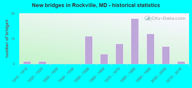
- New bridges - historical statistics
- 11910-1919
- 11920-1929
- 111950-1959
- 41960-1969
- 81970-1979
- 181980-1989
- 121990-1999
- 72000-2009
- 12010-2019

- Reconstructed bridges - Historical Statistics
- 11960-1969
- 11970-1979
- 21980-1989
- 41990-1999
- 22000-2009
- 12010-2019


- Bridge Condition - Deck
- 40.6%Good
- 50.0%Satisfactory
- 9.4%Fair

- Bridge Condition - Superstructure
- 7.9%Very good
- 42.1%Good
- 31.6%Satisfactory
- 13.2%Fair
- 5.3%Poor

- Bridge Condition - Substructure
- 7.9%Very good
- 28.9%Good
- 50.0%Satisfactory
- 13.2%Fair

- Bridge Condition - Channel
- 14.7%Very good
- 32.4%Good
- 41.2%Satisfactory
- 11.8%Fair

- Bridge Condition - Culverts
- 42.9%Good
- 57.1%Satisfactory
Find on map >> Show street view
Structure Number: 200000M-R-1401, Location: 0.16 MI NORTH OF MD 28 (Lat: 39.083947, Lng: -77.148950), Route carried "on" structure: City street 2140, Year Built: 1996, Status: Open, Structure Length: 5.18m (16.99ft), Average Daily Traffic: 3,663 (year 2021), Truck Traffic: 2%, Average Future Daily Traffic: 4,057 (year 2041), Design Load: HS 20, Features Intersected: TRUCK STREET, Facility Carried by Structure: MONROE STREET
Minimum Vertical Clearance: 30+ m (98+ ft), Kilometerpoint: 0.000, Lanes on structure: 2, Owner: City or Municipal Highway Agency, Approaching Roadway Width: 13.4m (44.0ft), Material/Design: Steel, Design/Construction: Girder and Floorbeam System, Number Of Spans In Main Unit: 4, Length of Maximum Span: 10.1m (33.1ft), Curb or Sidewalk Widths: Left: 4.3m (14.1ft), Right: 4.3m (14.1ft), Curb-To-Curb Width: 8.5m (27.9ft), Out-to-Out Width: 16.2m (53.1ft)
Condition: Deck: Satisfactory, Superstructure: Good, Substructure: Satisfactory, Operating Rating: 76.2 metric tons, Method Used To Determine Operating Rating: Load Factor (LF), Inventory Rating: 45.4 metric tons, Method Used To Determine Inventory Rating: Load Factor (LF), Structural Evaluation: Equal to present minimum criteria, Deck Geometry: Meets minimum limits, Approach Roadway Alignment: Equal to present desirable criteria, Designated Inspection Frequency: Every 24 months, Critical Feature Inspection Frequency: Every 24 months, Inspection Date: August 2021, Critical Feature Inspection Date: August 2021, Deck Structure Type: Concrete Cast-file-Place, Wearing Surface/Protective System: Wearing Surface: Other, Deck Protection: Epoxy Coated Reinforcing
Find on map >> Show street view
Structure Number: 200000M-R-1502, Location: 1.1 MILES WEST MD 355 (Lat: 39.066558, Lng: -77.150975), Route carried "on" structure: City street 2593, Year Built: 1991, Status: Open, Structure Length: 2.01m (6.59ft), Average Daily Traffic: 20,825 (year 2017), Truck Traffic: 5%, Average Future Daily Traffic: 23,332 (year 2037), Features Intersected: CABIN JOHN CREEK, Facility Carried by Structure: WOOTTON PARKWAY
Minimum Vertical Clearance: 30+ m (98+ ft), Kilometerpoint: 0.000, Lanes on structure: 5, Owner: City or Municipal Highway Agency, Approaching Roadway Width: 18.9m (62.0ft), Material/Design: Concrete, Design/Construction: Culvert, Length of Maximum Span: 3.7m (12.1ft), Curb or Sidewalk Widths: Left: 1.2m (3.9ft), Right: 2.4m (7.9ft)
Condition: Channel: Good, Culverts: Satisfactory, Inventory Rating: 61.2 metric tons, Method Used To Determine Inventory Rating: Load Factor (LF), Structural Evaluation: Equal to present minimum criteria, Waterway Adequacy: Equal to present desirable criteria, Approach Roadway Alignment: Equal to present desirable criteria, Designated Inspection Frequency: Every 24 months, Inspection Date: August 2020
Find on map >> Show street view
Structure Number: 200000M-R-1602, Location: 1.1 MILES WEST OF MD 355 (Lat: 39.067339, Lng: -77.149297), Route carried "on" structure: City street 2593, Year Built: 1991, Status: Open, Structure Length: 0.88m (2.89ft), Average Daily Traffic: 20,825 (year 2017), Truck Traffic: 5%, Average Future Daily Traffic: 23,332 (year 2037), Design Load: HS 20, Features Intersected: TRIB CABIN JOHN CREEK, Facility Carried by Structure: WOOTTON PARKWAY
Minimum Vertical Clearance: 30+ m (98+ ft), Kilometerpoint: 0.000, Lanes on structure: 4, Owner: City or Municipal Highway Agency, Approaching Roadway Width: 15.9m (52.2ft), Skew: 3 degrees, Material/Design: Concrete, Design/Construction: Culvert, Length of Maximum Span: 3.7m (12.1ft), Curb or Sidewalk Widths: Left: 2.4m (7.9ft), Right: 0.0m
Condition: Channel: Satisfactory, Culverts: Satisfactory, Inventory Rating: 54.4 metric tons, Method Used To Determine Inventory Rating: Load Factor (LF), Structural Evaluation: Equal to present minimum criteria, Waterway Adequacy: Superior to present desirable criteria, Approach Roadway Alignment: Equal to present desirable criteria, Designated Inspection Frequency: Every 24 months, Inspection Date: August 2020
Find on map >> Show street view
Structure Number: 200000M-R-1701, Location: 0.5 Miles West of Md. 355 (Lat: 39.084047, Lng: -77.150919), Route carried "on" structure: Business City street 786, Year Built: 1998, Status: Open, Structure Length: 14.45m (47.41ft), Average Daily Traffic: 500 (year 2011), Truck Traffic: 5%, Average Future Daily Traffic: 1,000 (year 2031), Design Load: HS 20, Features Intersected: Rockville Center Multipl, Facility Carried by Structure: East Montgomery Ro
Minimum Vertical Clearance: 30+ m (98+ ft), Kilometerpoint: 0.000, Lanes on structure: 2, Owner: Private, Approaching Roadway Width: 14.0m (45.9ft), Material/Design: Prestressed concrete, Design/Construction: Box Beam or Girders - Multiple, Number Of Spans In Main Unit: 12, Length of Maximum Span: 15.2m (49.9ft), Curb or Sidewalk Widths: Left: 2.4m (7.9ft), Right: 2.4m (7.9ft), Curb-To-Curb Width: 12.8m (42.0ft), Out-to-Out Width: 22.3m (73.2ft)
Condition: Deck: Satisfactory, Superstructure: Good, Substructure: Good, Operating Rating: 38.1 metric tons, Method Used To Determine Operating Rating: Load Factor (LF), Inventory Rating: 18.1 metric tons, Method Used To Determine Inventory Rating: Load Factor (LF), Structural Evaluation: Somewhat better than minimum adequacy, Deck Geometry: Superior to present desirable criteria, Approach Roadway Alignment: Equal to present minimum criteria, Designated Inspection Frequency: Every 24 months, Inspection Date: March 2021, Deck Structure Type: Concrete Precast Panels
Find on map >> Show street view
Structure Number: 200000M-R-1801, Location: WOOTTONS MILL PARK (Lat: 39.081522, Lng: -77.179164), Route carried "on" structure: Other road , Year Built: 2009, Status: Posted for load, Structure Length: 1.83m (6.00ft), Average Daily Traffic: 22 (year 2021), Average Future Daily Traffic: 26 (year 2041), Features Intersected: WATTS BRANCH, Facility Carried by Structure: DRIVEWAY OFF AINTR
Minimum Vertical Clearance: 30+ m (98+ ft), Kilometerpoint: 0.000, Lanes on structure: 1, Owner: City or Municipal Highway Agency, Approaching Roadway Width: 3.7m (12.1ft), Material/Design: Prestressed concrete, Design/Construction: Box Beam or Girders - Multiple, Number Of Spans In Main Unit: 1, Length of Maximum Span: 18.3m (60.0ft), Curb-To-Curb Width: 4.5m (14.8ft), Out-to-Out Width: 5.5m (18.0ft)
Condition: Deck: Good, Superstructure: Very good, Substructure: Good, Channel: Good, Operating Rating: 83.0 metric tons, Method Used To Determine Operating Rating: Load Factor (LF), Inventory Rating: 49.4 metric tons, Method Used To Determine Inventory Rating: Load Factor (LF), Structural Evaluation: Better than present minimum criteria, Deck Geometry: Equal to present minimum criteria, Waterway Adequacy: Better than present minimum criteria, Approach Roadway Alignment: Equal to present desirable criteria, Designated Inspection Frequency: Every 24 months, Inspection Date: August 2021, Deck Structure Type: Concrete Cast-file-Place
Find on map >> Show street view
Structure Number: 200000M-R-1901, Location: 0.5M S OF MD 28 (Lat: 39.098561, Lng: -77.190364), Route carried "on" structure: County highway 1068, Year Built: 2003, Status: Open, Structure Length: 0.73m (2.40ft), Average Daily Traffic: 5,504 (year 2019), Truck Traffic: 5%, Average Future Daily Traffic: 7,382 (year 2039), Design Load: HS 20, Features Intersected: TRIBUTARY TO WATTS BRANC, Facility Carried by Structure: FALLSGROVE DRIVE
Minimum Vertical Clearance: 30+ m (98+ ft), Kilometerpoint: 0.000, Lanes on structure: 3, Owner: City or Municipal Highway Agency, Approaching Roadway Width: 11.3m (37.1ft), Material/Design: Steel, Design/Construction: Arch - Deck, Number Of Spans In Main Unit: 1, Length of Maximum Span: 7.3m (24.0ft), Curb or Sidewalk Widths: Left: 2.1m (6.9ft), Right: 2.4m (7.9ft), Curb-To-Curb Width: 91.4m (299.9ft), Out-to-Out Width: 91.4m (299.9ft)
Condition: Superstructure: Satisfactory, Substructure: Very good, Channel: Good, Structural Evaluation: Equal to present minimum criteria, Deck Geometry: Superior to present desirable criteria, Waterway Adequacy: Equal to present desirable criteria, Approach Roadway Alignment: Equal to present desirable criteria, Designated Inspection Frequency: Every 24 months, Inspection Date: November 2020
Find on map >> Show street view
Structure Number: 200000M-R-2001, Location: 0.2 MI E OF TOWER OAKS BL (Lat: 39.061547, Lng: -77.152392), Route carried "on" structure: County highway 2468, Year Built: 2006, Status: Open, Structure Length: 1.31m (4.30ft), Average Daily Traffic: 2,340 (year 2019), Truck Traffic: 3%, Average Future Daily Traffic: 3,068 (year 2039), Design Load: HS 20, Features Intersected: CABIN JOHN CREEK, Facility Carried by Structure: PRESERVE PARKWAY
Minimum Vertical Clearance: 30+ m (98+ ft), Kilometerpoint: 0.000, Lanes on structure: 4, Owner: City or Municipal Highway Agency, Approaching Roadway Width: 12.8m (42.0ft), Material/Design: Concrete, Design/Construction: Arch - Deck, Number Of Spans In Main Unit: 1, Length of Maximum Span: 13.1m (43.0ft), Curb or Sidewalk Widths: Left: 2.4m (7.9ft), Right: 1.2m (3.9ft), Curb-To-Curb Width: 91.4m (299.9ft), Out-to-Out Width: 91.4m (299.9ft)
Condition: Superstructure: Satisfactory, Substructure: Good, Channel: Good, Inventory Rating: 73.9 metric tons, Method Used To Determine Inventory Rating: Load Factor (LF), Structural Evaluation: Equal to present minimum criteria, Deck Geometry: Superior to present desirable criteria, Waterway Adequacy: Equal to present desirable criteria, Approach Roadway Alignment: Equal to present desirable criteria, Designated Inspection Frequency: Every 24 months, Inspection Date: November 2020
Find on map >> Show street view
Structure Number: 200000M-R-2202, Location: 0.1M S OF WOOTTON PKWY (Lat: 39.066697, Lng: -77.150306), Route carried "on" structure: County highway 2468, Year Built: 1999, Status: Open, Structure Length: 0.82m (2.69ft), Average Daily Traffic: 2,720 (year 2019), Truck Traffic: 1%, Average Future Daily Traffic: 3,560 (year 2039), Design Load: HS 20, Features Intersected: TRIBUTARY TO CABIN JOHN, Facility Carried by Structure: PRESERVE PARKWAY
Minimum Vertical Clearance: 30+ m (98+ ft), Kilometerpoint: 0.000, Lanes on structure: 4, Owner: City or Municipal Highway Agency, Approaching Roadway Width: 13.7m (44.9ft), Material/Design: Concrete, Design/Construction: Culvert, Length of Maximum Span: 4.3m (14.1ft), Curb or Sidewalk Widths: Left: 2.4m (7.9ft), Right: 1.2m (3.9ft)
Condition: Channel: Very good, Culverts: Good, Operating Rating: 79.4 metric tons, Method Used To Determine Operating Rating: Load Factor (LF), Inventory Rating: 47.6 metric tons, Method Used To Determine Inventory Rating: Load Factor (LF), Structural Evaluation: Better than present minimum criteria, Waterway Adequacy: Equal to present desirable criteria, Approach Roadway Alignment: Equal to present minimum criteria, Designated Inspection Frequency: Every 24 months, Inspection Date: November 2020
Find on map >> Show street view
Structure Number: 200000M-R-2302, Location: 0.1 M N OF MONTROSE ROAD (Lat: 39.058056, Lng: -77.151769), Route carried "on" structure: City street 2934, Year Built: 1975, Status: Open, Structure Length: 0.98m (3.22ft), Average Daily Traffic: 12,130 (year 2017), Truck Traffic: 3%, Average Future Daily Traffic: 16,300 (year 2030), Features Intersected: CABIN JOHN CREEK, Facility Carried by Structure: TOWER OAKS BOULEVA
Minimum Vertical Clearance: 30+ m (98+ ft), Kilometerpoint: 0.000, Lanes on structure: 4, Owner: City or Municipal Highway Agency, Approaching Roadway Width: 13.4m (44.0ft), Skew: 3 degrees, Material/Design: Concrete, Design/Construction: Culvert, Number Of Spans In Main Unit: 3, Length of Maximum Span: 3.0m (9.8ft), Curb or Sidewalk Widths: Left: 2.4m (7.9ft), Right: 2.4m (7.9ft), Curb-To-Curb Width: 13.4m (44.0ft), Out-to-Out Width: 20.7m (67.9ft)
Condition: Channel: Fair, Culverts: Good, Operating Rating: 32.7 metric tons, Method Used To Determine Operating Rating: Field evaluation and documented engineering judgment, Inventory Rating: 32.7 metric tons, Method Used To Determine Inventory Rating: Field evaluation and documented engineering judgment, Structural Evaluation: Better than present minimum criteria, Deck Geometry: High priority of replacement, Waterway Adequacy: Better than present minimum criteria, Approach Roadway Alignment: Equal to present desirable criteria, Length Of Structure Improvement: 0.98m (3.22ft), Designated Inspection Frequency: Every 24 months, Inspection Date: June 2020, Bridge Improvement Cost: $5,000, Roadway Improvement Cost: $1,000, Total Project Cost: $6,000
Find on map >> Show street view
Structure Number: 200000M-R-2401, Location: 0.07 MILE WEST OF MD28 (Lat: 39.155203, Lng: -8.193200), Route carried "on" structure: City street , Year Built: 2017, Status: Open, Structure Length: 0.76m (2.49ft), Average Daily Traffic: 3,496 (year 2021), Truck Traffic: 4%, Average Future Daily Traffic: 3,916 (year 2041), Features Intersected: ROCK CREEK TRIBUTARY, Facility Carried by Structure: FIRST STREET
Minimum Vertical Clearance: 30+ m (98+ ft), Kilometerpoint: 0.000, Lanes on structure: 2, Owner: City or Municipal Highway Agency, Approaching Roadway Width: 8.5m (27.9ft), Skew: 2 degrees, Material/Design: Prestressed concrete, Design/Construction: Slab, Number Of Spans In Main Unit: 1, Length of Maximum Span: 7.6m (24.9ft), Curb or Sidewalk Widths: Left: 1.7m (5.6ft), Right: 1.4m (4.6ft), Curb-To-Curb Width: 85.3m (279.9ft), Out-to-Out Width: 128.0m (419.9ft)
Condition: Deck: Good, Superstructure: Very good, Substructure: Very good, Channel: Good, Operating Rating: 96.9 metric tons, Method Used To Determine Operating Rating: Load and Resistance Factor Rating (LRFR) rating reported by rating factor(RF) method using HL-93 loadings, Inventory Rating: 64.8 metric tons, Method Used To Determine Inventory Rating: Load and Resistance Factor Rating (LRFR) rating reported by rating factor(RF) method using HL-93 loadings, Structural Evaluation: Equal to present desirable criteria, Deck Geometry: Superior to present desirable criteria, Waterway Adequacy: Superior to present desirable criteria, Approach Roadway Alignment: Equal to present desirable criteria, Designated Inspection Frequency: Every 24 months, Inspection Date: December 2021, Deck Structure Type: Concrete Cast-file-Place, Wearing Surface/Protective System: Wearing Surface: Integral Concrete
Find on map >> Show street view
Structure Number: 10000015004701, Location: 0.93 MILE SOUTH OF IS 370 (Lat: 39.110158, Lng: -77.187739), Route carried "under" structure: ServiceInterstate 270, Year Built: 1987, Structure Length: 0. m, Average Daily Traffic: 36,198 (year 2006), Truck Traffic: 8%, Features Intersected: IS 270 SB C-D ROAD, Facility Carried by Structure: SHADY GROVE ROAD
Minimum Vertical Clearance: 4.88m (16.01ft), Kilometerpoint: 13.500, Lanes on structure: 8, Lanes under structure: 3, Material/Design: Steel continuous, Design/Construction: Stringer/Multi-beam, Length of Maximum Span: 26.5m (86.9ft)
Find on map >> Show street view
Structure Number: 10000015004701, Location: 0.93 MILE SOUTH OF IS 370 (Lat: 39.110158, Lng: -77.187739), Route carried "under" structure: ServiceInterstate 270, Year Built: 1987, Structure Length: 0. m, Average Daily Traffic: 36,198 (year 2006), Truck Traffic: 8%, Features Intersected: IS 270 NB C-D ROAD, Facility Carried by Structure: SHADY GROVE ROAD
Minimum Vertical Clearance: 4.88m (16.01ft), Kilometerpoint: 13.500, Lanes on structure: 8, Lanes under structure: 3, Material/Design: Steel continuous, Design/Construction: Stringer/Multi-beam, Length of Maximum Span: 26.5m (86.9ft)
Find on map >> Show street view
Structure Number: 10000015004701, Location: 0.93 MILE SOUTH OF IS 370 (Lat: 39.110158, Lng: -77.187739), Route carried "under" structure: Interstate 270, Year Built: 1987, Structure Length: 0. m, Average Daily Traffic: 146,985 (year 2006), Truck Traffic: 8%, Features Intersected: IS 270, Facility Carried by Structure: SHADY GROVE ROAD
Minimum Vertical Clearance: 4.88m (16.01ft), Kilometerpoint: 13.500, Lanes on structure: 8, Lanes under structure: 8, Material/Design: Steel continuous, Design/Construction: Stringer/Multi-beam, Length of Maximum Span: 26.5m (86.9ft)
Find on map >> Show street view
Structure Number: 10000015004801, Location: 0.96 MILE NORTH OF MD 189 (Lat: 39.085925, Lng: -77.173811), Route carried "under" structure: ServiceInterstate 270, Year Built: 1955, Structure Length: 0. m, Average Daily Traffic: 27,892 (year 2006), Truck Traffic: 8%, Features Intersected: IS 270 NB C-D ROAD, Facility Carried by Structure: MD 28
Minimum Vertical Clearance: 4.57m (14.99ft), Kilometerpoint: 10.394, Lanes on structure: 6, Lanes under structure: 3, Material/Design: Steel, Design/Construction: Stringer/Multi-beam, Length of Maximum Span: 24.7m (81.0ft)
Find on map >> Show street view
Structure Number: 10000015004801, Location: 0.96 MILE NORTH OF MD 189 (Lat: 39.085925, Lng: -77.173811), Route carried "under" structure: ServiceInterstate 270, Year Built: 1955, Structure Length: 0. m, Average Daily Traffic: 27,892 (year 2006), Truck Traffic: 8%, Features Intersected: IS 270 SB C-D ROAD, Facility Carried by Structure: MD 28
Minimum Vertical Clearance: 4.57m (14.99ft), Kilometerpoint: 10.394, Lanes on structure: 6, Lanes under structure: 2, Material/Design: Steel, Design/Construction: Stringer/Multi-beam, Length of Maximum Span: 24.7m (81.0ft)
Find on map >> Show street view
Structure Number: 10000015004801, Location: 0.96 MILE NORTH OF MD 189 (Lat: 39.085925, Lng: -77.173811), Route carried "under" structure: Interstate 270, Year Built: 1955, Structure Length: 0. m, Average Daily Traffic: 185,579 (year 2006), Truck Traffic: 8%, Features Intersected: IS 270, Facility Carried by Structure: MD 28
Minimum Vertical Clearance: 4.88m (16.01ft), Kilometerpoint: 10.394, Lanes on structure: 6, Lanes under structure: 8, Material/Design: Steel, Design/Construction: Stringer/Multi-beam, Length of Maximum Span: 24.7m (81.0ft)
Find on map >> Show street view
Structure Number: 10000015004901, Location: 0.96 MILE SOUTH OF MD 28 (Lat: 39.073633, Lng: -77.164703), Route carried "under" structure: ServiceInterstate 270, Year Built: 1988, Structure Length: 0. m, Average Daily Traffic: 30,038 (year 2006), Truck Traffic: 8%, Features Intersected: IS 270 SB C-D ROAD, Facility Carried by Structure: MD 189
Minimum Vertical Clearance: 5.49m (18.01ft), Kilometerpoint: 8.850, Lanes on structure: 6, Lanes under structure: 2, Material/Design: Steel continuous, Design/Construction: Stringer/Multi-beam, Length of Maximum Span: 22.9m (75.1ft)
Find on map >> Show street view
Structure Number: 10000015004901, Location: 0.96 MILE SOUTH OF MD 28 (Lat: 39.073633, Lng: -77.164703), Route carried "under" structure: ServiceInterstate 270, Year Built: 1988, Structure Length: 0. m, Average Daily Traffic: 30,038 (year 2006), Truck Traffic: 8%, Features Intersected: IS 270 NB C-D ROAD, Facility Carried by Structure: MD 189
Minimum Vertical Clearance: 5.49m (18.01ft), Kilometerpoint: 8.850, Lanes on structure: 6, Lanes under structure: 2, Material/Design: Steel continuous, Design/Construction: Stringer/Multi-beam, Length of Maximum Span: 22.9m (75.1ft)
Find on map >> Show street view
Structure Number: 10000015004901, Location: 0.96 MILE SOUTH OF MD 28 (Lat: 39.073633, Lng: -77.164703), Route carried "under" structure: Interstate 270, Year Built: 1955, Structure Length: 0. m, Average Daily Traffic: 200,505 (year 2006), Truck Traffic: 8%, Features Intersected: IS 270, Facility Carried by Structure: MD 189
Minimum Vertical Clearance: 5.49m (18.01ft), Kilometerpoint: 8.850, Lanes on structure: 6, Lanes under structure: 8, Material/Design: Steel continuous, Design/Construction: Stringer/Multi-beam, Length of Maximum Span: 19.5m (64.0ft)
Find on map >> Show street view
Structure Number: 200000M-R-1101, Location: .35 MI EAST OF MD 28 (Lat: 0.651683, Lng: -1.286244), Route carried "under" structure: Interstate 270, Year Built: 1985, Structure Length: 0. m, Average Daily Traffic: 240,421 (year 2010), Truck Traffic: 7%, Features Intersected: I-270, Facility Carried by Structure: GUDE DRIVE WEST
Minimum Vertical Clearance: 4.88m (16.01ft), Kilometerpoint: 12.180, Lanes on structure: 4, Lanes under structure: 13, Material/Design: Steel continuous, Design/Construction: Stringer/Multi-beam, Length of Maximum Span: 38.1m (125.0ft)
Find on map >> Show street view
Structure Number: 200000M-R-1201, Location: 0.2 MI. E. SEVEN LOCKS RD (Lat: 0.651111, Lng: -1.285917), Route carried "under" structure: Interstate 270, Year Built: 1990, Structure Length: 0. m, Average Daily Traffic: 263,331 (year 2010), Truck Traffic: 7%, Features Intersected: I-270, Facility Carried by Structure: WOOTTON PARKWAY
Minimum Vertical Clearance: 5.18m (16.99ft), Kilometerpoint: 7.884, Lanes on structure: 4, Lanes under structure: 12, Material/Design: Steel continuous, Design/Construction: Stringer/Multi-beam, Length of Maximum Span: 50.3m (165.0ft)