Bridge Statistics for Rome, Georgia (GA)
Condition, Traffic, Stress, Structural Evaluation, Project Costs
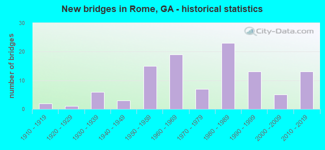
- New bridges - historical statistics
- 21910-1919
- 11920-1929
- 61930-1939
- 31940-1949
- 151950-1959
- 191960-1969
- 71970-1979
- 231980-1989
- 131990-1999
- 52000-2009
- 132010-2019

- Reconstructed bridges - Historical Statistics
- 21940-1949
- 01950-1959
- 11960-1969
- 11970-1979
- 71980-1989
- 41990-1999
- 12000-2009


- Bridge Condition - Deck
- 5.3%Very good
- 60.0%Good
- 25.3%Satisfactory
- 8.0%Fair
- 1.3%Poor

- Bridge Condition - Superstructure
- 18.7%Very good
- 64.0%Good
- 12.0%Satisfactory
- 5.3%Fair

- Bridge Condition - Substructure
- 1.3%Very good
- 74.7%Good
- 18.7%Satisfactory
- 4.0%Fair
- 1.3%Poor

- Bridge Condition - Channel
- 2.5%Excellent
- 61.7%Very good
- 18.5%Good
- 9.9%Satisfactory
- 7.4%Fair

- Bridge Condition - Culverts
- 65.6%Good
- 21.9%Satisfactory
- 9.4%Fair
- 3.1%Poor
Find on map >> Show street view
Structure Number: 1155059, Location: IN WEST ROME (Lat: 34.264539, Lng: -85.213719), Route carried "on" structure: City street 813, Year Built: 1988, Status: Open, Structure Length: 0.73m (2.40ft), Average Daily Traffic: 1,250 (year 2012), Truck Traffic: 1%, Average Future Daily Traffic: 1,875 (year 2032), Design Load: HS 20+Mod, Features Intersected: HORSELEG CREEK, Facility Carried by Structure: PARIS DRIVE
Minimum Vertical Clearance: 30+ m (98+ ft), Kilometerpoint: 0.000, Lanes on structure: 2, Base Highway Network: Yes, Owner: City or Municipal Highway Agency, Approaching Roadway Width: 6.7m (22.0ft), Skew: 1 degrees, Material/Design: Concrete, Design/Construction: Culvert, Number Of Spans In Main Unit: 3, Length of Maximum Span: 2.1m (6.9ft)
Condition: Channel: Fair, Culverts: Satisfactory, Operating Rating: 55.3 metric tons, Method Used To Determine Operating Rating: Field evaluation and documented engineering judgment, Inventory Rating: 32.6 metric tons, Method Used To Determine Inventory Rating: Field evaluation and documented engineering judgment, Structural Evaluation: Equal to present minimum criteria, Waterway Adequacy: Superior to present desirable criteria, Approach Roadway Alignment: Better than present minimum criteria, Designated Inspection Frequency: Every 24 months, Inspection Date: September 2021, Bridge Improvement Cost: $94,000, Roadway Improvement Cost: $9,000, Total Project Cost: $141,000
Find on map >> Show street view
Structure Number: 115506, Location: IN EAST ROME (Lat: 34.250500, Lng: -85.133378), Route carried "on" structure: City street 996, Year Built: 1978, Status: Open, Structure Length: 0.98m (3.22ft), Average Daily Traffic: 1,150 (year 2012), Truck Traffic: 1%, Average Future Daily Traffic: 1,725 (year 2032), Design Load: HS 20+Mod, Features Intersected: ETOWAH RIVER TRIB., Facility Carried by Structure: VALLEY BROOK ROAD
Minimum Vertical Clearance: 30+ m (98+ ft), Kilometerpoint: 0.000, Lanes on structure: 2, Base Highway Network: Yes, Owner: City or Municipal Highway Agency, Approaching Roadway Width: 11.0m (36.1ft), Material/Design: Concrete, Design/Construction: Culvert, Number Of Spans In Main Unit: 3, Length of Maximum Span: 3.0m (9.8ft)
Condition: Channel: Very good, Culverts: Good, Operating Rating: 55.3 metric tons, Method Used To Determine Operating Rating: Field evaluation and documented engineering judgment, Inventory Rating: 32.6 metric tons, Method Used To Determine Inventory Rating: Field evaluation and documented engineering judgment, Structural Evaluation: Better than present minimum criteria, Waterway Adequacy: Superior to present desirable criteria, Approach Roadway Alignment: Equal to present desirable criteria, Designated Inspection Frequency: Every 24 months, Inspection Date: September 2021, Bridge Improvement Cost: $125,000, Roadway Improvement Cost: $13,000, Total Project Cost: $188,000
Find on map >> Show street view
Structure Number: 1155064, Location: 5 MI N OF COOSA (Lat: 34.325128, Lng: -85.326358), Route carried "on" structure: County highway 246, Year Built: 1982, Status: Open, Structure Length: 0.82m (2.69ft), Average Daily Traffic: 490 (year 2012), Truck Traffic: 1%, Average Future Daily Traffic: 735 (year 2032), Design Load: H 15, Features Intersected: HEATH CREEK, Facility Carried by Structure: FOUCH GAP ROAD
Minimum Vertical Clearance: 30+ m (98+ ft), Kilometerpoint: 4.828, Lanes on structure: 2, Base Highway Network: Yes, Owner: County Highway Agency, Approaching Roadway Width: 6.4m (21.0ft), Skew: 3 degrees, Material/Design: Steel, Design/Construction: Culvert, Number Of Spans In Main Unit: 3, Length of Maximum Span: 2.1m (6.9ft)
Condition: Channel: Fair, Culverts: Poor, Operating Rating: 41.7 metric tons, Method Used To Determine Operating Rating: Field evaluation and documented engineering judgment, Inventory Rating: 24.4 metric tons, Method Used To Determine Inventory Rating: Field evaluation and documented engineering judgment, Structural Evaluation: Meets minimum limits, Waterway Adequacy: Superior to present desirable criteria, Approach Roadway Alignment: Equal to present desirable criteria, Designated Inspection Frequency: Every 24 months, Inspection Date: September 2021, Bridge Improvement Cost: $105,000, Roadway Improvement Cost: $11,000, Total Project Cost: $158,000
Find on map >> Show street view
Structure Number: 1155067, Location: 5.2 MI E OF ROME (Lat: 34.257697, Lng: -85.082489), Route carried "on" structure: County highway 121, Year Built: 1987, Status: Open, Structure Length: 2.13m (6.99ft), Average Daily Traffic: 490 (year 2012), Truck Traffic: 1%, Average Future Daily Traffic: 735 (year 2032), Design Load: HS 20+Mod, Features Intersected: DYKES CREEK, Facility Carried by Structure: FRED KELLEY ROAD
Minimum Vertical Clearance: 30+ m (98+ ft), Kilometerpoint: 0.000, Lanes on structure: 2, Base Highway Network: Yes, Owner: County Highway Agency, Approaching Roadway Width: 6.1m (20.0ft), Material/Design: Concrete, Design/Construction: Culvert, Number Of Spans In Main Unit: 6, Length of Maximum Span: 3.0m (9.8ft)
Condition: Channel: Very good, Culverts: Fair, Operating Rating: 55.3 metric tons, Method Used To Determine Operating Rating: Field evaluation and documented engineering judgment, Inventory Rating: 32.6 metric tons, Method Used To Determine Inventory Rating: Field evaluation and documented engineering judgment, Structural Evaluation: Somewhat better than minimum adequacy, Waterway Adequacy: Superior to present desirable criteria, Approach Roadway Alignment: Equal to present desirable criteria, Designated Inspection Frequency: Every 24 months, Inspection Date: November 2021, Bridge Improvement Cost: $274,000, Roadway Improvement Cost: $27,000, Total Project Cost: $410,000
Find on map >> Show street view
Structure Number: 1155068, Location: IN WEST ROME (Lat: 34.278647, Lng: -85.263031), Route carried "on" structure: City street 1099, Year Built: 1990, Status: Open, Structure Length: 1.43m (4.69ft), Average Daily Traffic: 930 (year 2012), Truck Traffic: 1%, Average Future Daily Traffic: 1,395 (year 2032), Design Load: HS 20+Mod, Features Intersected: BEECH CREEK, Facility Carried by Structure: GARDEN LAKES PWY
Minimum Vertical Clearance: 30+ m (98+ ft), Kilometerpoint: 1.609, Lanes on structure: 4, Base Highway Network: Yes, Owner: City or Municipal Highway Agency, Approaching Roadway Width: 14.6m (47.9ft), Skew: 10 degrees, Material/Design: Concrete, Design/Construction: Culvert, Number Of Spans In Main Unit: 4, Length of Maximum Span: 3.0m (9.8ft)
Condition: Channel: Very good, Culverts: Good, Operating Rating: 55.3 metric tons, Method Used To Determine Operating Rating: Field evaluation and documented engineering judgment, Inventory Rating: 32.6 metric tons, Method Used To Determine Inventory Rating: Field evaluation and documented engineering judgment, Structural Evaluation: Better than present minimum criteria, Waterway Adequacy: Superior to present desirable criteria, Approach Roadway Alignment: Equal to present desirable criteria, Designated Inspection Frequency: Every 24 months, Inspection Date: August 2021, Bridge Improvement Cost: $284,000, Roadway Improvement Cost: $28,000, Total Project Cost: $426,000
Find on map >> Show street view
Structure Number: 1155071, Location: IN NW ROME (Lat: 34.296158, Lng: -85.211358), Route carried "on" structure: City street 3758, Year Built: 1996, Status: Open, Structure Length: 1.65m (5.41ft), Average Daily Traffic: 2,160 (year 2012), Truck Traffic: 1%, Average Future Daily Traffic: 3,240 (year 2032), Design Load: HS 20+Mod, Features Intersected: LITTLE DRY CREEK, Facility Carried by Structure: TECHNOLOGY PKY
Minimum Vertical Clearance: 30+ m (98+ ft), Kilometerpoint: 6.437, Lanes on structure: 4, Base Highway Network: Yes, Owner: City or Municipal Highway Agency, Approaching Roadway Width: 15.8m (51.8ft), Material/Design: Concrete, Design/Construction: Culvert, Number Of Spans In Main Unit: 5, Length of Maximum Span: 3.0m (9.8ft)
Condition: Channel: Good, Culverts: Good, Operating Rating: 55.3 metric tons, Method Used To Determine Operating Rating: Field evaluation and documented engineering judgment, Inventory Rating: 32.6 metric tons, Method Used To Determine Inventory Rating: Field evaluation and documented engineering judgment, Structural Evaluation: Better than present minimum criteria, Waterway Adequacy: Superior to present desirable criteria, Approach Roadway Alignment: Equal to present desirable criteria, Designated Inspection Frequency: Every 24 months, Underwater Inspection Frequency: Every 60 months, Inspection Date: August 2021, Underwater Inspection Date: June 2019, Bridge Improvement Cost: $326,000, Roadway Improvement Cost: $33,000, Total Project Cost: $489,000
Find on map >> Show street view
Structure Number: 1155072, Location: IN NW ROME (Lat: 34.280500, Lng: -85.264378), Route carried "on" structure: City street 1165, Year Built: 1996, Status: Open, Structure Length: 1.01m (3.31ft), Average Daily Traffic: 10 (year 2012), Truck Traffic: 1%, Average Future Daily Traffic: 15 (year 2032), Design Load: HS 20+Mod, Features Intersected: BEECH CREEK, Facility Carried by Structure: FOX CROFT ROAD
Minimum Vertical Clearance: 30+ m (98+ ft), Kilometerpoint: 0.000, Lanes on structure: 2, Base Highway Network: Yes, Owner: City or Municipal Highway Agency, Approaching Roadway Width: 7.9m (25.9ft), Skew: 1 degrees, Material/Design: Concrete, Design/Construction: Culvert, Number Of Spans In Main Unit: 3, Length of Maximum Span: 3.0m (9.8ft)
Condition: Channel: Very good, Culverts: Good, Operating Rating: 55.3 metric tons, Method Used To Determine Operating Rating: Field evaluation and documented engineering judgment, Inventory Rating: 32.6 metric tons, Method Used To Determine Inventory Rating: Field evaluation and documented engineering judgment, Structural Evaluation: Better than present minimum criteria, Waterway Adequacy: Superior to present desirable criteria, Approach Roadway Alignment: Equal to present desirable criteria, Designated Inspection Frequency: Every 24 months, Inspection Date: August 2021, Bridge Improvement Cost: $129,000, Roadway Improvement Cost: $13,000, Total Project Cost: $193,000
Find on map >> Show street view
Structure Number: 1155073, Location: 5.1 MI W OF ROME (Lat: 34.243719, Lng: -85.263558), Route carried "on" structure: County highway 3707, Year Built: 1997, Status: Open, Structure Length: 1.19m (3.90ft), Average Daily Traffic: 1,730 (year 2012), Truck Traffic: 6%, Average Future Daily Traffic: 2,595 (year 2032), Design Load: HS 20, Features Intersected: FUNDERBUCK CREEK, Facility Carried by Structure: BURNETT FERRY ROAD
Minimum Vertical Clearance: 30+ m (98+ ft), Kilometerpoint: 4.828, Lanes on structure: 2, Base Highway Network: Yes, Owner: County Highway Agency, Approaching Roadway Width: 6.7m (22.0ft), Skew: 4 degrees, Material/Design: Concrete, Design/Construction: Culvert, Number Of Spans In Main Unit: 4, Length of Maximum Span: 2.7m (8.9ft)
Condition: Channel: Very good, Culverts: Satisfactory, Operating Rating: 55.3 metric tons, Method Used To Determine Operating Rating: Field evaluation and documented engineering judgment, Inventory Rating: 32.6 metric tons, Method Used To Determine Inventory Rating: Field evaluation and documented engineering judgment, Structural Evaluation: Equal to present minimum criteria, Waterway Adequacy: Superior to present desirable criteria, Approach Roadway Alignment: Equal to present desirable criteria, Designated Inspection Frequency: Every 24 months, Inspection Date: September 2021, Bridge Improvement Cost: $152,000, Roadway Improvement Cost: $15,000, Total Project Cost: $229,000
Find on map >> Show street view
Structure Number: 1155076, Location: IN EAST ROME (Lat: 34.257367, Lng: -85.123944), Route carried "on" structure: State highway 293, Year Built: 1997, Status: Open, Structure Length: 0.94m (3.08ft), Average Daily Traffic: 7,400 (year 2012), Truck Traffic: 1%, Average Future Daily Traffic: 11,100 (year 2032), Design Load: HS 20, Features Intersected: ETOWAH RIVER TRIB.
Minimum Vertical Clearance: 30+ m (98+ ft), Kilometerpoint: 9.656, Lanes on structure: 4, Base Highway Network: Yes, Owner: State Highway Agency, Approaching Roadway Width: 17.1m (56.1ft), Skew: 25 degrees, Material/Design: Concrete, Design/Construction: Culvert, Number Of Spans In Main Unit: 2, Length of Maximum Span: 4.6m (15.1ft)
Condition: Channel: Very good, Culverts: Good, Inventory Rating: 94.3 metric tons, Method Used To Determine Inventory Rating: Load Factor (LF), Structural Evaluation: Better than present minimum criteria, Waterway Adequacy: Superior to present desirable criteria, Approach Roadway Alignment: Equal to present desirable criteria, Designated Inspection Frequency: Every 24 months, Inspection Date: September 2021, Bridge Improvement Cost: $187,000, Roadway Improvement Cost: $19,000, Total Project Cost: $281,000
Find on map >> Show street view
Structure Number: 1155079, Location: 9.8 MI N OF ROME (Lat: 34.394739, Lng: -85.196469), Route carried "on" structure: US 27, Year Built: 1998, Status: Open, Structure Length: 10.97m (35.99ft), Average Daily Traffic: 10,700 (year 2012), Truck Traffic: 10%, Average Future Daily Traffic: 16,050 (year 2032), Design Load: HS 20+Mod, Features Intersected: ARMUCHEE CREEK
Minimum Vertical Clearance: 30+ m (98+ ft), Kilometerpoint: 38.624, Lanes on structure: 2, Base Highway Network: Yes, Owner: State Highway Agency, Approaching Roadway Width: 8.5m (27.9ft), Skew: 10 degrees, Material/Design: Prestressed concrete, Design/Construction: Stringer/Multi-beam, Number Of Spans In Main Unit: 4, Length of Maximum Span: 27.4m (89.9ft), Curb-To-Curb Width: 11.6m (38.1ft), Out-to-Out Width: 12.6m (41.3ft)
Condition: Deck: Good, Superstructure: Very good, Substructure: Good, Channel: Very good, Operating Rating: 80.7 metric tons, Method Used To Determine Operating Rating: Load Factor (LF), Inventory Rating: 29.9 metric tons, Method Used To Determine Inventory Rating: Load Factor (LF), Structural Evaluation: Better than present minimum criteria, Deck Geometry: Better than present minimum criteria, Waterway Adequacy: Superior to present desirable criteria, Approach Roadway Alignment: Equal to present desirable criteria, Designated Inspection Frequency: Every 24 months, Inspection Date: August 2021, Bridge Improvement Cost: $1,407,000, Roadway Improvement Cost: $141,000, Total Project Cost: $2,110,000, Deck Structure Type: Concrete Cast-file-Place
Find on map >> Show street view
Structure Number: 1155082, Location: IN NW ROME (Lat: 34.299019, Lng: -85.261228), Route carried "on" structure: City street 3758, Year Built: 2001, Status: Open, Structure Length: 0.64m (2.10ft), Average Daily Traffic: 1,090 (year 2012), Truck Traffic: 1%, Average Future Daily Traffic: 1,635 (year 2032), Design Load: HS 20+Mod, Features Intersected: BEECH CREEK, Facility Carried by Structure: TECHNOLOGY PKWY
Minimum Vertical Clearance: 30+ m (98+ ft), Kilometerpoint: 1.609, Lanes on structure: 4, Base Highway Network: Yes, Owner: City or Municipal Highway Agency, Approaching Roadway Width: 17.1m (56.1ft), Skew: 10 degrees, Material/Design: Concrete, Design/Construction: Culvert, Number Of Spans In Main Unit: 2, Length of Maximum Span: 3.0m (9.8ft)
Condition: Channel: Very good, Culverts: Good, Operating Rating: 55.3 metric tons, Method Used To Determine Operating Rating: Field evaluation and documented engineering judgment, Inventory Rating: 32.6 metric tons, Method Used To Determine Inventory Rating: Field evaluation and documented engineering judgment, Structural Evaluation: Better than present minimum criteria, Waterway Adequacy: Superior to present desirable criteria, Approach Roadway Alignment: Equal to present desirable criteria, Designated Inspection Frequency: Every 24 months, Underwater Inspection Frequency: Every 60 months, Inspection Date: August 2021, Underwater Inspection Date: August 2021, Bridge Improvement Cost: $127,000, Roadway Improvement Cost: $13,000, Total Project Cost: $190,000
Find on map >> Show street view
Structure Number: 1155084, Location: IN SOUTH EAST ROME (Lat: 34.220958, Lng: -85.133878), Route carried "on" structure: County highway 640, Year Built: 2005, Status: Open, Structure Length: 0.67m (2.20ft), Average Daily Traffic: 760 (year 2012), Truck Traffic: 2%, Average Future Daily Traffic: 1,140 (year 2032), Design Load: HS 20+Mod, Features Intersected: ETOWAH RIVER TRIB, Facility Carried by Structure: CALLIER SPRGS RD
Minimum Vertical Clearance: 30+ m (98+ ft), Kilometerpoint: 17.703, Lanes on structure: 2, Base Highway Network: Yes, Owner: County Highway Agency, Approaching Roadway Width: 5.5m (18.0ft), Skew: 4 degrees, Material/Design: Concrete, Design/Construction: Culvert, Number Of Spans In Main Unit: 2, Length of Maximum Span: 3.0m (9.8ft), Curb or Sidewalk Widths: Left: 0.0m, Right: 1.5m (4.9ft)
Condition: Culverts: Good, Structural Evaluation: Better than present minimum criteria, Waterway Adequacy: Superior to present desirable criteria, Approach Roadway Alignment: Better than present minimum criteria, Designated Inspection Frequency: Every 24 months, Inspection Date: October 2021, Bridge Improvement Cost: $86,000, Roadway Improvement Cost: $9,000, Total Project Cost: $129,000
Find on map >> Show street view
Structure Number: 1155086, Location: IN NORTH ROME (Lat: 34.263700, Lng: -85.169742), Route carried "on" structure: City street 1184, Year Built: 2006, Status: Open, Structure Length: 6.10m (20.01ft), Average Daily Traffic: 12,170 (year 2012), Truck Traffic: 1%, Average Future Daily Traffic: 18,255 (year 2032), Design Load: HS 20+Mod, Features Intersected: BURWELL CREEK, Facility Carried by Structure: NORTH 7TH AVENUE
Minimum Vertical Clearance: 30+ m (98+ ft), Kilometerpoint: 1.609, Lanes on structure: 4, Base Highway Network: Yes, Owner: City or Municipal Highway Agency, Approaching Roadway Width: 17.1m (56.1ft), Skew: 20 degrees, Material/Design: Prestressed concrete, Design/Construction: Stringer/Multi-beam, Number Of Spans In Main Unit: 3, Length of Maximum Span: 30.5m (100.1ft), Curb or Sidewalk Widths: Left: 1.8m (5.9ft), Right: 1.8m (5.9ft), Curb-To-Curb Width: 21.9m (71.9ft), Out-to-Out Width: 26.3m (86.3ft)
Condition: Deck: Good, Superstructure: Very good, Substructure: Good, Channel: Fair, Operating Rating: 48.0 metric tons, Method Used To Determine Operating Rating: Load Factor (LF), Inventory Rating: 28.1 metric tons, Method Used To Determine Inventory Rating: Load Factor (LF), Structural Evaluation: Better than present minimum criteria, Deck Geometry: Superior to present desirable criteria, Waterway Adequacy: Superior to present desirable criteria, Approach Roadway Alignment: Equal to present desirable criteria, Designated Inspection Frequency: Every 24 months, Inspection Date: August 2021, Bridge Improvement Cost: $1,208,000, Roadway Improvement Cost: $121,000, Total Project Cost: $1,812,000, Deck Structure Type: Concrete Cast-file-Place
Find on map >> Show street view
Structure Number: 1155088, Location: 6 MI NW OF ROME (Lat: 34.296539, Lng: -85.275128), Route carried "on" structure: County highway 647, Year Built: 2007, Status: Open, Structure Length: 0.64m (2.10ft), Average Daily Traffic: 760 (year 2012), Truck Traffic: 1%, Average Future Daily Traffic: 1,140 (year 2032), Design Load: HS 20+Mod, Features Intersected: SMITH CREEK TRIB, Facility Carried by Structure: HUFFAKER ROAD
Minimum Vertical Clearance: 30+ m (98+ ft), Kilometerpoint: 11.265, Lanes on structure: 2, Base Highway Network: Yes, Owner: County Highway Agency, Approaching Roadway Width: 9.1m (29.9ft), Material/Design: Concrete, Design/Construction: Culvert, Number Of Spans In Main Unit: 2, Length of Maximum Span: 3.0m (9.8ft)
Condition: Channel: Excellent, Culverts: Good, Operating Rating: 55.3 metric tons, Method Used To Determine Operating Rating: Field evaluation and documented engineering judgment, Inventory Rating: 32.6 metric tons, Method Used To Determine Inventory Rating: Field evaluation and documented engineering judgment, Structural Evaluation: Better than present minimum criteria, Waterway Adequacy: Superior to present desirable criteria, Approach Roadway Alignment: Equal to present desirable criteria, Designated Inspection Frequency: Every 24 months, Inspection Date: August 2021, Bridge Improvement Cost: $82,000, Roadway Improvement Cost: $8,000, Total Project Cost: $123,000
Find on map >> Show street view
Structure Number: 115509, Location: 6.1 MI S OF ROME (Lat: 34.165208, Lng: -85.205258), Route carried "on" structure: County highway 633, Year Built: 2008, Status: Open, Structure Length: 0.98m (3.22ft), Average Daily Traffic: 1,170 (year 2012), Truck Traffic: 1%, Average Future Daily Traffic: 1,755 (year 2032), Design Load: HS 20, Features Intersected: PRENTIS CREEK TRIB, Facility Carried by Structure: BOOZE MOUNTAIN RD
Minimum Vertical Clearance: 30+ m (98+ ft), Kilometerpoint: 0.000, Lanes on structure: 2, Base Highway Network: Yes, Owner: County Highway Agency, Approaching Roadway Width: 7.0m (23.0ft), Skew: 1 degrees, Material/Design: Concrete, Design/Construction: Culvert, Number Of Spans In Main Unit: 3, Length of Maximum Span: 3.0m (9.8ft)
Condition: Channel: Very good, Culverts: Good, Operating Rating: 55.3 metric tons, Method Used To Determine Operating Rating: Field evaluation and documented engineering judgment, Inventory Rating: 32.6 metric tons, Method Used To Determine Inventory Rating: Field evaluation and documented engineering judgment, Structural Evaluation: Better than present minimum criteria, Waterway Adequacy: Equal to present desirable criteria, Approach Roadway Alignment: Equal to present desirable criteria, Designated Inspection Frequency: Every 24 months, Inspection Date: September 2021, Bridge Improvement Cost: $125,000, Roadway Improvement Cost: $13,000, Total Project Cost: $188,000
Find on map >> Show street view
Structure Number: 1155101, Location: 3 MI NE OF ROME (Lat: 34.287256, Lng: -85.163247), Route carried "on" structure: Ramp County highway 5000, Year Built: 2011, Status: Open, Structure Length: 20.73m (68.01ft), Average Daily Traffic: 3,120 (year 2011), Truck Traffic: 4%, Average Future Daily Traffic: 4,680 (year 2031), Design Load: HS 20+Mod, Features Intersected: OOSTANAULA RIVER, Facility Carried by Structure: ARMUCHEE CONNECTOR
Minimum Vertical Clearance: 30+ m (98+ ft), Kilometerpoint: 0.000, Lanes on structure: 2, Owner: County Highway Agency, Approaching Roadway Width: 9.4m (30.8ft), Skew: 1 degrees, Material/Design: Prestressed concrete, Design/Construction: Stringer/Multi-beam, Number Of Spans In Main Unit: 5, Length of Maximum Span: 45.7m (149.9ft), Curb or Sidewalk Widths: Left: 3.7m (12.1ft), Right: 0.0m, Curb-To-Curb Width: 10.4m (34.1ft), Out-to-Out Width: 15.0m (49.2ft)
Condition: Deck: Good, Superstructure: Good, Substructure: Good, Channel: Very good, Operating Rating: 66.2 metric tons, Method Used To Determine Operating Rating: Load Factor (LF), Inventory Rating: 29.9 metric tons, Method Used To Determine Inventory Rating: Load Factor (LF), Structural Evaluation: Better than present minimum criteria, Deck Geometry: Better than present minimum criteria, Waterway Adequacy: Superior to present desirable criteria, Approach Roadway Alignment: Equal to present desirable criteria, Designated Inspection Frequency: Every 24 months, Inspection Date: August 2021, Bridge Improvement Cost: $2,657,000, Roadway Improvement Cost: $266,000, Total Project Cost: $3,985,000, Deck Structure Type: Concrete Cast-file-Place
Find on map >> Show street view
Structure Number: 1155102, Location: 3.2 MI NE OF ROME (Lat: 34.292764, Lng: -85.162661), Route carried "on" structure: Ramp County highway 5000, Year Built: 2011, Status: Open, Structure Length: 6.10m (20.01ft), Average Daily Traffic: 3,120 (year 2011), Truck Traffic: 4%, Average Future Daily Traffic: 4,680 (year 2031), Design Load: HS 20+Mod, Features Intersected: OOSTANAULA RIVER O/F, Facility Carried by Structure: ARMUCHEE CONNECTOR
Minimum Vertical Clearance: 30+ m (98+ ft), Kilometerpoint: 1.609, Lanes on structure: 2, Owner: County Highway Agency, Approaching Roadway Width: 11.0m (36.1ft), Material/Design: Prestressed concrete, Design/Construction: Stringer/Multi-beam, Number Of Spans In Main Unit: 5, Length of Maximum Span: 12.2m (40.0ft), Curb-To-Curb Width: 12.2m (40.0ft), Out-to-Out Width: 13.4m (44.0ft)
Condition: Deck: Good, Superstructure: Very good, Substructure: Very good, Channel: Very good, Operating Rating: 66.2 metric tons, Method Used To Determine Operating Rating: Load Factor (LF), Inventory Rating: 39.9 metric tons, Method Used To Determine Inventory Rating: Load Factor (LF), Structural Evaluation: Equal to present desirable criteria, Deck Geometry: Superior to present desirable criteria, Waterway Adequacy: Equal to present desirable criteria, Approach Roadway Alignment: Equal to present desirable criteria, Designated Inspection Frequency: Every 24 months, Inspection Date: August 2021, Bridge Improvement Cost: $781,000, Roadway Improvement Cost: $78,000, Total Project Cost: $1,172,000, Deck Structure Type: Concrete Cast-file-Place
Find on map >> Show street view
Structure Number: 1155105, Location: 6.5 M W OF ROME (Lat: 34.216297, Lng: -85.281400), Route carried "on" structure: Bypass State highway 1, Year Built: 2015, Status: Open, Structure Length: 5.79m (19.00ft), Average Daily Traffic: 4,110 (year 2012), Truck Traffic: 1%, Average Future Daily Traffic: 3,375 (year 2032), Design Load: HS 20+Mod, Features Intersected: MOUNTAIN END LAKE
Minimum Vertical Clearance: 30+ m (98+ ft), Kilometerpoint: 8.047, Lanes on structure: 2, Base Highway Network: Yes, Owner: State Highway Agency, Approaching Roadway Width: 7.0m (23.0ft), Skew: 3 degrees, Material/Design: Prestressed concrete, Design/Construction: Stringer/Multi-beam, Number Of Spans In Main Unit: 3, Length of Maximum Span: 24.4m (80.1ft), Curb-To-Curb Width: 11.6m (38.1ft), Out-to-Out Width: 12.6m (41.3ft)
Condition: Deck: Good, Superstructure: Very good, Substructure: Good, Channel: Excellent, Operating Rating: 70.7 metric tons, Method Used To Determine Operating Rating: Load Factor (LF), Inventory Rating: 39.0 metric tons, Method Used To Determine Inventory Rating: Load Factor (LF), Structural Evaluation: Better than present minimum criteria, Deck Geometry: Better than present minimum criteria, Waterway Adequacy: Superior to present desirable criteria, Approach Roadway Alignment: Equal to present desirable criteria, Length Of Structure Improvement: 6.95m (22.80ft), Designated Inspection Frequency: Every 24 months, Inspection Date: September 2021, Bridge Improvement Cost: $16,872,000, Roadway Improvement Cost: $1,687,000, Total Project Cost: $25,308,000 ( Estimate for 2015), Deck Structure Type: Concrete Cast-file-Place
Find on map >> Show street view
Structure Number: 1155106, Location: 6.5 MILES WEST OF ROME (Lat: 34.216081, Lng: -85.281497), Route carried "on" structure: Bypass State highway 1, Year Built: 2015, Status: Open, Structure Length: 5.79m (19.00ft), Average Daily Traffic: 4,110 (year 2012), Truck Traffic: 1%, Average Future Daily Traffic: 3,375 (year 2032), Design Load: HS 20+Mod, Features Intersected: MOUNTAIN END LAKE
Minimum Vertical Clearance: 30+ m (98+ ft), Kilometerpoint: 8.047, Lanes on structure: 2, Base Highway Network: Yes, Owner: State Highway Agency, Approaching Roadway Width: 7.0m (23.0ft), Skew: 3 degrees, Material/Design: Prestressed concrete, Design/Construction: Stringer/Multi-beam, Number Of Spans In Main Unit: 3, Length of Maximum Span: 24.4m (80.1ft), Curb-To-Curb Width: 11.6m (38.1ft), Out-to-Out Width: 12.6m (41.3ft)
Condition: Deck: Good, Superstructure: Very good, Substructure: Good, Channel: Very good, Operating Rating: 70.7 metric tons, Method Used To Determine Operating Rating: Load Factor (LF), Inventory Rating: 39.0 metric tons, Method Used To Determine Inventory Rating: Load Factor (LF), Structural Evaluation: Better than present minimum criteria, Deck Geometry: Better than present minimum criteria, Waterway Adequacy: Equal to present desirable criteria, Approach Roadway Alignment: Equal to present desirable criteria, Length Of Structure Improvement: 6.95m (22.80ft), Designated Inspection Frequency: Every 24 months, Inspection Date: September 2021, Bridge Improvement Cost: $16,872,000, Roadway Improvement Cost: $1,687,000, Total Project Cost: $25,308,000 ( Estimate for 2015), Deck Structure Type: Concrete Cast-file-Place
Find on map >> Show street view
Structure Number: 1155107, Location: 7.6 MILES WEST OF ROME (Lat: 34.251500, Lng: -85.298117), Route carried "on" structure: Bypass State highway 1, Year Built: 2015, Status: Open, Structure Length: 0.88m (2.89ft), Average Daily Traffic: 1,270 (year 2012), Truck Traffic: 1%, Average Future Daily Traffic: 1,905 (year 2032), Design Load: HS 20+Mod, Features Intersected: BEECH CREEK TRIBUTARY
Minimum Vertical Clearance: 30+ m (98+ ft), Kilometerpoint: 4.828, Lanes on structure: 4, Base Highway Network: Yes, Owner: State Highway Agency, Approaching Roadway Width: 15.8m (51.8ft), Skew: 14 degrees, Material/Design: Concrete, Design/Construction: Culvert, Number Of Spans In Main Unit: 2, Length of Maximum Span: 3.0m (9.8ft)
Condition: Channel: Very good, Culverts: Good, Inventory Rating: 91.6 metric tons, Method Used To Determine Inventory Rating: Load Factor (LF), Structural Evaluation: Better than present minimum criteria, Waterway Adequacy: Equal to present desirable criteria, Approach Roadway Alignment: Equal to present desirable criteria, Length Of Structure Improvement: 1.07m (3.51ft), Designated Inspection Frequency: Every 24 months, Inspection Date: September 2021, Bridge Improvement Cost: $2,590,000, Roadway Improvement Cost: $259,000, Total Project Cost: $3,885,000 ( Estimate for 2015)
Find on map >> Show street view
Structure Number: 1155108, Location: IN SW ROME (Lat: 34.232597, Lng: -85.177897), Route carried "on" structure: City street 504, Year Built: 2015, Status: Open, Structure Length: 3.17m (10.40ft), Average Daily Traffic: 200 (year 2012), Truck Traffic: 1%, Average Future Daily Traffic: 300 (year 2032), Features Intersected: SILVER CREEK, Facility Carried by Structure: CRESCENT AVENUE
Minimum Vertical Clearance: 30+ m (98+ ft), Kilometerpoint: 0.000, Lanes on structure: 2, Base Highway Network: Yes, Owner: City or Municipal Highway Agency, Approaching Roadway Width: 7.2m (23.6ft), Material/Design: Steel, Design/Construction: Truss - Thru, Number Of Spans In Main Unit: 1, Length of Maximum Span: 31.7m (104.0ft), Curb or Sidewalk Widths: Left: 0.2m (0.7ft), Right: 0.2m (0.7ft), Curb-To-Curb Width: 8.5m (27.9ft), Out-to-Out Width: 8.8m (28.9ft)
Condition: Deck: Good, Superstructure: Very good, Substructure: Good, Channel: Good, Operating Rating: 54.4 metric tons, Method Used To Determine Operating Rating: Field evaluation and documented engineering judgment, Inventory Rating: 32.6 metric tons, Method Used To Determine Inventory Rating: Field evaluation and documented engineering judgment, Structural Evaluation: Better than present minimum criteria, Waterway Adequacy: Equal to present desirable criteria, Approach Roadway Alignment: Somewhat better than minimum adequacy, Length Of Structure Improvement: 3.81m (12.50ft), Designated Inspection Frequency: Every 24 months, Critical Feature Inspection Frequency: Every 12 months, Inspection Date: August 2021, Critical Feature Inspection Date: August 2021, Other Special Inspection Date: August 2020, Bridge Improvement Cost: $9,235,000, Roadway Improvement Cost: $924,000, Total Project Cost: $13,853,000 ( Estimate for 2015), Deck Structure Type: Concrete Cast-file-Place
Find on map >> Show street view
Structure Number: 1155109, Location: 7.1 M WEST OF ROME (Lat: 34.237467, Lng: -85.291331), Route carried "on" structure: Bypass State highway 1, Year Built: 2015, Status: Open, Structure Length: 10.97m (35.99ft), Average Daily Traffic: 4,110 (year 2012), Truck Traffic: 1%, Average Future Daily Traffic: 3,375 (year 2032), Design Load: HS 20+Mod, Features Intersected: BEECH CREEK
Minimum Vertical Clearance: 30+ m (98+ ft), Kilometerpoint: 6.437, Lanes on structure: 2, Base Highway Network: Yes, Owner: State Highway Agency, Approaching Roadway Width: 7.0m (23.0ft), Skew: 3 degrees, Material/Design: Prestressed concrete, Design/Construction: Stringer/Multi-beam, Number Of Spans In Main Unit: 3, Length of Maximum Span: 36.6m (120.1ft), Curb-To-Curb Width: 9.1m (29.9ft), Out-to-Out Width: 12.6m (41.3ft)
Condition: Deck: Good, Superstructure: Good, Substructure: Good, Channel: Very good, Operating Rating: 69.8 metric tons, Method Used To Determine Operating Rating: Load Factor (LF), Inventory Rating: 37.1 metric tons, Method Used To Determine Inventory Rating: Load Factor (LF), Structural Evaluation: Better than present minimum criteria, Deck Geometry: Meets minimum limits, Waterway Adequacy: Equal to present desirable criteria, Approach Roadway Alignment: Equal to present desirable criteria, Length Of Structure Improvement: 13.17m (43.21ft), Designated Inspection Frequency: Every 24 months, Inspection Date: September 2021, Bridge Improvement Cost: $31,968,000, Roadway Improvement Cost: $3,196,000, Total Project Cost: $47,952,000 ( Estimate for 2015), Deck Structure Type: Concrete Cast-file-Place
Find on map >> Show street view
Structure Number: 115511, Location: 7.1 MILES WEST OF ROME (Lat: 34.237581, Lng: -85.291131), Route carried "on" structure: Bypass State highway 1, Year Built: 2015, Status: Open, Structure Length: 10.97m (35.99ft), Average Daily Traffic: 4,110 (year 2012), Truck Traffic: 1%, Average Future Daily Traffic: 3,375 (year 2032), Design Load: HS 20+Mod, Features Intersected: BEECH CREEK
Minimum Vertical Clearance: 30+ m (98+ ft), Kilometerpoint: 6.437, Lanes on structure: 2, Base Highway Network: Yes, Owner: State Highway Agency, Approaching Roadway Width: 7.0m (23.0ft), Skew: 3 degrees, Material/Design: Prestressed concrete, Design/Construction: Stringer/Multi-beam, Number Of Spans In Main Unit: 3, Length of Maximum Span: 36.6m (120.1ft), Curb-To-Curb Width: 11.6m (38.1ft), Out-to-Out Width: 12.6m (41.3ft)
Condition: Deck: Good, Superstructure: Very good, Substructure: Good, Channel: Very good, Operating Rating: 88.9 metric tons, Method Used To Determine Operating Rating: Load Factor (LF), Inventory Rating: 39.9 metric tons, Method Used To Determine Inventory Rating: Load Factor (LF), Structural Evaluation: Better than present minimum criteria, Deck Geometry: Better than present minimum criteria, Waterway Adequacy: Equal to present desirable criteria, Approach Roadway Alignment: Equal to present desirable criteria, Length Of Structure Improvement: 13.17m (43.21ft), Designated Inspection Frequency: Every 24 months, Inspection Date: September 2021, Bridge Improvement Cost: $31,968,000, Roadway Improvement Cost: $3,196,000, Total Project Cost: $47,952,000 ( Estimate for 2015), Deck Structure Type: Concrete Cast-file-Place
Find on map >> Show street view
Structure Number: 1155111, Location: 7.5 MILES WEST OF ROME (Lat: 34.250797, Lng: -85.296617), Route carried "on" structure: Bypass State highway 1, Year Built: 2015, Status: Open, Structure Length: 6.86m (22.51ft), Average Daily Traffic: 4,110 (year 2012), Truck Traffic: 1%, Average Future Daily Traffic: 3,375 (year 2032), Design Load: HS 20+Mod, Features Intersected: BEECH CREEK TRIBUTARY
Minimum Vertical Clearance: 30+ m (98+ ft), Kilometerpoint: 4.828, Lanes on structure: 2, Base Highway Network: Yes, Owner: State Highway Agency, Approaching Roadway Width: 7.2m (23.6ft), Material/Design: Prestressed concrete, Design/Construction: Stringer/Multi-beam, Number Of Spans In Main Unit: 3, Length of Maximum Span: 38.1m (125.0ft), Curb-To-Curb Width: 11.6m (38.1ft), Out-to-Out Width: 12.6m (41.3ft)
Condition: Deck: Good, Superstructure: Good, Substructure: Good, Channel: Very good, Operating Rating: 70.7 metric tons, Method Used To Determine Operating Rating: Load Factor (LF), Inventory Rating: 39.0 metric tons, Method Used To Determine Inventory Rating: Load Factor (LF), Structural Evaluation: Better than present minimum criteria, Deck Geometry: Better than present minimum criteria, Waterway Adequacy: Equal to present desirable criteria, Approach Roadway Alignment: Equal to present desirable criteria, Length Of Structure Improvement: 8.23m (27.00ft), Designated Inspection Frequency: Every 24 months, Inspection Date: September 2021, Bridge Improvement Cost: $19,980,000, Roadway Improvement Cost: $1,998,000, Total Project Cost: $29,970,000 ( Estimate for 2015), Deck Structure Type: Concrete Cast-file-Place
Find on map >> Show street view
Structure Number: 1155112, Location: 7.5 MILES WEST OF ROME (Lat: 34.250650, Lng: -85.296800), Route carried "on" structure: Bypass State highway 1, Year Built: 2015, Status: Open, Structure Length: 6.86m (22.51ft), Average Daily Traffic: 4,110 (year 2012), Truck Traffic: 1%, Average Future Daily Traffic: 3,375 (year 2032), Design Load: HS 20+Mod, Features Intersected: BEECH CREEK TRIBUTARY
Minimum Vertical Clearance: 30+ m (98+ ft), Kilometerpoint: 4.828, Lanes on structure: 2, Base Highway Network: Yes, Owner: State Highway Agency, Approaching Roadway Width: 7.0m (23.0ft), Material/Design: Prestressed concrete, Design/Construction: Stringer/Multi-beam, Number Of Spans In Main Unit: 3, Length of Maximum Span: 38.1m (125.0ft), Curb-To-Curb Width: 11.6m (38.1ft), Out-to-Out Width: 12.6m (41.3ft)
Condition: Deck: Good, Superstructure: Good, Substructure: Good, Channel: Very good, Operating Rating: 68.0 metric tons, Method Used To Determine Operating Rating: Load Factor (LF), Inventory Rating: 39.0 metric tons, Method Used To Determine Inventory Rating: Load Factor (LF), Structural Evaluation: Better than present minimum criteria, Deck Geometry: Better than present minimum criteria, Waterway Adequacy: Superior to present desirable criteria, Approach Roadway Alignment: Equal to present desirable criteria, Length Of Structure Improvement: 8.23m (27.00ft), Designated Inspection Frequency: Every 24 months, Inspection Date: September 2021, Bridge Improvement Cost: $19,980,000, Roadway Improvement Cost: $1,998,000, Total Project Cost: $29,970,000 ( Estimate for 2015), Deck Structure Type: Concrete Cast-file-Place
Find on map >> Show street view
Structure Number: 1155113, Location: 8.7 M WEST OF ROME (Lat: 34.258297, Lng: -85.317931), Route carried "on" structure: Bypass State highway 1, Year Built: 2014, Status: Open, Structure Length: 5.52m (18.11ft), Average Daily Traffic: 4,110 (year 2012), Truck Traffic: 1%, Average Future Daily Traffic: 3,375 (year 2032), Design Load: HS 20+Mod, Features Intersected: NORFOLK SOUTHERN RR
Minimum Vertical Clearance: 30+ m (98+ ft), Kilometerpoint: 1.609, Lanes on structure: 3, Base Highway Network: Yes, Owner: State Highway Agency, Approaching Roadway Width: 7.0m (23.0ft), Skew: 1 degrees, Material/Design: Prestressed concrete, Design/Construction: Stringer/Multi-beam, Number Of Spans In Main Unit: 3, Length of Maximum Span: 19.5m (64.0ft), Curb-To-Curb Width: 9.1m (29.9ft), Out-to-Out Width: 16.2m (53.1ft)
Condition: Deck: Good, Superstructure: Very good, Substructure: Good, Operating Rating: 56.2 metric tons, Method Used To Determine Operating Rating: Load Factor (LF), Inventory Rating: 29.9 metric tons, Method Used To Determine Inventory Rating: Load Factor (LF), Structural Evaluation: Better than present minimum criteria, Deck Geometry: High priority of replacement, Approach Roadway Alignment: Equal to present desirable criteria, Length Of Structure Improvement: 6.62m (21.72ft), Designated Inspection Frequency: Every 24 months, Inspection Date: September 2021, Bridge Improvement Cost: $16,072,000, Roadway Improvement Cost: $1,607,000, Total Project Cost: $24,109,000 ( Estimate for 2015), Deck Structure Type: Concrete Cast-file-Place
Find on map >> Show street view
Structure Number: 1155114, Location: 8.7 M WEST OF ROME (Lat: 34.258331, Lng: -85.317667), Route carried "on" structure: Bypass State highway 1, Year Built: 2014, Status: Open, Structure Length: 5.36m (17.59ft), Average Daily Traffic: 4,110 (year 2012), Truck Traffic: 1%, Average Future Daily Traffic: 3,375 (year 2032), Design Load: HS 20+Mod, Features Intersected: NORFOLK SOUTHERN RR
Minimum Vertical Clearance: 30+ m (98+ ft), Kilometerpoint: 1.609, Lanes on structure: 2, Base Highway Network: Yes, Owner: State Highway Agency, Approaching Roadway Width: 7.2m (23.6ft), Skew: 1 degrees, Material/Design: Prestressed concrete, Design/Construction: Stringer/Multi-beam, Number Of Spans In Main Unit: 3, Length of Maximum Span: 19.5m (64.0ft), Curb-To-Curb Width: 9.1m (29.9ft), Out-to-Out Width: 12.6m (41.3ft)
Condition: Deck: Good, Superstructure: Very good, Substructure: Good, Operating Rating: 65.3 metric tons, Method Used To Determine Operating Rating: Load Factor (LF), Inventory Rating: 30.8 metric tons, Method Used To Determine Inventory Rating: Load Factor (LF), Structural Evaluation: Better than present minimum criteria, Deck Geometry: Meets minimum limits, Approach Roadway Alignment: Equal to present desirable criteria, Length Of Structure Improvement: 6.44m (21.13ft), Designated Inspection Frequency: Every 24 months, Inspection Date: September 2021, Bridge Improvement Cost: $15,629,000, Roadway Improvement Cost: $1,562,000, Total Project Cost: $23,443,000 ( Estimate for 2015), Deck Structure Type: Concrete Cast-file-Place
Find on map >> Show street view
Structure Number: 1155115, Location: 8.7 MILES WEST OF ROME (Lat: 34.261631, Lng: -85.318781), Route carried "on" structure: Bypass State highway 1, Year Built: 2014, Status: Open, Structure Length: 7.25m (23.79ft), Average Daily Traffic: 4,110 (year 2012), Truck Traffic: 1%, Average Future Daily Traffic: 3,375 (year 2032), Design Load: HS 20+Mod, Features Intersected: STATE ROUTE 20
Minimum Vertical Clearance: 30+ m (98+ ft), Kilometerpoint: 1.609, Lanes on structure: 1, Lanes under structure: 6, Base Highway Network: Yes, Owner: State Highway Agency, Approaching Roadway Width: 5.4m (17.7ft), Material/Design: Prestressed concrete, Design/Construction: Stringer/Multi-beam, Number Of Spans In Main Unit: 3, Length of Maximum Span: 38.7m (127.0ft), Curb-To-Curb Width: 15.3m (50.2ft), Out-to-Out Width: 16.4m (53.8ft)
Condition: Deck: Good, Superstructure: Very good, Substructure: Good, Operating Rating: 50.8 metric tons, Method Used To Determine Operating Rating: Load Factor (LF), Inventory Rating: 29.9 metric tons, Method Used To Determine Inventory Rating: Load Factor (LF), Structural Evaluation: Better than present minimum criteria, Deck Geometry: Superior to present desirable criteria, Approach Roadway Alignment: Equal to present desirable criteria, Length Of Structure Improvement: 8.72m (28.61ft), Designated Inspection Frequency: Every 24 months, Inspection Date: August 2021, Bridge Improvement Cost: $21,164,000, Roadway Improvement Cost: $2,116,000, Total Project Cost: $31,746,000 ( Estimate for 2015), Deck Structure Type: Concrete Cast-file-Place
Find on map >> Show street view
Structure Number: 115001, Location: IN SOUTH ROME (Lat: 34.223258, Lng: -85.167400), Route carried "under" structure: City street 3714, Structure Length: 0. m, Average Daily Traffic: 10,984 (year 1998), Truck Traffic: 1%, Features Intersected: SR 1 NBL (US 27), Facility Carried by Structure: SR 1 - US 27 (NBL)
Minimum Vertical Clearance: 4.95m (16.24ft), Kilometerpoint: 12.875, Lanes on structure: 2, Length of Maximum Span: 0.0m
Find on map >> Show street view
Structure Number: 1150011, Location: IN SOUTH ROME (Lat: 34.223428, Lng: -85.167400), Route carried "under" structure: City street 3714, Structure Length: 0. m, Average Daily Traffic: 10,984 (year 1999), Truck Traffic: 1%, Features Intersected: SR 1 SBL (US 27), Facility Carried by Structure: SR 1 - US 27 (SBL)
Minimum Vertical Clearance: 5.63m (18.47ft), Kilometerpoint: 12.875, Lanes on structure: 2, Length of Maximum Span: 0.0m
Find on map >> Show street view
Structure Number: 1150012, Location: IN SOUTH ROME (Lat: 34.226258, Lng: -85.161069), Route carried "under" structure: Ramp US 411, Structure Length: 0. m, Average Daily Traffic: 5,044 (year 2009), Truck Traffic: 1%, Features Intersected: SR 1 NBL (US 27), Facility Carried by Structure: SR 1 - US 27 (NBL)
Minimum Vertical Clearance: 4.77m (15.65ft), Kilometerpoint: 33.796, Lanes on structure: 1, Length of Maximum Span: 0.0m
Find on map >> Show street view
Structure Number: 1150013, Location: IN SOUTH ROME (Lat: 34.229500, Lng: -85.161958), Route carried "under" structure: City street 3747, Structure Length: 0. m, Average Daily Traffic: 4,656 (year 1998), Truck Traffic: 1%, Features Intersected: SR 1 NBL (US 27), Facility Carried by Structure: SR 1 - US 27 (NBL)
Minimum Vertical Clearance: 5.25m (17.22ft), Kilometerpoint: 1.609, Lanes on structure: 2, Length of Maximum Span: 0.0m
Find on map >> Show street view
Structure Number: 1150014, Location: IN SOUTH ROME (Lat: 34.229519, Lng: -85.162369), Route carried "under" structure: City street 3747, Structure Length: 0. m, Average Daily Traffic: 4,656 (year 1998), Truck Traffic: 1%, Features Intersected: SR 1 SBL (US 27), Facility Carried by Structure: SR 1 - US 27 (SBL)
Minimum Vertical Clearance: 5.56m (18.24ft), Kilometerpoint: 1.609, Lanes on structure: 2, Length of Maximum Span: 0.0m
Find on map >> Show street view
Structure Number: 1150032, Location: TOP OF TRI-LEVEL IN ROME (Lat: 34.226289, Lng: -85.161150), Route carried "under" structure: US 27, Structure Length: 0. m, Average Daily Traffic: 33,610 (year 1998), Truck Traffic: 1%, Features Intersected: SR 20 EBL (US 411), Facility Carried by Structure: SR 20-US 411(EBL)
Minimum Vertical Clearance: 5.08m (16.67ft), Kilometerpoint: 17.703, Lanes on structure: 1, Length of Maximum Span: 0.0m
Find on map >> Show street view
Structure Number: 1150047, Location: IN SOUTH EAST ROME (Lat: 34.225778, Lng: -85.159497), Route carried "under" structure: US 411, Structure Length: 0. m, Average Daily Traffic: 21,410 (year 1999), Truck Traffic: 1%, Features Intersected: SR 101, Facility Carried by Structure: SR 101 (2 X-REF)
Minimum Vertical Clearance: 5.13m (16.83ft), Kilometerpoint: 33.796, Lanes on structure: 2, Length of Maximum Span: 0.0m
Find on map >> Show street view
Structure Number: 1150047, Location: IN SOUTH EAST ROME (Lat: 34.225778, Lng: -85.159497), Route carried "under" structure: Ramp US 411, Structure Length: 0. m, Average Daily Traffic: 4,400 (year 1999), Truck Traffic: 1%, Features Intersected: SR 101, Facility Carried by Structure: SR 101 (2 X-REF)
Minimum Vertical Clearance: 7.74m (25.39ft), Kilometerpoint: 33.796, Lanes on structure: 2, Length of Maximum Span: 0.0m
Find on map >> Show street view
Structure Number: 1150048, Location: IN SOUTH EAST ROME (Lat: 34.226419, Lng: -85.159619), Route carried "under" structure: US 411, Structure Length: 0. m, Average Daily Traffic: 21,410 (year 1999), Truck Traffic: 1%, Features Intersected: SR 101, Facility Carried by Structure: SR 101
Minimum Vertical Clearance: 5.99m (19.65ft), Kilometerpoint: 33.796, Lanes on structure: 2, Length of Maximum Span: 0.0m
Find on map >> Show street view
Structure Number: 1150049, Location: IN SOUTH EAST ROME (Lat: 34.237358, Lng: -85.160928), Route carried "under" structure: US 27, Structure Length: 0. m, Average Daily Traffic: 33,610 (year 1998), Truck Traffic: 1%, Features Intersected: SR 101, Facility Carried by Structure: SR 101
Minimum Vertical Clearance: 6.80m (22.31ft), Kilometerpoint: 17.703, Lanes on structure: 4, Length of Maximum Span: 0.0m
Find on map >> Show street view
Structure Number: 1150063, Location: IN SW ROME (Lat: 34.219669, Lng: -85.174497), Route carried "under" structure: US 27, Structure Length: 0. m, Average Daily Traffic: 20,200 (year 1998), Truck Traffic: 1%, Features Intersected: M-3745 DARLINGTON DR, Facility Carried by Structure: DARLINGTON DRIVE
Minimum Vertical Clearance: 5.02m (16.47ft), Kilometerpoint: 16.093, Lanes on structure: 2, Length of Maximum Span: 0.0m
Find on map >> Show street view
Structure Number: 11501, Location: 3.1 MI NE OF ROME (Lat: 34.282489, Lng: -85.133769), Route carried "under" structure: City street 3726, Structure Length: 0. m, Average Daily Traffic: 160 (year 2012), Truck Traffic: 1%, Features Intersected: M-3726 BELLS FERRY RD, Facility Carried by Structure: NS RR (719094U)
Minimum Vertical Clearance: 4.59m (15.06ft), Kilometerpoint: 1.609, Length of Maximum Span: 0.0m
Find on map >> Show street view
Structure Number: 1150101, Location: 3.1 MI NE OF ROME (Lat: 34.282539, Lng: -85.133778), Route carried "under" structure: City street 3726, Structure Length: 0. m, Average Daily Traffic: 160 (year 2012), Truck Traffic: 1%, Features Intersected: M-3726 BELLS FERRY RD, Facility Carried by Structure: NS RR (719094U)
Minimum Vertical Clearance: 4.39m (14.40ft), Kilometerpoint: 1.609, Length of Maximum Span: 0.0m
Find on map >> Show street view
Structure Number: 1150102, Location: IN NORTH EAST ROME (Lat: 34.271000, Lng: -85.150547), Route carried "under" structure: City street 3731, Structure Length: 0. m, Average Daily Traffic: 2,570 (year 2012), Truck Traffic: 3%, Features Intersected: M-3731 NORTH AVENUE, Facility Carried by Structure: NS RR (719095B)
Minimum Vertical Clearance: 3.65m (11.98ft), Kilometerpoint: 4.828, Length of Maximum Span: 0.0m
Find on map >> Show street view
Structure Number: 1150103, Location: IN NE ROME (Lat: 34.275408, Lng: -85.155828), Route carried "under" structure: City street 3731, Structure Length: 0. m, Average Daily Traffic: 4,410 (year 2012), Truck Traffic: 1%, Features Intersected: M-3731 NORTH AVENUE, Facility Carried by Structure: NS RR (719090S)
Minimum Vertical Clearance: 5.02m (16.47ft), Kilometerpoint: 4.828, Length of Maximum Span: 0.0m
Find on map >> Show street view
Structure Number: 1150105, Location: IN NORTH ROME@ HOSPITAL (Lat: 34.260458, Lng: -85.179419), Route carried "under" structure: US 27, Structure Length: 0. m, Average Daily Traffic: 25,860 (year 2012), Truck Traffic: 1%, Features Intersected: SR 1 (US 27), Facility Carried by Structure: PEDESTRIAN BRIDGE
Minimum Vertical Clearance: 5.35m (17.55ft), Kilometerpoint: 20.921, Length of Maximum Span: 0.0m
Find on map >> Show street view
Structure Number: 1155062, Location: IN ROME (Lat: 34.257939, Lng: -85.158878), Route carried "under" structure: City street 907, Structure Length: 0. m, Average Daily Traffic: 1,570 (year 2012), Truck Traffic: 1%, Features Intersected: CS 907 SPIDER WEB DRIVE, Facility Carried by Structure: NS RR (719101C)
Minimum Vertical Clearance: 3.35m (10.99ft), Kilometerpoint: 0.000, Length of Maximum Span: 0.0m
Find on map >> Show street view
Structure Number: 1155091, Location: AT N ROME CITY LIMITS (Lat: 34.268219, Lng: -85.180219), Route carried "under" structure: US 27, Structure Length: 0. m, Average Daily Traffic: 23,150 (year 2012), Truck Traffic: 1%, Features Intersected: SR 1 (US 27), Facility Carried by Structure: NS RR (719147R)US
Minimum Vertical Clearance: 5.46m (17.91ft), Kilometerpoint: 22.531, Length of Maximum Span: 0.0m
Find on map >> Show street view
Structure Number: 1155115, Location: 8.7 MILES WEST OF ROME (Lat: 34.261631, Lng: -85.318781), Route carried "under" structure: State highway 20, Structure Length: 0. m, Average Daily Traffic: 13,730 (year 2012), Truck Traffic: 1%, Features Intersected: STATE ROUTE 1 LOOP, Facility Carried by Structure: STATE ROUTE 1 LOOP
Minimum Vertical Clearance: 6.09m (19.98ft), Kilometerpoint: 1.609, Lanes on structure: 1, Length of Maximum Span: 0.0m