Bridge Statistics for Russell, Kansas (KS)
Condition, Traffic, Stress, Structural Evaluation, Project Costs
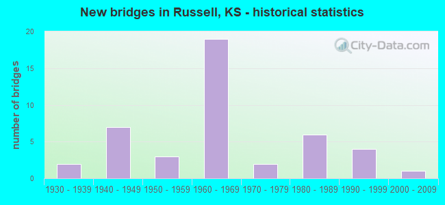
- New bridges - historical statistics
- 21930-1939
- 71940-1949
- 31950-1959
- 191960-1969
- 21970-1979
- 61980-1989
- 41990-1999
- 12000-2009
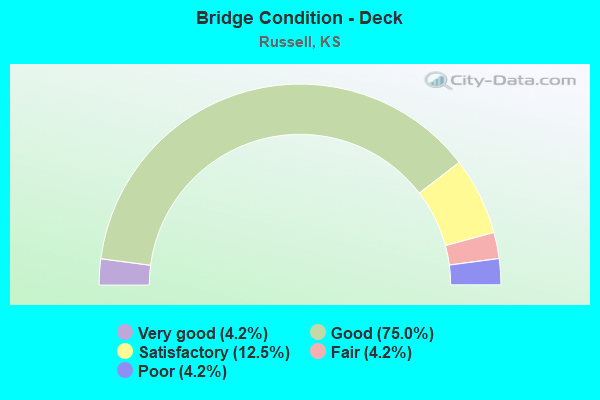
- Bridge Condition - Deck
- 4.2%Very good
- 75.0%Good
- 12.5%Satisfactory
- 4.2%Fair
- 4.2%Poor
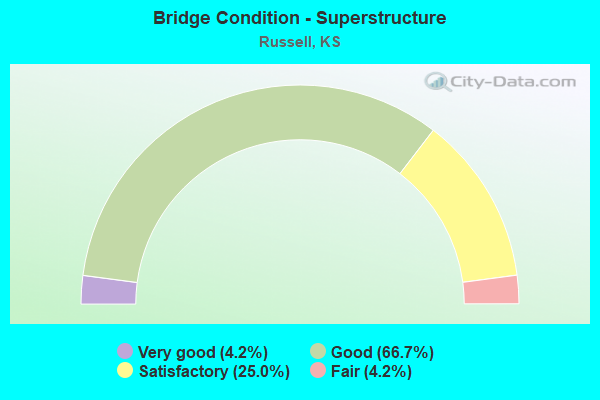
- Bridge Condition - Superstructure
- 4.2%Very good
- 66.7%Good
- 25.0%Satisfactory
- 4.2%Fair
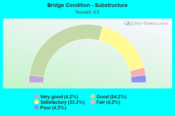
- Bridge Condition - Substructure
- 4.2%Very good
- 54.2%Good
- 33.3%Satisfactory
- 4.2%Fair
- 4.2%Poor
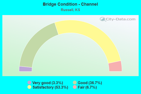
- Bridge Condition - Channel
- 3.3%Very good
- 36.7%Good
- 53.3%Satisfactory
- 6.7%Fair
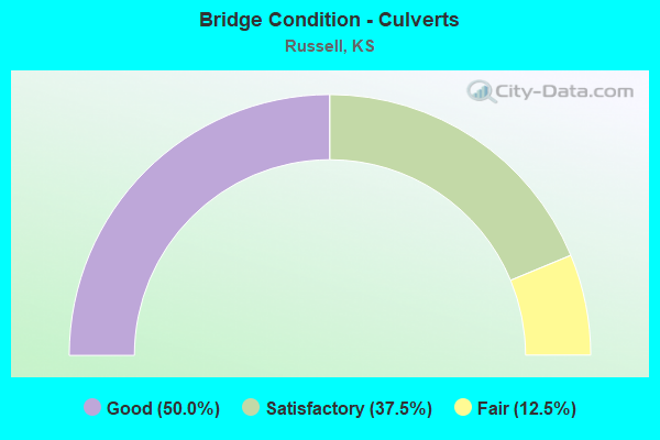
- Bridge Condition - Culverts
- 50.0%Good
- 37.5%Satisfactory
- 12.5%Fair
Find on map >> Show street view
Structure Number: 84014, Location: 3.0W 0.5S OF RUSSELL (Lat: 38.873869, Lng: -98.928342), Route carried "on" structure: County highway 48, Year Built: 1965, Status: Posted for load, Structure Length: 0.63m (2.07ft), Average Daily Traffic: 650 (year 2014), Truck Traffic: 20%, Average Future Daily Traffic: 700 (year 2040), Design Load: H 15, Features Intersected: DRY STREAM
Minimum Vertical Clearance: 30.47m (99.97ft), Kilometerpoint: 0.000, Lanes on structure: 2, Owner: County Highway Agency, Approaching Roadway Width: 7.3m (24.0ft), Material/Design: Concrete, Design/Construction: Culvert, Number Of Spans In Main Unit: 2, Length of Maximum Span: 3.0m (9.8ft), Curb-To-Curb Width: 11.0m (36.1ft), Out-to-Out Width: 11.6m (38.1ft)
Condition: Channel: Satisfactory, Culverts: Satisfactory, Operating Rating: 21.0 metric tons, Method Used To Determine Operating Rating: Load Factor (LF), Inventory Rating: 12.5 metric tons, Method Used To Determine Inventory Rating: Load Factor (LF), Structural Evaluation: High priority of corrective action, Deck Geometry: Better than present minimum criteria, Waterway Adequacy: Equal to present desirable criteria, Approach Roadway Alignment: Equal to present desirable criteria, Bridge Posting: Required (Relationship of Operating Rating to Maximum Legal Load: 30.0 - 39.9% below), Designated Inspection Frequency: Every 24 months, Inspection Date: April 2020, Wearing Surface/Protective System: Wearing Surface: Bituminous
Find on map >> Show street view
Structure Number: 84058, Location: 3.5S 0.8E OF RUSSELL (Lat: 38.812911, Lng: -98.821111), Route carried "on" structure: County highway 1697, Year Built: 1970, Status: Posted for load, Structure Length: 6.10m (20.01ft), Average Daily Traffic: 100 (year 2014), Truck Traffic: 10%, Average Future Daily Traffic: 120 (year 2040), Design Load: H 15, Features Intersected: FOSSIL CREEK
Minimum Vertical Clearance: 30.47m (99.97ft), Kilometerpoint: 0.000, Lanes on structure: 2, Owner: County Highway Agency, Approaching Roadway Width: 8.5m (27.9ft), Skew: 4 degrees, Material/Design: Concrete continuous, Design/Construction: Tee Beam, Number Of Spans In Main Unit: 5, Length of Maximum Span: 13.1m (43.0ft), Curb-To-Curb Width: 8.5m (27.9ft), Out-to-Out Width: 9.1m (29.9ft)
Condition: Deck: Poor, Superstructure: Satisfactory, Substructure: Good, Channel: Good, Operating Rating: 24.3 metric tons, Method Used To Determine Operating Rating: Allowable Stress (AS), Inventory Rating: 18.0 metric tons, Method Used To Determine Inventory Rating: Allowable Stress (AS), Structural Evaluation: Somewhat better than minimum adequacy, Deck Geometry: Better than present minimum criteria, Waterway Adequacy: Better than present minimum criteria, Approach Roadway Alignment: Equal to present desirable criteria, Designated Inspection Frequency: Every 24 months, Inspection Date: April 2020, Deck Structure Type: Concrete Cast-file-Place, Wearing Surface/Protective System: Wearing Surface: Low Slump Concrete
Find on map >> Show street view
Structure Number: 84059, Location: 3.5S 1.75E OF RUSSELL (Lat: 38.812942, Lng: -98.804428), Route carried "on" structure: County highway 1697, Year Built: 1984, Status: Open, Structure Length: 0.96m (3.15ft), Average Daily Traffic: 100 (year 2014), Truck Traffic: 10%, Average Future Daily Traffic: 120 (year 2040), Design Load: H 20, Features Intersected: DRY STREAM
Minimum Vertical Clearance: 30.47m (99.97ft), Kilometerpoint: 0.000, Lanes on structure: 2, Owner: County Highway Agency, Approaching Roadway Width: 7.3m (24.0ft), Material/Design: Concrete, Design/Construction: Culvert, Number Of Spans In Main Unit: 3, Length of Maximum Span: 3.0m (9.8ft), Curb-To-Curb Width: 9.5m (31.2ft), Out-to-Out Width: 10.2m (33.5ft)
Condition: Channel: Satisfactory, Culverts: Fair, Operating Rating: 44.1 metric tons, Method Used To Determine Operating Rating: Allowable Stress (AS), Inventory Rating: 32.4 metric tons, Method Used To Determine Inventory Rating: Allowable Stress (AS), Structural Evaluation: Somewhat better than minimum adequacy, Deck Geometry: Better than present minimum criteria, Waterway Adequacy: Equal to present minimum criteria, Approach Roadway Alignment: Equal to present desirable criteria, Designated Inspection Frequency: Every 24 months, Inspection Date: April 2020, Wearing Surface/Protective System: Wearing Surface: Bituminous
Find on map >> Show street view
Structure Number: 84076, Location: 2.2W 2.7N OF RUSSELL (Lat: 38.946050, Lng: -98.914486), Route carried "on" structure: County highway 2021, Year Built: 1980, Status: Open, Structure Length: 1.51m (4.95ft), Average Daily Traffic: 65 (year 2014), Average Future Daily Traffic: 50 (year 2040), Design Load: HS 20, Features Intersected: DRY STREAM
Minimum Vertical Clearance: 30.47m (99.97ft), Kilometerpoint: 0.000, Lanes on structure: 2, Owner: County Highway Agency, Approaching Roadway Width: 7.6m (24.9ft), Material/Design: Concrete, Design/Construction: Culvert, Number Of Spans In Main Unit: 3, Length of Maximum Span: 4.9m (16.1ft), Curb-To-Curb Width: 9.1m (29.9ft), Out-to-Out Width: 10.1m (33.1ft)
Condition: Channel: Satisfactory, Culverts: Good, Operating Rating: 44.1 metric tons, Method Used To Determine Operating Rating: Allowable Stress (AS), Inventory Rating: 32.4 metric tons, Method Used To Determine Inventory Rating: Allowable Stress (AS), Structural Evaluation: Better than present minimum criteria, Deck Geometry: Better than present minimum criteria, Waterway Adequacy: Better than present minimum criteria, Approach Roadway Alignment: Equal to present desirable criteria, Designated Inspection Frequency: Every 24 months, Inspection Date: April 2020, Wearing Surface/Protective System: Wearing Surface: Gravel
Find on map >> Show street view
Structure Number: 84064930452, Location: 3.25W OF RUSSELL (Lat: 38.899797, Lng: -98.923364), Route carried "on" structure: County highway , Year Built: 1996, Status: Open, Structure Length: 0.73m (2.40ft), Average Daily Traffic: 10 (year 2014), Average Future Daily Traffic: 15 (year 2040), Design Load: HS 20, Features Intersected: STREAM, Facility Carried by Structure: 15TH ST.
Minimum Vertical Clearance: 30.47m (99.97ft), Kilometerpoint: 0.000, Lanes on structure: 2, Owner: County Highway Agency, Approaching Roadway Width: 7.9m (25.9ft), Number Of Spans In Main Unit: 1, Length of Maximum Span: 6.4m (21.0ft), Curb-To-Curb Width: 8.0m (26.2ft), Out-to-Out Width: 8.5m (27.9ft)
Condition: Deck: Good, Superstructure: Good, Substructure: Good, Channel: Satisfactory, Operating Rating: 29.7 metric tons, Method Used To Determine Operating Rating: Allowable Stress (AS), Inventory Rating: 27.9 metric tons, Method Used To Determine Inventory Rating: Allowable Stress (AS), Structural Evaluation: Better than present minimum criteria, Deck Geometry: Equal to present minimum criteria, Waterway Adequacy: Equal to present minimum criteria, Approach Roadway Alignment: Somewhat better than minimum adequacy, Designated Inspection Frequency: Every 24 months, Inspection Date: April 2020, Deck Structure Type: Other, Wearing Surface/Protective System: Wearing Surface: Gravel
Find on map >> Show street view
Structure Number: 840655004567, Location: 1.0W 1.0S OF RUSSELL (Lat: 38.860028, Lng: -98.873042), Route carried "on" structure: County highway , Year Built: 1982, Status: Open, Structure Length: 0.95m (3.12ft), Average Daily Traffic: 200 (year 2014), Average Future Daily Traffic: 200 (year 2040), Design Load: H 20, Features Intersected: FOSSIL CREEK, Facility Carried by Structure: 184TH ST.
Minimum Vertical Clearance: 30.47m (99.97ft), Kilometerpoint: 0.000, Lanes on structure: 2, Owner: County Highway Agency, Approaching Roadway Width: 7.3m (24.0ft), Material/Design: Concrete, Design/Construction: Culvert, Number Of Spans In Main Unit: 3, Length of Maximum Span: 3.0m (9.8ft), Curb-To-Curb Width: 9.1m (29.9ft), Out-to-Out Width: 9.2m (30.2ft)
Condition: Channel: Good, Culverts: Good, Operating Rating: 34.9 metric tons, Method Used To Determine Operating Rating: Load Factor (LF), Inventory Rating: 21.0 metric tons, Method Used To Determine Inventory Rating: Load Factor (LF), Structural Evaluation: Equal to present minimum criteria, Deck Geometry: Equal to present minimum criteria, Waterway Adequacy: Better than present minimum criteria, Approach Roadway Alignment: Equal to present desirable criteria, Designated Inspection Frequency: Every 24 months, Inspection Date: April 2020, Other Special Inspection Date: November 2020, Wearing Surface/Protective System: Wearing Surface: Bituminous
Find on map >> Show street view
Structure Number: 84065560444, Location: 4.0N 0.5W OF RUSSELL (Lat: 38.958411, Lng: -98.862981), Route carried "on" structure: County highway , Year Built: 2001, Status: Open, Structure Length: 8.18m (26.84ft), Average Daily Traffic: 40 (year 2014), Average Future Daily Traffic: 50 (year 2040), Design Load: HS 20, Features Intersected: SALINE RIVER, Facility Carried by Structure: LAND RD.
Minimum Vertical Clearance: 30.47m (99.97ft), Kilometerpoint: 0.000, Lanes on structure: 2, Owner: County Highway Agency, Approaching Roadway Width: 7.3m (24.0ft), Skew: 3 degrees, Material/Design: Concrete continuous, Design/Construction: Slab, Number Of Spans In Main Unit: 5, Length of Maximum Span: 18.0m (59.1ft), Curb-To-Curb Width: 8.6m (28.2ft), Out-to-Out Width: 9.2m (30.2ft)
Condition: Deck: Very good, Superstructure: Very good, Substructure: Very good, Channel: Good, Operating Rating: 72.3 metric tons, Method Used To Determine Operating Rating: Load Factor (LF), Inventory Rating: 43.3 metric tons, Method Used To Determine Inventory Rating: Load Factor (LF), Structural Evaluation: Equal to present desirable criteria, Deck Geometry: Better than present minimum criteria, Waterway Adequacy: Equal to present desirable criteria, Approach Roadway Alignment: Equal to present minimum criteria, Designated Inspection Frequency: Every 24 months, Inspection Date: April 2020, Other Special Inspection Date: November 2020, Deck Structure Type: Concrete Cast-file-Place, Wearing Surface/Protective System: Wearing Surface: Monolithic Concrete
Find on map >> Show street view
Structure Number: 840657504569, Location: 0.5E 2.0S OF RUSSELL (Lat: 38.857622, Lng: -98.845167), Route carried "on" structure: County highway , Year Built: 1994, Status: Posted for load, Structure Length: 0.72m (2.36ft), Average Daily Traffic: 10 (year 2014), Average Future Daily Traffic: 10 (year 2040), Features Intersected: FOSSIL CREEK, Facility Carried by Structure: 186TH BLVD
Minimum Vertical Clearance: 30.47m (99.97ft), Kilometerpoint: 0.000, Lanes on structure: 2, Owner: County Highway Agency, Approaching Roadway Width: 4.8m (15.7ft), Material/Design: Steel, Design/Construction: Stringer/Multi-beam, Number Of Spans In Main Unit: 1, Length of Maximum Span: 6.6m (21.7ft), Curb-To-Curb Width: 6.6m (21.7ft), Out-to-Out Width: 6.8m (22.3ft)
Condition: Deck: Good, Superstructure: Good, Substructure: Satisfactory, Channel: Satisfactory, Operating Rating: 39.0 metric tons, Method Used To Determine Operating Rating: Load Factor (LF), Inventory Rating: 23.3 metric tons, Method Used To Determine Inventory Rating: Load Factor (LF), Structural Evaluation: Equal to present minimum criteria, Deck Geometry: Somewhat better than minimum adequacy, Waterway Adequacy: Equal to present minimum criteria, Approach Roadway Alignment: Equal to present minimum criteria, Bridge Posting: Required (Relationship of Operating Rating to Maximum Legal Load: 10.0 - 19.9% below), Designated Inspection Frequency: Every 24 months, Inspection Date: April 2020, Other Special Inspection Date: November 2020, Deck Structure Type: Open Grating, Wearing Surface/Protective System: Wearing Surface: Other
Find on map >> Show street view
Structure Number: 84065780458, Location: 1.0S 0.7E OF RUSSELL (Lat: 38.856497, Lng: -98.839286), Route carried "on" structure: County highway 8418, Year Built: 1982, Status: Open, Structure Length: 1.50m (4.92ft), Average Daily Traffic: 60 (year 2014), Average Future Daily Traffic: 60 (year 2040), Features Intersected: FOSSIL CREEK, Facility Carried by Structure: I-70 RD.
Minimum Vertical Clearance: 30.47m (99.97ft), Kilometerpoint: 0.000, Lanes on structure: 2, Owner: County Highway Agency, Approaching Roadway Width: 8.5m (27.9ft), Material/Design: Steel continuous, Design/Construction: Stringer/Multi-beam, Number Of Spans In Main Unit: 2, Length of Maximum Span: 7.3m (24.0ft), Curb-To-Curb Width: 8.6m (28.2ft), Out-to-Out Width: 8.7m (28.5ft)
Condition: Deck: Good, Superstructure: Satisfactory, Substructure: Poor, Channel: Satisfactory, Operating Rating: 44.1 metric tons, Method Used To Determine Operating Rating: Allowable Stress (AS), Inventory Rating: 32.4 metric tons, Method Used To Determine Inventory Rating: Allowable Stress (AS), Structural Evaluation: Meets minimum limits, Deck Geometry: Better than present minimum criteria, Waterway Adequacy: Better than present minimum criteria, Approach Roadway Alignment: Equal to present desirable criteria, Designated Inspection Frequency: Every 24 months, Inspection Date: April 2020, Deck Structure Type: Corrugated Steel, Wearing Surface/Protective System: Wearing Surface: Gravel
Find on map >> Show street view
Structure Number: 84065790456, Location: 1.0S 1.0E OF RUSSELL (Lat: 38.870967, Lng: -98.836903), Route carried "on" structure: County highway , Year Built: 1977, Status: Open, Structure Length: 0.76m (2.49ft), Average Daily Traffic: 40 (year 2014), Average Future Daily Traffic: 40 (year 2040), Design Load: H 20, Features Intersected: TRIB. OF FOSSIL CREEK, Facility Carried by Structure: HOMER RD.
Minimum Vertical Clearance: 30.47m (99.97ft), Kilometerpoint: 0.000, Lanes on structure: 2, Owner: County Highway Agency, Approaching Roadway Width: 8.5m (27.9ft), Material/Design: Concrete, Design/Construction: Culvert, Number Of Spans In Main Unit: 2, Length of Maximum Span: 3.7m (12.1ft), Curb-To-Curb Width: 9.1m (29.9ft), Out-to-Out Width: 10.1m (33.1ft)
Condition: Channel: Good, Culverts: Good, Operating Rating: 44.1 metric tons, Method Used To Determine Operating Rating: Allowable Stress (AS), Inventory Rating: 32.4 metric tons, Method Used To Determine Inventory Rating: Allowable Stress (AS), Structural Evaluation: Better than present minimum criteria, Deck Geometry: Better than present minimum criteria, Waterway Adequacy: Better than present minimum criteria, Approach Roadway Alignment: Equal to present desirable criteria, Designated Inspection Frequency: Every 24 months, Inspection Date: April 2020, Wearing Surface/Protective System: Wearing Surface: Gravel
Find on map >> Show street view
Structure Number: 84065930458, Location: 1.0S 1.0E OF RUSSELL (Lat: 38.856667, Lng: -98.829944), Route carried "on" structure: County highway 8418, Year Built: 1985, Status: Open, Structure Length: 1.14m (3.74ft), Average Daily Traffic: 60 (year 2014), Average Future Daily Traffic: 60 (year 2040), Design Load: H 20, Features Intersected: FOSSIL CREEK, Facility Carried by Structure: I-70 RD.
Minimum Vertical Clearance: 30.47m (99.97ft), Kilometerpoint: 0.000, Lanes on structure: 2, Owner: County Highway Agency, Approaching Roadway Width: 8.5m (27.9ft), Material/Design: Concrete, Design/Construction: Culvert, Number Of Spans In Main Unit: 3, Length of Maximum Span: 3.7m (12.1ft), Curb-To-Curb Width: 9.6m (31.5ft), Out-to-Out Width: 10.2m (33.5ft)
Condition: Channel: Fair, Culverts: Good, Operating Rating: 44.1 metric tons, Method Used To Determine Operating Rating: Allowable Stress (AS), Inventory Rating: 32.4 metric tons, Method Used To Determine Inventory Rating: Allowable Stress (AS), Structural Evaluation: Better than present minimum criteria, Deck Geometry: Better than present minimum criteria, Waterway Adequacy: Better than present minimum criteria, Approach Roadway Alignment: Equal to present desirable criteria, Designated Inspection Frequency: Every 24 months, Inspection Date: April 2020, Wearing Surface/Protective System: Wearing Surface: Gravel
Find on map >> Show street view
Structure Number: 84065960462, Location: 4.0S 1.5E OF RUSSELL (Lat: 38.827464, Lng: -98.825664), Route carried "on" structure: County highway , Year Built: 1960, Status: Posted for load, Structure Length: 1.83m (6.00ft), Average Daily Traffic: 60 (year 2014), Average Future Daily Traffic: 70 (year 2040), Features Intersected: FOSSIL CREEK, Facility Carried by Structure: PLYMOUTH RD.
Minimum Vertical Clearance: 30.47m (99.97ft), Kilometerpoint: 0.000, Lanes on structure: 2, Owner: County Highway Agency, Approaching Roadway Width: 7.8m (25.6ft), Material/Design: Steel, Design/Construction: Stringer/Multi-beam, Number Of Spans In Main Unit: 1, Length of Maximum Span: 17.7m (58.1ft), Curb-To-Curb Width: 6.1m (20.0ft), Out-to-Out Width: 6.2m (20.3ft)
Condition: Deck: Good, Superstructure: Satisfactory, Substructure: Good, Channel: Good, Operating Rating: 4.3 metric tons, Method Used To Determine Operating Rating: Load Factor (LF), Inventory Rating: 2.5 metric tons, Method Used To Determine Inventory Rating: Load Factor (LF), Structural Evaluation: High priority of replacement, Deck Geometry: Somewhat better than minimum adequacy, Waterway Adequacy: Equal to present minimum criteria, Approach Roadway Alignment: Equal to present desirable criteria, Bridge Posting: Required (Relationship of Operating Rating to Maximum Legal Load: > 39.9% below), Length Of Structure Improvement: 2.13m (6.99ft), Designated Inspection Frequency: Every 24 months, Inspection Date: April 2020, Bridge Improvement Cost: $120,000, Roadway Improvement Cost: $15,000, Total Project Cost: $150,000, Deck Structure Type: Concrete Cast-file-Place, Wearing Surface/Protective System: Wearing Surface: Gravel
Find on map >> Show street view
Structure Number: 840661004641, Location: 5.0S 2.0E OF RUSSELL (Lat: 38.810833, Lng: -98.817778), Route carried "on" structure: County highway , Year Built: 1950, Status: Posted for load, Structure Length: 0.70m (2.30ft), Average Daily Traffic: 25 (year 2014), Average Future Daily Traffic: 30 (year 2040), Features Intersected: FOSSIL CREEK, Facility Carried by Structure: 187TH RD.
Minimum Vertical Clearance: 30.47m (99.97ft), Kilometerpoint: 0.000, Lanes on structure: 2, Owner: County Highway Agency, Approaching Roadway Width: 7.3m (24.0ft), Material/Design: Steel, Design/Construction: Culvert, Number Of Spans In Main Unit: 1, Length of Maximum Span: 7.0m (23.0ft), Curb-To-Curb Width: 7.2m (23.6ft), Out-to-Out Width: 7.6m (24.9ft)
Condition: Channel: Satisfactory, Culverts: Satisfactory, Operating Rating: 26.1 metric tons, Method Used To Determine Operating Rating: Allowable Stress (AS), Inventory Rating: 18.9 metric tons, Method Used To Determine Inventory Rating: Allowable Stress (AS), Structural Evaluation: Somewhat better than minimum adequacy, Deck Geometry: Somewhat better than minimum adequacy, Waterway Adequacy: Equal to present minimum criteria, Approach Roadway Alignment: Equal to present minimum criteria, Designated Inspection Frequency: Every 24 months, Inspection Date: April 2020, Wearing Surface/Protective System: Wearing Surface: Gravel
Find on map >> Show street view
Structure Number: 84066140462, Location: 4.0S 3.0E OF RUSSELL (Lat: 38.827514, Lng: -98.805942), Route carried "on" structure: County highway , Year Built: 1984, Status: Open, Structure Length: 0.75m (2.46ft), Average Daily Traffic: 60 (year 2014), Average Future Daily Traffic: 60 (year 2040), Design Load: H 20, Features Intersected: DRY STREAM, Facility Carried by Structure: PLYMOUTH RD.
Minimum Vertical Clearance: 30.47m (99.97ft), Kilometerpoint: 0.000, Lanes on structure: 2, Owner: County Highway Agency, Approaching Roadway Width: 9.1m (29.9ft), Material/Design: Concrete, Design/Construction: Culvert, Number Of Spans In Main Unit: 3, Length of Maximum Span: 2.4m (7.9ft), Curb-To-Curb Width: 9.8m (32.2ft), Out-to-Out Width: 10.2m (33.5ft)
Condition: Channel: Good, Culverts: Good, Operating Rating: 44.1 metric tons, Method Used To Determine Operating Rating: Allowable Stress (AS), Inventory Rating: 32.4 metric tons, Method Used To Determine Inventory Rating: Allowable Stress (AS), Structural Evaluation: Better than present minimum criteria, Deck Geometry: Equal to present desirable criteria, Waterway Adequacy: Better than present minimum criteria, Approach Roadway Alignment: Equal to present desirable criteria, Designated Inspection Frequency: Every 24 months, Inspection Date: April 2020, Wearing Surface/Protective System: Wearing Surface: Gravel
Find on map >> Show street view
Structure Number: 425000844704C01, Location: EAST OF FOSSIL IN RUSSELL (Lat: 38.893100, Lng: -98.855039), Route carried "on" structure: City street 4704, Year Built: 1950, Status: Open, Structure Length: 1.40m (4.59ft), Average Daily Traffic: 2,025 (year 2017), Truck Traffic: 5%, Average Future Daily Traffic: 2,250 (year 2041), Design Load: H 20, Features Intersected: FOSSIL CREEK, Facility Carried by Structure: STATE STREET
Minimum Vertical Clearance: 30.47m (99.97ft), Kilometerpoint: 0.000, Lanes on structure: 2, Owner: City or Municipal Highway Agency, Approaching Roadway Width: 12.1m (39.7ft), Material/Design: Concrete continuous, Design/Construction: Slab, Number Of Spans In Main Unit: 5, Length of Maximum Span: 2.6m (8.5ft), Curb or Sidewalk Widths: Left: 1.5m (4.9ft), Right: 1.5m (4.9ft), Curb-To-Curb Width: 12.1m (39.7ft), Out-to-Out Width: 15.1m (49.5ft)
Condition: Deck: Satisfactory, Superstructure: Satisfactory, Substructure: Satisfactory, Channel: Satisfactory, Operating Rating: 24.3 metric tons, Method Used To Determine Operating Rating: Load Factor (LF), Inventory Rating: 14.5 metric tons, Method Used To Determine Inventory Rating: Load Factor (LF), Structural Evaluation: Meets minimum limits, Deck Geometry: Somewhat better than minimum adequacy, Waterway Adequacy: Better than present minimum criteria, Approach Roadway Alignment: Equal to present desirable criteria, Designated Inspection Frequency: Every 24 months, Inspection Date: Febuary 2021, Deck Structure Type: Concrete Cast-file-Place, Wearing Surface/Protective System: Wearing Surface: Bituminous, Deck Protection: Bituminous
Find on map >> Show street view
Structure Number: 525000840000C02, Location: EAST OF FOSSIL IN RUSSELL (Lat: 38.892158, Lng: -98.855047), Route carried "on" structure: City street , Year Built: 1942, Year Reconstructed: 1950, Status: Open, Structure Length: 1.31m (4.30ft), Average Daily Traffic: 500 (year 2017), Truck Traffic: 5%, Average Future Daily Traffic: 550 (year 2041), Design Load: H 20, Features Intersected: FOSSIL CREEK, Facility Carried by Structure: 7TH. STREET
Minimum Vertical Clearance: 30.47m (99.97ft), Kilometerpoint: 0.000, Lanes on structure: 2, Owner: City or Municipal Highway Agency, Approaching Roadway Width: 8.9m (29.2ft), Material/Design: Concrete, Design/Construction: Culvert, Number Of Spans In Main Unit: 2, Number Of Approach Spans: 2, Length of Maximum Span: 2.9m (9.5ft), Curb-To-Curb Width: 9.0m (29.5ft), Out-to-Out Width: 11.0m (36.1ft)
Condition: Channel: Satisfactory, Culverts: Fair, Operating Rating: 32.7 metric tons, Method Used To Determine Operating Rating: Field evaluation and documented engineering judgment, Inventory Rating: 32.7 metric tons, Method Used To Determine Inventory Rating: Field evaluation and documented engineering judgment, Structural Evaluation: Somewhat better than minimum adequacy, Deck Geometry: Somewhat better than minimum adequacy, Waterway Adequacy: Equal to present minimum criteria, Approach Roadway Alignment: Equal to present desirable criteria, Designated Inspection Frequency: Every 24 months, Inspection Date: Febuary 2021, Other Special Inspection Date: November 2020, Wearing Surface/Protective System: Wearing Surface: Other
Find on map >> Show street view
Structure Number: 525000840000C03, Location: AT INTERSECTION-RUSSELL (Lat: 38.891181, Lng: -98.854406), Route carried "on" structure: City street , Year Built: 1946, Status: Open, Structure Length: 1.39m (4.56ft), Average Daily Traffic: 500 (year 2017), Truck Traffic: 5%, Average Future Daily Traffic: 550 (year 2041), Design Load: H 20, Features Intersected: FOSSIL CREEK, Facility Carried by Structure: WISCONSIN & FRONT
Minimum Vertical Clearance: 30.47m (99.97ft), Kilometerpoint: 0.000, Lanes on structure: 2, Owner: City or Municipal Highway Agency, Approaching Roadway Width: 7.0m (23.0ft), Material/Design: Concrete continuous, Design/Construction: Slab, Number Of Spans In Main Unit: 5, Length of Maximum Span: 2.7m (8.9ft), Curb or Sidewalk Widths: Left: 0.9m (3.0ft), Right: 0.9m (3.0ft), Curb-To-Curb Width: 7.0m (23.0ft), Out-to-Out Width: 21.9m (71.9ft)
Condition: Deck: Fair, Superstructure: Fair, Substructure: Satisfactory, Channel: Satisfactory, Operating Rating: 32.7 metric tons, Method Used To Determine Operating Rating: Field evaluation and documented engineering judgment, Inventory Rating: 32.7 metric tons, Method Used To Determine Inventory Rating: Field evaluation and documented engineering judgment, Structural Evaluation: Somewhat better than minimum adequacy, Deck Geometry: Meets minimum limits, Waterway Adequacy: Better than present minimum criteria, Approach Roadway Alignment: Better than present minimum criteria, Designated Inspection Frequency: Every 24 months, Inspection Date: Febuary 2021, Other Special Inspection Date: November 2020, Deck Structure Type: Concrete Cast-file-Place, Wearing Surface/Protective System: Wearing Surface: Monolithic Concrete
Find on map >> Show street view
Structure Number: 525000840000C04, Location: AT INT-5TH &SEITZ-RUSSELL (Lat: 38.890208, Lng: -98.852633), Route carried "on" structure: City street , Year Built: 1948, Status: Open, Structure Length: 1.69m (5.54ft), Average Daily Traffic: 500 (year 2017), Truck Traffic: 5%, Average Future Daily Traffic: 550 (year 2041), Design Load: H 20, Features Intersected: FOSSIL CREEK, Facility Carried by Structure: 5TH. ST. & SEITZ
Minimum Vertical Clearance: 30.47m (99.97ft), Kilometerpoint: 0.000, Lanes on structure: 2, Owner: City or Municipal Highway Agency, Approaching Roadway Width: 9.1m (29.9ft), Material/Design: Concrete continuous, Design/Construction: Slab, Number Of Spans In Main Unit: 6, Length of Maximum Span: 2.7m (8.9ft), Curb or Sidewalk Widths: Left: 1.4m (4.6ft), Right: 1.4m (4.6ft), Curb-To-Curb Width: 9.1m (29.9ft), Out-to-Out Width: 23.6m (77.4ft)
Condition: Deck: Satisfactory, Superstructure: Satisfactory, Substructure: Satisfactory, Channel: Satisfactory, Operating Rating: 32.7 metric tons, Method Used To Determine Operating Rating: Field evaluation and documented engineering judgment, Inventory Rating: 32.7 metric tons, Method Used To Determine Inventory Rating: Field evaluation and documented engineering judgment, Structural Evaluation: Equal to present minimum criteria, Deck Geometry: Equal to present minimum criteria, Waterway Adequacy: Equal to present minimum criteria, Approach Roadway Alignment: Better than present minimum criteria, Designated Inspection Frequency: Every 24 months, Inspection Date: Febuary 2021, Other Special Inspection Date: November 2020, Deck Structure Type: Other, Wearing Surface/Protective System: Wearing Surface: Monolithic Concrete, Deck Protection: Bituminous
Find on map >> Show street view
Structure Number: 525000840000C05, Location: WEST OF FRANKLIN-RUSSELL (Lat: 38.889231, Lng: -98.851833), Route carried "on" structure: City street , Year Built: 1950, Status: Open, Structure Length: 1.93m (6.33ft), Average Daily Traffic: 500 (year 2017), Truck Traffic: 5%, Average Future Daily Traffic: 550 (year 2040), Features Intersected: FOSSIL CREEK, Facility Carried by Structure: 4TH. STREET
Minimum Vertical Clearance: 30.47m (99.97ft), Kilometerpoint: 0.000, Lanes on structure: 2, Owner: City or Municipal Highway Agency, Approaching Roadway Width: 9.0m (29.5ft), Skew: 3 degrees, Material/Design: Concrete continuous, Design/Construction: Slab, Number Of Spans In Main Unit: 6, Length of Maximum Span: 3.0m (9.8ft), Curb or Sidewalk Widths: Left: 1.5m (4.9ft), Right: 1.5m (4.9ft), Curb-To-Curb Width: 9.1m (29.9ft), Out-to-Out Width: 12.0m (39.4ft)
Condition: Deck: Good, Superstructure: Good, Substructure: Satisfactory, Channel: Satisfactory, Operating Rating: 28.8 metric tons, Method Used To Determine Operating Rating: Load Factor (LF), Inventory Rating: 17.2 metric tons, Method Used To Determine Inventory Rating: Load Factor (LF), Structural Evaluation: Somewhat better than minimum adequacy, Deck Geometry: Equal to present minimum criteria, Waterway Adequacy: Better than present minimum criteria, Approach Roadway Alignment: Equal to present desirable criteria, Designated Inspection Frequency: Every 24 months, Inspection Date: Febuary 2021, Other Special Inspection Date: November 2020, Deck Structure Type: Concrete Cast-file-Place, Wearing Surface/Protective System: Wearing Surface: Monolithic Concrete
Find on map >> Show street view
Structure Number: 525000840000C06, Location: WEST OF FRANKLIN-RUSSELL (Lat: 38.888300, Lng: -98.851081), Route carried "on" structure: City street , Year Built: 1949, Status: Posted for load, Structure Length: 1.67m (5.48ft), Average Daily Traffic: 500 (year 2017), Truck Traffic: 5%, Average Future Daily Traffic: 550 (year 2041), Features Intersected: FOSSIL CREEK, Facility Carried by Structure: 3RD. STREET
Minimum Vertical Clearance: 30.47m (99.97ft), Kilometerpoint: 0.000, Lanes on structure: 2, Owner: City or Municipal Highway Agency, Approaching Roadway Width: 9.0m (29.5ft), Material/Design: Concrete continuous, Design/Construction: Slab, Number Of Spans In Main Unit: 6, Length of Maximum Span: 2.6m (8.5ft), Curb or Sidewalk Widths: Left: 1.5m (4.9ft), Right: 1.5m (4.9ft), Curb-To-Curb Width: 9.1m (29.9ft), Out-to-Out Width: 12.0m (39.4ft)
Condition: Deck: Good, Superstructure: Good, Substructure: Satisfactory, Channel: Satisfactory, Operating Rating: 24.2 metric tons, Method Used To Determine Operating Rating: Load Factor (LF), Inventory Rating: 14.4 metric tons, Method Used To Determine Inventory Rating: Load Factor (LF), Structural Evaluation: Meets minimum limits, Deck Geometry: Equal to present minimum criteria, Waterway Adequacy: Better than present minimum criteria, Approach Roadway Alignment: Equal to present desirable criteria, Bridge Posting: Required (Relationship of Operating Rating to Maximum Legal Load: 30.0 - 39.9% below), Designated Inspection Frequency: Every 24 months, Inspection Date: Febuary 2021, Other Special Inspection Date: November 2020, Deck Structure Type: Concrete Cast-file-Place, Wearing Surface/Protective System: Wearing Surface: Monolithic Concrete
Find on map >> Show street view
Structure Number: 525000840000C07, Location: EAST OF FRANKLIN-RUSSELL (Lat: 38.887372, Lng: -98.850394), Route carried "on" structure: City street , Year Built: 1949, Status: Posted for load, Structure Length: 2.37m (7.78ft), Average Daily Traffic: 500 (year 2017), Truck Traffic: 5%, Average Future Daily Traffic: 550 (year 2041), Features Intersected: FOSSIL CREEK, Facility Carried by Structure: 2ND. STREET
Minimum Vertical Clearance: 30.47m (99.97ft), Kilometerpoint: 0.000, Lanes on structure: 2, Owner: City or Municipal Highway Agency, Approaching Roadway Width: 9.0m (29.5ft), Skew: 4 degrees, Material/Design: Concrete continuous, Design/Construction: Slab, Number Of Spans In Main Unit: 6, Length of Maximum Span: 3.7m (12.1ft), Curb or Sidewalk Widths: Left: 1.5m (4.9ft), Right: 1.5m (4.9ft), Curb-To-Curb Width: 9.1m (29.9ft), Out-to-Out Width: 12.0m (39.4ft)
Condition: Deck: Good, Superstructure: Good, Substructure: Fair, Channel: Fair, Operating Rating: 24.2 metric tons, Method Used To Determine Operating Rating: Load Factor (LF), Inventory Rating: 14.4 metric tons, Method Used To Determine Inventory Rating: Load Factor (LF), Structural Evaluation: Meets minimum limits, Deck Geometry: Equal to present minimum criteria, Waterway Adequacy: Better than present minimum criteria, Approach Roadway Alignment: Equal to present desirable criteria, Bridge Posting: Required (Relationship of Operating Rating to Maximum Legal Load: 30.0 - 39.9% below), Designated Inspection Frequency: Every 24 months, Inspection Date: Febuary 2021, Other Special Inspection Date: November 2020, Deck Structure Type: Concrete Cast-file-Place, Wearing Surface/Protective System: Wearing Surface: Monolithic Concrete
Find on map >> Show street view
Structure Number: 525000840000C09, Location: SOUTH OF 12TH STREET (Lat: 38.896844, Lng: -98.859783), Route carried "on" structure: City street , Year Built: 1998, Status: Open, Structure Length: 0.80m (2.62ft), Average Daily Traffic: 500 (year 2017), Truck Traffic: 10%, Average Future Daily Traffic: 550 (year 2041), Design Load: HS 20, Features Intersected: FOSSIL CREEK, Facility Carried by Structure: MAIN STREET
Minimum Vertical Clearance: 30.47m (99.97ft), Kilometerpoint: 0.000, Lanes on structure: 2, Owner: City or Municipal Highway Agency, Approaching Roadway Width: 12.1m (39.7ft), Material/Design: Concrete, Design/Construction: Culvert, Number Of Spans In Main Unit: 3, Length of Maximum Span: 2.4m (7.9ft), Curb or Sidewalk Widths: Left: 3.5m (11.5ft), Right: 3.5m (11.5ft), Curb-To-Curb Width: 12.1m (39.7ft), Out-to-Out Width: 19.5m (64.0ft)
Condition: Channel: Good, Culverts: Good, Operating Rating: 32.7 metric tons, Method Used To Determine Operating Rating: Field evaluation and documented engineering judgment, Inventory Rating: 32.7 metric tons, Method Used To Determine Inventory Rating: Field evaluation and documented engineering judgment, Structural Evaluation: Better than present minimum criteria, Deck Geometry: Better than present minimum criteria, Waterway Adequacy: Somewhat better than minimum adequacy, Approach Roadway Alignment: Equal to present desirable criteria, Designated Inspection Frequency: Every 24 months, Inspection Date: Febuary 2021, Other Special Inspection Date: November 2020, Wearing Surface/Protective System: Wearing Surface: Other
Find on map >> Show street view
Structure Number: 525000840000C1, Location: EAST OF KANSAS STREET (Lat: 38.895958, Lng: -98.858450), Route carried "on" structure: City street , Year Built: 1946, Status: Open, Structure Length: 1.26m (4.13ft), Average Daily Traffic: 500 (year 2017), Truck Traffic: 5%, Average Future Daily Traffic: 550 (year 2041), Design Load: H 20, Features Intersected: FOSSIL CREEK, Facility Carried by Structure: 11TH. STREET
Minimum Vertical Clearance: 30.47m (99.97ft), Kilometerpoint: 0.000, Lanes on structure: 2, Owner: City or Municipal Highway Agency, Approaching Roadway Width: 8.9m (29.2ft), Skew: 3 degrees, Material/Design: Concrete, Design/Construction: Culvert, Number Of Spans In Main Unit: 4, Length of Maximum Span: 3.0m (9.8ft), Curb or Sidewalk Widths: Left: 1.5m (4.9ft), Right: 1.5m (4.9ft), Curb-To-Curb Width: 9.0m (29.5ft), Out-to-Out Width: 11.9m (39.0ft)
Condition: Channel: Satisfactory, Culverts: Satisfactory, Operating Rating: 32.7 metric tons, Method Used To Determine Operating Rating: Field evaluation and documented engineering judgment, Inventory Rating: 32.7 metric tons, Method Used To Determine Inventory Rating: Field evaluation and documented engineering judgment, Structural Evaluation: Equal to present minimum criteria, Deck Geometry: Somewhat better than minimum adequacy, Waterway Adequacy: Equal to present minimum criteria, Approach Roadway Alignment: Equal to present desirable criteria, Designated Inspection Frequency: Every 24 months, Inspection Date: Febuary 2021, Other Special Inspection Date: November 2020, Wearing Surface/Protective System: Wearing Surface: Monolithic Concrete
Find on map >> Show street view
Structure Number: 525000840000C11, Location: SOUTH OF 12TH. STREET (Lat: 38.896839, Lng: -98.858667), Route carried "on" structure: City street , Year Built: 1998, Status: Open, Structure Length: 0.84m (2.76ft), Average Daily Traffic: 500 (year 2017), Truck Traffic: 5%, Average Future Daily Traffic: 550 (year 2041), Design Load: HS 20, Features Intersected: FOSSIL CREEK, Facility Carried by Structure: KANSAS STREET
Minimum Vertical Clearance: 30.47m (99.97ft), Kilometerpoint: 0.000, Lanes on structure: 2, Owner: City or Municipal Highway Agency, Approaching Roadway Width: 9.1m (29.9ft), Skew: 1 degrees, Material/Design: Concrete, Design/Construction: Culvert, Number Of Spans In Main Unit: 3, Length of Maximum Span: 2.5m (8.2ft), Curb or Sidewalk Widths: Left: 4.7m (15.4ft), Right: 3.4m (11.2ft), Curb-To-Curb Width: 9.1m (29.9ft), Out-to-Out Width: 17.6m (57.7ft)
Condition: Channel: Good, Culverts: Good, Operating Rating: 32.7 metric tons, Method Used To Determine Operating Rating: Field evaluation and documented engineering judgment, Inventory Rating: 32.7 metric tons, Method Used To Determine Inventory Rating: Field evaluation and documented engineering judgment, Structural Evaluation: Better than present minimum criteria, Deck Geometry: Equal to present minimum criteria, Waterway Adequacy: Somewhat better than minimum adequacy, Approach Roadway Alignment: Equal to present desirable criteria, Designated Inspection Frequency: Every 24 months, Inspection Date: Febuary 2021, Other Special Inspection Date: November 2020, Wearing Surface/Protective System: Wearing Surface: Monolithic Concrete
Find on map >> Show street view
Structure Number: 525000840000C12, Location: BETWEEN MAIN & MAPLE (Lat: 38.896925, Lng: -98.860381), Route carried "on" structure: City street , Year Built: 1946, Status: Open, Structure Length: 0.97m (3.18ft), Average Daily Traffic: 500 (year 2017), Truck Traffic: 10%, Average Future Daily Traffic: 550 (year 2041), Design Load: H 20, Features Intersected: FOSSIL CREEK, Facility Carried by Structure: 12TH. STREET
Minimum Vertical Clearance: 30.47m (99.97ft), Kilometerpoint: 0.000, Lanes on structure: 2, Owner: City or Municipal Highway Agency, Approaching Roadway Width: 9.0m (29.5ft), Skew: 4 degrees, Material/Design: Concrete continuous, Design/Construction: Slab, Number Of Spans In Main Unit: 2, Length of Maximum Span: 4.7m (15.4ft), Curb or Sidewalk Widths: Left: 0.3m (1.0ft), Right: 0.3m (1.0ft), Curb-To-Curb Width: 9.1m (29.9ft), Out-to-Out Width: 9.7m (31.8ft)
Condition: Deck: Satisfactory, Superstructure: Satisfactory, Substructure: Satisfactory, Channel: Satisfactory, Operating Rating: 32.7 metric tons, Method Used To Determine Operating Rating: Field evaluation and documented engineering judgment, Inventory Rating: 32.7 metric tons, Method Used To Determine Inventory Rating: Field evaluation and documented engineering judgment, Structural Evaluation: Equal to present minimum criteria, Deck Geometry: Equal to present minimum criteria, Waterway Adequacy: Equal to present minimum criteria, Approach Roadway Alignment: Equal to present desirable criteria, Designated Inspection Frequency: Every 24 months, Inspection Date: Febuary 2021, Other Special Inspection Date: November 2020, Deck Structure Type: Concrete Cast-file-Place, Wearing Surface/Protective System: Wearing Surface: Monolithic Concrete
Find on map >> Show street view
Structure Number: 9999040B0840354, Location: 0.46 MI E JT U281 (Lat: 38.885561, Lng: -98.847631), Route carried "on" structure: City street 1910, Year Built: 1930, Status: Open, Structure Length: 0.78m (2.56ft), Average Daily Traffic: 3,180 (year 2017), Truck Traffic: 5%, Average Future Daily Traffic: 6,500 (year 2041), Design Load: H 15, Features Intersected: FOSSIL CREEK, Facility Carried by Structure: E. WICHITA AVE.
Minimum Vertical Clearance: 30.47m (99.97ft), Kilometerpoint: 0.000, Lanes on structure: 2, Owner: City or Municipal Highway Agency, Approaching Roadway Width: 7.3m (24.0ft), Material/Design: Concrete, Design/Construction: Culvert, Number Of Spans In Main Unit: 3, Length of Maximum Span: 2.4m (7.9ft), Curb-To-Curb Width: 9.8m (32.2ft), Out-to-Out Width: 9.9m (32.5ft)
Condition: Channel: Good, Culverts: Satisfactory, Operating Rating: 35.2 metric tons, Method Used To Determine Operating Rating: Load Factor (LF), Inventory Rating: 20.2 metric tons, Method Used To Determine Inventory Rating: Load Factor (LF), Structural Evaluation: Somewhat better than minimum adequacy, Deck Geometry: Meets minimum limits, Waterway Adequacy: High priority of corrective action, Approach Roadway Alignment: Equal to present desirable criteria, Designated Inspection Frequency: Every 24 months, Inspection Date: Febuary 2021, Deck Structure Type: Concrete Cast-file-Place, Wearing Surface/Protective System: Wearing Surface: Bituminous
Find on map >> Show street view
Structure Number: 999907000840071, Location: 6.04 MI E ELLIS CO LN (Lat: 38.863889, Lng: -98.928333), Route carried "on" structure: County highway 48, Year Built: 1965, Status: Open, Structure Length: 7.33m (24.05ft), Average Daily Traffic: 585 (year 2020), Average Future Daily Traffic: 9,176 (year 2041), Design Load: H 20, Features Intersected: I70 HWY, NL-SL
Minimum Vertical Clearance: 30.47m (99.97ft), Kilometerpoint: 21.826, Lanes on structure: 2, Lanes under structure: 4, Owner: State Highway Agency, Approaching Roadway Width: 9.1m (29.9ft), Material/Design: Concrete continuous, Design/Construction: Box Beam or Girders - Multiple, Number Of Spans In Main Unit: 4, Length of Maximum Span: 20.7m (67.9ft), Curb-To-Curb Width: 8.5m (27.9ft), Out-to-Out Width: 8.9m (29.2ft)
Condition: Deck: Good, Superstructure: Good, Substructure: Satisfactory, Operating Rating: 72.1 metric tons, Method Used To Determine Operating Rating: Load Factor (LF), Inventory Rating: 43.2 metric tons, Method Used To Determine Inventory Rating: Load Factor (LF), Structural Evaluation: Equal to present minimum criteria, Deck Geometry: Somewhat better than minimum adequacy, Underclear: Somewhat better than minimum adequacy, Approach Roadway Alignment: Meets minimum limits, Length Of Structure Improvement: 24.05m (78.90ft), Designated Inspection Frequency: Every 24 months, Inspection Date: April 2021, Deck Structure Type: Concrete Cast-file-Place, Wearing Surface/Protective System: Wearing Surface: Low Slump Concrete
Find on map >> Show street view
Structure Number: 999907000840081, Location: 7.92 MI E ELLIS CO LN (Lat: 38.863889, Lng: -98.893333), Route carried "on" structure: Interstate 70, Year Built: 1965, Status: Open, Structure Length: 1.14m (3.74ft), Average Daily Traffic: 7,147 (year 2020), Truck Traffic: 26%, Average Future Daily Traffic: 10,013 (year 2041), Design Load: HS 20+Mod, Features Intersected: FOSSIL CREEK
Minimum Vertical Clearance: 30.47m (99.97ft), Kilometerpoint: 12.682, Lanes on structure: 4, Base Highway Network: Yes, Owner: State Highway Agency, Approaching Roadway Width: 24.4m (80.1ft), Skew: 20 degrees, Material/Design: Concrete, Design/Construction: Culvert, Number Of Spans In Main Unit: 3, Length of Maximum Span: 3.7m (12.1ft), Curb-To-Curb Width: 24.4m (80.1ft), Out-to-Out Width: 45.6m (149.6ft)
Condition: Channel: Good, Culverts: Satisfactory, Operating Rating: 52.2 metric tons, Method Used To Determine Operating Rating: Load Factor (LF), Inventory Rating: 31.2 metric tons, Method Used To Determine Inventory Rating: Load Factor (LF), Structural Evaluation: Equal to present minimum criteria, Deck Geometry: Superior to present desirable criteria, Waterway Adequacy: Equal to present minimum criteria, Approach Roadway Alignment: Equal to present desirable criteria, Length Of Structure Improvement: 3.75m (12.30ft), Designated Inspection Frequency: Every 24 months, Inspection Date: April 2021, Deck Structure Type: Concrete Cast-file-Place, Wearing Surface/Protective System: Wearing Surface: Bituminous
Find on map >> Show street view
Structure Number: 999907000840091, Location: 9.03 MI E ELLIS CO LN (Lat: 38.863889, Lng: -98.872778), Route carried "on" structure: ServiceCounty highway 28, Year Built: 1965, Status: Open, Structure Length: 7.33m (24.05ft), Average Daily Traffic: 22 (year 2020), Average Future Daily Traffic: 9,176 (year 2041), Design Load: H 20, Features Intersected: I70 HWY, NL-SL, Facility Carried by Structure: LOCAL ROAD
Minimum Vertical Clearance: 30.47m (99.97ft), Kilometerpoint: 0.782, Lanes on structure: 2, Lanes under structure: 4, Owner: State Highway Agency, Approaching Roadway Width: 7.3m (24.0ft), Material/Design: Concrete continuous, Design/Construction: Box Beam or Girders - Multiple, Number Of Spans In Main Unit: 4, Length of Maximum Span: 20.7m (67.9ft), Curb-To-Curb Width: 8.5m (27.9ft), Out-to-Out Width: 8.9m (29.2ft)
Condition: Deck: Good, Superstructure: Good, Substructure: Good, Operating Rating: 72.1 metric tons, Method Used To Determine Operating Rating: Load Factor (LF), Inventory Rating: 43.2 metric tons, Method Used To Determine Inventory Rating: Load Factor (LF), Structural Evaluation: Better than present minimum criteria, Deck Geometry: Better than present minimum criteria, Underclear: Somewhat better than minimum adequacy, Approach Roadway Alignment: Somewhat better than minimum adequacy, Length Of Structure Improvement: 24.05m (78.90ft), Designated Inspection Frequency: Every 24 months, Inspection Date: April 2021, Deck Structure Type: Concrete Cast-file-Place, Wearing Surface/Protective System: Wearing Surface: Monolithic Concrete
Find on map >> Show street view
Structure Number: 999907000840101, Location: JT U281/I70, WB (Lat: 38.864167, Lng: -98.854444), Route carried "on" structure: Interstate 70, Year Built: 1965, Status: Open, Structure Length: 5.20m (17.06ft), Average Daily Traffic: 6,547 (year 2020), Truck Traffic: 28%, Average Future Daily Traffic: 9,172 (year 2041), Design Load: HS 20+Mod, Features Intersected: US281 HWY
Minimum Vertical Clearance: 30.47m (99.97ft), Kilometerpoint: 16.071, Lanes on structure: 2, Lanes under structure: 4, Base Highway Network: Yes, Owner: State Highway Agency, Approaching Roadway Width: 12.2m (40.0ft), Material/Design: Concrete continuous, Design/Construction: Slab, Number Of Spans In Main Unit: 4, Length of Maximum Span: 14.6m (47.9ft), Curb-To-Curb Width: 12.2m (40.0ft), Out-to-Out Width: 12.8m (42.0ft)
Condition: Deck: Good, Superstructure: Good, Substructure: Good, Operating Rating: 59.9 metric tons, Method Used To Determine Operating Rating: Load Factor (LF), Inventory Rating: 35.4 metric tons, Method Used To Determine Inventory Rating: Load Factor (LF), Structural Evaluation: Better than present minimum criteria, Deck Geometry: Better than present minimum criteria, Underclear: Meets minimum limits, Approach Roadway Alignment: Equal to present desirable criteria, Length Of Structure Improvement: 17.05m (55.94ft), Designated Inspection Frequency: Every 24 months, Inspection Date: April 2021, Deck Structure Type: Concrete Cast-file-Place, Wearing Surface/Protective System: Wearing Surface: Low Slump Concrete
Find on map >> Show street view
Structure Number: 999907000840111, Location: JT U281/I70, EB (Lat: 38.863889, Lng: -98.854444), Route carried "on" structure: Interstate 70, Year Built: 1965, Status: Open, Structure Length: 5.20m (17.06ft), Average Daily Traffic: 6,547 (year 2020), Truck Traffic: 28%, Average Future Daily Traffic: 9,172 (year 2041), Design Load: HS 20+Mod, Features Intersected: US281 HWY
Minimum Vertical Clearance: 30.47m (99.97ft), Kilometerpoint: 16.077, Lanes on structure: 2, Lanes under structure: 4, Base Highway Network: Yes, Owner: State Highway Agency, Approaching Roadway Width: 12.2m (40.0ft), Material/Design: Concrete continuous, Design/Construction: Slab, Number Of Spans In Main Unit: 4, Length of Maximum Span: 14.6m (47.9ft), Curb-To-Curb Width: 12.2m (40.0ft), Out-to-Out Width: 12.8m (42.0ft)
Condition: Deck: Good, Superstructure: Good, Substructure: Good, Operating Rating: 59.9 metric tons, Method Used To Determine Operating Rating: Load Factor (LF), Inventory Rating: 35.4 metric tons, Method Used To Determine Inventory Rating: Load Factor (LF), Structural Evaluation: Better than present minimum criteria, Deck Geometry: Better than present minimum criteria, Underclear: Meets minimum limits, Approach Roadway Alignment: Equal to present desirable criteria, Length Of Structure Improvement: 17.05m (55.94ft), Designated Inspection Frequency: Every 24 months, Inspection Date: April 2021, Deck Structure Type: Concrete Cast-file-Place, Wearing Surface/Protective System: Wearing Surface: Low Slump Concrete
Find on map >> Show street view
Structure Number: 999907000840121, Location: 0.95MI E JT U281 (Lat: 38.863333, Lng: -98.836667), Route carried "on" structure: Interstate 70, Year Built: 1965, Status: Open, Structure Length: 1.26m (4.13ft), Average Daily Traffic: 6,547 (year 2020), Truck Traffic: 28%, Average Future Daily Traffic: 9,172 (year 2041), Design Load: HS 20+Mod, Features Intersected: FOSSIL CREEK DRAINAGE
Minimum Vertical Clearance: 30.47m (99.97ft), Kilometerpoint: 17.608, Lanes on structure: 4, Base Highway Network: Yes, Owner: State Highway Agency, Approaching Roadway Width: 24.4m (80.1ft), Skew: 20 degrees, Material/Design: Concrete, Design/Construction: Culvert, Number Of Spans In Main Unit: 2, Length of Maximum Span: 6.1m (20.0ft), Curb-To-Curb Width: 24.4m (80.1ft), Out-to-Out Width: 48.6m (159.4ft)
Condition: Channel: Good, Culverts: Satisfactory, Operating Rating: 88.9 metric tons, Method Used To Determine Operating Rating: Load Factor (LF), Inventory Rating: 52.6 metric tons, Method Used To Determine Inventory Rating: Load Factor (LF), Structural Evaluation: Equal to present minimum criteria, Deck Geometry: Superior to present desirable criteria, Waterway Adequacy: Equal to present minimum criteria, Approach Roadway Alignment: Equal to present desirable criteria, Bridge Posting: Required (Relationship of Operating Rating to Maximum Legal Load: > 39.9% below), Length Of Structure Improvement: 4.12m (13.52ft), Designated Inspection Frequency: Every 24 months, Inspection Date: April 2021, Deck Structure Type: Concrete Cast-file-Place, Wearing Surface/Protective System: Wearing Surface: Bituminous
Find on map >> Show street view
Structure Number: 999907000840131, Location: 3.04MI E JT U281, WB (Lat: 38.856944, Lng: -98.799444), Route carried "on" structure: Interstate 70, Year Built: 1966, Status: Open, Structure Length: 3.12m (10.24ft), Average Daily Traffic: 6,547 (year 2020), Truck Traffic: 28%, Average Future Daily Traffic: 9,172 (year 2041), Design Load: HS 20+Mod, Features Intersected: 188TH Street
Minimum Vertical Clearance: 30.47m (99.97ft), Kilometerpoint: 20.950, Lanes on structure: 2, Lanes under structure: 2, Base Highway Network: Yes, Owner: State Highway Agency, Approaching Roadway Width: 12.2m (40.0ft), Material/Design: Concrete continuous, Design/Construction: Slab, Number Of Spans In Main Unit: 3, Length of Maximum Span: 12.2m (40.0ft), Curb-To-Curb Width: 12.2m (40.0ft), Out-to-Out Width: 12.8m (42.0ft)
Condition: Deck: Good, Superstructure: Good, Substructure: Good, Operating Rating: 59.9 metric tons, Method Used To Determine Operating Rating: Load Factor (LF), Inventory Rating: 35.4 metric tons, Method Used To Determine Inventory Rating: Load Factor (LF), Structural Evaluation: Better than present minimum criteria, Deck Geometry: Better than present minimum criteria, Underclear: Meets minimum limits, Approach Roadway Alignment: Equal to present desirable criteria, Length Of Structure Improvement: 10.25m (33.63ft), Designated Inspection Frequency: Every 24 months, Inspection Date: April 2021, Deck Structure Type: Concrete Cast-file-Place, Wearing Surface/Protective System: Wearing Surface: Low Slump Concrete
Find on map >> Show street view
Structure Number: 999907000840141, Location: 3.03MI E JT U281, EB (Lat: 38.856667, Lng: -98.799444), Route carried "on" structure: Interstate 70, Year Built: 1966, Status: Open, Structure Length: 3.12m (10.24ft), Average Daily Traffic: 6,547 (year 2020), Truck Traffic: 28%, Average Future Daily Traffic: 9,172 (year 2041), Design Load: HS 20+Mod, Features Intersected: 188th Street
Minimum Vertical Clearance: 30.47m (99.97ft), Kilometerpoint: 20.954, Lanes on structure: 2, Lanes under structure: 2, Base Highway Network: Yes, Owner: State Highway Agency, Approaching Roadway Width: 12.2m (40.0ft), Material/Design: Concrete continuous, Design/Construction: Slab, Number Of Spans In Main Unit: 3, Length of Maximum Span: 12.2m (40.0ft), Curb-To-Curb Width: 12.2m (40.0ft), Out-to-Out Width: 12.8m (42.0ft)
Condition: Deck: Good, Superstructure: Good, Substructure: Good, Operating Rating: 59.9 metric tons, Method Used To Determine Operating Rating: Load Factor (LF), Inventory Rating: 35.4 metric tons, Method Used To Determine Inventory Rating: Load Factor (LF), Structural Evaluation: Better than present minimum criteria, Deck Geometry: Better than present minimum criteria, Underclear: Meets minimum limits, Approach Roadway Alignment: Equal to present desirable criteria, Length Of Structure Improvement: 10.25m (33.63ft), Designated Inspection Frequency: Every 24 months, Inspection Date: April 2021, Deck Structure Type: Concrete Cast-file-Place, Wearing Surface/Protective System: Wearing Surface: Low Slump Concrete
Find on map >> Show street view
Structure Number: 999907000840151, Location: 4.03 MI E JT U281 (Lat: 38.856667, Lng: -98.780833), Route carried "on" structure: Interstate 70, Year Built: 1966, Status: Open, Structure Length: 4.04m (13.25ft), Average Daily Traffic: 6,165 (year 2020), Truck Traffic: 30%, Average Future Daily Traffic: 8,637 (year 2041), Design Load: HS 20+Mod, Features Intersected: 189 TH STREET
Minimum Vertical Clearance: 30.47m (99.97ft), Kilometerpoint: 22.565, Lanes on structure: 2, Lanes under structure: 2, Base Highway Network: Yes, Owner: State Highway Agency, Approaching Roadway Width: 12.2m (40.0ft), Material/Design: Concrete continuous, Design/Construction: Slab, Number Of Spans In Main Unit: 3, Length of Maximum Span: 15.8m (51.8ft), Curb-To-Curb Width: 12.2m (40.0ft), Out-to-Out Width: 12.8m (42.0ft)
Condition: Deck: Good, Superstructure: Good, Substructure: Good, Operating Rating: 58.1 metric tons, Method Used To Determine Operating Rating: Load Factor (LF), Inventory Rating: 34.5 metric tons, Method Used To Determine Inventory Rating: Load Factor (LF), Structural Evaluation: Better than present minimum criteria, Deck Geometry: Better than present minimum criteria, Underclear: Equal to present minimum criteria, Approach Roadway Alignment: Equal to present desirable criteria, Length Of Structure Improvement: 13.25m (43.47ft), Designated Inspection Frequency: Every 24 months, Inspection Date: April 2021, Deck Structure Type: Concrete Cast-file-Place, Wearing Surface/Protective System: Wearing Surface: Low Slump Concrete
Find on map >> Show street view
Structure Number: 999907000840161, Location: 4.04 MI E JT U281 (Lat: 38.856389, Lng: -98.780833), Route carried "on" structure: Interstate 70, Year Built: 1966, Status: Open, Structure Length: 4.04m (13.25ft), Average Daily Traffic: 6,165 (year 2020), Truck Traffic: 30%, Average Future Daily Traffic: 8,637 (year 2041), Design Load: HS 20+Mod, Features Intersected: 189TH STREET
Minimum Vertical Clearance: 30.47m (99.97ft), Kilometerpoint: 22.569, Lanes on structure: 2, Lanes under structure: 2, Base Highway Network: Yes, Owner: State Highway Agency, Approaching Roadway Width: 12.2m (40.0ft), Material/Design: Concrete continuous, Design/Construction: Slab, Number Of Spans In Main Unit: 3, Length of Maximum Span: 15.8m (51.8ft), Curb-To-Curb Width: 12.2m (40.0ft), Out-to-Out Width: 12.8m (42.0ft)
Condition: Deck: Good, Superstructure: Good, Substructure: Good, Operating Rating: 58.1 metric tons, Method Used To Determine Operating Rating: Load Factor (LF), Inventory Rating: 34.5 metric tons, Method Used To Determine Inventory Rating: Load Factor (LF), Structural Evaluation: Better than present minimum criteria, Deck Geometry: Better than present minimum criteria, Underclear: Better than present minimum criteria, Approach Roadway Alignment: Equal to present desirable criteria, Length Of Structure Improvement: 13.25m (43.47ft), Designated Inspection Frequency: Every 24 months, Inspection Date: April 2021, Deck Structure Type: Concrete Cast-file-Place, Wearing Surface/Protective System: Wearing Surface: Low Slump Concrete
Find on map >> Show street view
Structure Number: 999907000840171, Location: 5.03 MI E JT U281 (Lat: 38.857222, Lng: -98.762222), Route carried "on" structure: Interstate 70, Year Built: 1966, Status: Open, Structure Length: 3.12m (10.24ft), Average Daily Traffic: 6,165 (year 2020), Truck Traffic: 30%, Average Future Daily Traffic: 8,637 (year 2041), Design Load: HS 20+Mod, Features Intersected: 190TH STREET
Minimum Vertical Clearance: 30.47m (99.97ft), Kilometerpoint: 24.179, Lanes on structure: 2, Lanes under structure: 2, Base Highway Network: Yes, Owner: State Highway Agency, Approaching Roadway Width: 12.2m (40.0ft), Material/Design: Concrete continuous, Design/Construction: Slab, Number Of Spans In Main Unit: 3, Length of Maximum Span: 12.2m (40.0ft), Curb-To-Curb Width: 12.2m (40.0ft), Out-to-Out Width: 12.8m (42.0ft)
Condition: Deck: Good, Superstructure: Good, Substructure: Good, Operating Rating: 59.0 metric tons, Method Used To Determine Operating Rating: Load Factor (LF), Inventory Rating: 35.4 metric tons, Method Used To Determine Inventory Rating: Load Factor (LF), Structural Evaluation: Better than present minimum criteria, Deck Geometry: Better than present minimum criteria, Underclear: Meets minimum limits, Approach Roadway Alignment: Equal to present desirable criteria, Length Of Structure Improvement: 10.25m (33.63ft), Designated Inspection Frequency: Every 24 months, Inspection Date: April 2021, Deck Structure Type: Concrete Cast-file-Place, Wearing Surface/Protective System: Wearing Surface: Low Slump Concrete
Find on map >> Show street view
Structure Number: 999907000840181, Location: 5.04 MI E JT U281 (Lat: 38.856944, Lng: -98.762222), Route carried "on" structure: Interstate 70, Year Built: 1966, Status: Open, Structure Length: 3.12m (10.24ft), Average Daily Traffic: 6,165 (year 2020), Truck Traffic: 30%, Average Future Daily Traffic: 8,637 (year 2041), Design Load: HS 20+Mod, Features Intersected: 190TH Street
Minimum Vertical Clearance: 30.47m (99.97ft), Kilometerpoint: 24.184, Lanes on structure: 2, Lanes under structure: 2, Base Highway Network: Yes, Owner: State Highway Agency, Approaching Roadway Width: 12.2m (40.0ft), Material/Design: Concrete continuous, Design/Construction: Slab, Number Of Spans In Main Unit: 3, Length of Maximum Span: 12.2m (40.0ft), Curb-To-Curb Width: 12.2m (40.0ft), Out-to-Out Width: 12.8m (42.0ft)
Condition: Deck: Good, Superstructure: Good, Substructure: Good, Operating Rating: 59.0 metric tons, Method Used To Determine Operating Rating: Load Factor (LF), Inventory Rating: 35.4 metric tons, Method Used To Determine Inventory Rating: Load Factor (LF), Structural Evaluation: Better than present minimum criteria, Deck Geometry: Better than present minimum criteria, Underclear: Meets minimum limits, Approach Roadway Alignment: Equal to present desirable criteria, Length Of Structure Improvement: 10.25m (33.63ft), Designated Inspection Frequency: Every 24 months, Inspection Date: April 2021, Deck Structure Type: Concrete Cast-file-Place, Wearing Surface/Protective System: Wearing Surface: Low Slump Concrete
Find on map >> Show street view
Structure Number: 999928100840391, Location: 0.16MI S JT I70 (Lat: 38.861667, Lng: -98.854444), Route carried "on" structure: US 281, Year Built: 1965, Status: Open, Structure Length: 4.04m (13.25ft), Average Daily Traffic: 1,340 (year 2020), Truck Traffic: 19%, Average Future Daily Traffic: 1,770 (year 2041), Design Load: HS 20, Features Intersected: FOSSIL LAKE
Minimum Vertical Clearance: 30.47m (99.97ft), Kilometerpoint: 18.446, Lanes on structure: 4, Base Highway Network: Yes, Owner: State Highway Agency, Approaching Roadway Width: 21.3m (69.9ft), Material/Design: Concrete continuous, Design/Construction: Slab, Number Of Spans In Main Unit: 3, Length of Maximum Span: 15.8m (51.8ft), Curb-To-Curb Width: 21.4m (70.2ft), Out-to-Out Width: 23.6m (77.4ft)
Condition: Deck: Good, Superstructure: Good, Substructure: Good, Channel: Very good, Operating Rating: 63.5 metric tons, Method Used To Determine Operating Rating: Load Factor (LF), Inventory Rating: 38.1 metric tons, Method Used To Determine Inventory Rating: Load Factor (LF), Structural Evaluation: Better than present minimum criteria, Deck Geometry: Superior to present desirable criteria, Waterway Adequacy: Equal to present desirable criteria, Approach Roadway Alignment: Equal to present desirable criteria, Length Of Structure Improvement: 13.25m (43.47ft), Designated Inspection Frequency: Every 24 months, Inspection Date: April 2021, Deck Structure Type: Concrete Cast-file-Place, Wearing Surface/Protective System: Wearing Surface: Low Slump Concrete
Find on map >> Show street view
Structure Number: 999928100840404, Location: 2.08 MI N OF I-70 (Lat: 38.893889, Lng: -98.856111), Route carried "on" structure: US 281, Year Built: 1936, Status: Open, Structure Length: 1.88m (6.17ft), Average Daily Traffic: 2,890 (year 2020), Truck Traffic: 8%, Average Future Daily Traffic: 3,193 (year 2041), Design Load: H 15, Features Intersected: FOSSIL CREEK DRAINAGE
Minimum Vertical Clearance: 30.47m (99.97ft), Kilometerpoint: 22.045, Lanes on structure: 3, Base Highway Network: Yes, Owner: State Highway Agency, Approaching Roadway Width: 13.1m (43.0ft), Skew: 4 degrees, Material/Design: Concrete, Design/Construction: Culvert, Number Of Spans In Main Unit: 5, Length of Maximum Span: 2.4m (7.9ft), Curb or Sidewalk Widths: Left: 0.9m (3.0ft), Right: 1.2m (3.9ft), Curb-To-Curb Width: 13.1m (43.0ft), Out-to-Out Width: 21.5m (70.5ft)
Condition: Channel: Satisfactory, Culverts: Good, Operating Rating: 33.3 metric tons, Method Used To Determine Operating Rating: Load Factor (LF), Inventory Rating: 19.9 metric tons, Method Used To Determine Inventory Rating: Load Factor (LF), Structural Evaluation: Somewhat better than minimum adequacy, Deck Geometry: Meets minimum limits, Waterway Adequacy: High priority of corrective action, Approach Roadway Alignment: Equal to present desirable criteria, Length Of Structure Improvement: 6.15m (20.18ft), Designated Inspection Frequency: Every 24 months, Inspection Date: April 2021, Deck Structure Type: Concrete Cast-file-Place, Wearing Surface/Protective System: Wearing Surface: Monolithic Concrete
Find on map >> Show street view
Structure Number: 999907000840071, Location: 6.04 MI E ELLIS CO LN (Lat: 38.863889, Lng: -98.928333), Route carried "under" structure: Interstate 70, Year Built: 1965, Structure Length: 0. m, Average Daily Traffic: 7,147 (year 2020), Truck Traffic: 26%, Features Intersected: I70 HWY, NL-SL, Facility Carried by Structure: RS0048
Minimum Vertical Clearance: 4.92m (16.14ft), Kilometerpoint: 9.663, Lanes on structure: 2, Lanes under structure: 4, Material/Design: Concrete continuous, Design/Construction: Box Beam or Girders - Multiple, Length of Maximum Span: 20.7m (67.9ft)
Find on map >> Show street view
Structure Number: 999907000840091, Location: 9.03 MI E ELLIS CO LN (Lat: 38.863889, Lng: -98.872778), Route carried "under" structure: Interstate 70, Year Built: 1965, Structure Length: 0. m, Average Daily Traffic: 7,147 (year 2020), Truck Traffic: 26%, Features Intersected: I70 HWY, NL-SL, Facility Carried by Structure: LOCAL ROAD
Minimum Vertical Clearance: 4.86m (15.94ft), Kilometerpoint: 14.470, Lanes on structure: 2, Lanes under structure: 4, Material/Design: Concrete continuous, Design/Construction: Box Beam or Girders - Multiple, Length of Maximum Span: 20.7m (67.9ft)
Find on map >> Show street view
Structure Number: 999907000840101, Location: JT U281/I70, WB (Lat: 38.864167, Lng: -98.854444), Route carried "under" structure: US 281, Year Built: 1965, Structure Length: 0. m, Average Daily Traffic: 3,372 (year 2020), Truck Traffic: 7%, Features Intersected: US281 HWY, Facility Carried by Structure: I70 HWY, WB
Minimum Vertical Clearance: 4.70m (15.42ft), Kilometerpoint: 18.709, Lanes on structure: 2, Lanes under structure: 4, Material/Design: Concrete continuous, Design/Construction: Slab, Length of Maximum Span: 14.6m (47.9ft)