Bridge Statistics for Schnecksville, Pennsylvania (PA)
Condition, Traffic, Stress, Structural Evaluation, Project Costs
- National Bridge Inventory (NBI) Statistics
- 51Number of bridges
- 299ft / 91.3mTotal length
- $3,570,000Total costs
- 343,095Total average daily traffic
- 45,565Total average daily truck traffic
- National Bridge Inventory (NBI) Registered Bridges for Schnecksville
- No street view available for this location
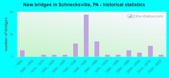
- New bridges - historical statistics
- 3Before 1900
- 11910-1919
- 11920-1929
- 11930-1939
- 61940-1949
- 191950-1959
- 71960-1969
- 11970-1979
- 11980-1989
- 31990-1999
- 22000-2009
- 52010-2019
- 12020-2022

- Reconstructed bridges - Historical Statistics
- 11950-1959
- 01960-1969
- 21970-1979
- 11980-1989
- 01990-1999
- 12000-2009
- 12010-2019


- Bridge Condition - Deck
- 10.3%Very good
- 17.2%Good
- 37.9%Satisfactory
- 24.1%Fair
- 10.3%Poor

- Bridge Condition - Superstructure
- 20.0%Very good
- 11.4%Good
- 37.1%Satisfactory
- 11.4%Fair
- 20.0%Poor

- Bridge Condition - Substructure
- 20.0%Very good
- 11.4%Good
- 37.1%Satisfactory
- 25.7%Fair
- 5.7%Poor

- Bridge Condition - Channel
- 11.4%Very good
- 11.4%Good
- 11.4%Satisfactory
- 54.3%Fair
- 11.4%Poor

- Bridge Condition - Culverts
- 14.3%Good
- 71.4%Satisfactory
- 14.3%Fair
Find on map >> Show street view
Structure Number: 54451, Location: HAAS BRIDGE (Lat: 40.614453, Lng: -75.621633), Route carried "on" structure: City street T574, Year Built: 2017, Status: Open, Structure Length: 1.10m (3.61ft), Average Daily Traffic: 140 (year 2014), Truck Traffic: 5%, Average Future Daily Traffic: 200 (year 2024), Design Load: HL 93, Features Intersected: HAASEN CREEK, Facility Carried by Structure: HICKORY LANE
Minimum Vertical Clearance: 30+ m (98+ ft), Kilometerpoint: 0.000, Lanes on structure: 2, Owner: County Highway Agency, Approaching Roadway Width: 4.3m (14.1ft), Material/Design: Concrete, Design/Construction: Arch - Deck, Number Of Spans In Main Unit: 1, Length of Maximum Span: 11.0m (36.1ft), Curb-To-Curb Width: 4.3m (14.1ft), Out-to-Out Width: 5.3m (17.4ft)
Condition: Superstructure: Very good, Substructure: Very good, Channel: Good, Operating Rating: 42.1 metric tons, Method Used To Determine Operating Rating: Assigned ratings based on Load and Resistance Factor Design (LRFD) reported by rating factor (RF) using HL93 loadings, Inventory Rating: 32.4 metric tons, Method Used To Determine Inventory Rating: Assigned ratings based on Load and Resistance Factor Design (LRFD) reported by rating factor (RF) using HL93 loadings, Structural Evaluation: Equal to present desirable criteria, Deck Geometry: High priority of replacement, Waterway Adequacy: Superior to present desirable criteria, Approach Roadway Alignment: Equal to present desirable criteria, Designated Inspection Frequency: Every 24 months, Inspection Date: August 2021
Find on map >> Show street view
Structure Number: 56731, Location: Bittners Corner (Lat: 40.657683, Lng: -75.683681), Route carried "on" structure: City street , Year Built: 2019, Status: Open, Structure Length: 1.83m (6.00ft), Average Daily Traffic: 100 (year 1980), Truck Traffic: 1%, Average Future Daily Traffic: 254 (year 2030), Design Load: HL 93, Features Intersected: Jordan Creek, Facility Carried by Structure: Bittners Corner Rd
Minimum Vertical Clearance: 30+ m (98+ ft), Kilometerpoint: 0.000, Lanes on structure: 1, Owner: County Highway Agency, Approaching Roadway Width: 6.7m (22.0ft), Material/Design: Concrete, Design/Construction: Arch - Deck, Number Of Spans In Main Unit: 1, Length of Maximum Span: 18.3m (60.0ft), Curb-To-Curb Width: 6.1m (20.0ft), Out-to-Out Width: 7.0m (23.0ft)
Condition: Superstructure: Very good, Substructure: Very good, Channel: Very good, Operating Rating: 36.3 metric tons, Method Used To Determine Operating Rating: Assigned ratings based on Load and Resistance Factor Design (LRFD) reported in metric tons, Inventory Rating: 30.8 metric tons, Method Used To Determine Inventory Rating: Assigned ratings based on Load and Resistance Factor Design (LRFD) reported in metric tons, Structural Evaluation: Better than present minimum criteria, Deck Geometry: Somewhat better than minimum adequacy, Waterway Adequacy: Superior to present desirable criteria, Approach Roadway Alignment: Equal to present desirable criteria, Designated Inspection Frequency: Every 24 months, Inspection Date: May 2021
Find on map >> Show street view
Structure Number: 68503, Location: SR 4009 (MILL CREEK RD) (Lat: 40.651406, Lng: -75.638542), Route carried "on" structure: City street , Year Built: 2021, Status: Open, Structure Length: 1.52m (4.99ft), Average Daily Traffic: 150 (year 2010), Truck Traffic: 1%, Average Future Daily Traffic: 160 (year 2020), Design Load: HL 93, Features Intersected: MILL CREEK, Facility Carried by Structure: BEAR ROAD
Minimum Vertical Clearance: 30+ m (98+ ft), Kilometerpoint: 0.000, Lanes on structure: 2, Owner: Town or Township Highway Agency, Approaching Roadway Width: 6.1m (20.0ft), Skew: 30 degrees, Material/Design: Concrete, Design/Construction: Arch - Deck, Number Of Spans In Main Unit: 1, Length of Maximum Span: 15.2m (49.9ft), Curb-To-Curb Width: 7.5m (24.6ft), Out-to-Out Width: 7.5m (24.6ft)
Condition: Superstructure: Very good, Substructure: Very good, Channel: Good, Operating Rating: 42.1 metric tons, Method Used To Determine Operating Rating: Assigned ratings based on Load and Resistance Factor Design (LRFD) reported by rating factor (RF) using HL93 loadings, Inventory Rating: 32.4 metric tons, Method Used To Determine Inventory Rating: Assigned ratings based on Load and Resistance Factor Design (LRFD) reported by rating factor (RF) using HL93 loadings, Structural Evaluation: Equal to present desirable criteria, Deck Geometry: Somewhat better than minimum adequacy, Waterway Adequacy: Equal to present desirable criteria, Approach Roadway Alignment: Equal to present desirable criteria, Designated Inspection Frequency: Every 24 months, Inspection Date: November 2021
Find on map >> Show street view
Structure Number: 23562, Location: NEAR ALLENTOWN,OREFIELD (Lat: 40.625000, Lng: -75.578333), Route carried "under" structure: City street , Year Built: 1955, Structure Length: 0. m, Average Daily Traffic: 200 (year 1992), Features Intersected: T-593; LIME KILN RD, Facility Carried by Structure: PA TPK (I-476)
Minimum Vertical Clearance: 4.40m (14.44ft), Kilometerpoint: 0.000, Lanes on structure: 4, Lanes under structure: 2, Toll: On toll road, Material/Design: Concrete, Design/Construction: Tee Beam, Length of Maximum Span: 10.4m (34.1ft)
Find on map >> Show street view
Structure Number: 23563, Location: NEAR ALLENTOWN,OREFIELD (Lat: 40.635844, Lng: -75.578889), Route carried "under" structure: Interstate 476, Year Built: 1955, Structure Length: 0. m, Average Daily Traffic: 30,563 (year 2004), Truck Traffic: 16%, Features Intersected: PA TPK (I-476), Facility Carried by Structure: SR4003,LR39042
Minimum Vertical Clearance: 4.65m (15.26ft), Kilometerpoint: 0.000, Lanes on structure: 2, Lanes under structure: 4, Material/Design: Steel, Design/Construction: Stringer/Multi-beam, Length of Maximum Span: 21.9m (71.9ft)
Find on map >> Show street view
Structure Number: 23564, Location: 6 MI NORTH OF ALLENTOWN (Lat: 40.646247, Lng: -75.584539), Route carried "under" structure: Interstate 476, Year Built: 1955, Structure Length: 0. m, Average Daily Traffic: 30,563 (year 2004), Truck Traffic: 16%, Features Intersected: PA TPK (I-476), Facility Carried by Structure: SR 4006,LR 39041
Minimum Vertical Clearance: 4.46m (14.63ft), Kilometerpoint: 0.000, Lanes on structure: 2, Lanes under structure: 4, Material/Design: Steel, Design/Construction: Stringer/Multi-beam, Length of Maximum Span: 27.4m (89.9ft)
Find on map >> Show street view
Structure Number: 23565, Location: WEST OF BALLIETTSVILLE (Lat: 40.655692, Lng: -75.589706), Route carried "under" structure: State highway , Year Built: 1955, Structure Length: 0. m, Average Daily Traffic: 3,680 (year 2022), Truck Traffic: 6%, Features Intersected: SR 4008, LR 39049, Facility Carried by Structure: PA TPK (I-476)
Minimum Vertical Clearance: 4.78m (15.68ft), Kilometerpoint: 0.929, Lanes on structure: 4, Lanes under structure: 2, Material/Design: Concrete, Design/Construction: Tee Beam, Length of Maximum Span: 12.8m (42.0ft)
Find on map >> Show street view
Structure Number: 23566, Location: WEST OF BALLIETTSVILLE (Lat: 40.669650, Lng: -75.596581), Route carried "under" structure: State highway , Year Built: 1955, Structure Length: 0. m, Average Daily Traffic: 3,767 (year 2022), Truck Traffic: 2%, Features Intersected: SR 4010, LR39091, Facility Carried by Structure: PA TPK (I-476)
Minimum Vertical Clearance: 9.90m (32.48ft), Kilometerpoint: 0.933, Lanes on structure: 4, Lanes under structure: 2, Material/Design: Steel, Design/Construction: Stringer/Multi-beam, Length of Maximum Span: 14.3m (46.9ft)
Find on map >> Show street view
Structure Number: 23567, Location: SOUTH OF NEFFS BOROUGH (Lat: 40.686667, Lng: -75.601667), Route carried "under" structure: City street , Year Built: 1955, Structure Length: 0. m, Average Daily Traffic: 200 (year 1992), Features Intersected: T-665, Facility Carried by Structure: PA TPK (I-476)
Minimum Vertical Clearance: 7.49m (24.57ft), Kilometerpoint: 0.000, Lanes on structure: 4, Lanes under structure: 2, Toll: On toll road, Material/Design: Steel, Design/Construction: Stringer/Multi-beam, Length of Maximum Span: 11.6m (38.1ft)
Find on map >> Show street view
Structure Number: 23568, Location: NEAR NEFFS BOROUGH (Lat: 40.686478, Lng: -75.601764), Route carried "under" structure: State highway 329, Year Built: 1955, Structure Length: 0. m, Average Daily Traffic: 3,991 (year 2022), Truck Traffic: 5%, Features Intersected: SR 0329, LR39038, Facility Carried by Structure: PA TPK (I-476)
Minimum Vertical Clearance: 4.50m (14.76ft), Kilometerpoint: 0.715, Lanes on structure: 4, Lanes under structure: 2, Material/Design: Steel, Design/Construction: Stringer/Multi-beam, Length of Maximum Span: 22.3m (73.2ft)
Find on map >> Show street view
Structure Number: 23569, Location: AT NEFFS BOROUGH (Lat: 40.693058, Lng: -75.603756), Route carried "under" structure: State highway , Year Built: 1955, Structure Length: 0. m, Average Daily Traffic: 1,788 (year 2020), Truck Traffic: 4%, Features Intersected: SR 4014, Facility Carried by Structure: PA TPK (I-476)
Minimum Vertical Clearance: 5.22m (17.13ft), Kilometerpoint: 10.855, Lanes on structure: 4, Lanes under structure: 2, Material/Design: Concrete, Design/Construction: Tee Beam, Length of Maximum Span: 9.1m (29.9ft)
Find on map >> Show street view
Structure Number: 2357, Location: NORTH OF NEFFS BOROUGH (Lat: 40.703653, Lng: -75.610431), Route carried "under" structure: City street , Year Built: 1955, Structure Length: 0. m, Average Daily Traffic: 200 (year 1992), Features Intersected: T-707; GLENCREST ROAD, Facility Carried by Structure: PA TPK (I-476)
Minimum Vertical Clearance: 5.42m (17.78ft), Kilometerpoint: 0.000, Lanes on structure: 4, Lanes under structure: 2, Toll: On toll road, Material/Design: Concrete, Design/Construction: Tee Beam, Length of Maximum Span: 8.5m (27.9ft)