Bridge Statistics for Selma, Alabama (AL)
Condition, Traffic, Stress, Structural Evaluation, Project Costs
- National Bridge Inventory (NBI) Statistics
- 37Number of bridges
- 574ft / 175mTotal length
- $65,024,000Total costs
- 237,433Total average daily traffic
- 27,280Total average daily truck traffic
- National Bridge Inventory (NBI) Registered Bridges for Selma
- No street view available for this location
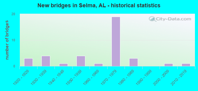
- New bridges - historical statistics
- 31920-1929
- 41930-1939
- 11940-1949
- 41950-1959
- 11960-1969
- 191970-1979
- 31980-1989
- 12000-2009
- 12010-2019
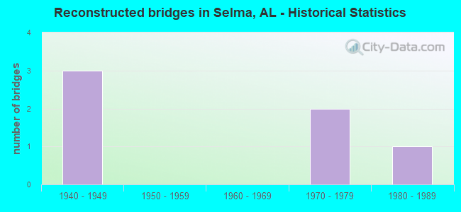
- Reconstructed bridges - Historical Statistics
- 31940-1949
- 01950-1959
- 01960-1969
- 21970-1979
- 11980-1989
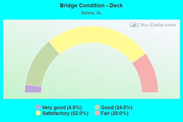
- Bridge Condition - Deck
- 4.0%Very good
- 24.0%Good
- 52.0%Satisfactory
- 20.0%Fair
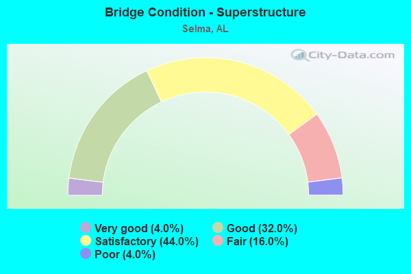
- Bridge Condition - Superstructure
- 4.0%Very good
- 32.0%Good
- 44.0%Satisfactory
- 16.0%Fair
- 4.0%Poor
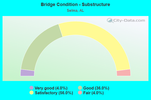
- Bridge Condition - Substructure
- 4.0%Very good
- 36.0%Good
- 56.0%Satisfactory
- 4.0%Fair
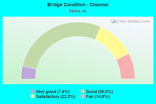
- Bridge Condition - Channel
- 7.4%Very good
- 55.6%Good
- 22.2%Satisfactory
- 14.8%Fair
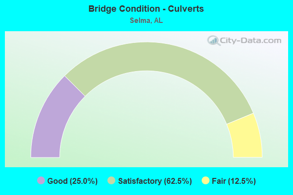
- Bridge Condition - Culverts
- 25.0%Good
- 62.5%Satisfactory
- 12.5%Fair
Find on map >> Show street view
Structure Number: 1556, Location: 1.1 MI.E.OF SOU.RR (Lat: 32.433333, Lng: -86.935000), Route carried "on" structure: State highway 14, Year Built: 1937, Status: Open, Structure Length: 1.37m (4.49ft), Average Daily Traffic: 5,720 (year 2013), Truck Traffic: 12%, Average Future Daily Traffic: 7,704 (year 2033), Design Load: H 15, Features Intersected: BLUE GIRTH SWAMP
Minimum Vertical Clearance: 30+ m (98+ ft), Kilometerpoint: 195.611, Lanes on structure: 2, Owner: State Highway Agency, Approaching Roadway Width: 8.2m (26.9ft), Material/Design: Steel continuous, Design/Construction: Stringer/Multi-beam, Number Of Spans In Main Unit: 2, Length of Maximum Span: 6.7m (22.0ft), Curb-To-Curb Width: 7.3m (24.0ft), Out-to-Out Width: 7.6m (24.9ft)
Condition: Deck: Satisfactory, Superstructure: Satisfactory, Substructure: Satisfactory, Channel: Good, Operating Rating: 67.0 metric tons, Method Used To Determine Operating Rating: Load Factor (LF), Inventory Rating: 40.1 metric tons, Method Used To Determine Inventory Rating: Load Factor (LF), Structural Evaluation: Equal to present minimum criteria, Deck Geometry: High priority of replacement, Waterway Adequacy: Better than present minimum criteria, Approach Roadway Alignment: Better than present minimum criteria, Length Of Structure Improvement: 2.04m (6.69ft), Designated Inspection Frequency: Every 24 months, Underwater Inspection Frequency: Every 24 months, Inspection Date: April 2020, Underwater Inspection Date: April 2020, Bridge Improvement Cost: $336,000, Roadway Improvement Cost: $34,000, Total Project Cost: $370,000 ( Estimate for 2022), Deck Structure Type: Concrete Cast-file-Place
Find on map >> Show street view
Structure Number: 1557, Location: 1.3 MI.E.OF SOU.RR (Lat: 32.435000, Lng: -86.933333), Route carried "on" structure: State highway 14, Year Built: 1937, Status: Open, Structure Length: 1.37m (4.49ft), Average Daily Traffic: 5,720 (year 2013), Truck Traffic: 12%, Average Future Daily Traffic: 7,704 (year 2033), Design Load: H 15, Features Intersected: BLUE GIRTH SWAMP
Minimum Vertical Clearance: 30+ m (98+ ft), Kilometerpoint: 195.931, Lanes on structure: 2, Owner: State Highway Agency, Approaching Roadway Width: 9.8m (32.2ft), Material/Design: Steel, Design/Construction: Stringer/Multi-beam, Number Of Spans In Main Unit: 2, Length of Maximum Span: 6.7m (22.0ft), Curb-To-Curb Width: 7.3m (24.0ft), Out-to-Out Width: 7.6m (24.9ft)
Condition: Deck: Fair, Superstructure: Fair, Substructure: Satisfactory, Channel: Satisfactory, Operating Rating: 63.0 metric tons, Method Used To Determine Operating Rating: Load Factor (LF), Inventory Rating: 37.7 metric tons, Method Used To Determine Inventory Rating: Load Factor (LF), Structural Evaluation: Somewhat better than minimum adequacy, Deck Geometry: High priority of replacement, Waterway Adequacy: Better than present minimum criteria, Approach Roadway Alignment: Better than present minimum criteria, Length Of Structure Improvement: 2.04m (6.69ft), Designated Inspection Frequency: Every 24 months, Inspection Date: April 2020, Bridge Improvement Cost: $336,000, Roadway Improvement Cost: $34,000, Total Project Cost: $370,000 ( Estimate for 2022), Deck Structure Type: Concrete Cast-file-Place
Find on map >> Show street view
Structure Number: 2812, Location: INTER.CAHABA RD. (Lat: 32.416908, Lng: -87.050000), Route carried "on" structure: City street 2, Year Built: 1945, Status: Open, Structure Length: 0.97m (3.18ft), Average Daily Traffic: 7,211 (year 2006), Truck Traffic: 1%, Average Future Daily Traffic: 10,095 (year 2041), Design Load: H 15, Features Intersected: JONES CREEK, Facility Carried by Structure: CAHABA ROAD
Minimum Vertical Clearance: 30+ m (98+ ft), Kilometerpoint: 0.010, Lanes on structure: 2, Owner: City or Municipal Highway Agency, Approaching Roadway Width: 8.8m (28.9ft), Material/Design: Concrete, Design/Construction: Culvert, Number Of Spans In Main Unit: 3, Length of Maximum Span: 3.0m (9.8ft), Out-to-Out Width: 15.8m (51.8ft)
Condition: Channel: Good, Culverts: Fair, Operating Rating: 32.7 metric tons, Method Used To Determine Operating Rating: Field evaluation and documented engineering judgment, Inventory Rating: 23.6 metric tons, Method Used To Determine Inventory Rating: Field evaluation and documented engineering judgment, Structural Evaluation: Somewhat better than minimum adequacy, Waterway Adequacy: Equal to present desirable criteria, Approach Roadway Alignment: Equal to present minimum criteria, Length Of Structure Improvement: 1.64m (5.38ft), Designated Inspection Frequency: Every 24 months, Inspection Date: July 2021, Bridge Improvement Cost: $313,000, Roadway Improvement Cost: $31,000, Total Project Cost: $344,000 ( Estimate for 2022)
Find on map >> Show street view
Structure Number: 2982, Location: 0.2 MI.W.JCT US 80 (Lat: 32.436667, Lng: -87.063333), Route carried "on" structure: State highway 14, Year Built: 1926, Year Reconstructed: 1947, Status: Open, Structure Length: 0.67m (2.20ft), Average Daily Traffic: 3,210 (year 2013), Truck Traffic: 8%, Average Future Daily Traffic: 4,323 (year 2033), Design Load: H 15, Features Intersected: STREAM
Minimum Vertical Clearance: 30+ m (98+ ft), Kilometerpoint: 183.439, Lanes on structure: 2, Owner: State Highway Agency, Approaching Roadway Width: 12.2m (40.0ft), Material/Design: Concrete continuous, Design/Construction: Culvert, Number Of Spans In Main Unit: 2, Length of Maximum Span: 3.0m (9.8ft)
Condition: Channel: Satisfactory, Culverts: Satisfactory, Operating Rating: 72.8 metric tons, Method Used To Determine Operating Rating: Load Factor (LF), Inventory Rating: 43.6 metric tons, Method Used To Determine Inventory Rating: Load Factor (LF), Structural Evaluation: Equal to present minimum criteria, Waterway Adequacy: Superior to present desirable criteria, Approach Roadway Alignment: Better than present minimum criteria, Length Of Structure Improvement: 1.30m (4.27ft), Designated Inspection Frequency: Every 24 months, Inspection Date: Febuary 2022, Bridge Improvement Cost: $428,000, Roadway Improvement Cost: $43,000, Total Project Cost: $471,000 ( Estimate for 2022)
Find on map >> Show street view
Structure Number: 4569, Location: 2.0 MI.E.JCT US.80 (Lat: 32.431667, Lng: -86.990000), Route carried "on" structure: State highway 14, Year Built: 1953, Status: Open, Structure Length: 0.64m (2.10ft), Average Daily Traffic: 5,930 (year 2013), Truck Traffic: 12%, Average Future Daily Traffic: 7,987 (year 2033), Design Load: H 15, Features Intersected: STREAM
Minimum Vertical Clearance: 30+ m (98+ ft), Kilometerpoint: 190.345, Lanes on structure: 2, Owner: State Highway Agency, Approaching Roadway Width: 13.4m (44.0ft), Material/Design: Concrete continuous, Design/Construction: Culvert, Number Of Spans In Main Unit: 3, Length of Maximum Span: 1.8m (5.9ft)
Condition: Channel: Satisfactory, Culverts: Satisfactory, Operating Rating: 36.9 metric tons, Method Used To Determine Operating Rating: Load Factor (LF), Inventory Rating: 22.1 metric tons, Method Used To Determine Inventory Rating: Load Factor (LF), Structural Evaluation: Somewhat better than minimum adequacy, Waterway Adequacy: Better than present minimum criteria, Approach Roadway Alignment: Better than present minimum criteria, Length Of Structure Improvement: 1.26m (4.13ft), Designated Inspection Frequency: Every 24 months, Underwater Inspection Frequency: Every 24 months, Inspection Date: April 2020, Underwater Inspection Date: April 2020, Bridge Improvement Cost: $364,000, Roadway Improvement Cost: $36,000, Total Project Cost: $400,000 ( Estimate for 2022)
Find on map >> Show street view
Structure Number: 4571, Location: JCT.OF AL.14 AND SO.RR (Lat: 32.430000, Lng: -86.955000), Route carried "on" structure: State highway 14, Year Built: 1953, Status: Open, Structure Length: 5.73m (18.80ft), Average Daily Traffic: 5,930 (year 2013), Truck Traffic: 12%, Average Future Daily Traffic: 7,987 (year 2033), Design Load: H 20, Features Intersected: SOU.RR
Minimum Vertical Clearance: 30+ m (98+ ft), Kilometerpoint: 193.768, Lanes on structure: 2, Owner: State Highway Agency, Approaching Roadway Width: 13.4m (44.0ft), Skew: 2 degrees, Material/Design: Concrete, Design/Construction: Tee Beam, Number Of Spans In Main Unit: 5, Length of Maximum Span: 15.8m (51.8ft), Curb-To-Curb Width: 8.5m (27.9ft), Out-to-Out Width: 9.4m (30.8ft)
Condition: Deck: Satisfactory, Superstructure: Satisfactory, Substructure: Satisfactory, Operating Rating: 43.9 metric tons, Method Used To Determine Operating Rating: Load Factor (LF), Inventory Rating: 26.3 metric tons, Method Used To Determine Inventory Rating: Load Factor (LF), Structural Evaluation: Equal to present minimum criteria, Deck Geometry: High priority of replacement, Underclear: High priority of corrective action, Approach Roadway Alignment: Better than present minimum criteria, Length Of Structure Improvement: 6.77m (22.21ft), Designated Inspection Frequency: Every 24 months, Inspection Date: Febuary 2022, Bridge Improvement Cost: $1,392,000, Roadway Improvement Cost: $139,000, Total Project Cost: $1,531,000 ( Estimate for 2022), Deck Structure Type: Concrete Cast-file-Place
Find on map >> Show street view
Structure Number: 466, Location: 0.3 MI W SR 41 (Lat: 32.401397, Lng: -86.997817), Route carried "on" structure: County highway 80, Year Built: 1953, Status: Posted for load, Structure Length: 11.16m (36.61ft), Average Daily Traffic: 1,050 (year 2012), Truck Traffic: 15%, Average Future Daily Traffic: 1,300 (year 2040), Design Load: H 15, Features Intersected: BEECH CREEK, Facility Carried by Structure: HARRISON AVENUE
Minimum Vertical Clearance: 30+ m (98+ ft), Kilometerpoint: 0.010, Lanes on structure: 2, Owner: County Highway Agency, Approaching Roadway Width: 6.1m (20.0ft), Material/Design: Concrete continuous, Design/Construction: Tee Beam, Number Of Spans In Main Unit: 3, Number Of Approach Spans: 6, Length of Maximum Span: 18.3m (60.0ft), Curb or Sidewalk Widths: Left: 0.3m (1.0ft), Right: 0.3m (1.0ft), Curb-To-Curb Width: 6.6m (21.7ft), Out-to-Out Width: 7.1m (23.3ft)
Condition: Deck: Fair, Superstructure: Poor, Substructure: Fair, Channel: Satisfactory, Operating Rating: 13.6 metric tons, Method Used To Determine Operating Rating: Load Factor (LF), Inventory Rating: 9.1 metric tons, Method Used To Determine Inventory Rating: Load Factor (LF), Structural Evaluation: High priority of replacement, Deck Geometry: High priority of replacement, Waterway Adequacy: Better than present minimum criteria, Approach Roadway Alignment: Equal to present minimum criteria, Bridge Posting: Required (Relationship of Operating Rating to Maximum Legal Load: > 39.9% below), Length Of Structure Improvement: 12.05m (39.53ft), Designated Inspection Frequency: Every 24 months, Other Special Inspection Frequency: Every 6 months, Inspection Date: October 2021, Other Special Inspection Date: October 2021, Bridge Improvement Cost: $1,900,000, Roadway Improvement Cost: $190,000, Total Project Cost: $2,090,000 ( Estimate for 2022), Deck Structure Type: Concrete Cast-file-Place
Find on map >> Show street view
Structure Number: 4714, Location: 0.1MI.E.AL.219 (Lat: 32.385992, Lng: -87.084367), Route carried "on" structure: State highway 22, Year Built: 1927, Year Reconstructed: 1954, Status: Open, Structure Length: 0.70m (2.30ft), Average Daily Traffic: 5,230 (year 2013), Truck Traffic: 3%, Average Future Daily Traffic: 6,344 (year 2033), Design Load: H 15, Features Intersected: BRANCH
Minimum Vertical Clearance: 30+ m (98+ ft), Kilometerpoint: 30.980, Lanes on structure: 4, Owner: State Highway Agency, Approaching Roadway Width: 15.8m (51.8ft), Material/Design: Concrete continuous, Design/Construction: Culvert, Number Of Spans In Main Unit: 2, Length of Maximum Span: 3.0m (9.8ft)
Condition: Channel: Fair, Culverts: Satisfactory, Operating Rating: 88.9 metric tons, Method Used To Determine Operating Rating: Load Factor (LF), Inventory Rating: 88.9 metric tons, Method Used To Determine Inventory Rating: Load Factor (LF), Structural Evaluation: Equal to present minimum criteria, Waterway Adequacy: Somewhat better than minimum adequacy, Approach Roadway Alignment: Better than present minimum criteria, Length Of Structure Improvement: 1.34m (4.40ft), Designated Inspection Frequency: Every 24 months, Inspection Date: November 2020, Bridge Improvement Cost: $711,000, Roadway Improvement Cost: $71,000, Total Project Cost: $782,000 ( Estimate for 2022)
Find on map >> Show street view
Structure Number: 4715, Location: 2.5 MI. E.AL.219 (Lat: 32.406667, Lng: -87.048333), Route carried "on" structure: State highway 22, Year Built: 1927, Year Reconstructed: 1954, Status: Open, Structure Length: 1.01m (3.31ft), Average Daily Traffic: 8,450 (year 2013), Truck Traffic: 2%, Average Future Daily Traffic: 10,250 (year 2033), Design Load: H 15, Features Intersected: JONES CREEK
Minimum Vertical Clearance: 30+ m (98+ ft), Kilometerpoint: 35.163, Lanes on structure: 4, Owner: State Highway Agency, Approaching Roadway Width: 15.8m (51.8ft), Material/Design: Concrete continuous, Design/Construction: Culvert, Number Of Spans In Main Unit: 3, Length of Maximum Span: 3.0m (9.8ft)
Condition: Channel: Fair, Culverts: Good, Operating Rating: 88.9 metric tons, Method Used To Determine Operating Rating: Load Factor (LF), Inventory Rating: 88.9 metric tons, Method Used To Determine Inventory Rating: Load Factor (LF), Structural Evaluation: Better than present minimum criteria, Waterway Adequacy: Better than present minimum criteria, Approach Roadway Alignment: Better than present minimum criteria, Length Of Structure Improvement: 1.68m (5.51ft), Designated Inspection Frequency: Every 24 months, Inspection Date: August 2021, Bridge Improvement Cost: $670,000, Roadway Improvement Cost: $67,000, Total Project Cost: $737,000 ( Estimate for 2022)
Find on map >> Show street view
Structure Number: 8344, Location: 1.05 MI W SR 219 (Lat: 32.426264, Lng: -87.099764), Route carried "on" structure: County highway 44, Year Built: 1964, Status: Open, Structure Length: 1.89m (6.20ft), Average Daily Traffic: 711 (year 2005), Truck Traffic: 7%, Average Future Daily Traffic: 1,100 (year 2037), Design Load: H 15, Features Intersected: CHILDERS CREEK
Minimum Vertical Clearance: 30+ m (98+ ft), Kilometerpoint: 0.010, Lanes on structure: 2, Owner: County Highway Agency, Approaching Roadway Width: 7.3m (24.0ft), Material/Design: Steel, Design/Construction: Stringer/Multi-beam, Number Of Spans In Main Unit: 3, Length of Maximum Span: 5.5m (18.0ft), Curb or Sidewalk Widths: Left: 0.3m (1.0ft), Right: 0.3m (1.0ft), Curb-To-Curb Width: 6.6m (21.7ft), Out-to-Out Width: 7.1m (23.3ft)
Condition: Deck: Fair, Superstructure: Satisfactory, Substructure: Satisfactory, Channel: Satisfactory, Operating Rating: 41.7 metric tons, Method Used To Determine Operating Rating: Load Factor (LF), Inventory Rating: 31.5 metric tons, Method Used To Determine Inventory Rating: Load Factor (LF), Structural Evaluation: Equal to present minimum criteria, Deck Geometry: High priority of corrective action, Waterway Adequacy: Better than present minimum criteria, Approach Roadway Alignment: Better than present minimum criteria, Length Of Structure Improvement: 2.62m (8.60ft), Designated Inspection Frequency: Every 24 months, Inspection Date: October 2021, Bridge Improvement Cost: $413,000, Roadway Improvement Cost: $41,000, Total Project Cost: $454,000 ( Estimate for 2022), Deck Structure Type: Concrete Cast-file-Place
Find on map >> Show street view
Structure Number: 10341, Location: 1.4 MI.N.OF US 80 (Lat: 32.406783, Lng: -86.994167), Route carried "on" structure: State highway 41, Year Built: 1970, Status: Open, Structure Length: 7.25m (23.79ft), Average Daily Traffic: 10,540 (year 2013), Truck Traffic: 17%, Average Future Daily Traffic: 13,066 (year 2033), Design Load: HS 20, Features Intersected: ALA. RIVER RELIEF #1
Minimum Vertical Clearance: 30+ m (98+ ft), Kilometerpoint: 200.103, Lanes on structure: 2, Owner: State Highway Agency, Approaching Roadway Width: 13.4m (44.0ft), Material/Design: Concrete, Design/Construction: Tee Beam, Number Of Spans In Main Unit: 7, Length of Maximum Span: 10.4m (34.1ft), Curb-To-Curb Width: 11.9m (39.0ft), Out-to-Out Width: 13.0m (42.7ft)
Condition: Deck: Fair, Superstructure: Fair, Substructure: Satisfactory, Channel: Good, Operating Rating: 49.9 metric tons, Method Used To Determine Operating Rating: Load Factor (LF), Inventory Rating: 30.0 metric tons, Method Used To Determine Inventory Rating: Load Factor (LF), Structural Evaluation: Somewhat better than minimum adequacy, Deck Geometry: Somewhat better than minimum adequacy, Waterway Adequacy: Superior to present desirable criteria, Approach Roadway Alignment: Better than present minimum criteria, Length Of Structure Improvement: 8.28m (27.17ft), Designated Inspection Frequency: Every 24 months, Inspection Date: October 2020, Bridge Improvement Cost: $2,384,000, Roadway Improvement Cost: $238,000, Total Project Cost: $2,622,000 ( Estimate for 2022), Deck Structure Type: Concrete Cast-file-Place
Find on map >> Show street view
Structure Number: 10342, Location: 1.7 MI.N OF US 80 (Lat: 32.393750, Lng: -86.992750), Route carried "on" structure: State highway 41, Year Built: 1970, Status: Open, Structure Length: 7.25m (23.79ft), Average Daily Traffic: 10,540 (year 2013), Truck Traffic: 17%, Average Future Daily Traffic: 13,066 (year 2033), Design Load: HS 20, Features Intersected: ALA. RIVER RELIEF #2
Minimum Vertical Clearance: 30+ m (98+ ft), Kilometerpoint: 200.527, Lanes on structure: 2, Owner: State Highway Agency, Approaching Roadway Width: 13.4m (44.0ft), Material/Design: Concrete, Design/Construction: Tee Beam, Number Of Spans In Main Unit: 7, Length of Maximum Span: 10.4m (34.1ft), Curb-To-Curb Width: 11.9m (39.0ft), Out-to-Out Width: 13.0m (42.7ft)
Condition: Deck: Satisfactory, Superstructure: Fair, Substructure: Satisfactory, Channel: Good, Operating Rating: 49.9 metric tons, Method Used To Determine Operating Rating: Load Factor (LF), Inventory Rating: 30.0 metric tons, Method Used To Determine Inventory Rating: Load Factor (LF), Structural Evaluation: Somewhat better than minimum adequacy, Deck Geometry: Somewhat better than minimum adequacy, Waterway Adequacy: Superior to present desirable criteria, Approach Roadway Alignment: Better than present minimum criteria, Length Of Structure Improvement: 8.28m (27.17ft), Designated Inspection Frequency: Every 24 months, Inspection Date: October 2020, Bridge Improvement Cost: $2,384,000, Roadway Improvement Cost: $238,000, Total Project Cost: $2,622,000 ( Estimate for 2022), Deck Structure Type: Concrete Cast-file-Place
Find on map >> Show street view
Structure Number: 10343, Location: 1.9 MI.N.OF US 80 (Lat: 32.408333, Lng: -86.991667), Route carried "on" structure: State highway 41, Year Built: 1970, Status: Open, Structure Length: 9.33m (30.61ft), Average Daily Traffic: 10,540 (year 2013), Truck Traffic: 17%, Average Future Daily Traffic: 13,066 (year 2033), Design Load: HS 20, Features Intersected: ALA. RIVER RELIEF #3
Minimum Vertical Clearance: 30+ m (98+ ft), Kilometerpoint: 200.832, Lanes on structure: 2, Owner: State Highway Agency, Approaching Roadway Width: 13.4m (44.0ft), Material/Design: Concrete, Design/Construction: Tee Beam, Number Of Spans In Main Unit: 9, Length of Maximum Span: 10.4m (34.1ft), Curb-To-Curb Width: 11.9m (39.0ft), Out-to-Out Width: 13.0m (42.7ft)
Condition: Deck: Satisfactory, Superstructure: Fair, Substructure: Satisfactory, Channel: Good, Operating Rating: 49.9 metric tons, Method Used To Determine Operating Rating: Load Factor (LF), Inventory Rating: 30.0 metric tons, Method Used To Determine Inventory Rating: Load Factor (LF), Structural Evaluation: Somewhat better than minimum adequacy, Deck Geometry: Somewhat better than minimum adequacy, Waterway Adequacy: Superior to present desirable criteria, Approach Roadway Alignment: Better than present minimum criteria, Length Of Structure Improvement: 10.29m (33.76ft), Designated Inspection Frequency: Every 24 months, Inspection Date: October 2020, Bridge Improvement Cost: $2,963,000, Roadway Improvement Cost: $296,000, Total Project Cost: $3,259,000 ( Estimate for 2022), Deck Structure Type: Concrete Cast-file-Place
Find on map >> Show street view
Structure Number: 10913, Location: BET. AL. 22 AND MARINA ST (Lat: 32.083333, Lng: -87.050000), Route carried "on" structure: City street 1, Year Built: 1973, Status: Posted for load, Structure Length: 5.18m (16.99ft), Average Daily Traffic: 122 (year 2006), Truck Traffic: 1%, Average Future Daily Traffic: 239 (year 2041), Design Load: H 15, Features Intersected: JONES CREEK, Facility Carried by Structure: MARINA DR
Minimum Vertical Clearance: 30+ m (98+ ft), Kilometerpoint: 0.100, Lanes on structure: 2, Owner: City or Municipal Highway Agency, Approaching Roadway Width: 7.3m (24.0ft), Material/Design: Concrete, Design/Construction: Tee Beam, Number Of Spans In Main Unit: 5, Length of Maximum Span: 10.4m (34.1ft), Curb-To-Curb Width: 6.7m (22.0ft), Out-to-Out Width: 7.6m (24.9ft)
Condition: Deck: Good, Superstructure: Good, Substructure: Good, Channel: Good, Operating Rating: 34.7 metric tons, Method Used To Determine Operating Rating: Load Factor (LF), Inventory Rating: 20.8 metric tons, Method Used To Determine Inventory Rating: Load Factor (LF), Structural Evaluation: Equal to present minimum criteria, Deck Geometry: Meets minimum limits, Waterway Adequacy: Better than present minimum criteria, Approach Roadway Alignment: Better than present minimum criteria, Bridge Posting: Required (Relationship of Operating Rating to Maximum Legal Load: 10.0 - 19.9% below), Length Of Structure Improvement: 6.20m (20.34ft), Designated Inspection Frequency: Every 24 months, Other Special Inspection Frequency: Every 12 months, Inspection Date: July 2021, Other Special Inspection Date: July 2021, Bridge Improvement Cost: $1,021,000, Roadway Improvement Cost: $102,000, Total Project Cost: $1,123,000 ( Estimate for 2022), Deck Structure Type: Concrete Cast-file-Place
Find on map >> Show street view
Structure Number: 10924, Location: 0.35 MI.N.OF OLD CAHABA R (Lat: 32.416667, Lng: -87.050000), Route carried "on" structure: City street 3, Year Built: 1973, Status: Open, Structure Length: 6.34m (20.80ft), Average Daily Traffic: 7,815 (year 2006), Truck Traffic: 1%, Average Future Daily Traffic: 10,941 (year 2041), Design Load: H 15, Features Intersected: SOUTHERN R.R., Facility Carried by Structure: MEDICAL CENTERPKW
Minimum Vertical Clearance: 30+ m (98+ ft), Kilometerpoint: 0.349, Lanes on structure: 4, Owner: City or Municipal Highway Agency, Approaching Roadway Width: 18.3m (60.0ft), Skew: 2 degrees, Material/Design: Steel, Design/Construction: Stringer/Multi-beam, Number Of Spans In Main Unit: 1, Number Of Approach Spans: 4, Length of Maximum Span: 21.9m (71.9ft), Curb-To-Curb Width: 13.4m (44.0ft), Out-to-Out Width: 14.5m (47.6ft)
Condition: Deck: Good, Superstructure: Good, Substructure: Good, Operating Rating: 46.3 metric tons, Method Used To Determine Operating Rating: Load Factor (LF), Inventory Rating: 27.8 metric tons, Method Used To Determine Inventory Rating: Load Factor (LF), Structural Evaluation: Equal to present minimum criteria, Deck Geometry: High priority of replacement, Underclear: Equal to present minimum criteria, Approach Roadway Alignment: Equal to present desirable criteria, Length Of Structure Improvement: 7.38m (24.21ft), Designated Inspection Frequency: Every 24 months, Inspection Date: January 2021, Bridge Improvement Cost: $2,378,000, Roadway Improvement Cost: $238,000, Total Project Cost: $2,616,000 ( Estimate for 2022), Deck Structure Type: Concrete Cast-file-Place
Find on map >> Show street view
Structure Number: 11217, Location: 7.3 MI.W.OF US 80 (Lat: 32.362592, Lng: -87.126686), Route carried "on" structure: State highway 22, Year Built: 1974, Status: Open, Structure Length: 7.25m (23.79ft), Average Daily Traffic: 4,050 (year 2013), Truck Traffic: 9%, Average Future Daily Traffic: 4,912 (year 2033), Design Load: HS 20, Features Intersected: CAHABA RIVER RELIEF #1
Minimum Vertical Clearance: 30+ m (98+ ft), Kilometerpoint: 26.067, Lanes on structure: 2, Owner: State Highway Agency, Approaching Roadway Width: 13.4m (44.0ft), Material/Design: Concrete, Design/Construction: Tee Beam, Number Of Spans In Main Unit: 7, Length of Maximum Span: 10.4m (34.1ft), Curb-To-Curb Width: 8.5m (27.9ft), Out-to-Out Width: 9.4m (30.8ft)
Condition: Deck: Satisfactory, Superstructure: Satisfactory, Substructure: Satisfactory, Channel: Good, Operating Rating: 44.2 metric tons, Method Used To Determine Operating Rating: Load Factor (LF), Inventory Rating: 26.5 metric tons, Method Used To Determine Inventory Rating: Load Factor (LF), Structural Evaluation: Equal to present minimum criteria, Deck Geometry: Meets minimum limits, Waterway Adequacy: Better than present minimum criteria, Approach Roadway Alignment: Better than present minimum criteria, Length Of Structure Improvement: 8.28m (27.17ft), Designated Inspection Frequency: Every 24 months, Inspection Date: November 2020, Bridge Improvement Cost: $1,703,000, Roadway Improvement Cost: $170,000, Total Project Cost: $1,873,000 ( Estimate for 2022), Deck Structure Type: Concrete Cast-file-Place
Find on map >> Show street view
Structure Number: 11218, Location: 7.1 MI.W.OF US 80 (Lat: 32.365947, Lng: -87.115581), Route carried "on" structure: State highway 22, Year Built: 1974, Status: Open, Structure Length: 5.18m (16.99ft), Average Daily Traffic: 4,050 (year 2013), Truck Traffic: 9%, Average Future Daily Traffic: 4,912 (year 2033), Design Load: HS 20, Features Intersected: CAHABA RIVER RELIEF #2
Minimum Vertical Clearance: 30+ m (98+ ft), Kilometerpoint: 27.246, Lanes on structure: 2, Owner: State Highway Agency, Approaching Roadway Width: 13.4m (44.0ft), Material/Design: Concrete, Design/Construction: Tee Beam, Number Of Spans In Main Unit: 5, Length of Maximum Span: 10.4m (34.1ft), Curb-To-Curb Width: 8.5m (27.9ft), Out-to-Out Width: 9.4m (30.8ft)
Condition: Deck: Satisfactory, Superstructure: Satisfactory, Substructure: Good, Channel: Good, Operating Rating: 44.2 metric tons, Method Used To Determine Operating Rating: Load Factor (LF), Inventory Rating: 26.5 metric tons, Method Used To Determine Inventory Rating: Load Factor (LF), Structural Evaluation: Equal to present minimum criteria, Deck Geometry: Meets minimum limits, Waterway Adequacy: Better than present minimum criteria, Approach Roadway Alignment: Better than present minimum criteria, Length Of Structure Improvement: 6.20m (20.34ft), Designated Inspection Frequency: Every 24 months, Inspection Date: November 2020, Bridge Improvement Cost: $1,276,000, Roadway Improvement Cost: $128,000, Total Project Cost: $1,404,000 ( Estimate for 2022), Deck Structure Type: Concrete Cast-file-Place
Find on map >> Show street view
Structure Number: 11219, Location: 6.2 MI.W.OF US 80 (Lat: 32.367911, Lng: -87.109761), Route carried "on" structure: State highway 22, Year Built: 1974, Status: Open, Structure Length: 4.15m (13.62ft), Average Daily Traffic: 4,050 (year 2013), Truck Traffic: 9%, Average Future Daily Traffic: 4,912 (year 2033), Design Load: HS 20, Features Intersected: CAHABA RIVER RELIEF#3
Minimum Vertical Clearance: 30+ m (98+ ft), Kilometerpoint: 27.800, Lanes on structure: 2, Owner: State Highway Agency, Approaching Roadway Width: 13.4m (44.0ft), Material/Design: Concrete, Design/Construction: Tee Beam, Number Of Spans In Main Unit: 4, Length of Maximum Span: 10.4m (34.1ft), Curb-To-Curb Width: 8.5m (27.9ft), Out-to-Out Width: 9.4m (30.8ft)
Condition: Deck: Good, Superstructure: Good, Substructure: Good, Channel: Good, Operating Rating: 44.2 metric tons, Method Used To Determine Operating Rating: Load Factor (LF), Inventory Rating: 26.5 metric tons, Method Used To Determine Inventory Rating: Load Factor (LF), Structural Evaluation: Equal to present minimum criteria, Deck Geometry: Meets minimum limits, Waterway Adequacy: Better than present minimum criteria, Approach Roadway Alignment: Better than present minimum criteria, Length Of Structure Improvement: 5.12m (16.80ft), Designated Inspection Frequency: Every 24 months, Inspection Date: December 2020, Bridge Improvement Cost: $1,053,000, Roadway Improvement Cost: $105,000, Total Project Cost: $1,158,000 ( Estimate for 2022), Deck Structure Type: Concrete Cast-file-Place
Find on map >> Show street view
Structure Number: 1122, Location: 5.7MI.W.US80 (Lat: 32.372158, Lng: -87.101794), Route carried "on" structure: State highway 22, Year Built: 1974, Status: Open, Structure Length: 6.22m (20.41ft), Average Daily Traffic: 4,050 (year 2013), Truck Traffic: 9%, Average Future Daily Traffic: 4,912 (year 2033), Design Load: HS 20, Features Intersected: CHILDERS CREEK
Minimum Vertical Clearance: 30+ m (98+ ft), Kilometerpoint: 28.670, Lanes on structure: 2, Owner: State Highway Agency, Approaching Roadway Width: 13.4m (44.0ft), Material/Design: Concrete, Design/Construction: Tee Beam, Number Of Spans In Main Unit: 6, Length of Maximum Span: 10.4m (34.1ft), Curb-To-Curb Width: 8.5m (27.9ft), Out-to-Out Width: 9.4m (30.8ft)
Condition: Deck: Satisfactory, Superstructure: Satisfactory, Substructure: Satisfactory, Channel: Fair, Operating Rating: 44.2 metric tons, Method Used To Determine Operating Rating: Load Factor (LF), Inventory Rating: 26.5 metric tons, Method Used To Determine Inventory Rating: Load Factor (LF), Structural Evaluation: Equal to present minimum criteria, Deck Geometry: Meets minimum limits, Waterway Adequacy: Better than present minimum criteria, Approach Roadway Alignment: Better than present minimum criteria, Length Of Structure Improvement: 7.26m (23.82ft), Designated Inspection Frequency: Every 24 months, Underwater Inspection Frequency: Every 24 months, Inspection Date: October 2020, Underwater Inspection Date: October 2020, Bridge Improvement Cost: $1,494,000, Roadway Improvement Cost: $149,000, Total Project Cost: $1,643,000 ( Estimate for 2022), Deck Structure Type: Concrete Cast-file-Place
Find on map >> Show street view
Structure Number: 11658, Location: 2.3 MI. N. US 80 (Lat: 32.403178, Lng: -86.992378), Route carried "on" structure: State highway 41, Year Built: 1976, Status: Open, Structure Length: 26.37m (86.52ft), Average Daily Traffic: 10,950 (year 2013), Truck Traffic: 15%, Average Future Daily Traffic: 13,574 (year 2033), Design Load: HS 20, Features Intersected: RR * BEACHCREEK
Minimum Vertical Clearance: 30+ m (98+ ft), Kilometerpoint: 201.575, Lanes on structure: 2, Owner: State Highway Agency, Approaching Roadway Width: 13.4m (44.0ft), Material/Design: Steel, Design/Construction: Stringer/Multi-beam, Number Of Spans In Main Unit: 7, Number Of Approach Spans: 8, Length of Maximum Span: 31.1m (102.0ft), Curb-To-Curb Width: 12.0m (39.4ft), Out-to-Out Width: 12.8m (42.0ft)
Condition: Deck: Fair, Superstructure: Satisfactory, Substructure: Satisfactory, Channel: Good, Operating Rating: 44.0 metric tons, Method Used To Determine Operating Rating: Load Factor (LF), Inventory Rating: 26.4 metric tons, Method Used To Determine Inventory Rating: Load Factor (LF), Structural Evaluation: Equal to present minimum criteria, Deck Geometry: Somewhat better than minimum adequacy, Underclear: Meets minimum limits, Waterway Adequacy: Superior to present desirable criteria, Approach Roadway Alignment: Better than present minimum criteria, Length Of Structure Improvement: 26.37m (86.52ft), Designated Inspection Frequency: Every 24 months, Inspection Date: October 2020, Bridge Improvement Cost: $7,595,000, Roadway Improvement Cost: $760,000, Total Project Cost: $8,355,000 ( Estimate for 2022), Deck Structure Type: Concrete Cast-file-Place
Find on map >> Show street view
Structure Number: 11659, Location: INT. WATER AVE. AL.#4 1 (Lat: 32.412117, Lng: -86.994883), Route carried "on" structure: Bypass State highway 41, Year Built: 1976, Status: Open, Structure Length: 6.83m (22.41ft), Average Daily Traffic: 5,510 (year 2013), Truck Traffic: 13%, Average Future Daily Traffic: 6,830 (year 2033), Design Load: HS 20, Features Intersected: WATER AVE.
Minimum Vertical Clearance: 30+ m (98+ ft), Kilometerpoint: 202.613, Lanes on structure: 2, Lanes under structure: 4, Owner: State Highway Agency, Approaching Roadway Width: 12.2m (40.0ft), Skew: 12 degrees, Material/Design: Steel, Design/Construction: Stringer/Multi-beam, Number Of Spans In Main Unit: 4, Length of Maximum Span: 18.3m (60.0ft), Curb-To-Curb Width: 12.4m (40.7ft), Out-to-Out Width: 13.3m (43.6ft)
Condition: Deck: Satisfactory, Superstructure: Good, Substructure: Good, Operating Rating: 71.5 metric tons, Method Used To Determine Operating Rating: Load Factor (LF), Inventory Rating: 42.8 metric tons, Method Used To Determine Inventory Rating: Load Factor (LF), Structural Evaluation: Better than present minimum criteria, Deck Geometry: Better than present minimum criteria, Underclear: Meets minimum limits, Approach Roadway Alignment: Better than present minimum criteria, Length Of Structure Improvement: 7.87m (25.82ft), Designated Inspection Frequency: Every 24 months, Inspection Date: November 2020, Bridge Improvement Cost: $2,319,000, Roadway Improvement Cost: $232,000, Total Project Cost: $2,551,000 ( Estimate for 2022), Deck Structure Type: Concrete Cast-file-Place
Find on map >> Show street view
Structure Number: 1166, Location: INT.WATER AVE.*ALA#41 (Lat: 32.412100, Lng: -86.995200), Route carried "on" structure: Bypass State highway 41, Year Built: 1976, Status: Open, Structure Length: 6.83m (22.41ft), Average Daily Traffic: 5,510 (year 2013), Truck Traffic: 13%, Average Future Daily Traffic: 6,830 (year 2033), Design Load: HS 20, Features Intersected: WATER AVE
Minimum Vertical Clearance: 30+ m (98+ ft), Kilometerpoint: 202.613, Lanes on structure: 3, Lanes under structure: 4, Owner: State Highway Agency, Approaching Roadway Width: 15.8m (51.8ft), Skew: 12 degrees, Material/Design: Steel, Design/Construction: Stringer/Multi-beam, Number Of Spans In Main Unit: 4, Length of Maximum Span: 18.3m (60.0ft), Curb-To-Curb Width: 16.0m (52.5ft), Out-to-Out Width: 16.8m (55.1ft)
Condition: Deck: Satisfactory, Superstructure: Satisfactory, Substructure: Satisfactory, Operating Rating: 63.0 metric tons, Method Used To Determine Operating Rating: Load Factor (LF), Inventory Rating: 37.6 metric tons, Method Used To Determine Inventory Rating: Load Factor (LF), Structural Evaluation: Equal to present minimum criteria, Deck Geometry: Better than present minimum criteria, Underclear: Superior to present desirable criteria, Approach Roadway Alignment: Better than present minimum criteria, Length Of Structure Improvement: 7.87m (25.82ft), Designated Inspection Frequency: Every 24 months, Inspection Date: November 2020, Bridge Improvement Cost: $2,967,000, Roadway Improvement Cost: $297,000, Total Project Cost: $3,264,000 ( Estimate for 2022), Deck Structure Type: Concrete Cast-file-Place
Find on map >> Show street view
Structure Number: 11661, Location: 3.8 MI. N. U. S. 80 (Lat: 32.414600, Lng: -86.996933), Route carried "on" structure: State highway 41, Year Built: 1976, Status: Open, Structure Length: 11.80m (38.71ft), Average Daily Traffic: 5,510 (year 2013), Truck Traffic: 13%, Average Future Daily Traffic: 6,830 (year 2033), Design Load: HS 20, Features Intersected: L * NRR JEFF DAVIS AVE.
Minimum Vertical Clearance: 30+ m (98+ ft), Kilometerpoint: 202.943, Lanes on structure: 3, Lanes under structure: 4, Owner: State Highway Agency, Approaching Roadway Width: 15.8m (51.8ft), Skew: 11 degrees, Material/Design: Steel, Design/Construction: Stringer/Multi-beam, Number Of Spans In Main Unit: 5, Length of Maximum Span: 31.4m (103.0ft), Curb-To-Curb Width: 16.0m (52.5ft), Out-to-Out Width: 16.8m (55.1ft)
Condition: Deck: Satisfactory, Superstructure: Satisfactory, Substructure: Good, Operating Rating: 64.0 metric tons, Method Used To Determine Operating Rating: Load Factor (LF), Inventory Rating: 38.3 metric tons, Method Used To Determine Inventory Rating: Load Factor (LF), Structural Evaluation: Equal to present minimum criteria, Deck Geometry: Better than present minimum criteria, Underclear: Equal to present minimum criteria, Approach Roadway Alignment: Better than present minimum criteria, Length Of Structure Improvement: 12.66m (41.54ft), Designated Inspection Frequency: Every 24 months, Inspection Date: November 2020, Bridge Improvement Cost: $4,774,000, Roadway Improvement Cost: $477,000, Total Project Cost: $5,251,000 ( Estimate for 2022), Deck Structure Type: Concrete Cast-file-Place
Find on map >> Show street view
Structure Number: 11662, Location: 3.8 MI. N. OF US 80 (Lat: 32.414650, Lng: -86.996850), Route carried "on" structure: State highway 41, Year Built: 1976, Status: Open, Structure Length: 11.80m (38.71ft), Average Daily Traffic: 5,510 (year 2013), Truck Traffic: 13%, Average Future Daily Traffic: 6,830 (year 2033), Design Load: HS 20, Features Intersected: NORTH ST SOU RR LN RRJEF
Minimum Vertical Clearance: 30+ m (98+ ft), Kilometerpoint: 202.943, Lanes on structure: 2, Lanes under structure: 4, Owner: State Highway Agency, Approaching Roadway Width: 12.2m (40.0ft), Skew: 11 degrees, Material/Design: Steel, Design/Construction: Stringer/Multi-beam, Number Of Spans In Main Unit: 5, Length of Maximum Span: 31.4m (103.0ft), Curb-To-Curb Width: 12.0m (39.4ft), Out-to-Out Width: 12.8m (42.0ft)
Condition: Deck: Satisfactory, Superstructure: Satisfactory, Substructure: Satisfactory, Operating Rating: 57.2 metric tons, Method Used To Determine Operating Rating: Load Factor (LF), Inventory Rating: 34.3 metric tons, Method Used To Determine Inventory Rating: Load Factor (LF), Structural Evaluation: Equal to present minimum criteria, Deck Geometry: Better than present minimum criteria, Underclear: Equal to present minimum criteria, Approach Roadway Alignment: Better than present minimum criteria, Length Of Structure Improvement: 12.66m (41.54ft), Designated Inspection Frequency: Every 24 months, Inspection Date: November 2020, Bridge Improvement Cost: $3,646,000, Roadway Improvement Cost: $365,000, Total Project Cost: $4,011,000 ( Estimate for 2022), Deck Structure Type: Concrete Cast-file-Place
Find on map >> Show street view
Structure Number: 11663, Location: 4.7 MI. N. US #80 (Lat: 32.425953, Lng: -87.004750), Route carried "on" structure: State highway 41, Year Built: 1976, Status: Open, Structure Length: 0.85m (2.79ft), Average Daily Traffic: 11,020 (year 2013), Truck Traffic: 13%, Average Future Daily Traffic: 13,661 (year 2033), Design Load: HS 20, Features Intersected: STREAM
Minimum Vertical Clearance: 30+ m (98+ ft), Kilometerpoint: 204.374, Lanes on structure: 4, Owner: State Highway Agency, Approaching Roadway Width: 13.4m (44.0ft), Skew: 14 degrees, Material/Design: Concrete continuous, Design/Construction: Culvert, Number Of Spans In Main Unit: 2, Length of Maximum Span: 3.0m (9.8ft)
Condition: Channel: Good, Culverts: Satisfactory, Operating Rating: 85.8 metric tons, Method Used To Determine Operating Rating: Load Factor (LF), Inventory Rating: 51.4 metric tons, Method Used To Determine Inventory Rating: Load Factor (LF), Structural Evaluation: Equal to present minimum criteria, Waterway Adequacy: Better than present minimum criteria, Approach Roadway Alignment: Better than present minimum criteria, Length Of Structure Improvement: 1.51m (4.95ft), Designated Inspection Frequency: Every 24 months, Inspection Date: November 2020, Bridge Improvement Cost: $1,835,000, Roadway Improvement Cost: $184,000, Total Project Cost: $2,019,000 ( Estimate for 2022)
Find on map >> Show street view
Structure Number: 12658, Location: 0.2 MI.W.OF AL 14 (Lat: 32.434119, Lng: -87.064333), Route carried "on" structure: US 80, Year Built: 1933, Year Reconstructed: 1982, Status: Open, Structure Length: 0.67m (2.20ft), Average Daily Traffic: 9,880 (year 2013), Truck Traffic: 18%, Average Future Daily Traffic: 12,919 (year 2033), Design Load: HS 20, Features Intersected: JONES CREEK
Minimum Vertical Clearance: 30+ m (98+ ft), Kilometerpoint: 130.413, Lanes on structure: 4, Base Highway Network: Yes, Owner: State Highway Agency, Approaching Roadway Width: 24.4m (80.1ft), Skew: 10 degrees, Material/Design: Concrete continuous, Design/Construction: Culvert, Number Of Spans In Main Unit: 2, Length of Maximum Span: 3.0m (9.8ft)
Condition: Channel: Fair, Culverts: Satisfactory, Operating Rating: 76.8 metric tons, Method Used To Determine Operating Rating: Load Factor (LF), Inventory Rating: 46.1 metric tons, Method Used To Determine Inventory Rating: Load Factor (LF), Structural Evaluation: Equal to present minimum criteria, Waterway Adequacy: Superior to present desirable criteria, Approach Roadway Alignment: Better than present minimum criteria, Length Of Structure Improvement: 1.30m (4.27ft), Designated Inspection Frequency: Every 24 months, Inspection Date: November 2021, Bridge Improvement Cost: $1,269,000, Roadway Improvement Cost: $127,000, Total Project Cost: $1,396,000 ( Estimate for 2022)
Find on map >> Show street view
Structure Number: 13194, Location: 1.55 MI W SR 219 (Lat: 32.413575, Lng: -87.109367), Route carried "on" structure: County highway , Year Built: 1984, Status: Open, Structure Length: 3.11m (10.20ft), Average Daily Traffic: 450 (year 2012), Truck Traffic: 6%, Average Future Daily Traffic: 600 (year 2040), Design Load: HS 20, Features Intersected: CHILDERS CREEK, Facility Carried by Structure: CR # 28
Minimum Vertical Clearance: 30+ m (98+ ft), Kilometerpoint: 0.010, Lanes on structure: 2, Owner: County Highway Agency, Approaching Roadway Width: 6.7m (22.0ft), Material/Design: Prestressed concrete, Design/Construction: Stringer/Multi-beam, Number Of Spans In Main Unit: 3, Length of Maximum Span: 10.4m (34.1ft), Curb or Sidewalk Widths: Left: 0.3m (1.0ft), Right: 0.3m (1.0ft), Curb-To-Curb Width: 8.8m (28.9ft), Out-to-Out Width: 9.4m (30.8ft)
Condition: Deck: Good, Superstructure: Good, Substructure: Good, Channel: Good, Operating Rating: 63.7 metric tons, Method Used To Determine Operating Rating: Load Factor (LF), Inventory Rating: 50.3 metric tons, Method Used To Determine Inventory Rating: Load Factor (LF), Structural Evaluation: Better than present minimum criteria, Deck Geometry: Somewhat better than minimum adequacy, Waterway Adequacy: Better than present minimum criteria, Approach Roadway Alignment: Better than present minimum criteria, Length Of Structure Improvement: 3.96m (12.99ft), Designated Inspection Frequency: Every 24 months, Inspection Date: June 2020, Bridge Improvement Cost: $842,000, Roadway Improvement Cost: $84,000, Total Project Cost: $926,000 ( Estimate for 2022), Deck Structure Type: Concrete Cast-file-Place
Find on map >> Show street view
Structure Number: 13195, Location: 1.60 MI W SR 219 (Lat: 32.413633, Lng: -87.110483), Route carried "on" structure: County highway , Year Built: 1984, Status: Open, Structure Length: 3.11m (10.20ft), Average Daily Traffic: 450 (year 2012), Truck Traffic: 5%, Average Future Daily Traffic: 600 (year 2040), Design Load: HS 20, Features Intersected: CHILDERS CREEK, Facility Carried by Structure: CR # 28
Minimum Vertical Clearance: 30+ m (98+ ft), Kilometerpoint: 0.100, Lanes on structure: 2, Owner: County Highway Agency, Approaching Roadway Width: 7.9m (25.9ft), Material/Design: Prestressed concrete, Design/Construction: Stringer/Multi-beam, Number Of Spans In Main Unit: 3, Length of Maximum Span: 10.4m (34.1ft), Curb or Sidewalk Widths: Left: 0.3m (1.0ft), Right: 0.3m (1.0ft), Curb-To-Curb Width: 8.8m (28.9ft), Out-to-Out Width: 9.4m (30.8ft)
Condition: Deck: Good, Superstructure: Good, Substructure: Good, Channel: Good, Operating Rating: 63.7 metric tons, Method Used To Determine Operating Rating: Load Factor (LF), Inventory Rating: 50.3 metric tons, Method Used To Determine Inventory Rating: Load Factor (LF), Structural Evaluation: Better than present minimum criteria, Deck Geometry: Somewhat better than minimum adequacy, Waterway Adequacy: Better than present minimum criteria, Approach Roadway Alignment: Better than present minimum criteria, Length Of Structure Improvement: 3.96m (12.99ft), Designated Inspection Frequency: Every 24 months, Inspection Date: June 2020, Bridge Improvement Cost: $842,000, Roadway Improvement Cost: $84,000, Total Project Cost: $926,000 ( Estimate for 2022), Deck Structure Type: Concrete Cast-file-Place
Find on map >> Show street view
Structure Number: 14329, Location: 0.9 MI W SR 14 E (Lat: 32.424156, Lng: -86.959456), Route carried "on" structure: County highway 48, Year Built: 1988, Status: Open, Structure Length: 3.11m (10.20ft), Average Daily Traffic: 2,100 (year 2012), Truck Traffic: 8%, Average Future Daily Traffic: 2,600 (year 2034), Design Load: HS 20, Features Intersected: BEECH CREEK SWAMP
Minimum Vertical Clearance: 30+ m (98+ ft), Kilometerpoint: 0.010, Lanes on structure: 2, Owner: County Highway Agency, Approaching Roadway Width: 10.4m (34.1ft), Material/Design: Concrete, Design/Construction: Channel Beam, Number Of Spans In Main Unit: 3, Length of Maximum Span: 10.4m (34.1ft), Curb or Sidewalk Widths: Left: 0.4m (1.3ft), Right: 0.4m (1.3ft), Curb-To-Curb Width: 10.4m (34.1ft), Out-to-Out Width: 11.2m (36.7ft)
Condition: Deck: Good, Superstructure: Good, Substructure: Good, Channel: Good, Operating Rating: 54.4 metric tons, Method Used To Determine Operating Rating: Load Factor (LF), Inventory Rating: 32.6 metric tons, Method Used To Determine Inventory Rating: Load Factor (LF), Structural Evaluation: Better than present minimum criteria, Deck Geometry: Somewhat better than minimum adequacy, Waterway Adequacy: Equal to present desirable criteria, Approach Roadway Alignment: Equal to present desirable criteria, Length Of Structure Improvement: 3.96m (12.99ft), Designated Inspection Frequency: Every 24 months, Inspection Date: August 2020, Bridge Improvement Cost: $978,000, Roadway Improvement Cost: $98,000, Total Project Cost: $1,076,000 ( Estimate for 2022), Deck Structure Type: Concrete Precast Panels
Find on map >> Show street view
Structure Number: 15275, Location: 1.3 MI.E OF AL.14 (Lat: 32.431567, Lng: -87.038425), Route carried "on" structure: US 80, Year Built: 1933, Year Reconstructed: 1991, Status: Open, Structure Length: 6.37m (20.90ft), Average Daily Traffic: 25,120 (year 2013), Truck Traffic: 8%, Average Future Daily Traffic: 32,847 (year 2033), Design Load: HS 20, Features Intersected: VALLEY CREEK
Minimum Vertical Clearance: 30+ m (98+ ft), Kilometerpoint: 132.855, Lanes on structure: 5, Base Highway Network: Yes, Owner: State Highway Agency, Approaching Roadway Width: 18.3m (60.0ft), Material/Design: Steel continuous, Design/Construction: Stringer/Multi-beam, Number Of Spans In Main Unit: 3, Number Of Approach Spans: 2, Length of Maximum Span: 18.3m (60.0ft), Curb or Sidewalk Widths: Left: 1.5m (4.9ft), Right: 1.5m (4.9ft), Curb-To-Curb Width: 19.5m (64.0ft), Out-to-Out Width: 23.3m (76.4ft)
Condition: Deck: Satisfactory, Superstructure: Satisfactory, Substructure: Satisfactory, Channel: Satisfactory, Operating Rating: 47.4 metric tons, Method Used To Determine Operating Rating: Load Factor (LF), Inventory Rating: 28.4 metric tons, Method Used To Determine Inventory Rating: Load Factor (LF), Structural Evaluation: Equal to present minimum criteria, Deck Geometry: Meets minimum limits, Waterway Adequacy: Superior to present desirable criteria, Approach Roadway Alignment: Better than present minimum criteria, Length Of Structure Improvement: 7.41m (24.31ft), Designated Inspection Frequency: Every 24 months, Inspection Date: October 2020, Bridge Improvement Cost: $3,862,000, Roadway Improvement Cost: $386,000, Total Project Cost: $4,248,000 ( Estimate for 2022), Deck Structure Type: Concrete Cast-file-Place
Find on map >> Show street view
Structure Number: 16743, Location: .10 MI E US80 (Lat: 32.421667, Lng: -87.008333), Route carried "on" structure: City street 65, Year Built: 1952, Year Reconstructed: 1984, Status: Open, Structure Length: 0.80m (2.62ft), Average Daily Traffic: 4,770 (year 2006), Truck Traffic: 30%, Average Future Daily Traffic: 6,678 (year 2041), Design Load: HS 20, Features Intersected: DRAINAGE CHANNEL, Facility Carried by Structure: EARL GOODWIN PRKY
Minimum Vertical Clearance: 30+ m (98+ ft), Kilometerpoint: 1.633, Lanes on structure: 3, Owner: City or Municipal Highway Agency, Approaching Roadway Width: 11.9m (39.0ft), Material/Design: Concrete, Design/Construction: Culvert, Number Of Spans In Main Unit: 3, Length of Maximum Span: 2.4m (7.9ft), Out-to-Out Width: 17.3m (56.8ft)
Condition: Channel: Good, Culverts: Good, Operating Rating: 45.4 metric tons, Method Used To Determine Operating Rating: Load Factor (LF), Inventory Rating: 27.2 metric tons, Method Used To Determine Inventory Rating: Load Factor (LF), Structural Evaluation: Equal to present minimum criteria, Waterway Adequacy: Equal to present desirable criteria, Approach Roadway Alignment: Equal to present desirable criteria, Length Of Structure Improvement: 1.46m (4.79ft), Designated Inspection Frequency: Every 24 months, Inspection Date: July 2021, Bridge Improvement Cost: $480,000, Roadway Improvement Cost: $48,000, Total Project Cost: $528,000 ( Estimate for 2022)
Find on map >> Show street view
Structure Number: 17274, Location: 2.0 MI S SR 14 (Lat: 32.421269, Lng: -86.919992), Route carried "on" structure: County highway 306, Year Built: 2000, Status: Open, Structure Length: 2.07m (6.79ft), Average Daily Traffic: 50 (year 1997), Truck Traffic: 5%, Average Future Daily Traffic: 75 (year 2040), Features Intersected: BLUE GRITH SWAMP
Minimum Vertical Clearance: 7.56m (24.80ft), Kilometerpoint: 0.000, Lanes on structure: 2, Owner: County Highway Agency, Approaching Roadway Width: 7.5m (24.6ft), Material/Design: Concrete, Design/Construction: Channel Beam, Number Of Spans In Main Unit: 3, Length of Maximum Span: 10.4m (34.1ft), Curb-To-Curb Width: 7.5m (24.6ft), Out-to-Out Width: 7.5m (24.6ft)
Condition: Deck: Very good, Superstructure: Very good, Substructure: Very good, Channel: Very good, Operating Rating: 73.7 metric tons, Method Used To Determine Operating Rating: Load Factor (LF), Inventory Rating: 44.2 metric tons, Method Used To Determine Inventory Rating: Load Factor (LF), Structural Evaluation: Equal to present desirable criteria, Deck Geometry: Equal to present minimum criteria, Waterway Adequacy: Equal to present desirable criteria, Approach Roadway Alignment: Equal to present desirable criteria, Length Of Structure Improvement: 2.84m (9.32ft), Designated Inspection Frequency: Every 24 months, Inspection Date: April 2020, Bridge Improvement Cost: $468,000, Roadway Improvement Cost: $47,000, Total Project Cost: $515,000 ( Estimate for 2022), Deck Structure Type: Concrete Precast Panels
Find on map >> Show street view
Structure Number: 18343, Location: IN SELMA (Lat: 32.405000, Lng: -87.036667), Route carried "on" structure: State highway 22, Year Built: 2013, Status: Open, Structure Length: 7.32m (24.02ft), Average Daily Traffic: 11,090 (year 2013), Truck Traffic: 2%, Average Future Daily Traffic: 13,452 (year 2033), Design Load: HS 20, Features Intersected: VALLEY CREEK
Minimum Vertical Clearance: 30+ m (98+ ft), Kilometerpoint: 36.147, Lanes on structure: 4, Owner: State Highway Agency, Approaching Roadway Width: 15.8m (51.8ft), Material/Design: Prestressed concrete, Design/Construction: Stringer/Multi-beam, Number Of Spans In Main Unit: 3, Number Of Approach Spans: 1, Length of Maximum Span: 27.4m (89.9ft), Curb or Sidewalk Widths: Left: 1.5m (4.9ft), Right: 1.5m (4.9ft), Curb-To-Curb Width: 15.8m (51.8ft), Out-to-Out Width: 19.8m (65.0ft)
Condition: Deck: Satisfactory, Superstructure: Good, Substructure: Satisfactory, Channel: Very good, Operating Rating: 88.9 metric tons, Method Used To Determine Operating Rating: Load Factor (LF), Inventory Rating: 55.5 metric tons, Method Used To Determine Inventory Rating: Load Factor (LF), Structural Evaluation: Equal to present minimum criteria, Deck Geometry: Meets minimum limits, Waterway Adequacy: Superior to present desirable criteria, Approach Roadway Alignment: Better than present minimum criteria, Length Of Structure Improvement: 8.34m (27.36ft), Designated Inspection Frequency: Every 24 months, Inspection Date: June 2020, Bridge Improvement Cost: $3,717,000, Roadway Improvement Cost: $372,000, Total Project Cost: $4,089,000 ( Estimate for 2022), Deck Structure Type: Concrete Cast-file-Place, Wearing Surface/Protective System: Wearing Surface: Bituminous
Find on map >> Show street view
Structure Number: 11659, Location: INT. WATER AVE. AL.#4 1 (Lat: 32.412117, Lng: -86.994883), Route carried "under" structure: Business City street , Year Built: 1976, Structure Length: 0. m, Average Daily Traffic: 6,277 (year 2005), Truck Traffic: 17%, Features Intersected: WATER AVE., Facility Carried by Structure: AL 41
Minimum Vertical Clearance: 30+ m (98+ ft), Kilometerpoint: 2.575, Lanes on structure: 2, Lanes under structure: 4, Material/Design: Steel, Design/Construction: Stringer/Multi-beam, Length of Maximum Span: 18.3m (60.0ft)
Find on map >> Show street view
Structure Number: 1166, Location: INT.WATER AVE.*ALA#41 (Lat: 32.412100, Lng: -86.995200), Route carried "under" structure: Business City street , Year Built: 1976, Structure Length: 0. m, Average Daily Traffic: 6,277 (year 2005), Truck Traffic: 19%, Features Intersected: WATER AVE, Facility Carried by Structure: AL. 41 NBL
Minimum Vertical Clearance: 30+ m (98+ ft), Kilometerpoint: 204.385, Lanes on structure: 3, Lanes under structure: 4, Material/Design: Steel, Design/Construction: Stringer/Multi-beam, Length of Maximum Span: 18.3m (60.0ft)
Find on map >> Show street view
Structure Number: 11661, Location: 3.8 MI. N. U. S. 80 (Lat: 32.414600, Lng: -86.996933), Route carried "under" structure: State highway 41, Year Built: 1976, Structure Length: 0. m, Average Daily Traffic: 11,020 (year 2013), Truck Traffic: 13%, Features Intersected: L * NRR JEFF DAVIS AVE.
Minimum Vertical Clearance: 30+ m (98+ ft), Kilometerpoint: 204.707, Lanes on structure: 3, Lanes under structure: 4, Material/Design: Steel, Design/Construction: Stringer/Multi-beam, Length of Maximum Span: 31.4m (103.0ft)
Find on map >> Show street view
Structure Number: 11662, Location: 3.8 MI. N. OF US 80 (Lat: 32.414650, Lng: -86.996850), Route carried "under" structure: State highway 41, Year Built: 1976, Structure Length: 0. m, Average Daily Traffic: 11,020 (year 2013), Truck Traffic: 13%, Features Intersected: NORTH ST SOU RR LN RRJEF
Minimum Vertical Clearance: 30+ m (98+ ft), Kilometerpoint: 204.707, Lanes on structure: 2, Lanes under structure: 4, Material/Design: Steel, Design/Construction: Stringer/Multi-beam, Length of Maximum Span: 31.4m (103.0ft)