Bridge Statistics for Senatobia, Mississippi (MS)
Condition, Traffic, Stress, Structural Evaluation, Project Costs
- National Bridge Inventory (NBI) Statistics
- 56Number of bridges
- 958ft / 292mTotal length
- $3,891,220,000Total costs
- 292,705Total average daily traffic
- 45,389Total average daily truck traffic
- National Bridge Inventory (NBI) Registered Bridges for Senatobia
- No street view available for this location
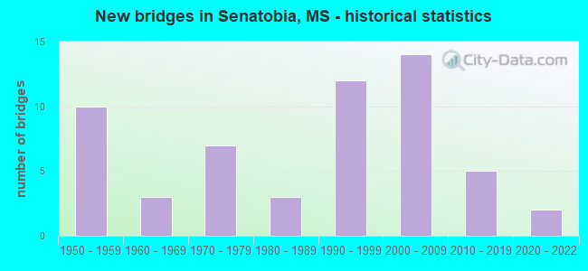
- New bridges - historical statistics
- 101950-1959
- 31960-1969
- 71970-1979
- 31980-1989
- 121990-1999
- 142000-2009
- 52010-2019
- 22020-2022


- Bridge Condition - Deck
- 17.9%Very good
- 35.9%Good
- 30.8%Satisfactory
- 15.4%Fair

- Bridge Condition - Superstructure
- 35.9%Very good
- 23.1%Good
- 30.8%Satisfactory
- 10.3%Fair

- Bridge Condition - Substructure
- 12.8%Very good
- 59.0%Good
- 17.9%Satisfactory
- 5.1%Fair
- 5.1%Poor

- Bridge Condition - Channel
- 20.5%Very good
- 56.8%Good
- 11.4%Satisfactory
- 11.4%Fair

- Bridge Condition - Culverts
- 45.5%Good
- 54.5%Satisfactory
Find on map >> Show street view
Structure Number: SA6900000000113, Location: SEC 12 T 6S R 7W B (Lat: 34.574822, Lng: -89.880464), Route carried "on" structure: County highway 101, Year Built: 1990, Status: Open, Structure Length: 1.25m (4.10ft), Average Daily Traffic: 180 (year 2018), Truck Traffic: 10%, Average Future Daily Traffic: 270 (year 2038), Design Load: HS 20, Features Intersected: GRAVEL SPRINGS CREEK, Facility Carried by Structure: GRAVEL SPRINGS RD
Minimum Vertical Clearance: 30+ m (98+ ft), Kilometerpoint: 4.184, Lanes on structure: 2, Owner: County Highway Agency, Approaching Roadway Width: 7.3m (24.0ft), Material/Design: Prestressed concrete, Design/Construction: Box Beam or Girders - Multiple, Number Of Spans In Main Unit: 1, Length of Maximum Span: 12.5m (41.0ft), Curb-To-Curb Width: 7.3m (24.0ft), Out-to-Out Width: 7.6m (24.9ft)
Condition: Deck: Good, Superstructure: Good, Substructure: Good, Channel: Fair, Operating Rating: 43.2 metric tons, Method Used To Determine Operating Rating: Field evaluation and documented engineering judgment, Inventory Rating: 32.4 metric tons, Method Used To Determine Inventory Rating: Field evaluation and documented engineering judgment, Structural Evaluation: Better than present minimum criteria, Deck Geometry: Somewhat better than minimum adequacy, Waterway Adequacy: Equal to present minimum criteria, Approach Roadway Alignment: Better than present minimum criteria, Length Of Structure Improvement: 2.00m (6.56ft), Designated Inspection Frequency: Every 24 months, Inspection Date: January 2020, Bridge Improvement Cost: $165,000, Roadway Improvement Cost: $42,000, Total Project Cost: $248,000 ( Estimate for 2017), Deck Structure Type: Concrete Precast Panels, Wearing Surface/Protective System: Wearing Surface: Bituminous
Find on map >> Show street view
Structure Number: SA6900000000116, Location: SEC 14 T 6S R 7W B (Lat: 34.561183, Lng: -89.908631), Route carried "on" structure: County highway 104, Year Built: 1990, Status: Open, Structure Length: 4.88m (16.01ft), Average Daily Traffic: 110 (year 2020), Truck Traffic: 4%, Average Future Daily Traffic: 165 (year 2040), Design Load: HS 20, Features Intersected: SENATOBIA CREEK, Facility Carried by Structure: SIDES BOTTOM ROAD
Minimum Vertical Clearance: 30+ m (98+ ft), Kilometerpoint: 0.804, Lanes on structure: 2, Owner: County Highway Agency, Approaching Roadway Width: 7.9m (25.9ft), Material/Design: Prestressed concrete, Design/Construction: Stringer/Multi-beam, Number Of Spans In Main Unit: 3, Length of Maximum Span: 24.4m (80.1ft), Curb or Sidewalk Widths: Left: 0.5m (1.6ft), Right: 0.5m (1.6ft), Curb-To-Curb Width: 8.5m (27.9ft), Out-to-Out Width: 9.5m (31.2ft)
Condition: Deck: Satisfactory, Superstructure: Very good, Substructure: Good, Channel: Good, Operating Rating: 58.3 metric tons, Method Used To Determine Operating Rating: Load Factor (LF) rating reported by rating factor (RF) method using MS18 loading, Inventory Rating: 33.7 metric tons, Method Used To Determine Inventory Rating: Load Factor (LF) rating reported by rating factor (RF) method using MS18 loading, Structural Evaluation: Better than present minimum criteria, Deck Geometry: Equal to present minimum criteria, Waterway Adequacy: Equal to present desirable criteria, Approach Roadway Alignment: Equal to present desirable criteria, Designated Inspection Frequency: Every 24 months, Inspection Date: January 2022, Deck Structure Type: Concrete Cast-file-Place, Wearing Surface/Protective System: Wearing Surface: Monolithic Concrete
Find on map >> Show street view
Structure Number: SA6900000000117, Location: SEC 14 T 6S R 7W B (Lat: 34.561939, Lng: -89.907806), Route carried "on" structure: County highway 104, Year Built: 1990, Status: Open, Structure Length: 7.32m (24.02ft), Average Daily Traffic: 110 (year 2020), Truck Traffic: 4%, Average Future Daily Traffic: 165 (year 2040), Design Load: HS 20, Features Intersected: SENATOBIA CANAL, Facility Carried by Structure: SIDES BOTTOM ROAD
Minimum Vertical Clearance: 30+ m (98+ ft), Kilometerpoint: 0.965, Lanes on structure: 2, Owner: County Highway Agency, Approaching Roadway Width: 7.9m (25.9ft), Material/Design: Prestressed concrete, Design/Construction: Stringer/Multi-beam, Number Of Spans In Main Unit: 5, Length of Maximum Span: 24.4m (80.1ft), Curb or Sidewalk Widths: Left: 0.5m (1.6ft), Right: 0.5m (1.6ft), Curb-To-Curb Width: 8.5m (27.9ft), Out-to-Out Width: 9.5m (31.2ft)
Condition: Deck: Satisfactory, Superstructure: Very good, Substructure: Good, Channel: Good, Operating Rating: 58.3 metric tons, Method Used To Determine Operating Rating: Load Factor (LF) rating reported by rating factor (RF) method using MS18 loading, Inventory Rating: 33.7 metric tons, Method Used To Determine Inventory Rating: Load Factor (LF) rating reported by rating factor (RF) method using MS18 loading, Structural Evaluation: Better than present minimum criteria, Deck Geometry: Equal to present minimum criteria, Waterway Adequacy: Equal to present desirable criteria, Approach Roadway Alignment: Equal to present desirable criteria, Designated Inspection Frequency: Every 24 months, Inspection Date: January 2022, Deck Structure Type: Concrete Cast-file-Place, Wearing Surface/Protective System: Wearing Surface: Monolithic Concrete
Find on map >> Show street view
Structure Number: SA6900000000118, Location: SEC 15 T 6S R 7W B (Lat: 34.568250, Lng: -89.917722), Route carried "on" structure: County highway 91, Year Built: 1992, Status: Posted for load, Structure Length: 2.71m (8.89ft), Average Daily Traffic: 110 (year 2013), Truck Traffic: 5%, Average Future Daily Traffic: 150 (year 2038), Features Intersected: SENATOBIA CREEK BRANCH, Facility Carried by Structure: COUNTRY CLUB ROAD
Minimum Vertical Clearance: 30+ m (98+ ft), Kilometerpoint: 7.885, Lanes on structure: 2, Owner: County Highway Agency, Approaching Roadway Width: 7.3m (24.0ft), Material/Design: Steel, Design/Construction: Box Beam or Girders - Single/Spread, Number Of Spans In Main Unit: 1, Length of Maximum Span: 26.0m (85.3ft), Curb-To-Curb Width: 7.5m (24.6ft), Out-to-Out Width: 8.1m (26.6ft)
Condition: Deck: Satisfactory, Superstructure: Satisfactory, Substructure: Satisfactory, Channel: Good, Operating Rating: 7.8 metric tons, Method Used To Determine Operating Rating: Load Factor (LF), Inventory Rating: 4.9 metric tons, Method Used To Determine Inventory Rating: Load Factor (LF), Structural Evaluation: High priority of replacement, Deck Geometry: Somewhat better than minimum adequacy, Waterway Adequacy: Equal to present minimum criteria, Approach Roadway Alignment: High priority of corrective action, Bridge Posting: Required (Relationship of Operating Rating to Maximum Legal Load: > 39.9% below), Length Of Structure Improvement: 3.78m (12.40ft), Designated Inspection Frequency: Every 12 months, Critical Feature Inspection Frequency: Every 12 months, Inspection Date: December 2021, Critical Feature Inspection Date: December 2021, Bridge Improvement Cost: $333,000, Roadway Improvement Cost: $202,000, Total Project Cost: $599,000 ( Estimate for 2015), Deck Structure Type: Steel plate, Wearing Surface/Protective System: Wearing Surface: Bituminous
Find on map >> Show street view
Structure Number: SA690000000012, Location: SEC 33 T 6S R 7W (Lat: 34.598250, Lng: -89.948583), Route carried "on" structure: City street 91, Year Built: 1993, Status: Posted for load, Structure Length: 2.71m (8.89ft), Average Daily Traffic: 110 (year 2013), Truck Traffic: 8%, Average Future Daily Traffic: 150 (year 2038), Features Intersected: SENATOBIA CREEK BRANCH, Facility Carried by Structure: SHANS BOTTOM ROAD
Minimum Vertical Clearance: 30+ m (98+ ft), Kilometerpoint: 1.770, Lanes on structure: 2, Owner: City or Municipal Highway Agency, Approaching Roadway Width: 7.6m (24.9ft), Skew: 4 degrees, Material/Design: Steel, Design/Construction: Box Beam or Girders - Single/Spread, Number Of Spans In Main Unit: 1, Length of Maximum Span: 22.9m (75.1ft), Curb-To-Curb Width: 7.5m (24.6ft), Out-to-Out Width: 8.1m (26.6ft)
Condition: Deck: Fair, Superstructure: Satisfactory, Substructure: Fair, Channel: Satisfactory, Operating Rating: 4.6 metric tons, Method Used To Determine Operating Rating: Load Factor (LF), Inventory Rating: 2.9 metric tons, Method Used To Determine Inventory Rating: Load Factor (LF), Structural Evaluation: High priority of replacement, Deck Geometry: Somewhat better than minimum adequacy, Waterway Adequacy: Somewhat better than minimum adequacy, Approach Roadway Alignment: Somewhat better than minimum adequacy, Bridge Posting: Required (Relationship of Operating Rating to Maximum Legal Load: > 39.9% below), Length Of Structure Improvement: 3.05m (10.01ft), Designated Inspection Frequency: Every 12 months, Critical Feature Inspection Frequency: Every 12 months, Inspection Date: December 2021, Critical Feature Inspection Date: December 2021, Bridge Improvement Cost: $250,000, Roadway Improvement Cost: $157,000, Total Project Cost: $456,000 ( Estimate for 2015), Deck Structure Type: Steel plate, Wearing Surface/Protective System: Wearing Surface: Bituminous
Find on map >> Show street view
Structure Number: SA6900000000121, Location: SEC 4 T 6S R 8W B (Lat: 34.597858, Lng: -90.054383), Route carried "on" structure: County highway 89, Year Built: 1973, Status: Open, Structure Length: 1.74m (5.71ft), Average Daily Traffic: 150 (year 2020), Truck Traffic: 8%, Average Future Daily Traffic: 225 (year 2040), Design Load: H 15, Features Intersected: ARKABUTLA CREEK BRANCH, Facility Carried by Structure: BROWNS FERRY ROAD
Minimum Vertical Clearance: 30+ m (98+ ft), Kilometerpoint: 8.851, Lanes on structure: 2, Owner: County Highway Agency, Approaching Roadway Width: 7.3m (24.0ft), Material/Design: Concrete, Design/Construction: Channel Beam, Number Of Spans In Main Unit: 3, Length of Maximum Span: 5.8m (19.0ft), Curb or Sidewalk Widths: Left: 0.2m (0.7ft), Right: 0.2m (0.7ft), Curb-To-Curb Width: 7.3m (24.0ft), Out-to-Out Width: 7.7m (25.3ft)
Condition: Deck: Satisfactory, Superstructure: Satisfactory, Substructure: Satisfactory, Channel: Fair, Operating Rating: 22.5 metric tons, Method Used To Determine Operating Rating: Allowable Stress (AS), Inventory Rating: 17.1 metric tons, Method Used To Determine Inventory Rating: Allowable Stress (AS), Structural Evaluation: Somewhat better than minimum adequacy, Deck Geometry: Somewhat better than minimum adequacy, Waterway Adequacy: Better than present minimum criteria, Approach Roadway Alignment: Better than present minimum criteria, Length Of Structure Improvement: 2.47m (8.10ft), Designated Inspection Frequency: Every 24 months, Inspection Date: January 2022, Bridge Improvement Cost: $162,000, Roadway Improvement Cost: $41,000, Total Project Cost: $243,000 ( Estimate for 2017), Deck Structure Type: Concrete Precast Panels, Wearing Surface/Protective System: Wearing Surface: Monolithic Concrete
Find on map >> Show street view
Structure Number: SA6900000000123, Location: SEC 13 T 6S R 8W (Lat: 34.556642, Lng: -90.003875), Route carried "on" structure: County highway 52, Year Built: 2009, Status: Open, Structure Length: 0.67m (2.20ft), Average Daily Traffic: 80 (year 2018), Average Future Daily Traffic: 120 (year 2038), Design Load: HS 20, Features Intersected: ARKABUTLA CREEK, Facility Carried by Structure: HAMMOND HILL ROAD
Minimum Vertical Clearance: 30+ m (98+ ft), Kilometerpoint: 0.321, Lanes on structure: 2, Owner: County Highway Agency, Approaching Roadway Width: 8.5m (27.9ft), Material/Design: Concrete, Design/Construction: Culvert, Number Of Spans In Main Unit: 2, Length of Maximum Span: 3.0m (9.8ft)
Condition: Channel: Good, Culverts: Satisfactory, Operating Rating: 81.3 metric tons, Method Used To Determine Operating Rating: Load Factor (LF) rating reported by rating factor (RF) method using MS18 loading, Inventory Rating: 48.6 metric tons, Method Used To Determine Inventory Rating: Load Factor (LF) rating reported by rating factor (RF) method using MS18 loading, Structural Evaluation: Equal to present minimum criteria, Waterway Adequacy: Equal to present desirable criteria, Approach Roadway Alignment: Better than present minimum criteria, Designated Inspection Frequency: Every 24 months, Inspection Date: January 2021
Find on map >> Show street view
Structure Number: SA6900000000138, Location: SEC 7 T 6S R 7W (Lat: 34.576094, Lng: -89.978011), Route carried "on" structure: City street , Year Built: 2021, Status: Open, Structure Length: 1.21m (3.97ft), Average Daily Traffic: 20 (year 2020), Average Future Daily Traffic: 30 (year 2040), Design Load: HL 93, Features Intersected: PORTER CREEK, Facility Carried by Structure: WATSON ROAD
Minimum Vertical Clearance: 30+ m (98+ ft), Kilometerpoint: 0.803, Lanes on structure: 2, Owner: City or Municipal Highway Agency, Approaching Roadway Width: 4.8m (15.7ft), Skew: 1 degrees, Material/Design: Concrete, Design/Construction: Culvert, Number Of Spans In Main Unit: 2, Length of Maximum Span: 5.5m (18.0ft)
Condition: Channel: Very good, Culverts: Good, Operating Rating: 54.1 metric tons, Method Used To Determine Operating Rating: Load and Resistance Factor Rating (LRFR) rating reported by rating factor(RF) method using HL-93 loadings, Inventory Rating: 32.4 metric tons, Method Used To Determine Inventory Rating: Load and Resistance Factor Rating (LRFR) rating reported by rating factor(RF) method using HL-93 loadings, Structural Evaluation: Better than present minimum criteria, Waterway Adequacy: Better than present minimum criteria, Approach Roadway Alignment: Better than present minimum criteria, Designated Inspection Frequency: Every 24 months, Inspection Date: January 2022
Find on map >> Show street view
Structure Number: SA690000000A119, Location: SEC 18 T 6S R 7W (Lat: 34.563361, Lng: -89.973656), Route carried "on" structure: County highway 88, Year Built: 2021, Status: Open, Structure Length: 1.05m (3.44ft), Average Daily Traffic: 125 (year 2020), Truck Traffic: 4%, Average Future Daily Traffic: 180 (year 2040), Design Load: HL 93, Features Intersected: PORTER CREEK, Facility Carried by Structure: HUGH TAYLOR ROAD
Minimum Vertical Clearance: 30+ m (98+ ft), Kilometerpoint: 7.885, Lanes on structure: 2, Owner: County Highway Agency, Approaching Roadway Width: 8.1m (26.6ft), Material/Design: Concrete, Design/Construction: Culvert, Number Of Spans In Main Unit: 2, Length of Maximum Span: 4.8m (15.7ft)
Condition: Channel: Very good, Culverts: Good, Operating Rating: 54.1 metric tons, Method Used To Determine Operating Rating: Load and Resistance Factor Rating (LRFR) rating reported by rating factor(RF) method using HL-93 loadings, Inventory Rating: 32.4 metric tons, Method Used To Determine Inventory Rating: Load and Resistance Factor Rating (LRFR) rating reported by rating factor(RF) method using HL-93 loadings, Structural Evaluation: Better than present minimum criteria, Waterway Adequacy: Better than present minimum criteria, Approach Roadway Alignment: Better than present minimum criteria, Designated Inspection Frequency: Every 24 months, Inspection Date: January 2022
Find on map >> Show street view
Structure Number: 11000550692655A, Location: I 55 OVER SR 4 (Lat: 34.619219, Lng: -89.951111), Route carried "under" structure: State highway 4, Year Built: 1959, Structure Length: 0. m, Average Daily Traffic: 13,000 (year 2017), Truck Traffic: 16%, Features Intersected: SR 4, Facility Carried by Structure: I 55
Minimum Vertical Clearance: 4.57m (14.99ft), Kilometerpoint: 25.022, Lanes on structure: 2, Lanes under structure: 4, Material/Design: Concrete continuous, Design/Construction: Box Beam or Girders - Single/Spread, Length of Maximum Span: 20.4m (66.9ft)
Find on map >> Show street view
Structure Number: 11000550692655B, Location: I 55 OVER SR 4 (Lat: 34.619169, Lng: -89.950811), Route carried "under" structure: State highway 4, Year Built: 1959, Structure Length: 0. m, Average Daily Traffic: 13,000 (year 2017), Truck Traffic: 16%, Features Intersected: SR 4, Facility Carried by Structure: I 55
Minimum Vertical Clearance: 4.55m (14.93ft), Kilometerpoint: 25.051, Lanes on structure: 2, Lanes under structure: 3, Material/Design: Concrete continuous, Design/Construction: Box Beam or Girders - Single/Spread, Length of Maximum Span: 20.4m (66.9ft)
Find on map >> Show street view
Structure Number: 31007400690405A, Location: SR 740 OVER I 55 (Lat: 34.588181, Lng: -89.946969), Route carried "under" structure: Interstate 55, Year Built: 2006, Structure Length: 0. m, Average Daily Traffic: 12,500 (year 2017), Truck Traffic: 15%, Features Intersected: I 55, Facility Carried by Structure: SR 740
Minimum Vertical Clearance: 5.51m (18.08ft), Kilometerpoint: 3.970, Lanes on structure: 2, Lanes under structure: 4, Material/Design: Prestressed concrete continuous, Design/Construction: Stringer/Multi-beam, Length of Maximum Span: 29.9m (98.1ft)
Find on map >> Show street view
Structure Number: 31007400690405A, Location: SR 740 OVER I 55 (Lat: 34.588169, Lng: -89.947261), Route carried "under" structure: Interstate 55, Year Built: 2006, Structure Length: 0. m, Average Daily Traffic: 12,500 (year 2017), Truck Traffic: 15%, Features Intersected: I 55, Facility Carried by Structure: SR 740
Minimum Vertical Clearance: 5.51m (18.08ft), Kilometerpoint: 15.622, Lanes on structure: 2, Lanes under structure: 4, Material/Design: Prestressed concrete continuous, Design/Construction: Stringer/Multi-beam, Length of Maximum Span: 29.9m (98.1ft)
Find on map >> Show street view
Structure Number: 31007400690405B, Location: SR 740 OVER I 55 (Lat: 34.587819, Lng: -89.947250), Route carried "under" structure: Interstate 55, Year Built: 2006, Structure Length: 0. m, Average Daily Traffic: 12,500 (year 2017), Truck Traffic: 15%, Features Intersected: I 55, Facility Carried by Structure: SR 740
Minimum Vertical Clearance: 5.08m (16.67ft), Kilometerpoint: 15.661, Lanes on structure: 2, Lanes under structure: 4, Material/Design: Prestressed concrete continuous, Design/Construction: Stringer/Multi-beam, Length of Maximum Span: 29.9m (98.1ft)
Find on map >> Show street view
Structure Number: 31007400690405B, Location: SR 740 OVER I 55 (Lat: 34.587819, Lng: -89.946961), Route carried "under" structure: Interstate 55, Year Built: 2006, Structure Length: 0. m, Average Daily Traffic: 12,500 (year 2017), Truck Traffic: 15%, Features Intersected: I 55, Facility Carried by Structure: SR 740
Minimum Vertical Clearance: 5.11m (16.77ft), Kilometerpoint: 3.930, Lanes on structure: 2, Lanes under structure: 4, Material/Design: Prestressed concrete continuous, Design/Construction: Stringer/Multi-beam, Length of Maximum Span: 29.9m (98.1ft)