Bridge Statistics for Sherman, Texas (TX)
Condition, Traffic, Stress, Structural Evaluation, Project Costs
- National Bridge Inventory (NBI) Statistics
- 174Number of bridges
- 1,969ft / 600mTotal length
- $1,135,000Total costs
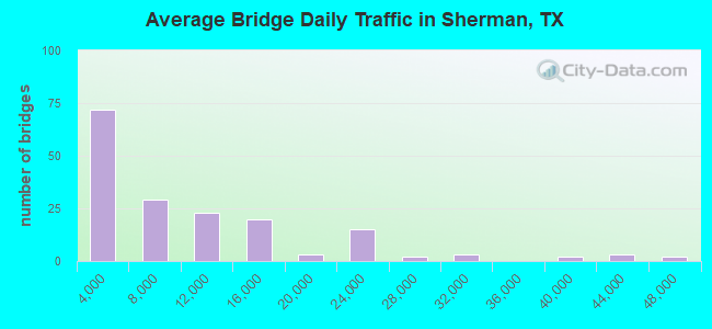
- 1,569,675Total average daily traffic
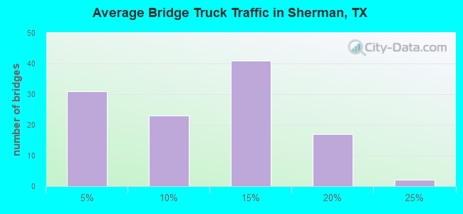
- 143,682Total average daily truck traffic
- National Bridge Inventory (NBI) Registered Bridges for Sherman
- No street view available for this location
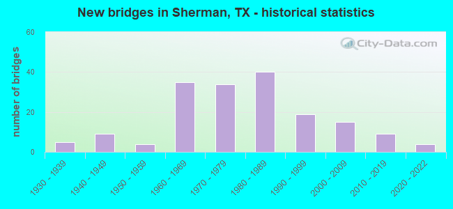
- New bridges - historical statistics
- 51930-1939
- 91940-1949
- 41950-1959
- 351960-1969
- 341970-1979
- 401980-1989
- 191990-1999
- 152000-2009
- 92010-2019
- 42020-2022

- Reconstructed bridges - Historical Statistics
- 31950-1959
- 01960-1969
- 21970-1979
- 11980-1989
- 31990-1999
- 12000-2009
- 12010-2019
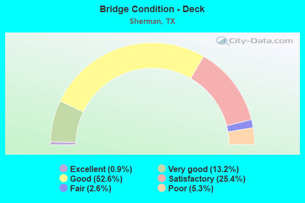
- Bridge Condition - Deck
- 0.9%Excellent
- 13.2%Very good
- 52.6%Good
- 25.4%Satisfactory
- 2.6%Fair
- 5.3%Poor
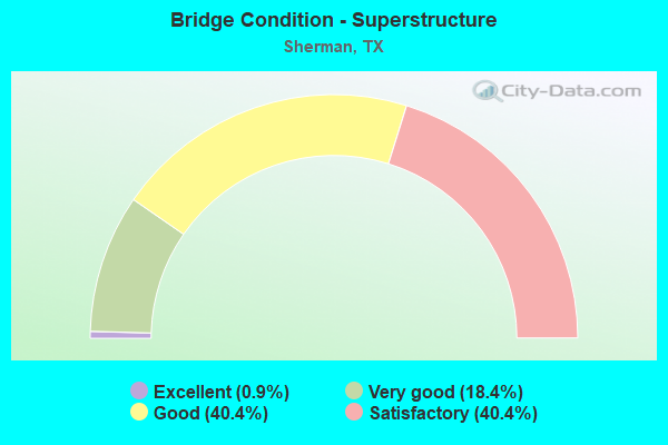
- Bridge Condition - Superstructure
- 0.9%Excellent
- 18.4%Very good
- 40.4%Good
- 40.4%Satisfactory
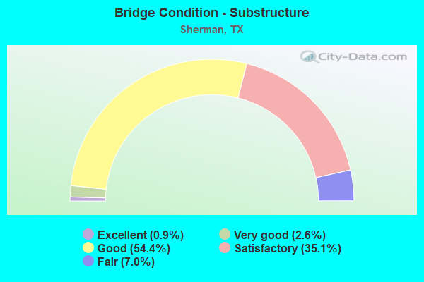
- Bridge Condition - Substructure
- 0.9%Excellent
- 2.6%Very good
- 54.4%Good
- 35.1%Satisfactory
- 7.0%Fair
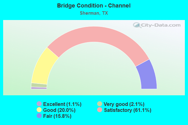
- Bridge Condition - Channel
- 1.1%Excellent
- 2.1%Very good
- 20.0%Good
- 61.1%Satisfactory
- 15.8%Fair
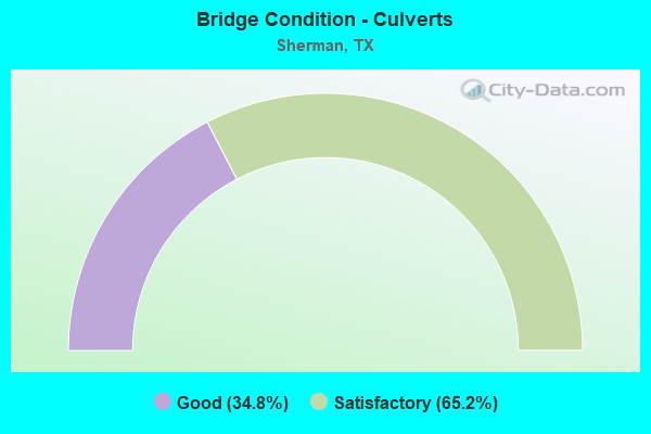
- Bridge Condition - Culverts
- 34.8%Good
- 65.2%Satisfactory
Find on map >> Show street view
Structure Number: 10920C01430001, Location: 0.05 MI W OF RICKETT ST (Lat: 33.638817, Lng: -96.621703), Route carried "on" structure: City street , Year Built: 1970, Status: Open, Structure Length: 1.59m (5.22ft), Average Daily Traffic: 2,830 (year 2010), Average Future Daily Traffic: 3,225 (year 2030), Features Intersected: POST OAK CREEK, Facility Carried by Structure: HILLCREST ST
Minimum Vertical Clearance: 30+ m (98+ ft), Kilometerpoint: 0.097, Lanes on structure: 2, Owner: City or Municipal Highway Agency, Approaching Roadway Width: 8.8m (28.9ft), Material/Design: Steel, Design/Construction: Stringer/Multi-beam, Number Of Spans In Main Unit: 1, Length of Maximum Span: 15.2m (49.9ft), Curb or Sidewalk Widths: Left: 0.5m (1.6ft), Right: 1.3m (4.3ft), Curb-To-Curb Width: 9.0m (29.5ft), Out-to-Out Width: 10.7m (35.1ft)
Condition: Deck: Satisfactory, Superstructure: Good, Substructure: Satisfactory, Channel: Satisfactory, Operating Rating: 44.4 metric tons, Method Used To Determine Operating Rating: Allowable Stress (AS), Inventory Rating: 32.7 metric tons, Method Used To Determine Inventory Rating: Allowable Stress (AS), Structural Evaluation: Equal to present minimum criteria, Deck Geometry: Meets minimum limits, Waterway Adequacy: Better than present minimum criteria, Approach Roadway Alignment: Equal to present desirable criteria, Designated Inspection Frequency: Every 24 months, Inspection Date: March 2020, Deck Structure Type: Concrete Cast-file-Place
Find on map >> Show street view
Structure Number: 10920C01810001, Location: 0.45 MI E OF FM 1417 (Lat: 33.658042, Lng: -96.636706), Route carried "on" structure: City street , Year Built: 1962, Status: Open, Structure Length: 3.72m (12.20ft), Average Daily Traffic: 4,020 (year 2010), Average Future Daily Traffic: 365 (year 2030), Features Intersected: POST OAK CREEK, Facility Carried by Structure: LAMBERTH RD
Minimum Vertical Clearance: 30+ m (98+ ft), Kilometerpoint: 0.692, Lanes on structure: 2, Owner: City or Municipal Highway Agency, Approaching Roadway Width: 11.0m (36.1ft), Material/Design: Concrete, Design/Construction: Stringer/Multi-beam, Number Of Spans In Main Unit: 3, Length of Maximum Span: 12.2m (40.0ft), Curb or Sidewalk Widths: Left: 1.8m (5.9ft), Right: 1.8m (5.9ft), Curb-To-Curb Width: 11.0m (36.1ft), Out-to-Out Width: 15.4m (50.5ft)
Condition: Deck: Fair, Superstructure: Satisfactory, Substructure: Good, Channel: Fair, Operating Rating: 32.7 metric tons, Method Used To Determine Operating Rating: Field evaluation and documented engineering judgment, Inventory Rating: 24.5 metric tons, Method Used To Determine Inventory Rating: Field evaluation and documented engineering judgment, Structural Evaluation: Equal to present minimum criteria, Deck Geometry: Somewhat better than minimum adequacy, Waterway Adequacy: Better than present minimum criteria, Approach Roadway Alignment: Equal to present desirable criteria, Length Of Structure Improvement: 3.66m (12.01ft), Designated Inspection Frequency: Every 24 months, Inspection Date: Febuary 2020, Deck Structure Type: Concrete Cast-file-Place
Find on map >> Show street view
Structure Number: 10920C02260001, Location: 0.55 MI E OF GRANT ST (Lat: 33.647394, Lng: -96.629300), Route carried "on" structure: City street , Year Built: 1959, Status: Open, Structure Length: 2.74m (8.99ft), Average Daily Traffic: 3,020 (year 2010), Average Future Daily Traffic: 2,330 (year 2030), Features Intersected: POST OAK CREEK, Facility Carried by Structure: WEST MCGEE ST
Minimum Vertical Clearance: 30+ m (98+ ft), Kilometerpoint: 0.885, Lanes on structure: 2, Owner: City or Municipal Highway Agency, Approaching Roadway Width: 11.0m (36.1ft), Material/Design: Concrete continuous, Design/Construction: Slab, Number Of Spans In Main Unit: 3, Length of Maximum Span: 9.1m (29.9ft), Curb or Sidewalk Widths: Left: 0.5m (1.6ft), Right: 0.5m (1.6ft), Curb-To-Curb Width: 11.0m (36.1ft), Out-to-Out Width: 12.2m (40.0ft)
Condition: Deck: Satisfactory, Superstructure: Good, Substructure: Satisfactory, Channel: Fair, Operating Rating: 32.7 metric tons, Method Used To Determine Operating Rating: Field evaluation and documented engineering judgment, Inventory Rating: 24.5 metric tons, Method Used To Determine Inventory Rating: Field evaluation and documented engineering judgment, Structural Evaluation: Equal to present minimum criteria, Deck Geometry: Somewhat better than minimum adequacy, Waterway Adequacy: Better than present minimum criteria, Approach Roadway Alignment: Equal to present desirable criteria, Length Of Structure Improvement: 2.77m (9.09ft), Designated Inspection Frequency: Every 24 months, Inspection Date: Febuary 2020, Total Project Cost: $51,000, Deck Structure Type: Concrete Cast-file-Place
Find on map >> Show street view
Structure Number: 10920C02620001, Location: 0.05 MI E OF N RICKETTS (Lat: 33.636783, Lng: -96.619367), Route carried "on" structure: City street , Year Built: 1949, Status: Open, Structure Length: 2.53m (8.30ft), Average Daily Traffic: 390 (year 2010), Average Future Daily Traffic: 425 (year 2030), Features Intersected: POST OAK CREEK, Facility Carried by Structure: W PECAN ST
Minimum Vertical Clearance: 30+ m (98+ ft), Kilometerpoint: 1.287, Lanes on structure: 2, Owner: City or Municipal Highway Agency, Approaching Roadway Width: 8.5m (27.9ft), Skew: 3 degrees, Material/Design: Steel continuous, Design/Construction: Stringer/Multi-beam, Number Of Spans In Main Unit: 2, Length of Maximum Span: 12.5m (41.0ft), Curb or Sidewalk Widths: Left: 0.5m (1.6ft), Right: 1.3m (4.3ft), Curb-To-Curb Width: 9.1m (29.9ft), Out-to-Out Width: 10.8m (35.4ft)
Condition: Deck: Satisfactory, Superstructure: Good, Substructure: Good, Channel: Fair, Operating Rating: 44.4 metric tons, Method Used To Determine Operating Rating: Allowable Stress (AS), Inventory Rating: 32.7 metric tons, Method Used To Determine Inventory Rating: Allowable Stress (AS), Structural Evaluation: Better than present minimum criteria, Deck Geometry: Equal to present minimum criteria, Waterway Adequacy: Better than present minimum criteria, Approach Roadway Alignment: Equal to present desirable criteria, Designated Inspection Frequency: Every 24 months, Inspection Date: March 2020, Deck Structure Type: Concrete Cast-file-Place
Find on map >> Show street view
Structure Number: 10920C02760001, Location: 0.25 MI N OF SH 56 (Lat: 33.638192, Lng: -96.620436), Route carried "on" structure: City street , Year Built: 1960, Status: Open, Structure Length: 1.43m (4.69ft), Average Daily Traffic: 1,570 (year 2010), Average Future Daily Traffic: 2,197 (year 2030), Features Intersected: POST OAK CREEK, Facility Carried by Structure: N RICKETTS ST
Minimum Vertical Clearance: 30+ m (98+ ft), Kilometerpoint: 3.219, Lanes on structure: 2, Owner: City or Municipal Highway Agency, Approaching Roadway Width: 7.3m (24.0ft), Skew: 1 degrees, Material/Design: Steel, Design/Construction: Stringer/Multi-beam, Number Of Spans In Main Unit: 1, Length of Maximum Span: 14.0m (45.9ft), Curb or Sidewalk Widths: Left: 0.5m (1.6ft), Right: 1.0m (3.3ft), Curb-To-Curb Width: 7.9m (25.9ft), Out-to-Out Width: 9.3m (30.5ft)
Condition: Deck: Satisfactory, Superstructure: Good, Substructure: Good, Channel: Satisfactory, Operating Rating: 44.4 metric tons, Method Used To Determine Operating Rating: Allowable Stress (AS), Inventory Rating: 30.8 metric tons, Method Used To Determine Inventory Rating: Allowable Stress (AS), Structural Evaluation: Better than present minimum criteria, Deck Geometry: Meets minimum limits, Waterway Adequacy: Better than present minimum criteria, Approach Roadway Alignment: Equal to present desirable criteria, Designated Inspection Frequency: Every 24 months, Inspection Date: March 2020, Deck Structure Type: Concrete Cast-file-Place
Find on map >> Show street view
Structure Number: 10920C04180001, Location: 0.35 MI E OF GRANT ST (Lat: 33.651892, Lng: -96.632903), Route carried "on" structure: City street , Year Built: 1964, Status: Open, Structure Length: 2.74m (8.99ft), Average Daily Traffic: 4,340 (year 2010), Average Future Daily Traffic: 7,250 (year 2030), Features Intersected: POST OAK CREEK, Facility Carried by Structure: TAYLOR ST
Minimum Vertical Clearance: 30+ m (98+ ft), Kilometerpoint: 0.966, Lanes on structure: 2, Owner: City or Municipal Highway Agency, Approaching Roadway Width: 11.0m (36.1ft), Material/Design: Concrete continuous, Design/Construction: Slab, Number Of Spans In Main Unit: 3, Length of Maximum Span: 9.1m (29.9ft), Curb or Sidewalk Widths: Left: 1.2m (3.9ft), Right: 0.6m (2.0ft), Curb-To-Curb Width: 11.0m (36.1ft), Out-to-Out Width: 12.8m (42.0ft)
Condition: Deck: Fair, Superstructure: Satisfactory, Substructure: Good, Channel: Satisfactory, Operating Rating: 32.7 metric tons, Method Used To Determine Operating Rating: Field evaluation and documented engineering judgment, Inventory Rating: 24.5 metric tons, Method Used To Determine Inventory Rating: Field evaluation and documented engineering judgment, Structural Evaluation: Equal to present minimum criteria, Deck Geometry: Somewhat better than minimum adequacy, Waterway Adequacy: Better than present minimum criteria, Approach Roadway Alignment: Equal to present desirable criteria, Length Of Structure Improvement: 2.77m (9.09ft), Designated Inspection Frequency: Every 24 months, Inspection Date: Febuary 2020, Total Project Cost: $51,000, Deck Structure Type: Concrete Cast-file-Place
Find on map >> Show street view
Structure Number: 10920C04321001, Location: 1.0 MI N OF FM 1417 (Lat: 33.608942, Lng: -96.605033), Route carried "on" structure: City street , Year Built: 1940, Status: Open, Structure Length: 7.04m (23.10ft), Average Daily Traffic: 3,390 (year 2010), Average Future Daily Traffic: 90 (year 2030), Features Intersected: POST OAK CREEK, Facility Carried by Structure: S TRAVIS BLVD
Minimum Vertical Clearance: 30+ m (98+ ft), Kilometerpoint: 0.563, Lanes on structure: 2, Owner: City or Municipal Highway Agency, Approaching Roadway Width: 8.5m (27.9ft), Material/Design: Concrete, Design/Construction: Tee Beam, Number Of Spans In Main Unit: 7, Length of Maximum Span: 10.1m (33.1ft), Curb-To-Curb Width: 8.5m (27.9ft), Out-to-Out Width: 8.5m (27.9ft)
Condition: Deck: Satisfactory, Superstructure: Satisfactory, Substructure: Satisfactory, Channel: Satisfactory, Operating Rating: 32.7 metric tons, Method Used To Determine Operating Rating: Field evaluation and documented engineering judgment, Inventory Rating: 24.5 metric tons, Method Used To Determine Inventory Rating: Field evaluation and documented engineering judgment, Structural Evaluation: Equal to present minimum criteria, Deck Geometry: Meets minimum limits, Waterway Adequacy: Better than present minimum criteria, Approach Roadway Alignment: Equal to present desirable criteria, Length Of Structure Improvement: 7.04m (23.10ft), Designated Inspection Frequency: Every 24 months, Inspection Date: March 2020, Bridge Improvement Cost: $12,000, Roadway Improvement Cost: $3,000, Total Project Cost: $15,000, Deck Structure Type: Concrete Cast-file-Place, Wearing Surface/Protective System: Wearing Surface: Bituminous
Find on map >> Show street view
Structure Number: 10920C04490001, Location: 0.50 MI W OF US 75 (Lat: 33.642067, Lng: -96.624914), Route carried "on" structure: City street , Year Built: 1949, Status: Open, Structure Length: 1.59m (5.22ft), Average Daily Traffic: 5,310 (year 2010), Average Future Daily Traffic: 6,550 (year 2030), Features Intersected: POST OAK CREEK, Facility Carried by Structure: W WASHINGTON ST
Minimum Vertical Clearance: 30+ m (98+ ft), Kilometerpoint: 2.897, Lanes on structure: 2, Owner: City or Municipal Highway Agency, Approaching Roadway Width: 7.9m (25.9ft), Material/Design: Steel, Design/Construction: Stringer/Multi-beam, Number Of Spans In Main Unit: 1, Length of Maximum Span: 15.2m (49.9ft), Curb or Sidewalk Widths: Left: 0.0m, Right: 1.3m (4.3ft), Curb-To-Curb Width: 9.1m (29.9ft), Out-to-Out Width: 10.9m (35.8ft)
Condition: Deck: Satisfactory, Superstructure: Good, Substructure: Good, Channel: Satisfactory, Operating Rating: 44.4 metric tons, Method Used To Determine Operating Rating: Allowable Stress (AS), Inventory Rating: 28.1 metric tons, Method Used To Determine Inventory Rating: Allowable Stress (AS), Structural Evaluation: Better than present minimum criteria, Deck Geometry: High priority of corrective action, Waterway Adequacy: Better than present minimum criteria, Approach Roadway Alignment: Equal to present desirable criteria, Length Of Structure Improvement: 1.59m (5.22ft), Designated Inspection Frequency: Every 24 months, Inspection Date: Febuary 2020, Bridge Improvement Cost: $3,000, Roadway Improvement Cost: $1,000, Total Project Cost: $4,000, Deck Structure Type: Concrete Cast-file-Place
Find on map >> Show street view
Structure Number: 10920C04610001, Location: 0.10 MI N OF SH 56 WB (Lat: 33.636047, Lng: -96.618086), Route carried "on" structure: City street , Year Built: 1984, Status: Open, Structure Length: 2.77m (9.09ft), Average Daily Traffic: 1,080 (year 2010), Average Future Daily Traffic: 1,390 (year 2030), Features Intersected: POST OAK CREEK, Facility Carried by Structure: N WOODS ST
Minimum Vertical Clearance: 30+ m (98+ ft), Kilometerpoint: 2.897, Lanes on structure: 2, Owner: City or Municipal Highway Agency, Approaching Roadway Width: 5.5m (18.0ft), Material/Design: Concrete, Design/Construction: Stringer/Multi-beam, Number Of Spans In Main Unit: 3, Length of Maximum Span: 9.1m (29.9ft), Curb or Sidewalk Widths: Left: 0.0m, Right: 1.8m (5.9ft), Curb-To-Curb Width: 6.8m (22.3ft), Out-to-Out Width: 9.2m (30.2ft)
Condition: Deck: Good, Superstructure: Good, Substructure: Very good, Channel: Satisfactory, Operating Rating: 32.7 metric tons, Method Used To Determine Operating Rating: Field evaluation and documented engineering judgment, Inventory Rating: 24.5 metric tons, Method Used To Determine Inventory Rating: Field evaluation and documented engineering judgment, Structural Evaluation: Equal to present minimum criteria, Deck Geometry: High priority of corrective action, Waterway Adequacy: Better than present minimum criteria, Approach Roadway Alignment: Equal to present desirable criteria, Length Of Structure Improvement: 2.80m (9.19ft), Designated Inspection Frequency: Every 24 months, Inspection Date: March 2020, Bridge Improvement Cost: $4,000, Roadway Improvement Cost: $1,000, Total Project Cost: $5,000, Deck Structure Type: Concrete Cast-file-Place
Structure Number: 10920004503247, Location: 1.8 MI. W OF US 75, Route carried "under" structure: State highway 56, Year Built: 2009, Structure Length: 0. m, Average Daily Traffic: 5,030 (year 2013), Truck Traffic: 12%, Features Intersected: SH 56, Facility Carried by Structure: FM 1417
Minimum Vertical Clearance: 5.56m (18.24ft), Kilometerpoint: 28.500, Material/Design: Prestressed concrete, Design/Construction: Stringer/Multi-beam, Length of Maximum Span: 38.1m (125.0ft)
Minimum Vertical Clearance: 5.56m (18.24ft), Kilometerpoint: 28.500, Material/Design: Prestressed concrete, Design/Construction: Stringer/Multi-beam, Length of Maximum Span: 38.1m (125.0ft)
Structure Number: 10920004518139, Location: 1.85 MI W OF US 75, Route carried "under" structure: State highway 1417, Year Built: 1971, Structure Length: 0. m, Average Daily Traffic: 7,460 (year 2010), Truck Traffic: 5%, Features Intersected: FM 1417, Facility Carried by Structure: US 82 WB
Minimum Vertical Clearance: 4.62m (15.16ft), Kilometerpoint: 4.339, Material/Design: Prestressed concrete, Design/Construction: Stringer/Multi-beam, Length of Maximum Span: 28.0m (91.9ft)
Minimum Vertical Clearance: 4.62m (15.16ft), Kilometerpoint: 4.339, Material/Design: Prestressed concrete, Design/Construction: Stringer/Multi-beam, Length of Maximum Span: 28.0m (91.9ft)
Structure Number: 1092000451814, Location: 1.85 MI W OF US 75, Route carried "under" structure: State highway 1417, Year Built: 1971, Structure Length: 0. m, Average Daily Traffic: 12,370 (year 2010), Truck Traffic: 5%, Features Intersected: FM 1417, Facility Carried by Structure: US 82 EB
Minimum Vertical Clearance: 4.78m (15.68ft), Kilometerpoint: 4.360, Material/Design: Prestressed concrete, Design/Construction: Stringer/Multi-beam, Length of Maximum Span: 28.0m (91.9ft)
Minimum Vertical Clearance: 4.78m (15.68ft), Kilometerpoint: 4.360, Material/Design: Prestressed concrete, Design/Construction: Stringer/Multi-beam, Length of Maximum Span: 28.0m (91.9ft)
Structure Number: 10920004518249, Location: INT OF SH 289 & US 82, Route carried "under" structure: US 82, Year Built: 2010, Structure Length: 0. m, Average Daily Traffic: 14,300 (year 2009), Truck Traffic: 3%, Features Intersected: US 82, Facility Carried by Structure: SH 289
Minimum Vertical Clearance: 5.41m (17.75ft), Kilometerpoint: 23.278, Material/Design: Prestressed concrete, Design/Construction: Stringer/Multi-beam, Length of Maximum Span: 24.4m (80.1ft)
Minimum Vertical Clearance: 5.41m (17.75ft), Kilometerpoint: 23.278, Material/Design: Prestressed concrete, Design/Construction: Stringer/Multi-beam, Length of Maximum Span: 24.4m (80.1ft)
Find on map >> Show street view
Structure Number: 10920004519037, Location: 0.45 MI W OF US 75 (Lat: 33.670731, Lng: -96.617542), Route carried "under" structure: US 82, Year Built: 1975, Structure Length: 0. m, Average Daily Traffic: 23,500 (year 2013), Truck Traffic: 2%, Features Intersected: US 82, Facility Carried by Structure: FM 131
Minimum Vertical Clearance: 5.36m (17.59ft), Kilometerpoint: 30.814, Lanes on structure: 2, Lanes under structure: 4, Material/Design: Prestressed concrete, Design/Construction: Stringer/Multi-beam, Length of Maximum Span: 24.4m (80.1ft)
Find on map >> Show street view
Structure Number: 10920004519144, Location: 0.2 MI W OF SH 91 (Lat: 33.667844, Lng: -96.598342), Route carried "under" structure: ServiceUS 82, Year Built: 1975, Structure Length: 0. m, Average Daily Traffic: 1,120 (year 2009), Truck Traffic: 6%, Features Intersected: FRTG RD TURNAROUND
Minimum Vertical Clearance: 6.86m (22.51ft), Kilometerpoint: 32.602, Lanes on structure: 3, Lanes under structure: 2, Material/Design: Prestressed concrete, Design/Construction: Stringer/Multi-beam, Length of Maximum Span: 18.3m (60.0ft)
Find on map >> Show street view
Structure Number: 10920004519145, Location: 0.2 MI W OF SH 91 (Lat: 33.667842, Lng: -96.598406), Route carried "under" structure: ServiceUS 82, Year Built: 1975, Structure Length: 0. m, Average Daily Traffic: 1,120 (year 2009), Truck Traffic: 2%, Features Intersected: FRTG RD TURNAROUND
Minimum Vertical Clearance: 6.10m (20.01ft), Kilometerpoint: 32.602, Lanes on structure: 3, Lanes under structure: 2, Material/Design: Prestressed concrete, Design/Construction: Stringer/Multi-beam, Length of Maximum Span: 18.3m (60.0ft)
Structure Number: 10920004519148, Location: 0.3 MI E OF SH 91, Route carried "under" structure: City street , Year Built: 1975, Structure Length: 0. m, Average Daily Traffic: 7,140 (year 2009), Features Intersected: SP RR & FRISCO RD, Facility Carried by Structure: US 82 EB
Minimum Vertical Clearance: 6.96m (22.83ft), Kilometerpoint: 2.726, Material/Design: Prestressed concrete, Design/Construction: Stringer/Multi-beam, Length of Maximum Span: 21.3m (69.9ft)
Minimum Vertical Clearance: 6.96m (22.83ft), Kilometerpoint: 2.726, Material/Design: Prestressed concrete, Design/Construction: Stringer/Multi-beam, Length of Maximum Span: 21.3m (69.9ft)
Find on map >> Show street view
Structure Number: 10920004519149, Location: 0.3 MI E OF SH 91 (Lat: 33.666508, Lng: -96.591033), Route carried "under" structure: City street , Year Built: 1975, Structure Length: 0. m, Average Daily Traffic: 7,140 (year 2009), Features Intersected: SP RR & FRISCO RD, Facility Carried by Structure: US 82 WB
Minimum Vertical Clearance: 6.96m (22.83ft), Kilometerpoint: 2.726, Lanes on structure: 3, Lanes under structure: 4, Material/Design: Prestressed concrete, Design/Construction: Stringer/Multi-beam, Length of Maximum Span: 21.3m (69.9ft)
Find on map >> Show street view
Structure Number: 10920004519152, Location: 0.20 MI E OF US 75 (Lat: 33.669628, Lng: -96.606214), Route carried "under" structure: US 82, Year Built: 1975, Structure Length: 0. m, Average Daily Traffic: 15,330 (year 2013), Truck Traffic: 2%, Features Intersected: US 82, Facility Carried by Structure: LOY LAKE ROAD
Minimum Vertical Clearance: 5.08m (16.67ft), Kilometerpoint: 31.884, Lanes on structure: 3, Lanes under structure: 4, Material/Design: Prestressed concrete, Design/Construction: Stringer/Multi-beam, Length of Maximum Span: 21.3m (69.9ft)
Find on map >> Show street view
Structure Number: 10920004519225, Location: 0.90 MI E OF US 75 (Lat: 33.667156, Lng: -96.595242), Route carried "under" structure: State highway 91, Year Built: 1975, Structure Length: 0. m, Average Daily Traffic: 17,300 (year 2010), Truck Traffic: 23%, Features Intersected: SH 91, Facility Carried by Structure: US 82 EB
Minimum Vertical Clearance: 4.75m (15.58ft), Kilometerpoint: 19.397, Lanes on structure: 2, Lanes under structure: 5, Material/Design: Prestressed concrete, Design/Construction: Stringer/Multi-beam, Length of Maximum Span: 24.4m (80.1ft)
Find on map >> Show street view
Structure Number: 10920004519226, Location: 0.90 MI E OF US 75 (Lat: 33.667311, Lng: -96.595136), Route carried "under" structure: State highway 91, Year Built: 1975, Structure Length: 0. m, Average Daily Traffic: 17,300 (year 2010), Truck Traffic: 23%, Features Intersected: SH 91, Facility Carried by Structure: US 82 WB
Minimum Vertical Clearance: 4.93m (16.17ft), Kilometerpoint: 19.397, Lanes on structure: 2, Lanes under structure: 5, Material/Design: Prestressed concrete, Design/Construction: Stringer/Multi-beam, Length of Maximum Span: 24.4m (80.1ft)
Structure Number: 10920004519254, Location: 1.3 MI N OF SH 56, Route carried "under" structure: US 82, Year Built: 2011, Structure Length: 0. m, Average Daily Traffic: 13,150 (year 2013), Truck Traffic: 2%, Features Intersected: US 82, Facility Carried by Structure: FM 1417
Minimum Vertical Clearance: 5.39m (17.68ft), Kilometerpoint: 33.227, Material/Design: Prestressed concrete, Design/Construction: Stringer/Multi-beam, Length of Maximum Span: 38.1m (125.0ft)
Minimum Vertical Clearance: 5.39m (17.68ft), Kilometerpoint: 33.227, Material/Design: Prestressed concrete, Design/Construction: Stringer/Multi-beam, Length of Maximum Span: 38.1m (125.0ft)
Find on map >> Show street view
Structure Number: 10920004702141, Location: 1.7 MI S OF US 82 (Lat: 33.646897, Lng: -96.612731), Route carried "under" structure: State highway 131, Year Built: 1962, Structure Length: 0. m, Average Daily Traffic: 6,960 (year 2013), Truck Traffic: 15%, Features Intersected: FM 131, Facility Carried by Structure: US 75
Minimum Vertical Clearance: 4.93m (16.17ft), Kilometerpoint: 38.412, Lanes on structure: 7, Lanes under structure: 6, Material/Design: Steel continuous, Design/Construction: Stringer/Multi-beam, Length of Maximum Span: 22.9m (75.1ft)
Find on map >> Show street view
Structure Number: 10920004702215, Location: 2.65 MI S OF US 82 (Lat: 33.634203, Lng: -96.615906), Route carried "under" structure: State highway 56, Year Built: 1961, Structure Length: 0. m, Average Daily Traffic: 13,040 (year 2013), Truck Traffic: 6%, Features Intersected: LAMAR ST (SH 56 EB), Facility Carried by Structure: US 75 NB
Minimum Vertical Clearance: 4.98m (16.34ft), Kilometerpoint: 31.455, Lanes on structure: 2, Lanes under structure: 3, Material/Design: Steel continuous, Design/Construction: Stringer/Multi-beam, Length of Maximum Span: 18.3m (60.0ft)
Find on map >> Show street view
Structure Number: 10920004702216, Location: 2.65 MI S OF US 82 (Lat: 33.634172, Lng: -96.616122), Route carried "under" structure: State highway 56, Year Built: 1961, Structure Length: 0. m, Average Daily Traffic: 9,130 (year 2013), Truck Traffic: 6%, Features Intersected: LAMAR ST (SH 56 EB), Facility Carried by Structure: US 75 SB
Minimum Vertical Clearance: 5.72m (18.77ft), Kilometerpoint: 31.426, Lanes on structure: 2, Lanes under structure: 3, Material/Design: Steel continuous, Design/Construction: Stringer/Multi-beam, Length of Maximum Span: 18.3m (60.0ft)
Find on map >> Show street view
Structure Number: 10920004702217, Location: 2.60 MI S OF US 82 (Lat: 33.635136, Lng: -96.616397), Route carried "under" structure: State highway 56, Year Built: 1961, Structure Length: 0. m, Average Daily Traffic: 9,130 (year 2013), Truck Traffic: 6%, Features Intersected: HOUSTON ST (SH 56 WB), Facility Carried by Structure: US 75 NB
Minimum Vertical Clearance: 5.01m (16.44ft), Kilometerpoint: 31.319, Lanes on structure: 2, Lanes under structure: 4, Material/Design: Steel continuous, Design/Construction: Stringer/Multi-beam, Length of Maximum Span: 18.3m (60.0ft)
Find on map >> Show street view
Structure Number: 10920004702218, Location: 2.60 MI S OF US 82 (Lat: 33.635175, Lng: -96.616181), Route carried "under" structure: State highway 56, Year Built: 1961, Structure Length: 0. m, Average Daily Traffic: 9,130 (year 2013), Truck Traffic: 6%, Features Intersected: HOUSTON ST (SH 56 WB), Facility Carried by Structure: US 75 SB
Minimum Vertical Clearance: 5.49m (18.01ft), Kilometerpoint: 31.339, Lanes on structure: 2, Lanes under structure: 4, Material/Design: Steel continuous, Design/Construction: Stringer/Multi-beam, Length of Maximum Span: 18.3m (60.0ft)
Find on map >> Show street view
Structure Number: 10920004702679, Location: 0.5 MI North of CR 1417 (Lat: 33.601814, Lng: -96.608628), Route carried "under" structure: US 75, Year Built: 2021, Structure Length: 0. m, Average Daily Traffic: 1,250 (year 2020), Truck Traffic: 5%, Features Intersected: US 75
Minimum Vertical Clearance: 5.79m (19.00ft), Kilometerpoint: 0.000, Lanes on structure: 1, Lanes under structure: 4, Material/Design: Prestressed concrete, Design/Construction: Stringer/Multi-beam, Length of Maximum Span: 32.0m (105.0ft)
Structure Number: 10920004703127, Location: 1.4 MI S OF SH 56, Route carried "under" structure: City street , Year Built: 1961, Structure Length: 0. m, Average Daily Traffic: 3,000 (year 2009), Features Intersected: PARK ST, Facility Carried by Structure: US 75 SB
Minimum Vertical Clearance: 4.93m (16.17ft), Kilometerpoint: 0.002, Material/Design: Steel continuous, Design/Construction: Stringer/Multi-beam, Length of Maximum Span: 18.3m (60.0ft)
Minimum Vertical Clearance: 4.93m (16.17ft), Kilometerpoint: 0.002, Material/Design: Steel continuous, Design/Construction: Stringer/Multi-beam, Length of Maximum Span: 18.3m (60.0ft)
Find on map >> Show street view
Structure Number: 10920004703128, Location: 1.4 MI S OF SH 56 (Lat: 33.615444, Lng: -96.609467), Route carried "under" structure: City street , Year Built: 1961, Structure Length: 0. m, Average Daily Traffic: 3,000 (year 2009), Features Intersected: PARK ST, Facility Carried by Structure: US 75 NB
Minimum Vertical Clearance: 4.93m (16.17ft), Kilometerpoint: 0.002, Lanes on structure: 2, Lanes under structure: 2, Material/Design: Steel continuous, Design/Construction: Stringer/Multi-beam, Length of Maximum Span: 18.3m (60.0ft)
Find on map >> Show street view
Structure Number: 10920004703157, Location: 1.3 MI S OF FM 1417 (Lat: 33.576072, Lng: -96.602694), Route carried "under" structure: ServiceUS 75, Year Built: 1963, Structure Length: 0. m, Average Daily Traffic: 4,210 (year 2010), Truck Traffic: 16%, Features Intersected: BNSF RR
Minimum Vertical Clearance: 6.07m (19.91ft), Kilometerpoint: 30.666, Lanes on structure: 2, Material/Design: Prestressed concrete, Design/Construction: Stringer/Multi-beam, Length of Maximum Span: 15.2m (49.9ft)
Find on map >> Show street view
Structure Number: 10920004703158, Location: 1.3 MI S OF FM 1417 (Lat: 33.576081, Lng: -96.602481), Route carried "under" structure: ServiceUS 75, Year Built: 1963, Structure Length: 0. m, Average Daily Traffic: 4,210 (year 2010), Truck Traffic: 16%, Features Intersected: BNSF RR
Minimum Vertical Clearance: 6.02m (19.75ft), Kilometerpoint: 30.666, Lanes on structure: 2, Material/Design: Prestressed concrete, Design/Construction: Stringer/Multi-beam, Length of Maximum Span: 15.2m (49.9ft)
Find on map >> Show street view
Structure Number: 10920004703424, Location: 4.1 MI S OF FM 1417 (Lat: 33.553322, Lng: -96.606458), Route carried "under" structure: Other road , Year Built: 2005, Structure Length: 0. m, Average Daily Traffic: 200 (year 2011), Features Intersected: SHEPHERD DR, Facility Carried by Structure: US 75
Minimum Vertical Clearance: 5.36m (17.59ft), Kilometerpoint: 33.144, Lanes on structure: 4, Lanes under structure: 4, Material/Design: Prestressed concrete, Design/Construction: Stringer/Multi-beam, Length of Maximum Span: 30.5m (100.1ft)
Find on map >> Show street view
Structure Number: 10920004703426, Location: 2.9 MI S OF US 82 (Lat: 33.595378, Lng: -96.605156), Route carried "under" structure: US 75, Year Built: 2005, Structure Length: 0. m, Average Daily Traffic: 39,730 (year 2013), Truck Traffic: 14%, Features Intersected: US 75, Facility Carried by Structure: FM 1417
Minimum Vertical Clearance: 5.05m (16.57ft), Kilometerpoint: 28.469, Lanes on structure: 4, Lanes under structure: 4, Material/Design: Prestressed concrete, Design/Construction: Box Beam or Girders - Multiple, Length of Maximum Span: 26.5m (86.9ft)
Find on map >> Show street view
Structure Number: 10920004718228, Location: 1.1 MI S OF US 82 (Lat: 33.655550, Lng: -96.612261), Route carried "under" structure: US 75, Year Built: 1981, Structure Length: 0. m, Average Daily Traffic: 45,130 (year 2013), Truck Traffic: 14%, Features Intersected: US 75, Facility Carried by Structure: TAYLOR ST
Minimum Vertical Clearance: 5.54m (18.18ft), Kilometerpoint: 23.672, Lanes on structure: 5, Lanes under structure: 8, Material/Design: Prestressed concrete, Design/Construction: Stringer/Multi-beam, Length of Maximum Span: 35.1m (115.2ft)
Structure Number: 1092000471823, Location: 1.4 MI S OF US 82, Route carried "under" structure: State highway 91, Year Built: 1981, Structure Length: 0. m, Average Daily Traffic: 6,950 (year 2011), Features Intersected: SH 91 SB, Facility Carried by Structure: US 75 NB
Minimum Vertical Clearance: 5.66m (18.57ft), Kilometerpoint: 21.847, Material/Design: Prestressed concrete, Design/Construction: Stringer/Multi-beam, Length of Maximum Span: 18.3m (60.0ft)
Minimum Vertical Clearance: 5.66m (18.57ft), Kilometerpoint: 21.847, Material/Design: Prestressed concrete, Design/Construction: Stringer/Multi-beam, Length of Maximum Span: 18.3m (60.0ft)
Find on map >> Show street view
Structure Number: 10920004718231, Location: 1.4 MI S OF US 82 (Lat: 33.650153, Lng: -96.611750), Route carried "under" structure: State highway 91, Year Built: 1981, Structure Length: 0. m, Average Daily Traffic: 6,950 (year 2011), Features Intersected: SH 91 SB, Facility Carried by Structure: US 75 SB
Minimum Vertical Clearance: 5.23m (17.16ft), Kilometerpoint: 21.876, Lanes on structure: 3, Lanes under structure: 4, Material/Design: Prestressed concrete, Design/Construction: Stringer/Multi-beam, Length of Maximum Span: 18.3m (60.0ft)
Find on map >> Show street view
Structure Number: 10920004718232, Location: 1.4 MI S OF US 82 (Lat: 33.650661, Lng: -96.610336), Route carried "under" structure: State highway 91, Year Built: 1981, Structure Length: 0. m, Average Daily Traffic: 13,900 (year 2011), Features Intersected: SH 91, Facility Carried by Structure: US 75 NB FR
Minimum Vertical Clearance: 5.23m (17.16ft), Kilometerpoint: 21.744, Lanes on structure: 2, Lanes under structure: 4, Material/Design: Prestressed concrete, Design/Construction: Stringer/Multi-beam, Length of Maximum Span: 26.5m (86.9ft)
Find on map >> Show street view
Structure Number: 10920004718235, Location: 0.65 MI S OF US 82 (Lat: 33.662236, Lng: -96.611564), Route carried "under" structure: US 75, Year Built: 1981, Structure Length: 0. m, Average Daily Traffic: 31,770 (year 2013), Truck Traffic: 15%, Features Intersected: US 75, Facility Carried by Structure: LAMBERTH RD
Minimum Vertical Clearance: 5.64m (18.50ft), Kilometerpoint: 22.922, Lanes on structure: 3, Lanes under structure: 6, Material/Design: Prestressed concrete, Design/Construction: Stringer/Multi-beam, Length of Maximum Span: 35.1m (115.2ft)
Find on map >> Show street view
Structure Number: 10920004718236, Location: 0.90 MI W OF SH 91 (Lat: 33.670461, Lng: -96.610181), Route carried "under" structure: US 82, Year Built: 1981, Structure Length: 0. m, Average Daily Traffic: 15,330 (year 2013), Truck Traffic: 2%, Features Intersected: US 82, Facility Carried by Structure: US 75 SB
Minimum Vertical Clearance: 6.10m (20.01ft), Kilometerpoint: 31.529, Lanes on structure: 2, Lanes under structure: 10, Material/Design: Prestressed concrete, Design/Construction: Stringer/Multi-beam, Length of Maximum Span: 22.9m (75.1ft)
Find on map >> Show street view
Structure Number: 10920004718237, Location: 0.90 MI W OF SH 91 (Lat: 33.670425, Lng: -96.609986), Route carried "under" structure: US 82, Year Built: 1981, Structure Length: 0. m, Average Daily Traffic: 15,330 (year 2013), Truck Traffic: 2%, Features Intersected: US 82, Facility Carried by Structure: US 75 NB
Minimum Vertical Clearance: 6.10m (20.01ft), Kilometerpoint: 31.498, Lanes on structure: 2, Lanes under structure: 10, Material/Design: Prestressed concrete, Design/Construction: Stringer/Multi-beam, Length of Maximum Span: 22.9m (75.1ft)
Structure Number: 10920004718238, Location: JCT US 82 & US 75, Route carried "under" structure: US 82, Year Built: 1981, Structure Length: 0. m, Average Daily Traffic: 15,330 (year 2013), Truck Traffic: 2%, Features Intersected: US 82, Facility Carried by Structure: US 75 NB FR
Minimum Vertical Clearance: 5.05m (16.57ft), Kilometerpoint: 31.575, Material/Design: Prestressed concrete, Design/Construction: Stringer/Multi-beam, Length of Maximum Span: 21.3m (69.9ft)
Minimum Vertical Clearance: 5.05m (16.57ft), Kilometerpoint: 31.575, Material/Design: Prestressed concrete, Design/Construction: Stringer/Multi-beam, Length of Maximum Span: 21.3m (69.9ft)
Find on map >> Show street view
Structure Number: 10920004718239, Location: JCT US 82 & US 75 (Lat: 33.670497, Lng: -96.610517), Route carried "under" structure: US 82, Year Built: 1981, Structure Length: 0. m, Average Daily Traffic: 15,330 (year 2013), Truck Traffic: 2%, Features Intersected: US 82, Facility Carried by Structure: US 75 SB FR
Minimum Vertical Clearance: 5.23m (17.16ft), Kilometerpoint: 31.451, Lanes on structure: 2, Lanes under structure: 4, Material/Design: Prestressed concrete, Design/Construction: Stringer/Multi-beam, Length of Maximum Span: 21.3m (69.9ft)
Find on map >> Show street view
Structure Number: 10920004718322, Location: 0.7 MI N OF US 82 (Lat: 33.680819, Lng: -96.607769), Route carried "under" structure: US 75, Year Built: 1982, Structure Length: 0. m, Average Daily Traffic: 43,880 (year 2013), Truck Traffic: 14%, Features Intersected: US 75 EB, Facility Carried by Structure: LOY LAKE RD
Minimum Vertical Clearance: 5.79m (19.00ft), Kilometerpoint: 20.770, Lanes on structure: 3, Lanes under structure: 4, Material/Design: Prestressed concrete, Design/Construction: Stringer/Multi-beam, Length of Maximum Span: 45.7m (149.9ft)
Find on map >> Show street view
Structure Number: 10920004718323, Location: 0.7 MI N of US 82 (Lat: 33.680878, Lng: -96.607619), Route carried "under" structure: US 75, Year Built: 2014, Structure Length: 0. m, Average Daily Traffic: 47,750 (year 2011), Truck Traffic: 15%, Features Intersected: US 75, Facility Carried by Structure: LOY LAKE RD WB
Minimum Vertical Clearance: 5.79m (19.00ft), Kilometerpoint: 20.770, Lanes on structure: 3, Lanes under structure: 4, Material/Design: Prestressed concrete, Design/Construction: Stringer/Multi-beam, Length of Maximum Span: 45.7m (149.9ft)
Find on map >> Show street view
Structure Number: 10920004718324, Location: 1.7 MI N OF US 82 (Lat: 33.693008, Lng: -96.599742), Route carried "under" structure: US 75, Year Built: 1982, Structure Length: 0. m, Average Daily Traffic: 43,880 (year 2013), Truck Traffic: 14%, Features Intersected: US 75, Facility Carried by Structure: FALLON DR
Minimum Vertical Clearance: 5.94m (19.49ft), Kilometerpoint: 19.265, Lanes on structure: 2, Lanes under structure: 4, Material/Design: Prestressed concrete, Design/Construction: Stringer/Multi-beam, Length of Maximum Span: 33.5m (109.9ft)