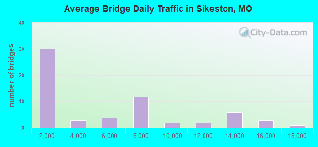
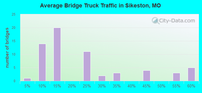
Bridge Statistics for Sikeston, Missouri (MO)
Condition, Traffic, Stress, Structural Evaluation, Project Costs
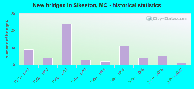
- New bridges - historical statistics
- 91940-1949
- 41950-1959
- 241960-1969
- 31970-1979
- 21980-1989
- 111990-1999
- 42000-2009
- 52010-2019
- 12020-2022
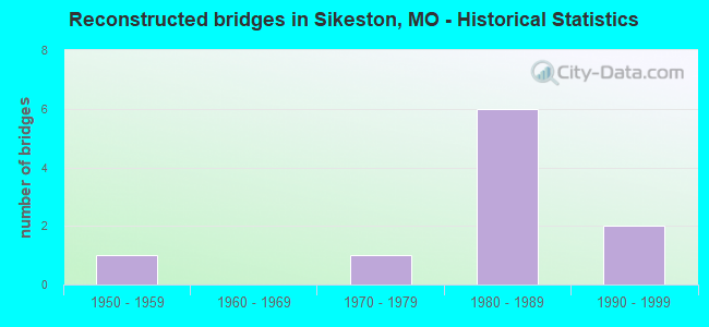
- Reconstructed bridges - Historical Statistics
- 11950-1959
- 01960-1969
- 11970-1979
- 61980-1989
- 21990-1999
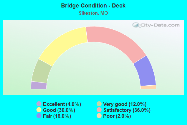
- Bridge Condition - Deck
- 4.0%Excellent
- 12.0%Very good
- 30.0%Good
- 36.0%Satisfactory
- 16.0%Fair
- 2.0%Poor
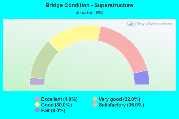
- Bridge Condition - Superstructure
- 4.0%Excellent
- 22.0%Very good
- 30.0%Good
- 36.0%Satisfactory
- 8.0%Fair
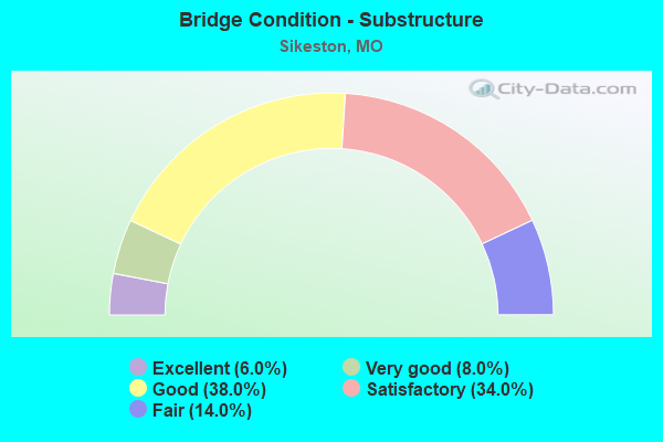
- Bridge Condition - Substructure
- 6.0%Excellent
- 8.0%Very good
- 38.0%Good
- 34.0%Satisfactory
- 14.0%Fair
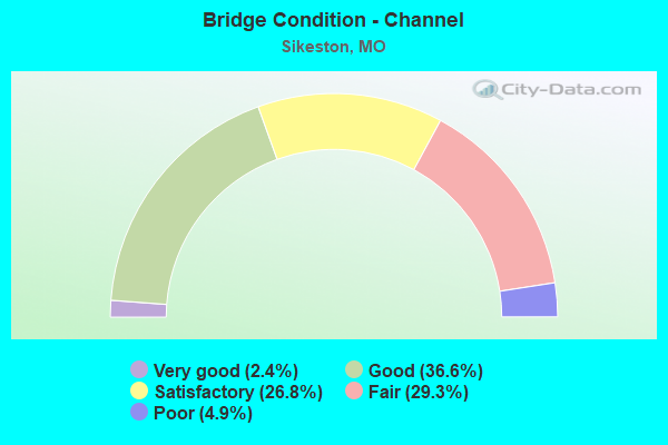
- Bridge Condition - Channel
- 2.4%Very good
- 36.6%Good
- 26.8%Satisfactory
- 29.3%Fair
- 4.9%Poor
Find on map >> Show street view
Structure Number: 6626, Location: S 14 T 26 N R 13 E (Lat: 36.890314, Lng: -89.624222), Route carried "on" structure: State highway Y, Year Built: 1956, Status: Open, Structure Length: 2.38m (7.81ft), Average Daily Traffic: 2,403 (year 2021), Truck Traffic: 3%, Average Future Daily Traffic: 3,965 (year 2041), Design Load: H 15, Features Intersected: DRAIN DTCH 4, DIST
Minimum Vertical Clearance: 30+ m (98+ ft), Kilometerpoint: 33.399, Lanes on structure: 2, Owner: State Highway Agency, Approaching Roadway Width: 6.7m (22.0ft), Material/Design: Concrete continuous, Design/Construction: Slab, Number Of Spans In Main Unit: 3, Length of Maximum Span: 7.6m (24.9ft), Curb-To-Curb Width: 7.3m (24.0ft), Out-to-Out Width: 8.4m (27.6ft)
Condition: Deck: Satisfactory, Superstructure: Satisfactory, Substructure: Good, Channel: Satisfactory, Operating Rating: 39.6 metric tons, Method Used To Determine Operating Rating: Load Factor (LF), Inventory Rating: 23.4 metric tons, Method Used To Determine Inventory Rating: Load Factor (LF), Structural Evaluation: Equal to present minimum criteria, Deck Geometry: High priority of replacement, Waterway Adequacy: Equal to present desirable criteria, Approach Roadway Alignment: Equal to present desirable criteria, Length Of Structure Improvement: 0.32m (1.05ft), Designated Inspection Frequency: Every 24 months, Inspection Date: Febuary 2021, Bridge Improvement Cost: $274,000, Roadway Improvement Cost: $27,000, Total Project Cost: $411,000 ( Estimate for 2022), Deck Structure Type: Concrete Cast-file-Place, Wearing Surface/Protective System: Wearing Surface: Bituminous
Find on map >> Show street view
Structure Number: 693, Location: S 15 T 26 N R 14 E (Lat: 36.892658, Lng: -89.533547), Route carried "on" structure: Interstate 55, Year Built: 1962, Status: Open, Structure Length: 8.50m (27.89ft), Average Daily Traffic: 7,990 (year 2021), Truck Traffic: 34%, Average Future Daily Traffic: 15,181 (year 2041), Design Load: HS 20+Mod, Features Intersected: US 62, UP RR
Minimum Vertical Clearance: 30+ m (98+ ft), Kilometerpoint: 229.057, Lanes on structure: 3, Lanes under structure: 4, Base Highway Network: Yes, Owner: State Highway Agency, Approaching Roadway Width: 15.2m (49.9ft), Skew: 11 degrees, Material/Design: Steel continuous, Design/Construction: Stringer/Multi-beam, Number Of Spans In Main Unit: 4, Length of Maximum Span: 25.0m (82.0ft), Curb-To-Curb Width: 12.5m (41.0ft), Out-to-Out Width: 13.3m (43.6ft)
Condition: Deck: Poor, Superstructure: Good, Substructure: Good, Operating Rating: 52.2 metric tons, Method Used To Determine Operating Rating: Load Factor (LF), Inventory Rating: 31.5 metric tons, Method Used To Determine Inventory Rating: Load Factor (LF), Structural Evaluation: Better than present minimum criteria, Deck Geometry: Meets minimum limits, Underclear: Equal to present minimum criteria, Approach Roadway Alignment: Equal to present desirable criteria, Designated Inspection Frequency: Every 24 months, Inspection Date: Febuary 2021, Deck Structure Type: Concrete Cast-file-Place, Wearing Surface/Protective System: Wearing Surface: Monolithic Concrete, Deck Protection: Epoxy Coated Reinforcing
Find on map >> Show street view
Structure Number: 694, Location: S 15 T 26 N R 14 E (Lat: 36.892694, Lng: -89.533222), Route carried "on" structure: Interstate 55, Year Built: 1962, Status: Open, Structure Length: 8.50m (27.89ft), Average Daily Traffic: 11,333 (year 2021), Truck Traffic: 34%, Average Future Daily Traffic: 21,533 (year 2041), Design Load: HS 20+Mod, Features Intersected: US 62, UP RR
Minimum Vertical Clearance: 30+ m (98+ ft), Kilometerpoint: 108.589, Lanes on structure: 3, Lanes under structure: 6, Base Highway Network: Yes, Owner: State Highway Agency, Approaching Roadway Width: 15.2m (49.9ft), Skew: 11 degrees, Material/Design: Steel continuous, Design/Construction: Stringer/Multi-beam, Number Of Spans In Main Unit: 4, Length of Maximum Span: 25.0m (82.0ft), Curb-To-Curb Width: 12.5m (41.0ft), Out-to-Out Width: 13.3m (43.6ft)
Condition: Deck: Fair, Superstructure: Good, Substructure: Good, Operating Rating: 52.2 metric tons, Method Used To Determine Operating Rating: Load Factor (LF), Inventory Rating: 31.5 metric tons, Method Used To Determine Inventory Rating: Load Factor (LF), Structural Evaluation: Better than present minimum criteria, Deck Geometry: Meets minimum limits, Underclear: Equal to present minimum criteria, Approach Roadway Alignment: Equal to present desirable criteria, Designated Inspection Frequency: Every 24 months, Inspection Date: Febuary 2021, Deck Structure Type: Concrete Cast-file-Place, Wearing Surface/Protective System: Wearing Surface: Monolithic Concrete, Deck Protection: Epoxy Coated Reinforcing
Find on map >> Show street view
Structure Number: 695, Location: S 27 T 26 N R 14 E (Lat: 36.873375, Lng: -89.533242), Route carried "on" structure: Interstate 55, Year Built: 1962, Status: Open, Structure Length: 8.35m (27.40ft), Average Daily Traffic: 11,333 (year 2021), Truck Traffic: 34%, Average Future Daily Traffic: 21,533 (year 2041), Design Load: HS 20+Mod, Features Intersected: IS 57
Minimum Vertical Clearance: 30+ m (98+ ft), Kilometerpoint: 231.192, Lanes on structure: 3, Lanes under structure: 6, Base Highway Network: Yes, Owner: State Highway Agency, Approaching Roadway Width: 15.2m (49.9ft), Skew: 12 degrees, Material/Design: Steel continuous, Design/Construction: Stringer/Multi-beam, Number Of Spans In Main Unit: 4, Length of Maximum Span: 24.4m (80.1ft), Curb-To-Curb Width: 11.9m (39.0ft), Out-to-Out Width: 13.0m (42.7ft)
Condition: Deck: Very good, Superstructure: Very good, Substructure: Good, Operating Rating: 47.7 metric tons, Method Used To Determine Operating Rating: Load Factor (LF), Inventory Rating: 28.8 metric tons, Method Used To Determine Inventory Rating: Load Factor (LF), Structural Evaluation: Better than present minimum criteria, Deck Geometry: High priority of replacement, Underclear: High priority of corrective action, Approach Roadway Alignment: Equal to present desirable criteria, Length Of Structure Improvement: 0.93m (3.05ft), Designated Inspection Frequency: Every 24 months, Inspection Date: Febuary 2021, Bridge Improvement Cost: $983,000, Roadway Improvement Cost: $98,000, Total Project Cost: $1,474,000 ( Estimate for 2022), Deck Structure Type: Concrete Cast-file-Place, Wearing Surface/Protective System: Wearing Surface: Monolithic Concrete, Deck Protection: Epoxy Coated Reinforcing
Find on map >> Show street view
Structure Number: 696, Location: S 27 T 26 N R 14 E (Lat: 36.873647, Lng: -89.532925), Route carried "on" structure: Interstate 55, Year Built: 1962, Status: Open, Structure Length: 8.35m (27.40ft), Average Daily Traffic: 13,218 (year 2021), Truck Traffic: 59%, Average Future Daily Traffic: 25,114 (year 2041), Design Load: HS 20+Mod, Features Intersected: IS 57
Minimum Vertical Clearance: 30+ m (98+ ft), Kilometerpoint: 106.478, Lanes on structure: 3, Lanes under structure: 6, Base Highway Network: Yes, Owner: State Highway Agency, Approaching Roadway Width: 15.2m (49.9ft), Skew: 12 degrees, Material/Design: Steel continuous, Design/Construction: Stringer/Multi-beam, Number Of Spans In Main Unit: 4, Length of Maximum Span: 24.4m (80.1ft), Curb-To-Curb Width: 11.9m (39.0ft), Out-to-Out Width: 13.0m (42.7ft)
Condition: Deck: Very good, Superstructure: Very good, Substructure: Good, Operating Rating: 47.7 metric tons, Method Used To Determine Operating Rating: Load Factor (LF), Inventory Rating: 28.8 metric tons, Method Used To Determine Inventory Rating: Load Factor (LF), Structural Evaluation: Better than present minimum criteria, Deck Geometry: High priority of replacement, Underclear: High priority of corrective action, Approach Roadway Alignment: Equal to present desirable criteria, Length Of Structure Improvement: 0.93m (3.05ft), Designated Inspection Frequency: Every 24 months, Inspection Date: Febuary 2021, Bridge Improvement Cost: $983,000, Roadway Improvement Cost: $98,000, Total Project Cost: $1,474,000 ( Estimate for 2022), Deck Structure Type: Concrete Cast-file-Place, Wearing Surface/Protective System: Wearing Surface: Monolithic Concrete
Find on map >> Show street view
Structure Number: 8141, Location: S 27 T 26 N R 14 E (Lat: 36.871978, Lng: -89.537778), Route carried "on" structure: State highway AA, Year Built: 1962, Status: Posted for load, Structure Length: 7.80m (25.59ft), Average Daily Traffic: 1,664 (year 2021), Truck Traffic: 5%, Average Future Daily Traffic: 2,413 (year 2041), Design Load: H 15, Features Intersected: US 60
Minimum Vertical Clearance: 30+ m (98+ ft), Kilometerpoint: 2.103, Lanes on structure: 2, Lanes under structure: 6, Owner: State Highway Agency, Approaching Roadway Width: 6.1m (20.0ft), Skew: 2 degrees, Material/Design: Steel continuous, Design/Construction: Stringer/Multi-beam, Number Of Spans In Main Unit: 4, Length of Maximum Span: 24.4m (80.1ft), Curb-To-Curb Width: 6.7m (22.0ft), Out-to-Out Width: 7.5m (24.6ft)
Condition: Deck: Fair, Superstructure: Satisfactory, Substructure: Satisfactory, Operating Rating: 22.5 metric tons, Method Used To Determine Operating Rating: Load Factor (LF), Inventory Rating: 13.5 metric tons, Method Used To Determine Inventory Rating: Load Factor (LF), Structural Evaluation: Meets minimum limits, Deck Geometry: High priority of corrective action, Underclear: High priority of replacement, Approach Roadway Alignment: Equal to present minimum criteria, Bridge Posting: Required (Relationship of Operating Rating to Maximum Legal Load: 10.0 - 19.9% below), Length Of Structure Improvement: 0.88m (2.89ft), Designated Inspection Frequency: Every 24 months, Inspection Date: Febuary 2021, Bridge Improvement Cost: $1,006,000, Roadway Improvement Cost: $101,000, Total Project Cost: $1,508,000 ( Estimate for 2022), Deck Structure Type: Concrete Cast-file-Place, Wearing Surface/Protective System: Wearing Surface: Bituminous
Find on map >> Show street view
Structure Number: 8298, Location: S 34 T 26 N R 14 E (Lat: 36.855397, Lng: -89.532800), Route carried "on" structure: State highway AA, Year Built: 1964, Status: Open, Structure Length: 7.89m (25.89ft), Average Daily Traffic: 863 (year 2021), Truck Traffic: 11%, Average Future Daily Traffic: 1,338 (year 2041), Design Load: H 15, Features Intersected: IS 55
Minimum Vertical Clearance: 30+ m (98+ ft), Kilometerpoint: 4.210, Lanes on structure: 2, Lanes under structure: 4, Owner: State Highway Agency, Approaching Roadway Width: 6.1m (20.0ft), Skew: 2 degrees, Material/Design: Concrete continuous, Design/Construction: Slab, Number Of Spans In Main Unit: 4, Length of Maximum Span: 21.3m (69.9ft), Curb-To-Curb Width: 7.3m (24.0ft), Out-to-Out Width: 8.4m (27.6ft)
Condition: Deck: Satisfactory, Superstructure: Satisfactory, Substructure: Good, Operating Rating: 27.0 metric tons, Method Used To Determine Operating Rating: Load Factor (LF), Inventory Rating: 16.2 metric tons, Method Used To Determine Inventory Rating: Load Factor (LF), Structural Evaluation: Meets minimum limits, Deck Geometry: Meets minimum limits, Underclear: Meets minimum limits, Approach Roadway Alignment: Equal to present minimum criteria, Designated Inspection Frequency: Every 24 months, Inspection Date: December 2020, Deck Structure Type: Concrete Cast-file-Place, Wearing Surface/Protective System: Wearing Surface: Bituminous
Find on map >> Show street view
Structure Number: 933, Location: S 10 T 25 N R 14 E (Lat: 36.823278, Lng: -89.532494), Route carried "on" structure: Interstate 55, Year Built: 1964, Status: Open, Structure Length: 7.62m (25.00ft), Average Daily Traffic: 13,218 (year 2021), Truck Traffic: 59%, Average Future Daily Traffic: 24,453 (year 2041), Design Load: HS 20+Mod, Features Intersected: N CUT DTCH
Minimum Vertical Clearance: 30+ m (98+ ft), Kilometerpoint: 236.764, Lanes on structure: 2, Base Highway Network: Yes, Owner: State Highway Agency, Approaching Roadway Width: 11.0m (36.1ft), Skew: 5 degrees, Material/Design: Steel continuous, Design/Construction: Stringer/Multi-beam, Number Of Spans In Main Unit: 5, Length of Maximum Span: 16.5m (54.1ft), Curb-To-Curb Width: 9.1m (29.9ft), Out-to-Out Width: 10.2m (33.5ft)
Condition: Deck: Fair, Superstructure: Good, Substructure: Satisfactory, Channel: Fair, Operating Rating: 44.1 metric tons, Method Used To Determine Operating Rating: Load Factor (LF), Inventory Rating: 26.1 metric tons, Method Used To Determine Inventory Rating: Load Factor (LF), Structural Evaluation: Equal to present minimum criteria, Deck Geometry: Meets minimum limits, Waterway Adequacy: Equal to present desirable criteria, Approach Roadway Alignment: Equal to present desirable criteria, Designated Inspection Frequency: Every 24 months, Inspection Date: December 2021, Deck Structure Type: Concrete Cast-file-Place, Wearing Surface/Protective System: Wearing Surface: Monolithic Concrete
Find on map >> Show street view
Structure Number: 934, Location: S 10 T 25 N R 14 E (Lat: 36.823722, Lng: -89.532214), Route carried "on" structure: Interstate 55, Year Built: 1964, Status: Open, Structure Length: 7.62m (25.00ft), Average Daily Traffic: 13,218 (year 2021), Truck Traffic: 59%, Average Future Daily Traffic: 24,453 (year 2041), Design Load: HS 20+Mod, Features Intersected: N CUT DTCH
Minimum Vertical Clearance: 30+ m (98+ ft), Kilometerpoint: 100.924, Lanes on structure: 2, Base Highway Network: Yes, Owner: State Highway Agency, Approaching Roadway Width: 11.0m (36.1ft), Skew: 5 degrees, Material/Design: Steel continuous, Design/Construction: Stringer/Multi-beam, Number Of Spans In Main Unit: 5, Length of Maximum Span: 16.5m (54.1ft), Curb-To-Curb Width: 9.1m (29.9ft), Out-to-Out Width: 10.2m (33.5ft)
Condition: Deck: Fair, Superstructure: Good, Substructure: Satisfactory, Channel: Fair, Operating Rating: 44.1 metric tons, Method Used To Determine Operating Rating: Load Factor (LF), Inventory Rating: 26.1 metric tons, Method Used To Determine Inventory Rating: Load Factor (LF), Structural Evaluation: Equal to present minimum criteria, Deck Geometry: Meets minimum limits, Waterway Adequacy: Equal to present desirable criteria, Approach Roadway Alignment: Equal to present desirable criteria, Designated Inspection Frequency: Every 24 months, Inspection Date: December 2021, Deck Structure Type: Concrete Cast-file-Place, Wearing Surface/Protective System: Wearing Surface: Monolithic Concrete
Find on map >> Show street view
Structure Number: 4096, Location: S 689 T 26 N R 14 E (Lat: 36.855806, Lng: -89.582625), Route carried "under" structure: US 61, Year Built: 1992, Structure Length: 0. m, Average Daily Traffic: 15,130 (year 2021), Truck Traffic: 6%, Features Intersected: US 61, Facility Carried by Structure: US 60 E
Minimum Vertical Clearance: 5.13m (16.83ft), Kilometerpoint: 522.034, Lanes on structure: 2, Lanes under structure: 4, Material/Design: Steel continuous, Design/Construction: Stringer/Multi-beam, Length of Maximum Span: 29.6m (97.1ft)
Find on map >> Show street view
Structure Number: 4097, Location: S 689 T 26 N R 14 E (Lat: 36.855875, Lng: -89.583164), Route carried "under" structure: US 61, Year Built: 1992, Structure Length: 0. m, Average Daily Traffic: 15,130 (year 2021), Truck Traffic: 6%, Features Intersected: US 61, Facility Carried by Structure: US 60 W
Minimum Vertical Clearance: 5.11m (16.77ft), Kilometerpoint: 522.006, Lanes on structure: 2, Lanes under structure: 4, Material/Design: Steel continuous, Design/Construction: Stringer/Multi-beam, Length of Maximum Span: 29.6m (97.1ft)
Find on map >> Show street view
Structure Number: 693, Location: S 15 T 26 N R 14 E (Lat: 36.892658, Lng: -89.533547), Route carried "under" structure: US 62, Year Built: 1962, Structure Length: 0. m, Average Daily Traffic: 16,534 (year 2021), Truck Traffic: 7%, Features Intersected: US 62, Facility Carried by Structure: IS 55 S
Minimum Vertical Clearance: 6.86m (22.51ft), Kilometerpoint: 100.137, Lanes on structure: 3, Lanes under structure: 4, Material/Design: Steel continuous, Design/Construction: Stringer/Multi-beam, Length of Maximum Span: 25.0m (82.0ft)
Find on map >> Show street view
Structure Number: 694, Location: S 15 T 26 N R 14 E (Lat: 36.892694, Lng: -89.533222), Route carried "under" structure: US 62, Year Built: 1962, Structure Length: 0. m, Average Daily Traffic: 14,249 (year 2021), Truck Traffic: 7%, Features Intersected: US 62, Facility Carried by Structure: IS 55 N
Minimum Vertical Clearance: 6.91m (22.67ft), Kilometerpoint: 100.166, Lanes on structure: 3, Lanes under structure: 6, Material/Design: Steel continuous, Design/Construction: Stringer/Multi-beam, Length of Maximum Span: 25.0m (82.0ft)
Find on map >> Show street view
Structure Number: 695, Location: S 27 T 26 N R 14 E (Lat: 36.873375, Lng: -89.533242), Route carried "under" structure: Interstate 57, Year Built: 1962, Structure Length: 0. m, Average Daily Traffic: 6,900 (year 2021), Truck Traffic: 40%, Features Intersected: IS 57, Facility Carried by Structure: IS 55 S
Minimum Vertical Clearance: 4.95m (16.24ft), Kilometerpoint: 35.522, Lanes on structure: 3, Lanes under structure: 3, Material/Design: Steel continuous, Design/Construction: Stringer/Multi-beam, Length of Maximum Span: 24.4m (80.1ft)
Find on map >> Show street view
Structure Number: 695, Location: S 27 T 26 N R 14 E (Lat: 36.873375, Lng: -89.533242), Route carried "under" structure: Interstate 57, Year Built: 1962, Structure Length: 0. m, Average Daily Traffic: 9,103 (year 2021), Truck Traffic: 44%, Features Intersected: IS 57, Facility Carried by Structure: IS 55 S
Minimum Vertical Clearance: 4.95m (16.24ft), Kilometerpoint: 0.385, Lanes on structure: 3, Lanes under structure: 3, Material/Design: Steel continuous, Design/Construction: Stringer/Multi-beam, Length of Maximum Span: 24.4m (80.1ft)
Find on map >> Show street view
Structure Number: 696, Location: S 27 T 26 N R 14 E (Lat: 36.873647, Lng: -89.532925), Route carried "under" structure: Interstate 57, Year Built: 1962, Structure Length: 0. m, Average Daily Traffic: 6,900 (year 2021), Truck Traffic: 40%, Features Intersected: IS 57, Facility Carried by Structure: IS 55 N
Minimum Vertical Clearance: 4.95m (16.24ft), Kilometerpoint: 35.489, Lanes on structure: 3, Lanes under structure: 3, Material/Design: Steel continuous, Design/Construction: Stringer/Multi-beam, Length of Maximum Span: 24.4m (80.1ft)
Find on map >> Show street view
Structure Number: 696, Location: S 27 T 26 N R 14 E (Lat: 36.873647, Lng: -89.532925), Route carried "under" structure: Interstate 57, Year Built: 1962, Structure Length: 0. m, Average Daily Traffic: 9,103 (year 2021), Truck Traffic: 44%, Features Intersected: IS 57, Facility Carried by Structure: IS 55 N
Minimum Vertical Clearance: 4.95m (16.24ft), Kilometerpoint: 0.415, Lanes on structure: 3, Lanes under structure: 3, Material/Design: Steel continuous, Design/Construction: Stringer/Multi-beam, Length of Maximum Span: 24.4m (80.1ft)
Find on map >> Show street view
Structure Number: 8141, Location: S 27 T 26 N R 14 E (Lat: 36.871978, Lng: -89.537778), Route carried "under" structure: US 60, Year Built: 1962, Structure Length: 0. m, Average Daily Traffic: 4,461 (year 2021), Truck Traffic: 29%, Features Intersected: US 60, Facility Carried by Structure: RT AA S
Minimum Vertical Clearance: 4.67m (15.32ft), Kilometerpoint: 509.580, Lanes on structure: 2, Lanes under structure: 3, Material/Design: Steel continuous, Design/Construction: Stringer/Multi-beam, Length of Maximum Span: 24.4m (80.1ft)
Find on map >> Show street view
Structure Number: 8141, Location: S 27 T 26 N R 14 E (Lat: 36.871978, Lng: -89.537778), Route carried "under" structure: US 60, Year Built: 1962, Structure Length: 0. m, Average Daily Traffic: 4,609 (year 2021), Truck Traffic: 22%, Features Intersected: US 60, Facility Carried by Structure: RT AA S
Minimum Vertical Clearance: 4.67m (15.32ft), Kilometerpoint: 39.632, Lanes on structure: 2, Lanes under structure: 3, Material/Design: Steel continuous, Design/Construction: Stringer/Multi-beam, Length of Maximum Span: 24.4m (80.1ft)
Find on map >> Show street view
Structure Number: 8298, Location: S 34 T 26 N R 14 E (Lat: 36.855397, Lng: -89.532800), Route carried "under" structure: Interstate 55, Year Built: 1964, Structure Length: 0. m, Average Daily Traffic: 13,218 (year 2021), Truck Traffic: 59%, Features Intersected: IS 55, Facility Carried by Structure: RT AA S
Minimum Vertical Clearance: 4.93m (16.17ft), Kilometerpoint: 233.230, Lanes on structure: 2, Lanes under structure: 2, Material/Design: Concrete continuous, Design/Construction: Slab, Length of Maximum Span: 21.3m (69.9ft)
Find on map >> Show street view
Structure Number: 8298, Location: S 34 T 26 N R 14 E (Lat: 36.855397, Lng: -89.532800), Route carried "under" structure: Interstate 55, Year Built: 1964, Structure Length: 0. m, Average Daily Traffic: 13,218 (year 2021), Truck Traffic: 59%, Features Intersected: IS 55, Facility Carried by Structure: RT AA S
Minimum Vertical Clearance: 4.95m (16.24ft), Kilometerpoint: 104.476, Lanes on structure: 2, Lanes under structure: 2, Material/Design: Concrete continuous, Design/Construction: Slab, Length of Maximum Span: 21.3m (69.9ft)