Bridge Statistics for Smyrna, Georgia (GA)
Condition, Traffic, Stress, Structural Evaluation, Project Costs
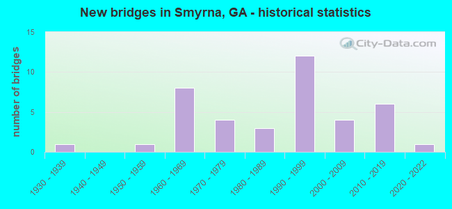
- New bridges - historical statistics
- 11930-1939
- 11950-1959
- 81960-1969
- 41970-1979
- 31980-1989
- 121990-1999
- 42000-2009
- 62010-2019
- 12020-2022

- Reconstructed bridges - Historical Statistics
- 61970-1979
- 21980-1989
- 11990-1999
- 02000-2009
- 12010-2019


- Bridge Condition - Deck
- 6.1%Very good
- 84.8%Good
- 9.1%Satisfactory

- Bridge Condition - Superstructure
- 30.3%Very good
- 69.7%Good

- Bridge Condition - Substructure
- 9.1%Very good
- 84.8%Good
- 3.0%Satisfactory
- 3.0%Fair

- Bridge Condition - Channel
- 5.3%Excellent
- 52.6%Very good
- 36.8%Good
- 5.3%Satisfactory
Find on map >> Show street view
Structure Number: 6701, Location: 6.7 MI SE OF MARIETTA (Lat: 33.889228, Lng: -84.462689), Route carried "under" structure: Ramp Interstate 285, Structure Length: 0. m, Average Daily Traffic: 17,050 (year 2009), Truck Traffic: 1%, Features Intersected: I-285
Minimum Vertical Clearance: 5.28m (17.32ft), Kilometerpoint: 32.187, Lanes on structure: 5, Length of Maximum Span: 0.0m
Find on map >> Show street view
Structure Number: 670101, Location: 6.7 MI SE OF MARIETTA (Lat: 33.890269, Lng: -84.460769), Route carried "under" structure: Interstate 75, Structure Length: 0. m, Average Daily Traffic: 236,400 (year 1998), Truck Traffic: 1%, Features Intersected: I-285, Facility Carried by Structure: I-285
Minimum Vertical Clearance: 10.46m (34.32ft), Kilometerpoint: 416.820, Lanes on structure: 5, Length of Maximum Span: 0.0m
Find on map >> Show street view
Structure Number: 670104, Location: 6.7 MI SE OF MARIETTA (Lat: 33.892047, Lng: -84.459261), Route carried "under" structure: Ramp Interstate 285, Structure Length: 0. m, Average Daily Traffic: 25,100 (year 2010), Truck Traffic: 1%, Features Intersected: I-285 RAMP CCBL- CD
Minimum Vertical Clearance: 5.43m (17.81ft), Kilometerpoint: 32.187, Lanes on structure: 2, Length of Maximum Span: 0.0m
Find on map >> Show street view
Structure Number: 670129, Location: 3.2 MI E OF SMYRNA (Lat: 33.880089, Lng: -84.473189), Route carried "under" structure: Interstate 285, Structure Length: 0. m, Average Daily Traffic: 166,600 (year 1998), Truck Traffic: 1%, Features Intersected: M-9016 HARGROVE ROAD, Facility Carried by Structure: CUMBERLAND BLVD.
Minimum Vertical Clearance: 5.84m (19.16ft), Kilometerpoint: 30.578, Lanes on structure: 4, Length of Maximum Span: 0.0m
Find on map >> Show street view
Structure Number: 670129, Location: 3.2 MI E OF SMYRNA (Lat: 33.880089, Lng: -84.473189), Route carried "under" structure: County highway 1951, Structure Length: 0. m, Average Daily Traffic: 2,700 (year 1994), Truck Traffic: 1%, Features Intersected: M-9016 HARGROVE ROAD, Facility Carried by Structure: CUMBERLAND BLVD.
Minimum Vertical Clearance: 5.20m (17.06ft), Kilometerpoint: 0.000, Lanes on structure: 4, Length of Maximum Span: 0.0m
Find on map >> Show street view
Structure Number: 670187, Location: 0.9 N OF I-285 & I-75 INT (Lat: 33.898008, Lng: -84.468408), Route carried "under" structure: Ramp Interstate 75, Structure Length: 0. m, Average Daily Traffic: 13,100 (year 2009), Truck Traffic: 1%, Features Intersected: I-285 RAMP TO I-75 NB
Minimum Vertical Clearance: 5.43m (17.81ft), Kilometerpoint: 418.430, Lanes on structure: 4, Length of Maximum Span: 0.0m
Find on map >> Show street view
Structure Number: 670195, Location: 0.87 NW I-75 & I-285 INT (Lat: 33.896178, Lng: -84.467439), Route carried "under" structure: Ramp Interstate 75, Structure Length: 0. m, Average Daily Traffic: 25,100 (year 1998), Truck Traffic: 1%, Features Intersected: I-75R WINDY HILL TO I-75
Minimum Vertical Clearance: 6.09m (19.98ft), Kilometerpoint: 416.820, Lanes on structure: 1, Length of Maximum Span: 0.0m
Find on map >> Show street view
Structure Number: 670196, Location: I-285 & I-75 INTERCHANGE (Lat: 33.889897, Lng: -84.461067), Route carried "under" structure: Ramp Interstate 285, Structure Length: 0. m, Average Daily Traffic: 6,750 (year 1996), Truck Traffic: 1%, Features Intersected: I-75 RAMP TO I-285 EB
Minimum Vertical Clearance: 14.57m (47.80ft), Kilometerpoint: 32.187, Lanes on structure: 2, Length of Maximum Span: 0.0m
Find on map >> Show street view
Structure Number: 670196, Location: I-285 & I-75 INTERCHANGE (Lat: 33.889897, Lng: -84.461067), Route carried "under" structure: Interstate 285, Structure Length: 0. m, Average Daily Traffic: 169,200 (year 1994), Truck Traffic: 1%, Features Intersected: I-75 RAMP TO I-285 EB
Minimum Vertical Clearance: 8.71m (28.58ft), Kilometerpoint: 32.187, Lanes on structure: 2, Length of Maximum Span: 0.0m
Find on map >> Show street view
Structure Number: 670196, Location: I-285 & I-75 INTERCHANGE (Lat: 33.889897, Lng: -84.461067), Route carried "under" structure: Ramp Interstate 285, Structure Length: 0. m, Average Daily Traffic: 21,250 (year 1996), Truck Traffic: 1%, Features Intersected: I-75 RAMP TO I-285 EB
Minimum Vertical Clearance: 17.93m (58.83ft), Kilometerpoint: 32.187, Lanes on structure: 2, Length of Maximum Span: 0.0m
Find on map >> Show street view
Structure Number: 670196, Location: I-285 & I-75 INTERCHANGE (Lat: 33.889897, Lng: -84.461067), Route carried "under" structure: Ramp Interstate 401, Structure Length: 0. m, Average Daily Traffic: 180,000 (year 1998), Truck Traffic: 11%, Features Intersected: I-75 RAMP TO I-285, Facility Carried by Structure: I-75 RAMP TO I-285
Minimum Vertical Clearance: 5.68m (18.64ft), Kilometerpoint: 416.820, Lanes on structure: 2, Length of Maximum Span: 0.0m
Find on map >> Show street view
Structure Number: 670196, Location: I-285 & I-75 INTERCHANGE (Lat: 33.889897, Lng: -84.461067), Route carried "under" structure: Ramp Interstate 75, Structure Length: 0. m, Average Daily Traffic: 9,850 (year 1995), Truck Traffic: 1%, Features Intersected: I-75 RAMP TO I-285 EB
Minimum Vertical Clearance: 7.89m (25.89ft), Kilometerpoint: 416.820, Lanes on structure: 2, Length of Maximum Span: 0.0m
Find on map >> Show street view
Structure Number: 670196, Location: I-285 & I-75 INTERCHANGE (Lat: 33.889897, Lng: -84.461067), Route carried "under" structure: Interstate 75, Structure Length: 0. m, Average Daily Traffic: 197,800 (year 1998), Truck Traffic: 1%, Features Intersected: I-75 RAMP TO I-285 EBL
Minimum Vertical Clearance: 18.64m (61.15ft), Kilometerpoint: 416.820, Lanes on structure: 2, Length of Maximum Span: 0.0m
Find on map >> Show street view
Structure Number: 670197, Location: I-285 & I-75 INTERCHANGE (Lat: 33.890061, Lng: -84.462917), Route carried "under" structure: Ramp Interstate 285, Structure Length: 0. m, Average Daily Traffic: 25,000 (year 1998), Truck Traffic: 1%, Features Intersected: I-75 RAMP TO I-285 WB
Minimum Vertical Clearance: 5.13m (16.83ft), Kilometerpoint: 32.187, Lanes on structure: 2, Length of Maximum Span: 0.0m
Find on map >> Show street view
Structure Number: 670209, Location: 3.2 MILES SOUTH EAST OF S (Lat: 33.879569, Lng: -84.473719), Route carried "under" structure: County highway 1951, Structure Length: 0. m, Average Daily Traffic: 1,930 (year 2012), Truck Traffic: 1%, Features Intersected: SPRING HILL ROAD, Facility Carried by Structure: CSX RR (340372E)
Minimum Vertical Clearance: 5.35m (17.55ft), Kilometerpoint: 0.000, Length of Maximum Span: 0.0m
Find on map >> Show street view
Structure Number: 675138, Location: 2.5 MILES SOUTH WEST OF S (Lat: 33.852383, Lng: -84.559931), Route carried "under" structure: County highway 1781, Structure Length: 0. m, Average Daily Traffic: 1,930 (year 2012), Truck Traffic: 1%, Features Intersected: COVERED BRIDGE ROAD, Facility Carried by Structure: SILVER COMET TRAIL
Minimum Vertical Clearance: 8.96m (29.40ft), Kilometerpoint: 1.609, Length of Maximum Span: 0.0m
Find on map >> Show street view
Structure Number: 675148, Location: 3.7 MI E OF SMYRNA (Lat: 33.894128, Lng: -84.460700), Route carried "under" structure: County highway 3068, Structure Length: 0. m, Average Daily Traffic: 8,980 (year 2012), Truck Traffic: 1%, Features Intersected: INTERSTATE NORTH PKY, Facility Carried by Structure: PEDESTRIAN OVERPAS
Minimum Vertical Clearance: 5.08m (16.67ft), Kilometerpoint: 1.609, Length of Maximum Span: 0.0m
Find on map >> Show street view
Structure Number: 67518, Location: 3 MILES SOUTH WEST OF SMY (Lat: 33.852869, Lng: -84.557481), Route carried "under" structure: County highway 2835, Structure Length: 0. m, Average Daily Traffic: 21,500 (year 1998), Truck Traffic: 1%, Features Intersected: CR-1782 CONCORD RD, Facility Carried by Structure: CONCORD ROAD
Minimum Vertical Clearance: 6.17m (20.24ft), Kilometerpoint: 8.047, Lanes on structure: 2, Length of Maximum Span: 0.0m
Find on map >> Show street view
Structure Number: 675191, Location: 3 MI. EAST OF SMYRNA (Lat: 33.894367, Lng: -84.464489), Route carried "under" structure: Ramp Interstate 75, Structure Length: 0. m, Average Daily Traffic: 22,400 (year 1999), Truck Traffic: 1%, Features Intersected: M-9036 WINDY RIDGE PKWY, Facility Carried by Structure: WINDY RIDGE PARKWA
Minimum Vertical Clearance: 6.01m (19.72ft), Kilometerpoint: 416.820, Lanes on structure: 5, Length of Maximum Span: 0.0m
Find on map >> Show street view
Structure Number: 675191, Location: 3 MI. EAST OF SMYRNA (Lat: 33.894367, Lng: -84.464489), Route carried "under" structure: Ramp Interstate 75, Structure Length: 0. m, Average Daily Traffic: 22,400 (year 1999), Truck Traffic: 1%, Features Intersected: M-9036 WINDY RIDGE PKWY., Facility Carried by Structure: WINDY RIDGE PARKWA
Minimum Vertical Clearance: 6.42m (21.06ft), Kilometerpoint: 416.820, Lanes on structure: 5, Length of Maximum Span: 0.0m
Find on map >> Show street view
Structure Number: 675191, Location: 3 MI. EAST OF SMYRNA (Lat: 33.894367, Lng: -84.464489), Route carried "under" structure: Ramp Interstate 75, Structure Length: 0. m, Average Daily Traffic: 22,400 (year 1999), Truck Traffic: 1%, Features Intersected: M-9036 WINDY RIDGE PKWY., Facility Carried by Structure: WINDY RIDGE PARKWA
Minimum Vertical Clearance: 5.35m (17.55ft), Kilometerpoint: 32.187, Lanes on structure: 5, Length of Maximum Span: 0.0m
Find on map >> Show street view
Structure Number: 675191, Location: 3 MI. EAST OF SMYRNA (Lat: 33.894367, Lng: -84.464489), Route carried "under" structure: Interstate 75, Structure Length: 0. m, Average Daily Traffic: 190,500 (year 1999), Truck Traffic: 1%, Features Intersected: M-9036 WINDY RIDGE PKWY, Facility Carried by Structure: WINDY RIDGE PARKWA
Minimum Vertical Clearance: 9.09m (29.82ft), Kilometerpoint: 416.820, Lanes on structure: 5, Length of Maximum Span: 0.0m
Find on map >> Show street view
Structure Number: 675191, Location: 3 MI. EAST OF SMYRNA (Lat: 33.894367, Lng: -84.464489), Route carried "under" structure: Alternate Interstate 75, Structure Length: 0. m, Average Daily Traffic: 22,490 (year 1999), Truck Traffic: 1%, Features Intersected: M-9036 WINDY RIDGE PKWY., Facility Carried by Structure: WINDY RIDGE PARKWA
Minimum Vertical Clearance: 6.75m (22.15ft), Kilometerpoint: 32.187, Lanes on structure: 5, Toll: On toll road, Length of Maximum Span: 0.0m
Find on map >> Show street view
Structure Number: 675236, Location: 6.7 MILES SE OF MARIETTA (Lat: 33.892719, Lng: -84.457358), Route carried "under" structure: County highway 2666, Structure Length: 0. m, Average Daily Traffic: 5,000 (year 2003), Truck Traffic: 12%, Features Intersected: I-285 RAMP CCBL, Facility Carried by Structure: I-285 RAMP CCBL
Minimum Vertical Clearance: 7.82m (25.66ft), Kilometerpoint: 0.000, Lanes on structure: 2, Length of Maximum Span: 0.0m
Find on map >> Show street view
Structure Number: 675237, Location: 6.7 MILES SOUTH EAST OF M (Lat: 33.892969, Lng: -84.457419), Route carried "under" structure: County highway 2666, Structure Length: 0. m, Average Daily Traffic: 50,000 (year 2003), Truck Traffic: 12%, Features Intersected: SR 407 RAMP, Facility Carried by Structure: I-285R CCBL-I-75N
Minimum Vertical Clearance: 6.35m (20.83ft), Kilometerpoint: 0.000, Lanes on structure: 2, Length of Maximum Span: 0.0m
Find on map >> Show street view
Structure Number: 675259, Location: 3.2 MILES EAST OF SMYRNA (Lat: 33.880047, Lng: -84.473519), Route carried "under" structure: County highway 1951, Structure Length: 0. m, Average Daily Traffic: 1,930 (year 2012), Truck Traffic: 1%, Features Intersected: SPRING HILL ROAD, Facility Carried by Structure: PEDESTRIAN OVERPAS
Minimum Vertical Clearance: 5.63m (18.47ft), Kilometerpoint: 0.000, Length of Maximum Span: 0.0m
Find on map >> Show street view
Structure Number: 675334, Location: 6.7 MILES SOUTH EAST OF M (Lat: 33.889517, Lng: -84.463931), Route carried "under" structure: Ramp Interstate 285, Structure Length: 0. m, Average Daily Traffic: 25,000 (year 1998), Truck Traffic: 1%, Features Intersected: R 7-2SB/ML-I285WBR
Minimum Vertical Clearance: 12.39m (40.65ft), Kilometerpoint: 32.187, Lanes on structure: 2, Length of Maximum Span: 0.0m
Find on map >> Show street view
Structure Number: 675334, Location: 6.7 MILES SOUTH EAST OF M (Lat: 33.889517, Lng: -84.463931), Route carried "under" structure: Ramp Interstate 285, Structure Length: 0. m, Average Daily Traffic: 21,250 (year 1996), Truck Traffic: 1%, Features Intersected: R 7-2SB/ML-I285WBR
Minimum Vertical Clearance: 10.28m (33.73ft), Kilometerpoint: 32.187, Lanes on structure: 1, Length of Maximum Span: 0.0m
Find on map >> Show street view
Structure Number: 675335, Location: 6.7 MILES SOUTH EAST OF M (Lat: 33.889281, Lng: -84.463597), Route carried "under" structure: Ramp Interstate 285, Structure Length: 0. m, Average Daily Traffic: 25,000 (year 1998), Truck Traffic: 1%, Features Intersected: I-75/I-285/RAMP-A
Minimum Vertical Clearance: 13.43m (44.06ft), Kilometerpoint: 32.187, Lanes on structure: 2, Length of Maximum Span: 0.0m
Find on map >> Show street view
Structure Number: 675335, Location: 6.7 MILES SOUTH EAST OF M (Lat: 33.889281, Lng: -84.463597), Route carried "under" structure: Ramp Interstate 285, Structure Length: 0. m, Average Daily Traffic: 21,250 (year 1996), Truck Traffic: 1%, Features Intersected: I-75/I-285/RAMP-A
Minimum Vertical Clearance: 9.67m (31.73ft), Kilometerpoint: 32.187, Lanes on structure: 2, Length of Maximum Span: 0.0m
Find on map >> Show street view
Structure Number: 675335, Location: 6.7 MILES SOUTH EAST OF M (Lat: 33.889281, Lng: -84.463597), Route carried "under" structure: Ramp Interstate 285, Structure Length: 0. m, Average Daily Traffic: 25,000 (year 1998), Truck Traffic: 1%, Features Intersected: I-75/I-285/RAMP-A
Minimum Vertical Clearance: 8.10m (26.57ft), Kilometerpoint: 32.187, Lanes on structure: 2, Length of Maximum Span: 0.0m
Find on map >> Show street view
Structure Number: 675335, Location: 6.7 MILES SOUTH EAST OF M (Lat: 33.889281, Lng: -84.463597), Route carried "under" structure: Ramp Interstate 401, Structure Length: 0. m, Average Daily Traffic: 1 (year 1901), Truck Traffic: 1%, Features Intersected: I-75/I-285/RAMP-A, Facility Carried by Structure: I-75/I-285/RAMP-A
Minimum Vertical Clearance: 11.98m (39.30ft), Kilometerpoint: 416.820, Lanes on structure: 1, Length of Maximum Span: 0.0m
Find on map >> Show street view
Structure Number: 675336, Location: 3 MILES EAST OF SMYRNA (Lat: 33.896547, Lng: -84.467281), Route carried "under" structure: Interstate 401, Structure Length: 0. m, Average Daily Traffic: 99,999 (year 2018), Truck Traffic: 99%, Features Intersected: I-75 MANAGED LANES RAMP, Facility Carried by Structure: I-75 MANAGED LANES
Minimum Vertical Clearance: 5.96m (19.55ft), Kilometerpoint: 418.430, Lanes on structure: 2, Length of Maximum Span: 0.0m
Find on map >> Show street view
Structure Number: 675336, Location: 3 MILES EAST OF SMYRNA (Lat: 33.896547, Lng: -84.467281), Route carried "under" structure: Interstate 401, Structure Length: 0. m, Average Daily Traffic: 104,200 (year 2018), Truck Traffic: 99%, Features Intersected: I-75 MANAGED LANES RAMP, Facility Carried by Structure: I-75 MANAGED LANES
Minimum Vertical Clearance: 5.99m (19.65ft), Kilometerpoint: 418.430, Lanes on structure: 2, Length of Maximum Span: 0.0m
Find on map >> Show street view
Structure Number: 675336, Location: 3 MILES EAST OF SMYRNA (Lat: 33.896547, Lng: -84.467281), Route carried "under" structure: Interstate 401, Structure Length: 0. m, Average Daily Traffic: 9,999 (year 2018), Features Intersected: I-75 MANAGED LANES RAMP, Facility Carried by Structure: I-75 MANAGED LANES
Minimum Vertical Clearance: 5.96m (19.55ft), Kilometerpoint: 418.430, Lanes on structure: 2, Toll: On toll road, Length of Maximum Span: 0.0m
Find on map >> Show street view
Structure Number: 675357, Location: 6.7 MI SE OF MARIETTA (Lat: 33.891039, Lng: -84.461458), Route carried "under" structure: Interstate 75, Structure Length: 0. m, Average Daily Traffic: 37,960 (year 2018), Truck Traffic: 22%, Features Intersected: I-285 RAMP CCBL- CD, Facility Carried by Structure: I-285 RMP CCBL- CD
Minimum Vertical Clearance: 5.20m (17.06ft), Kilometerpoint: 416.820, Lanes on structure: 3, Length of Maximum Span: 0.0m