Bridge Statistics for Somerville, Tennessee (TN)
Condition, Traffic, Stress, Structural Evaluation, Project Costs
- National Bridge Inventory (NBI) Statistics
- 41Number of bridges
- 407ft / 124mTotal length
- $14,069,000Total costs
- 187,531Total average daily traffic
- 17,220Total average daily truck traffic
- 328,998Total future (year 2040) average daily traffic
- National Bridge Inventory (NBI) Registered Bridges for Somerville
- No street view available for this location
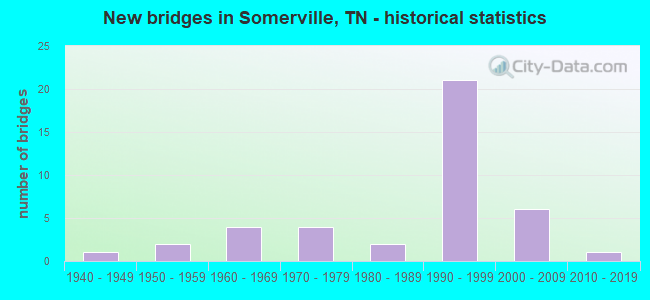
- New bridges - historical statistics
- 11940-1949
- 21950-1959
- 41960-1969
- 41970-1979
- 21980-1989
- 211990-1999
- 62000-2009
- 12010-2019

- Reconstructed bridges - Historical Statistics
- 11970-1979
- 01980-1989
- 11990-1999
- 12000-2009
- 12010-2019


- Bridge Condition - Deck
- 7.1%Very good
- 39.3%Good
- 50.0%Satisfactory
- 3.6%Fair

- Bridge Condition - Superstructure
- 3.6%Very good
- 39.3%Good
- 50.0%Satisfactory
- 3.6%Fair
- 3.6%Poor

- Bridge Condition - Substructure
- 57.1%Good
- 25.0%Satisfactory
- 7.1%Fair
- 10.7%Poor

- Bridge Condition - Channel
- 12.2%Good
- 82.9%Satisfactory
- 4.9%Fair

- Bridge Condition - Culverts
- 30.8%Good
- 38.5%Satisfactory
- 30.8%Fair
Find on map >> Show street view
Structure Number: 24014420005, Location: .9 MI SE JCT SR76 & SR195 (Lat: 35.211139, Lng: -89.344222), Route carried "on" structure: County highway 1442, Year Built: 1975, Status: Open, Structure Length: 0.67m (2.20ft), Average Daily Traffic: 752 (year 2020), Truck Traffic: 3%, Average Future Daily Traffic: 1,203 (year 2041), Features Intersected: BRANCH
Minimum Vertical Clearance: 30+ m (98+ ft), Kilometerpoint: 22.595, Lanes on structure: 2, Owner: County Highway Agency, Approaching Roadway Width: 8.5m (27.9ft), Skew: 1 degrees, Material/Design: Concrete continuous, Design/Construction: Culvert, Number Of Spans In Main Unit: 2, Length of Maximum Span: 2.4m (7.9ft)
Condition: Channel: Satisfactory, Culverts: Fair, Operating Rating: 48.6 metric tons, Method Used To Determine Operating Rating: Load Factor (LF), Inventory Rating: 29.2 metric tons, Method Used To Determine Inventory Rating: Load Factor (LF), Structural Evaluation: Somewhat better than minimum adequacy, Waterway Adequacy: Equal to present minimum criteria, Approach Roadway Alignment: Equal to present desirable criteria, Designated Inspection Frequency: Every 24 months, Inspection Date: July 2020
Find on map >> Show street view
Structure Number: 24015440001, Location: 2.7 MI NW JCT SR15&SR76 (Lat: 35.255028, Lng: -89.396889), Route carried "on" structure: County highway 1544, Year Built: 1991, Status: Open, Structure Length: 5.27m (17.29ft), Average Daily Traffic: 601 (year 2020), Truck Traffic: 3%, Average Future Daily Traffic: 1,552 (year 2040), Design Load: HS 20, Features Intersected: DAVIS CREEK
Minimum Vertical Clearance: 30+ m (98+ ft), Kilometerpoint: 2.672, Lanes on structure: 2, Owner: County Highway Agency, Approaching Roadway Width: 9.1m (29.9ft), Material/Design: Prestressed concrete continuous, Design/Construction: Stringer/Multi-beam, Number Of Spans In Main Unit: 3, Length of Maximum Span: 17.7m (58.1ft), Curb-To-Curb Width: 9.1m (29.9ft), Out-to-Out Width: 9.8m (32.2ft)
Condition: Deck: Satisfactory, Superstructure: Good, Substructure: Satisfactory, Channel: Satisfactory, Operating Rating: 59.4 metric tons, Method Used To Determine Operating Rating: Load Factor (LF), Inventory Rating: 32.4 metric tons, Method Used To Determine Inventory Rating: Load Factor (LF), Structural Evaluation: Equal to present minimum criteria, Deck Geometry: Equal to present minimum criteria, Waterway Adequacy: Better than present minimum criteria, Approach Roadway Alignment: Equal to present desirable criteria, Designated Inspection Frequency: Every 24 months, Inspection Date: July 2020, Deck Structure Type: Concrete Cast-file-Place, Wearing Surface/Protective System: Wearing Surface: Monolithic Concrete, Deck Protection: Epoxy Coated Reinforcing
Find on map >> Show street view
Structure Number: 24015530001, Location: 0.8 MI NE JCT SR15&SR76 (Lat: 35.250222, Lng: -89.343750), Route carried "on" structure: County highway 840, Year Built: 1993, Status: Open, Structure Length: 4.27m (14.01ft), Average Daily Traffic: 1,403 (year 2020), Truck Traffic: 3%, Average Future Daily Traffic: 2,272 (year 2040), Design Load: HS 20, Features Intersected: LOOSAHATCHIE RIVER
Minimum Vertical Clearance: 30+ m (98+ ft), Kilometerpoint: 0.660, Lanes on structure: 2, Owner: County Highway Agency, Approaching Roadway Width: 8.5m (27.9ft), Material/Design: Prestressed concrete, Design/Construction: Stringer/Multi-beam, Number Of Spans In Main Unit: 1, Length of Maximum Span: 42.4m (139.1ft), Curb-To-Curb Width: 10.4m (34.1ft), Out-to-Out Width: 11.0m (36.1ft)
Condition: Deck: Good, Superstructure: Satisfactory, Substructure: Good, Channel: Satisfactory, Operating Rating: 77.4 metric tons, Method Used To Determine Operating Rating: Load Factor (LF), Inventory Rating: 32.4 metric tons, Method Used To Determine Inventory Rating: Load Factor (LF), Structural Evaluation: Equal to present minimum criteria, Deck Geometry: Equal to present minimum criteria, Waterway Adequacy: Better than present minimum criteria, Approach Roadway Alignment: Equal to present desirable criteria, Designated Inspection Frequency: Every 24 months, Inspection Date: July 2020, Deck Structure Type: Concrete Cast-file-Place, Wearing Surface/Protective System: Wearing Surface: Monolithic Concrete, Deck Protection: Epoxy Coated Reinforcing
Find on map >> Show street view
Structure Number: 24015530003, Location: 4.1 MI NE JCT SR15&SR76 (Lat: 35.287167, Lng: -89.300639), Route carried "on" structure: County highway 840, Year Built: 1966, Status: Posted for load, Structure Length: 1.16m (3.81ft), Average Daily Traffic: 572 (year 2020), Truck Traffic: 4%, Average Future Daily Traffic: 915 (year 2042), Design Load: HS 20, Features Intersected: CATRON CREEK
Minimum Vertical Clearance: 30+ m (98+ ft), Kilometerpoint: 7.162, Lanes on structure: 2, Owner: County Highway Agency, Approaching Roadway Width: 9.1m (29.9ft), Material/Design: Concrete, Design/Construction: Channel Beam, Number Of Spans In Main Unit: 2, Length of Maximum Span: 5.8m (19.0ft), Curb-To-Curb Width: 8.4m (27.6ft), Out-to-Out Width: 8.7m (28.5ft)
Condition: Deck: Satisfactory, Superstructure: Satisfactory, Substructure: Satisfactory, Channel: Satisfactory, Operating Rating: 36.0 metric tons, Method Used To Determine Operating Rating: Field evaluation and documented engineering judgment, Inventory Rating: 24.3 metric tons, Method Used To Determine Inventory Rating: Field evaluation and documented engineering judgment, Structural Evaluation: Equal to present minimum criteria, Deck Geometry: Somewhat better than minimum adequacy, Waterway Adequacy: Somewhat better than minimum adequacy, Approach Roadway Alignment: Equal to present minimum criteria, Designated Inspection Frequency: Every 24 months, Inspection Date: July 2020, Deck Structure Type: Concrete Precast Panels, Wearing Surface/Protective System: Wearing Surface: Bituminous
Find on map >> Show street view
Structure Number: 240A0200003, Location: 3.1 MI SW JCT SR59&SR222 (Lat: 35.290806, Lng: -89.428806), Route carried "on" structure: County highway 20, Year Built: 1995, Status: Open, Structure Length: 4.88m (16.01ft), Average Daily Traffic: 40 (year 2022), Truck Traffic: 4%, Average Future Daily Traffic: 64 (year 2040), Design Load: HS 20, Features Intersected: LOOSAHATCHIE RIVER
Minimum Vertical Clearance: 30+ m (98+ ft), Kilometerpoint: 3.882, Lanes on structure: 2, Owner: County Highway Agency, Approaching Roadway Width: 7.9m (25.9ft), Material/Design: Prestressed concrete continuous, Design/Construction: Stringer/Multi-beam, Number Of Spans In Main Unit: 3, Length of Maximum Span: 16.5m (54.1ft), Curb-To-Curb Width: 6.7m (22.0ft), Out-to-Out Width: 7.5m (24.6ft)
Condition: Deck: Good, Superstructure: Good, Substructure: Satisfactory, Channel: Satisfactory, Operating Rating: 41.4 metric tons, Method Used To Determine Operating Rating: Load Factor (LF), Inventory Rating: 24.3 metric tons, Method Used To Determine Inventory Rating: Load Factor (LF), Structural Evaluation: Equal to present minimum criteria, Deck Geometry: Somewhat better than minimum adequacy, Waterway Adequacy: Equal to present minimum criteria, Approach Roadway Alignment: Equal to present desirable criteria, Designated Inspection Frequency: Every 24 months, Inspection Date: July 2020, Deck Structure Type: Concrete Precast Panels, Wearing Surface/Protective System: Wearing Surface: Monolithic Concrete, Deck Protection: Epoxy Coated Reinforcing
Find on map >> Show street view
Structure Number: 240A0770001, Location: 1.5 MI NE JCT SR59&SR222 (Lat: 35.312583, Lng: -89.355139), Route carried "on" structure: County highway 77, Year Built: 2000, Status: Posted for load, Structure Length: 1.17m (3.84ft), Average Daily Traffic: 40 (year 2022), Truck Traffic: 5%, Average Future Daily Traffic: 64 (year 2041), Design Load: H 15, Features Intersected: SMART CREEK
Minimum Vertical Clearance: 30+ m (98+ ft), Kilometerpoint: 0.610, Lanes on structure: 2, Owner: County Highway Agency, Approaching Roadway Width: 7.9m (25.9ft), Material/Design: Concrete, Design/Construction: Channel Beam, Number Of Spans In Main Unit: 2, Length of Maximum Span: 5.8m (19.0ft), Curb-To-Curb Width: 7.3m (24.0ft), Out-to-Out Width: 7.6m (24.9ft)
Condition: Deck: Good, Superstructure: Good, Substructure: Poor, Channel: Satisfactory, Operating Rating: 27.9 metric tons, Method Used To Determine Operating Rating: Allowable Stress (AS), Inventory Rating: 13.5 metric tons, Method Used To Determine Inventory Rating: Allowable Stress (AS), Structural Evaluation: Meets minimum limits, Deck Geometry: Equal to present minimum criteria, Waterway Adequacy: Equal to present minimum criteria, Approach Roadway Alignment: Equal to present desirable criteria, Bridge Posting: Required (Relationship of Operating Rating to Maximum Legal Load: 0.1 - 9.9% below), Length Of Structure Improvement: 1.17m (3.84ft), Designated Inspection Frequency: Every 24 months, Inspection Date: August 2020, Bridge Improvement Cost: $164,000, Roadway Improvement Cost: $17,000, Total Project Cost: $247,000 ( Estimate for 2021), Deck Structure Type: Concrete Precast Panels, Wearing Surface/Protective System: Wearing Surface: Bituminous
Find on map >> Show street view
Structure Number: 240A1020001, Location: CHESTER RD (Lat: 35.298800, Lng: -89.312267), Route carried "on" structure: County highway 102, Year Built: 2000, Status: Posted for load, Structure Length: 1.16m (3.81ft), Average Daily Traffic: 50 (year 2022), Truck Traffic: 1%, Average Future Daily Traffic: 80 (year 2042), Design Load: H 20, Features Intersected: BRANCH
Minimum Vertical Clearance: 30+ m (98+ ft), Kilometerpoint: 0.219, Lanes on structure: 2, Owner: County Highway Agency, Approaching Roadway Width: 7.3m (24.0ft), Material/Design: Concrete, Design/Construction: Channel Beam, Number Of Spans In Main Unit: 2, Length of Maximum Span: 5.8m (19.0ft), Curb-To-Curb Width: 7.3m (24.0ft), Out-to-Out Width: 7.6m (24.9ft)
Condition: Deck: Satisfactory, Superstructure: Satisfactory, Substructure: Good, Channel: Fair, Operating Rating: 36.0 metric tons, Method Used To Determine Operating Rating: Field evaluation and documented engineering judgment, Inventory Rating: 24.3 metric tons, Method Used To Determine Inventory Rating: Field evaluation and documented engineering judgment, Structural Evaluation: Equal to present minimum criteria, Deck Geometry: Equal to present minimum criteria, Waterway Adequacy: Equal to present minimum criteria, Approach Roadway Alignment: Equal to present desirable criteria, Designated Inspection Frequency: Every 24 months, Inspection Date: July 2020, Deck Structure Type: Concrete Precast Panels, Wearing Surface/Protective System: Wearing Surface: Monolithic Concrete
Find on map >> Show street view
Structure Number: 240A1270001, Location: 3.0 MI SE JCT SR76&SR195 (Lat: 35.194000, Lng: -89.309500), Route carried "on" structure: County highway 127, Year Built: 1984, Status: Open, Structure Length: 1.58m (5.18ft), Average Daily Traffic: 200 (year 2022), Truck Traffic: 1%, Average Future Daily Traffic: 320 (year 2040), Design Load: HS 20, Features Intersected: OVERFLOW
Minimum Vertical Clearance: 30+ m (98+ ft), Kilometerpoint: 0.195, Lanes on structure: 2, Owner: County Highway Agency, Approaching Roadway Width: 6.7m (22.0ft), Material/Design: Concrete continuous, Design/Construction: Culvert, Number Of Spans In Main Unit: 4, Length of Maximum Span: 3.7m (12.1ft), Curb-To-Curb Width: 6.8m (22.3ft), Out-to-Out Width: 7.9m (25.9ft)
Condition: Channel: Good, Culverts: Satisfactory, Operating Rating: 89.9 metric tons, Method Used To Determine Operating Rating: Load Factor (LF), Inventory Rating: 32.4 metric tons, Method Used To Determine Inventory Rating: Load Factor (LF), Structural Evaluation: Equal to present minimum criteria, Deck Geometry: Meets minimum limits, Waterway Adequacy: Equal to present minimum criteria, Approach Roadway Alignment: Equal to present desirable criteria, Length Of Structure Improvement: 1.58m (5.18ft), Designated Inspection Frequency: Every 24 months, Inspection Date: July 2020, Bridge Improvement Cost: $74,000, Roadway Improvement Cost: $8,000, Total Project Cost: $112,000 ( Estimate for 2020), Deck Structure Type: Concrete Cast-file-Place, Wearing Surface/Protective System: Wearing Surface: Bituminous
Find on map >> Show street view
Structure Number: 240A1270003, Location: FINNIE DR. (Lat: 35.193806, Lng: -89.311750), Route carried "on" structure: County highway 127, Year Built: 1993, Status: Posted for load, Structure Length: 2.04m (6.69ft), Average Daily Traffic: 200 (year 2022), Truck Traffic: 1%, Average Future Daily Traffic: 320 (year 2041), Features Intersected: BRANCH
Minimum Vertical Clearance: 30+ m (98+ ft), Kilometerpoint: 0.420, Lanes on structure: 2, Owner: County Highway Agency, Approaching Roadway Width: 7.9m (25.9ft), Material/Design: Concrete, Design/Construction: Channel Beam, Number Of Spans In Main Unit: 3, Length of Maximum Span: 8.5m (27.9ft), Curb-To-Curb Width: 7.3m (24.0ft), Out-to-Out Width: 7.7m (25.3ft)
Condition: Deck: Satisfactory, Superstructure: Satisfactory, Substructure: Poor, Channel: Satisfactory, Operating Rating: 55.8 metric tons, Method Used To Determine Operating Rating: Allowable Stress (AS), Inventory Rating: 36.9 metric tons, Method Used To Determine Inventory Rating: Allowable Stress (AS), Structural Evaluation: Meets minimum limits, Deck Geometry: Somewhat better than minimum adequacy, Waterway Adequacy: Equal to present minimum criteria, Approach Roadway Alignment: Equal to present desirable criteria, Length Of Structure Improvement: 2.80m (9.19ft), Designated Inspection Frequency: Every 24 months, Inspection Date: July 2020, Bridge Improvement Cost: $539,000, Roadway Improvement Cost: $54,000, Total Project Cost: $809,000 ( Estimate for 2021), Deck Structure Type: Concrete Precast Panels, Wearing Surface/Protective System: Wearing Surface: Monolithic Concrete
Find on map >> Show street view
Structure Number: 240A1280001, Location: 3.5 MI NE JCT SR76&SR193 (Lat: 35.173861, Lng: -89.310139), Route carried "on" structure: County highway 128, Year Built: 1970, Status: Posted for load, Structure Length: 1.77m (5.81ft), Average Daily Traffic: 300 (year 2022), Truck Traffic: 3%, Average Future Daily Traffic: 480 (year 2040), Design Load: H 15, Features Intersected: BRANCH
Minimum Vertical Clearance: 30+ m (98+ ft), Kilometerpoint: 1.294, Lanes on structure: 2, Owner: County Highway Agency, Approaching Roadway Width: 7.3m (24.0ft), Material/Design: Concrete, Design/Construction: Channel Beam, Number Of Spans In Main Unit: 3, Length of Maximum Span: 5.8m (19.0ft), Curb-To-Curb Width: 6.2m (20.3ft), Out-to-Out Width: 6.6m (21.7ft)
Condition: Deck: Good, Superstructure: Satisfactory, Substructure: Poor, Channel: Satisfactory, Operating Rating: 48.6 metric tons, Method Used To Determine Operating Rating: Allowable Stress (AS), Inventory Rating: 35.1 metric tons, Method Used To Determine Inventory Rating: Allowable Stress (AS), Structural Evaluation: Meets minimum limits, Deck Geometry: Meets minimum limits, Waterway Adequacy: Equal to present minimum criteria, Approach Roadway Alignment: Equal to present desirable criteria, Length Of Structure Improvement: 1.77m (5.81ft), Designated Inspection Frequency: Every 24 months, Inspection Date: July 2020, Bridge Improvement Cost: $130,000, Roadway Improvement Cost: $14,000, Total Project Cost: $196,000 ( Estimate for 2020), Deck Structure Type: Concrete Precast Panels, Wearing Surface/Protective System: Wearing Surface: Bituminous
Find on map >> Show street view
Structure Number: 240A1280003, Location: 3.7 MI NE JCT SR76&SR193 (Lat: 35.174000, Lng: -89.306194), Route carried "on" structure: County highway 128, Year Built: 2011, Status: Open, Structure Length: 2.29m (7.51ft), Average Daily Traffic: 300 (year 2022), Truck Traffic: 3%, Average Future Daily Traffic: 480 (year 2040), Design Load: HL 93, Features Intersected: BRANCH OF BENNETTS CREEK
Minimum Vertical Clearance: 30+ m (98+ ft), Kilometerpoint: 1.671, Lanes on structure: 2, Owner: County Highway Agency, Approaching Roadway Width: 7.3m (24.0ft), Skew: 4 degrees, Material/Design: Prestressed concrete, Design/Construction: Box Beam or Girders - Single/Spread, Number Of Spans In Main Unit: 1, Length of Maximum Span: 22.9m (75.1ft), Curb-To-Curb Width: 7.3m (24.0ft), Out-to-Out Width: 8.0m (26.2ft)
Condition: Deck: Good, Superstructure: Good, Substructure: Good, Channel: Good, Operating Rating: 63.0 metric tons, Method Used To Determine Operating Rating: Load Factor (LF), Inventory Rating: 32.4 metric tons, Method Used To Determine Inventory Rating: Load Factor (LF), Structural Evaluation: Better than present minimum criteria, Deck Geometry: Somewhat better than minimum adequacy, Waterway Adequacy: Better than present minimum criteria, Approach Roadway Alignment: Equal to present desirable criteria, Designated Inspection Frequency: Every 24 months, Inspection Date: July 2020, Deck Structure Type: Concrete Cast-file-Place, Wearing Surface/Protective System: Deck Protection: Epoxy Coated Reinforcing
Find on map >> Show street view
Structure Number: 240A1310001, Location: 3.7 MI SE JCT SR76&SR195 (Lat: 35.213583, Lng: -89.285222), Route carried "on" structure: County highway 131, Year Built: 2000, Status: Open, Structure Length: 1.16m (3.81ft), Average Daily Traffic: 220 (year 2022), Truck Traffic: 4%, Average Future Daily Traffic: 352 (year 2040), Design Load: HS 20, Features Intersected: BRANCH OF HOWELL CREEK
Minimum Vertical Clearance: 30+ m (98+ ft), Kilometerpoint: 4.794, Lanes on structure: 2, Owner: County Highway Agency, Approaching Roadway Width: 7.3m (24.0ft), Skew: 3 degrees, Material/Design: Concrete continuous, Design/Construction: Culvert, Number Of Spans In Main Unit: 2, Length of Maximum Span: 4.6m (15.1ft), Curb-To-Curb Width: 7.3m (24.0ft), Out-to-Out Width: 9.1m (29.9ft)
Condition: Channel: Satisfactory, Culverts: Good, Operating Rating: 89.9 metric tons, Method Used To Determine Operating Rating: Load Factor (LF), Inventory Rating: 32.4 metric tons, Method Used To Determine Inventory Rating: Load Factor (LF), Structural Evaluation: Better than present minimum criteria, Deck Geometry: Somewhat better than minimum adequacy, Waterway Adequacy: Better than present minimum criteria, Approach Roadway Alignment: Equal to present desirable criteria, Designated Inspection Frequency: Every 24 months, Inspection Date: July 2020, Deck Structure Type: Concrete Cast-file-Place, Wearing Surface/Protective System: Wearing Surface: Monolithic Concrete, Deck Protection: Epoxy Coated Reinforcing
Find on map >> Show street view
Structure Number: 240A1400001, Location: 3.2 MI SE JCT SR15&SR76 (Lat: 35.240000, Lng: -89.293222), Route carried "on" structure: County highway 140, Year Built: 2008, Status: Posted for load, Structure Length: 2.05m (6.73ft), Average Daily Traffic: 20 (year 2022), Truck Traffic: 1%, Average Future Daily Traffic: 32 (year 2041), Features Intersected: HOWELL CREEK
Minimum Vertical Clearance: 30+ m (98+ ft), Kilometerpoint: 0.597, Lanes on structure: 2, Owner: County Highway Agency, Approaching Roadway Width: 7.9m (25.9ft), Skew: 3 degrees, Material/Design: Concrete, Design/Construction: Channel Beam, Number Of Spans In Main Unit: 3, Length of Maximum Span: 11.3m (37.1ft), Curb-To-Curb Width: 7.5m (24.6ft), Out-to-Out Width: 7.7m (25.3ft)
Condition: Deck: Satisfactory, Superstructure: Satisfactory, Substructure: Good, Channel: Good, Operating Rating: 16.8 metric tons, Method Used To Determine Operating Rating: Load and Resistance Factor Rating (LRFR) rating reported by rating factor(RF) method using HL-93 loadings, Inventory Rating: 13.0 metric tons, Method Used To Determine Inventory Rating: Load and Resistance Factor Rating (LRFR) rating reported by rating factor(RF) method using HL-93 loadings, Structural Evaluation: Meets minimum limits, Waterway Adequacy: Equal to present minimum criteria, Approach Roadway Alignment: Equal to present desirable criteria, Bridge Posting: Required (Relationship of Operating Rating to Maximum Legal Load: 0.1 - 9.9% below), Designated Inspection Frequency: Every 24 months, Inspection Date: August 2020, Deck Structure Type: Concrete Precast Panels, Wearing Surface/Protective System: Wearing Surface: Other
Find on map >> Show street view
Structure Number: 240A1750001, Location: 2.8 MI N JCT SR193&SR195 (Lat: 35.195361, Lng: -89.445333), Route carried "on" structure: County highway 2705, Year Built: 1965, Year Reconstructed: 2019, Status: Posted for load, Structure Length: 1.16m (3.81ft), Average Daily Traffic: 398 (year 2020), Truck Traffic: 3%, Average Future Daily Traffic: 637 (year 2042), Design Load: H 15, Features Intersected: BRANCH JONES CREEK
Minimum Vertical Clearance: 30+ m (98+ ft), Kilometerpoint: 4.699, Lanes on structure: 2, Owner: County Highway Agency, Approaching Roadway Width: 7.3m (24.0ft), Material/Design: Concrete, Design/Construction: Channel Beam, Number Of Spans In Main Unit: 2, Length of Maximum Span: 5.8m (19.0ft), Curb-To-Curb Width: 6.2m (20.3ft), Out-to-Out Width: 6.6m (21.7ft)
Condition: Deck: Satisfactory, Superstructure: Satisfactory, Substructure: Satisfactory, Channel: Satisfactory, Operating Rating: 36.0 metric tons, Method Used To Determine Operating Rating: Field evaluation and documented engineering judgment, Inventory Rating: 24.3 metric tons, Method Used To Determine Inventory Rating: Field evaluation and documented engineering judgment, Structural Evaluation: Equal to present minimum criteria, Deck Geometry: Meets minimum limits, Waterway Adequacy: Somewhat better than minimum adequacy, Approach Roadway Alignment: Equal to present desirable criteria, Length Of Structure Improvement: 1.16m (3.81ft), Designated Inspection Frequency: Every 24 months, Inspection Date: August 2020, Bridge Improvement Cost: $93,000, Roadway Improvement Cost: $10,000, Total Project Cost: $140,000 ( Estimate for 2022), Deck Structure Type: Concrete Precast Panels
Find on map >> Show street view
Structure Number: 240A1750003, Location: 2.8 MI N JCT SR193&SR195 (Lat: 35.227583, Lng: -89.442889), Route carried "on" structure: County highway 2705, Year Built: 1997, Status: Open, Structure Length: 2.29m (7.51ft), Average Daily Traffic: 398 (year 2020), Truck Traffic: 3%, Average Future Daily Traffic: 912 (year 2040), Design Load: HS 20, Features Intersected: BLUFF CREEK
Minimum Vertical Clearance: 30+ m (98+ ft), Kilometerpoint: 8.353, Lanes on structure: 2, Owner: County Highway Agency, Approaching Roadway Width: 9.1m (29.9ft), Skew: 1 degrees, Material/Design: Prestressed concrete, Design/Construction: Box Beam or Girders - Single/Spread, Number Of Spans In Main Unit: 1, Length of Maximum Span: 22.6m (74.1ft), Curb-To-Curb Width: 9.7m (31.8ft), Out-to-Out Width: 10.3m (33.8ft)
Condition: Deck: Satisfactory, Superstructure: Satisfactory, Substructure: Good, Channel: Satisfactory, Operating Rating: 59.4 metric tons, Method Used To Determine Operating Rating: Load Factor (LF), Inventory Rating: 32.4 metric tons, Method Used To Determine Inventory Rating: Load Factor (LF), Structural Evaluation: Equal to present minimum criteria, Deck Geometry: Equal to present minimum criteria, Waterway Adequacy: Better than present minimum criteria, Approach Roadway Alignment: Equal to present desirable criteria, Designated Inspection Frequency: Every 24 months, Inspection Date: August 2020, Deck Structure Type: Concrete Cast-file-Place, Wearing Surface/Protective System: Wearing Surface: Monolithic Concrete, Deck Protection: Epoxy Coated Reinforcing
Find on map >> Show street view
Structure Number: 240A1760001, Location: 3.7 MI NW JCT SR193&SR195 (Lat: 35.210444, Lng: -89.461889), Route carried "on" structure: County highway 176, Year Built: 1965, Year Reconstructed: 2008, Status: Posted for load, Structure Length: 1.46m (4.79ft), Average Daily Traffic: 240 (year 2022), Truck Traffic: 4%, Average Future Daily Traffic: 384 (year 2042), Design Load: H 15, Features Intersected: JONES CREEK
Minimum Vertical Clearance: 30+ m (98+ ft), Kilometerpoint: 5.934, Lanes on structure: 2, Owner: County Highway Agency, Approaching Roadway Width: 7.9m (25.9ft), Material/Design: Concrete, Design/Construction: Channel Beam, Number Of Spans In Main Unit: 2, Length of Maximum Span: 8.7m (28.5ft), Curb-To-Curb Width: 7.3m (24.0ft), Out-to-Out Width: 7.7m (25.3ft)
Condition: Deck: Good, Superstructure: Good, Substructure: Satisfactory, Channel: Satisfactory, Operating Rating: 36.0 metric tons, Method Used To Determine Operating Rating: Field evaluation and documented engineering judgment, Inventory Rating: 24.3 metric tons, Method Used To Determine Inventory Rating: Field evaluation and documented engineering judgment, Structural Evaluation: Equal to present minimum criteria, Deck Geometry: Somewhat better than minimum adequacy, Waterway Adequacy: Equal to present minimum criteria, Approach Roadway Alignment: Equal to present desirable criteria, Designated Inspection Frequency: Every 24 months, Inspection Date: August 2020, Deck Structure Type: Concrete Precast Panels, Wearing Surface/Protective System: Wearing Surface: Monolithic Concrete
Find on map >> Show street view
Structure Number: 24F00310003, Location: 1.5 MI SE JCT SR15&SR76 (Lat: 35.224694, Lng: -89.333361), Route carried "on" structure: County highway 838, Year Built: 1999, Status: Open, Structure Length: 2.74m (8.99ft), Average Daily Traffic: 2,445 (year 2020), Truck Traffic: 3%, Average Future Daily Traffic: 3,264 (year 2040), Design Load: HS 20, Features Intersected: BRANCH
Minimum Vertical Clearance: 30+ m (98+ ft), Kilometerpoint: 2.124, Lanes on structure: 2, Owner: County Highway Agency, Approaching Roadway Width: 10.4m (34.1ft), Skew: 4 degrees, Material/Design: Prestressed concrete, Design/Construction: Box Beam or Girders - Single/Spread, Number Of Spans In Main Unit: 1, Length of Maximum Span: 27.1m (88.9ft), Curb-To-Curb Width: 10.4m (34.1ft), Out-to-Out Width: 10.9m (35.8ft)
Condition: Deck: Satisfactory, Superstructure: Satisfactory, Substructure: Satisfactory, Channel: Satisfactory, Operating Rating: 54.0 metric tons, Method Used To Determine Operating Rating: Load Factor (LF), Inventory Rating: 32.4 metric tons, Method Used To Determine Inventory Rating: Load Factor (LF), Structural Evaluation: Equal to present minimum criteria, Deck Geometry: Somewhat better than minimum adequacy, Waterway Adequacy: Better than present minimum criteria, Approach Roadway Alignment: Equal to present desirable criteria, Designated Inspection Frequency: Every 24 months, Inspection Date: July 2020, Deck Structure Type: Concrete Precast Panels, Wearing Surface/Protective System: Wearing Surface: Monolithic Concrete, Deck Protection: Epoxy Coated Reinforcing
Find on map >> Show street view
Structure Number: 24F00310007, Location: 2.7 MI SE JCT SR15&SR76 (Lat: 35.214750, Lng: -89.319806), Route carried "on" structure: County highway 838, Year Built: 1978, Status: Open, Structure Length: 2.16m (7.09ft), Average Daily Traffic: 2,445 (year 2020), Truck Traffic: 3%, Average Future Daily Traffic: 4,192 (year 2040), Design Load: HS 20, Features Intersected: EAST FORK BENNETTS CREEK
Minimum Vertical Clearance: 30+ m (98+ ft), Kilometerpoint: 4.120, Lanes on structure: 2, Owner: County Highway Agency, Approaching Roadway Width: 9.1m (29.9ft), Skew: 2 degrees, Material/Design: Prestressed concrete continuous, Design/Construction: Box Beam or Girders - Multiple, Number Of Spans In Main Unit: 2, Length of Maximum Span: 11.0m (36.1ft), Curb-To-Curb Width: 11.3m (37.1ft), Out-to-Out Width: 12.4m (40.7ft)
Condition: Deck: Very good, Superstructure: Very good, Substructure: Fair, Channel: Satisfactory, Operating Rating: 57.6 metric tons, Method Used To Determine Operating Rating: Load Factor (LF), Inventory Rating: 32.4 metric tons, Method Used To Determine Inventory Rating: Load Factor (LF), Structural Evaluation: Somewhat better than minimum adequacy, Deck Geometry: Somewhat better than minimum adequacy, Waterway Adequacy: Equal to present minimum criteria, Approach Roadway Alignment: Equal to present desirable criteria, Designated Inspection Frequency: Every 24 months, Inspection Date: July 2020, Deck Structure Type: Concrete Precast Panels, Wearing Surface/Protective System: Wearing Surface: Monolithic Concrete
Find on map >> Show street view
Structure Number: 24F00310009, Location: 2.6 MI SE JCT SR15&SR76 (Lat: 35.215250, Lng: -89.321583), Route carried "on" structure: County highway 838, Year Built: 1978, Status: Open, Structure Length: 4.79m (15.72ft), Average Daily Traffic: 2,445 (year 2020), Truck Traffic: 3%, Average Future Daily Traffic: 4,192 (year 2040), Design Load: HS 20, Features Intersected: WEST FORK BENNETTS CREEK
Minimum Vertical Clearance: 30+ m (98+ ft), Kilometerpoint: 3.943, Lanes on structure: 2, Owner: County Highway Agency, Approaching Roadway Width: 9.1m (29.9ft), Skew: 1 degrees, Material/Design: Prestressed concrete continuous, Design/Construction: Box Beam or Girders - Single/Spread, Number Of Spans In Main Unit: 2, Length of Maximum Span: 24.1m (79.1ft), Curb-To-Curb Width: 11.1m (36.4ft), Out-to-Out Width: 12.3m (40.4ft)
Condition: Deck: Satisfactory, Superstructure: Good, Substructure: Good, Channel: Satisfactory, Operating Rating: 70.2 metric tons, Method Used To Determine Operating Rating: Load Factor (LF), Inventory Rating: 32.4 metric tons, Method Used To Determine Inventory Rating: Load Factor (LF), Structural Evaluation: Better than present minimum criteria, Deck Geometry: Somewhat better than minimum adequacy, Waterway Adequacy: Better than present minimum criteria, Approach Roadway Alignment: Equal to present desirable criteria, Designated Inspection Frequency: Every 24 months, Inspection Date: July 2020, Deck Structure Type: Concrete Precast Panels, Wearing Surface/Protective System: Wearing Surface: Monolithic Concrete
Find on map >> Show street view
Structure Number: 24F00310011, Location: 3.8 MI SE JCT SR76&SR195 (Lat: 35.187083, Lng: -89.295556), Route carried "on" structure: County highway 838, Year Built: 1996, Status: Open, Structure Length: 1.77m (5.81ft), Average Daily Traffic: 1,078 (year 2020), Truck Traffic: 3%, Average Future Daily Traffic: 1,824 (year 2040), Design Load: HS 20, Features Intersected: BRANCH
Minimum Vertical Clearance: 30+ m (98+ ft), Kilometerpoint: 8.111, Lanes on structure: 2, Owner: County Highway Agency, Approaching Roadway Width: 8.5m (27.9ft), Skew: 3 degrees, Material/Design: Prestressed concrete, Design/Construction: Stringer/Multi-beam, Number Of Spans In Main Unit: 1, Length of Maximum Span: 17.4m (57.1ft), Curb-To-Curb Width: 9.1m (29.9ft), Out-to-Out Width: 9.8m (32.2ft)
Condition: Deck: Very good, Superstructure: Good, Substructure: Good, Channel: Satisfactory, Operating Rating: 53.1 metric tons, Method Used To Determine Operating Rating: Load Factor (LF), Inventory Rating: 32.4 metric tons, Method Used To Determine Inventory Rating: Load Factor (LF), Structural Evaluation: Better than present minimum criteria, Deck Geometry: Somewhat better than minimum adequacy, Waterway Adequacy: Better than present minimum criteria, Approach Roadway Alignment: Equal to present desirable criteria, Designated Inspection Frequency: Every 24 months, Inspection Date: July 2020, Deck Structure Type: Concrete Precast Panels, Wearing Surface/Protective System: Wearing Surface: Monolithic Concrete, Deck Protection: Epoxy Coated Reinforcing
Find on map >> Show street view
Structure Number: 24F00310013, Location: 2.9 MI SE JCT SR15&SR76 (Lat: 35.211833, Lng: -89.317139), Route carried "on" structure: County highway 838, Year Built: 1984, Status: Open, Structure Length: 1.40m (4.59ft), Average Daily Traffic: 1,078 (year 2020), Truck Traffic: 3%, Average Future Daily Traffic: 1,824 (year 2040), Design Load: HS 20, Features Intersected: BRANCH
Minimum Vertical Clearance: 30+ m (98+ ft), Kilometerpoint: 4.554, Lanes on structure: 2, Owner: County Highway Agency, Approaching Roadway Width: 9.1m (29.9ft), Skew: 4 degrees, Material/Design: Concrete continuous, Design/Construction: Culvert, Number Of Spans In Main Unit: 2, Length of Maximum Span: 4.6m (15.1ft), Curb-To-Curb Width: 8.0m (26.2ft), Out-to-Out Width: 9.1m (29.9ft)
Condition: Channel: Satisfactory, Culverts: Fair, Operating Rating: 58.3 metric tons, Method Used To Determine Operating Rating: Load Factor (LF), Inventory Rating: 32.4 metric tons, Method Used To Determine Inventory Rating: Load Factor (LF), Structural Evaluation: Somewhat better than minimum adequacy, Deck Geometry: Meets minimum limits, Waterway Adequacy: Equal to present minimum criteria, Approach Roadway Alignment: Equal to present desirable criteria, Length Of Structure Improvement: 1.40m (4.59ft), Designated Inspection Frequency: Every 24 months, Inspection Date: July 2020, Bridge Improvement Cost: $90,000, Roadway Improvement Cost: $10,000, Total Project Cost: $136,000 ( Estimate for 2020), Deck Structure Type: Concrete Cast-file-Place, Wearing Surface/Protective System: Wearing Surface: Monolithic Concrete
Find on map >> Show street view
Structure Number: 24S81080007, Location: 2.5 MI.SW.OF SOMERVILLE (Lat: 35.197944, Lng: -89.372333), Route carried "on" structure: State highway 195, Year Built: 1960, Status: Open, Structure Length: 1.07m (3.51ft), Average Daily Traffic: 1,135 (year 2020), Truck Traffic: 2%, Average Future Daily Traffic: 2,480 (year 2040), Design Load: H 15, Features Intersected: DAVIS CREEK
Minimum Vertical Clearance: 30+ m (98+ ft), Kilometerpoint: 8.803, Lanes on structure: 2, Owner: State Highway Agency, Approaching Roadway Width: 7.3m (24.0ft), Skew: 3 degrees, Material/Design: Concrete continuous, Design/Construction: Culvert, Number Of Spans In Main Unit: 2, Length of Maximum Span: 4.6m (15.1ft)
Condition: Channel: Fair, Culverts: Fair, Operating Rating: 89.9 metric tons, Method Used To Determine Operating Rating: Load Factor (LF), Inventory Rating: 32.4 metric tons, Method Used To Determine Inventory Rating: Load Factor (LF), Structural Evaluation: Somewhat better than minimum adequacy, Waterway Adequacy: Better than present minimum criteria, Approach Roadway Alignment: Equal to present desirable criteria, Designated Inspection Frequency: Every 24 months, Inspection Date: July 2020
Find on map >> Show street view
Structure Number: 24S81130035, Location: 3.1 MI NE JCT SR76&SR193 (Lat: 35.187222, Lng: -89.335278), Route carried "on" structure: County highway 1442, Year Built: 2008, Status: Open, Structure Length: 4.57m (14.99ft), Average Daily Traffic: 752 (year 2020), Truck Traffic: 3%, Average Future Daily Traffic: 2,352 (year 2040), Design Load: HL 93, Features Intersected: BENNETT'S CREEK
Minimum Vertical Clearance: 30+ m (98+ ft), Kilometerpoint: 19.731, Lanes on structure: 2, Owner: County Highway Agency, Approaching Roadway Width: 9.1m (29.9ft), Skew: 1 degrees, Material/Design: Prestressed concrete continuous, Design/Construction: Box Beam or Girders - Single/Spread, Number Of Spans In Main Unit: 3, Length of Maximum Span: 21.3m (69.9ft), Curb-To-Curb Width: 8.5m (27.9ft), Out-to-Out Width: 9.2m (30.2ft)
Condition: Deck: Satisfactory, Superstructure: Good, Substructure: Good, Channel: Satisfactory, Operating Rating: 73.8 metric tons, Method Used To Determine Operating Rating: Load Factor (LF), Inventory Rating: 32.4 metric tons, Method Used To Determine Inventory Rating: Load Factor (LF), Structural Evaluation: Better than present minimum criteria, Deck Geometry: Somewhat better than minimum adequacy, Waterway Adequacy: Better than present minimum criteria, Approach Roadway Alignment: Equal to present desirable criteria, Designated Inspection Frequency: Every 24 months, Inspection Date: July 2020, Deck Structure Type: Concrete Cast-file-Place, Wearing Surface/Protective System: Wearing Surface: Monolithic Concrete, Deck Protection: Epoxy Coated Reinforcing
Find on map >> Show street view
Structure Number: 24SR0150001, Location: .5 MI.E.OF SHELBY CO.LINE (Lat: 35.212861, Lng: -89.631833), Route carried "on" structure: US 64, Year Built: 1992, Status: Posted for load, Structure Length: 6.77m (22.21ft), Average Daily Traffic: 18,367 (year 2020), Truck Traffic: 9%, Average Future Daily Traffic: 29,387 (year 2041), Design Load: HS 20, Features Intersected: BRANCH, Facility Carried by Structure: FAP 15
Minimum Vertical Clearance: 30+ m (98+ ft), Kilometerpoint: 0.644, Lanes on structure: 2, Base Highway Network: Yes, Owner: State Highway Agency, Approaching Roadway Width: 12.8m (42.0ft), Skew: 3 degrees, Material/Design: Prestressed concrete continuous, Design/Construction: Stringer/Multi-beam, Number Of Spans In Main Unit: 4, Length of Maximum Span: 17.1m (56.1ft), Curb-To-Curb Width: 12.8m (42.0ft), Out-to-Out Width: 13.4m (44.0ft)
Condition: Deck: Good, Superstructure: Poor, Substructure: Good, Channel: Satisfactory, Operating Rating: 37.9 metric tons, Method Used To Determine Operating Rating: Load and Resistance Factor Rating (LRFR) rating reported by rating factor(RF) method using HL-93 loadings, Inventory Rating: 25.6 metric tons, Method Used To Determine Inventory Rating: Load and Resistance Factor Rating (LRFR) rating reported by rating factor(RF) method using HL-93 loadings, Structural Evaluation: Meets minimum limits, Deck Geometry: Equal to present desirable criteria, Waterway Adequacy: Equal to present desirable criteria, Approach Roadway Alignment: Equal to present desirable criteria, Length Of Structure Improvement: 6.77m (22.21ft), Designated Inspection Frequency: Every 24 months, Inspection Date: July 2020, Bridge Improvement Cost: $1,338,000, Roadway Improvement Cost: $134,000, Total Project Cost: $2,008,000 ( Estimate for 2021), Deck Structure Type: Concrete Cast-file-Place, Wearing Surface/Protective System: Wearing Surface: Monolithic Concrete, Deck Protection: Epoxy Coated Reinforcing
Find on map >> Show street view
Structure Number: 24SR0150009, Location: 2.3 MILES EAST OF OAKLAND (Lat: 35.232111, Lng: -89.466361), Route carried "on" structure: US 64, Year Built: 1994, Status: Open, Structure Length: 4.45m (14.60ft), Average Daily Traffic: 16,040 (year 2020), Truck Traffic: 9%, Average Future Daily Traffic: 28,624 (year 2040), Design Load: HS 20, Features Intersected: TREADVILLE CREEK, Facility Carried by Structure: FAP 15
Minimum Vertical Clearance: 30+ m (98+ ft), Kilometerpoint: 16.029, Lanes on structure: 2, Base Highway Network: Yes, Owner: State Highway Agency, Approaching Roadway Width: 24.4m (80.1ft), Skew: 1 degrees, Material/Design: Prestressed concrete continuous, Design/Construction: Stringer/Multi-beam, Number Of Spans In Main Unit: 3, Length of Maximum Span: 14.9m (48.9ft), Curb-To-Curb Width: 12.8m (42.0ft), Out-to-Out Width: 13.4m (44.0ft)
Condition: Deck: Good, Superstructure: Satisfactory, Substructure: Good, Channel: Satisfactory, Operating Rating: 58.5 metric tons, Method Used To Determine Operating Rating: Load Factor (LF), Inventory Rating: 32.4 metric tons, Method Used To Determine Inventory Rating: Load Factor (LF), Structural Evaluation: Equal to present minimum criteria, Deck Geometry: Equal to present desirable criteria, Waterway Adequacy: Equal to present desirable criteria, Approach Roadway Alignment: Equal to present desirable criteria, Length Of Structure Improvement: 4.45m (14.60ft), Designated Inspection Frequency: Every 24 months, Inspection Date: July 2020, Bridge Improvement Cost: $888,000, Roadway Improvement Cost: $89,000, Total Project Cost: $1,333,000 ( Estimate for 2020), Deck Structure Type: Concrete Precast Panels, Wearing Surface/Protective System: Wearing Surface: Monolithic Concrete, Deck Protection: Epoxy Coated Reinforcing
Find on map >> Show street view
Structure Number: 24SR015001, Location: 2.3 MILES EAST OF OAKLAND (Lat: 35.232333, Lng: -89.466444), Route carried "on" structure: US 64, Year Built: 1994, Status: Open, Structure Length: 4.45m (14.60ft), Average Daily Traffic: 16,040 (year 2020), Truck Traffic: 9%, Average Future Daily Traffic: 23,952 (year 2040), Design Load: HS 20, Features Intersected: TREADVILLE CREEK, Facility Carried by Structure: FAP 15
Minimum Vertical Clearance: 30+ m (98+ ft), Kilometerpoint: 16.029, Lanes on structure: 2, Base Highway Network: Yes, Owner: State Highway Agency, Approaching Roadway Width: 24.4m (80.1ft), Skew: 1 degrees, Material/Design: Prestressed concrete continuous, Design/Construction: Stringer/Multi-beam, Number Of Spans In Main Unit: 3, Length of Maximum Span: 14.9m (48.9ft), Curb-To-Curb Width: 12.8m (42.0ft), Out-to-Out Width: 13.4m (44.0ft)
Condition: Deck: Satisfactory, Superstructure: Satisfactory, Substructure: Good, Channel: Good, Operating Rating: 58.5 metric tons, Method Used To Determine Operating Rating: Load Factor (LF), Inventory Rating: 32.4 metric tons, Method Used To Determine Inventory Rating: Load Factor (LF), Structural Evaluation: Equal to present minimum criteria, Deck Geometry: Equal to present desirable criteria, Waterway Adequacy: Better than present minimum criteria, Approach Roadway Alignment: Equal to present desirable criteria, Length Of Structure Improvement: 4.45m (14.60ft), Designated Inspection Frequency: Every 24 months, Inspection Date: July 2020, Bridge Improvement Cost: $888,000, Roadway Improvement Cost: $89,000, Total Project Cost: $1,333,000 ( Estimate for 2020), Deck Structure Type: Concrete Precast Panels, Wearing Surface/Protective System: Wearing Surface: Monolithic Concrete, Deck Protection: Epoxy Coated Reinforcing
Find on map >> Show street view
Structure Number: 24SR0150013, Location: 2.7 MI. W.OF SOMERVILLE (Lat: 35.235556, Lng: -89.403000), Route carried "on" structure: US 64, Year Built: 1997, Status: Open, Structure Length: 0.73m (2.40ft), Average Daily Traffic: 16,040 (year 2020), Truck Traffic: 9%, Average Future Daily Traffic: 28,624 (year 2040), Design Load: HS 20, Features Intersected: BRANCH, Facility Carried by Structure: FAP 15
Minimum Vertical Clearance: 30+ m (98+ ft), Kilometerpoint: 21.839, Lanes on structure: 4, Base Highway Network: Yes, Owner: State Highway Agency, Approaching Roadway Width: 23.8m (78.1ft), Skew: 3 degrees, Material/Design: Concrete continuous, Design/Construction: Culvert, Number Of Spans In Main Unit: 2, Length of Maximum Span: 3.0m (9.8ft)
Condition: Channel: Satisfactory, Culverts: Satisfactory, Operating Rating: 89.9 metric tons, Method Used To Determine Operating Rating: Load Factor (LF), Inventory Rating: 32.4 metric tons, Method Used To Determine Inventory Rating: Load Factor (LF), Structural Evaluation: Equal to present minimum criteria, Waterway Adequacy: Equal to present desirable criteria, Approach Roadway Alignment: Equal to present desirable criteria, Length Of Structure Improvement: 0.73m (2.40ft), Designated Inspection Frequency: Every 24 months, Inspection Date: July 2020, Bridge Improvement Cost: $235,000, Roadway Improvement Cost: $24,000, Total Project Cost: $353,000 ( Estimate for 2020)
Find on map >> Show street view
Structure Number: 24SR0150015, Location: 2.1 MI. W. OF SOMERVILLE (Lat: 35.236361, Lng: -89.394333), Route carried "on" structure: US 64, Year Built: 1994, Status: Open, Structure Length: 7.01m (23.00ft), Average Daily Traffic: 16,040 (year 2020), Truck Traffic: 9%, Average Future Daily Traffic: 28,624 (year 2040), Design Load: HS 20, Features Intersected: JONES CREEK, Facility Carried by Structure: FAP 15
Minimum Vertical Clearance: 30+ m (98+ ft), Kilometerpoint: 22.627, Lanes on structure: 2, Base Highway Network: Yes, Owner: State Highway Agency, Approaching Roadway Width: 12.8m (42.0ft), Skew: 4 degrees, Material/Design: Prestressed concrete continuous, Design/Construction: Stringer/Multi-beam, Number Of Spans In Main Unit: 3, Length of Maximum Span: 23.5m (77.1ft), Curb-To-Curb Width: 12.8m (42.0ft), Out-to-Out Width: 13.4m (44.0ft)
Condition: Deck: Satisfactory, Superstructure: Good, Substructure: Good, Channel: Satisfactory, Operating Rating: 81.0 metric tons, Method Used To Determine Operating Rating: Load Factor (LF), Inventory Rating: 32.4 metric tons, Method Used To Determine Inventory Rating: Load Factor (LF), Structural Evaluation: Better than present minimum criteria, Deck Geometry: Equal to present desirable criteria, Waterway Adequacy: Better than present minimum criteria, Approach Roadway Alignment: Equal to present desirable criteria, Designated Inspection Frequency: Every 24 months, Inspection Date: July 2020, Deck Structure Type: Concrete Precast Panels, Wearing Surface/Protective System: Wearing Surface: Monolithic Concrete, Deck Protection: Epoxy Coated Reinforcing
Find on map >> Show street view
Structure Number: 24SR0150016, Location: 2.1 MI. W. OF SOMERVILLE (Lat: 35.236528, Lng: -89.394556), Route carried "on" structure: US 64, Year Built: 1994, Status: Open, Structure Length: 7.01m (23.00ft), Average Daily Traffic: 16,040 (year 2020), Truck Traffic: 9%, Average Future Daily Traffic: 28,624 (year 2040), Design Load: HS 20, Features Intersected: JONES CREEK, Facility Carried by Structure: FAP 15
Minimum Vertical Clearance: 30+ m (98+ ft), Kilometerpoint: 22.627, Lanes on structure: 2, Base Highway Network: Yes, Owner: State Highway Agency, Approaching Roadway Width: 12.8m (42.0ft), Skew: 4 degrees, Material/Design: Prestressed concrete continuous, Design/Construction: Stringer/Multi-beam, Number Of Spans In Main Unit: 3, Length of Maximum Span: 23.5m (77.1ft), Curb-To-Curb Width: 12.8m (42.0ft), Out-to-Out Width: 13.4m (44.0ft)
Condition: Deck: Satisfactory, Superstructure: Good, Substructure: Good, Channel: Satisfactory, Operating Rating: 81.0 metric tons, Method Used To Determine Operating Rating: Load Factor (LF), Inventory Rating: 32.4 metric tons, Method Used To Determine Inventory Rating: Load Factor (LF), Structural Evaluation: Better than present minimum criteria, Deck Geometry: Equal to present desirable criteria, Waterway Adequacy: Better than present minimum criteria, Approach Roadway Alignment: Equal to present desirable criteria, Designated Inspection Frequency: Every 24 months, Inspection Date: July 2020, Deck Structure Type: Concrete Precast Panels, Wearing Surface/Protective System: Wearing Surface: Monolithic Concrete, Deck Protection: Epoxy Coated Reinforcing
Find on map >> Show street view
Structure Number: 24SR0150017, Location: IN SOMERVILLE (Lat: 35.243611, Lng: -89.356056), Route carried "on" structure: US 64, Year Built: 1957, Year Reconstructed: 1982, Status: Open, Structure Length: 1.83m (6.00ft), Average Daily Traffic: 11,831 (year 2020), Truck Traffic: 10%, Average Future Daily Traffic: 21,280 (year 2040), Design Load: HS 20, Features Intersected: TOWN CREEK, Facility Carried by Structure: FAP 15
Minimum Vertical Clearance: 30+ m (98+ ft), Kilometerpoint: 26.216, Lanes on structure: 4, Base Highway Network: Yes, Owner: State Highway Agency, Approaching Roadway Width: 18.3m (60.0ft), Skew: 1 degrees, Material/Design: Concrete, Design/Construction: Tee Beam, Number Of Spans In Main Unit: 2, Length of Maximum Span: 9.4m (30.8ft), Curb or Sidewalk Widths: Left: 1.2m (3.9ft), Right: 1.2m (3.9ft), Curb-To-Curb Width: 18.3m (60.0ft), Out-to-Out Width: 21.3m (69.9ft)
Condition: Deck: Good, Superstructure: Satisfactory, Substructure: Fair, Channel: Satisfactory, Operating Rating: 39.6 metric tons, Method Used To Determine Operating Rating: Load Factor (LF), Inventory Rating: 23.4 metric tons, Method Used To Determine Inventory Rating: Load Factor (LF), Structural Evaluation: Somewhat better than minimum adequacy, Deck Geometry: Somewhat better than minimum adequacy, Waterway Adequacy: Equal to present minimum criteria, Approach Roadway Alignment: Equal to present desirable criteria, Length Of Structure Improvement: 1.83m (6.00ft), Designated Inspection Frequency: Every 24 months, Inspection Date: July 2020, Bridge Improvement Cost: $94,000, Roadway Improvement Cost: $10,000, Total Project Cost: $142,000 ( Estimate for 2020), Deck Structure Type: Concrete Cast-file-Place, Wearing Surface/Protective System: Wearing Surface: Bituminous, Membrane: Epoxy
Find on map >> Show street view
Structure Number: 24SR0150019, Location: 1.1 MI.E.OF SOMERVILLE (Lat: 35.243611, Lng: -89.322028), Route carried "on" structure: US 64, Year Built: 1998, Status: Open, Structure Length: 0.67m (2.20ft), Average Daily Traffic: 9,621 (year 2020), Truck Traffic: 11%, Average Future Daily Traffic: 17,824 (year 2040), Design Load: HS 20, Features Intersected: OVERFLOW, Facility Carried by Structure: FAP 15
Minimum Vertical Clearance: 30+ m (98+ ft), Kilometerpoint: 29.387, Lanes on structure: 4, Base Highway Network: Yes, Owner: State Highway Agency, Approaching Roadway Width: 24.4m (80.1ft), Skew: 10 degrees, Material/Design: Concrete continuous, Design/Construction: Culvert, Number Of Spans In Main Unit: 2, Length of Maximum Span: 3.0m (9.8ft)
Condition: Channel: Good, Culverts: Good, Operating Rating: 89.9 metric tons, Method Used To Determine Operating Rating: Load Factor (LF), Inventory Rating: 32.4 metric tons, Method Used To Determine Inventory Rating: Load Factor (LF), Structural Evaluation: Better than present minimum criteria, Waterway Adequacy: Better than present minimum criteria, Approach Roadway Alignment: Equal to present desirable criteria, Length Of Structure Improvement: 0.67m (2.20ft), Designated Inspection Frequency: Every 24 months, Inspection Date: July 2020, Bridge Improvement Cost: $236,000, Roadway Improvement Cost: $24,000, Total Project Cost: $355,000 ( Estimate for 2020)
Find on map >> Show street view
Structure Number: 24SR0150021, Location: 1.4 MI.E.OF SOMERVILLE (Lat: 35.244194, Lng: -89.318889), Route carried "on" structure: US 64, Year Built: 1999, Status: Open, Structure Length: 6.77m (22.21ft), Average Daily Traffic: 9,621 (year 2020), Truck Traffic: 11%, Average Future Daily Traffic: 17,824 (year 2040), Design Load: HS 20, Features Intersected: BENNETTS CREEK, Facility Carried by Structure: FAP 15
Minimum Vertical Clearance: 30+ m (98+ ft), Kilometerpoint: 29.693, Lanes on structure: 2, Base Highway Network: Yes, Owner: State Highway Agency, Approaching Roadway Width: 12.8m (42.0ft), Skew: 1 degrees, Material/Design: Prestressed concrete continuous, Design/Construction: Stringer/Multi-beam, Number Of Spans In Main Unit: 3, Length of Maximum Span: 22.7m (74.5ft), Curb-To-Curb Width: 12.8m (42.0ft), Out-to-Out Width: 13.4m (44.0ft)
Condition: Deck: Good, Superstructure: Satisfactory, Substructure: Good, Channel: Satisfactory, Operating Rating: 74.7 metric tons, Method Used To Determine Operating Rating: Load Factor (LF), Inventory Rating: 32.4 metric tons, Method Used To Determine Inventory Rating: Load Factor (LF), Structural Evaluation: Equal to present minimum criteria, Deck Geometry: Equal to present desirable criteria, Waterway Adequacy: Better than present minimum criteria, Approach Roadway Alignment: Equal to present desirable criteria, Designated Inspection Frequency: Every 24 months, Inspection Date: July 2020, Deck Structure Type: Concrete Precast Panels, Wearing Surface/Protective System: Wearing Surface: Monolithic Concrete, Deck Protection: Epoxy Coated Reinforcing
Find on map >> Show street view
Structure Number: 24SR0150022, Location: 1.4 MI.E.OF SOMERVILLE (Lat: 35.244361, Lng: -89.319000), Route carried "on" structure: US 64, Year Built: 1999, Status: Open, Structure Length: 6.77m (22.21ft), Average Daily Traffic: 9,621 (year 2020), Truck Traffic: 11%, Average Future Daily Traffic: 17,824 (year 2040), Design Load: HS 20, Features Intersected: BENNETTS CREEK, Facility Carried by Structure: FAP 15
Minimum Vertical Clearance: 30+ m (98+ ft), Kilometerpoint: 29.693, Lanes on structure: 2, Base Highway Network: Yes, Owner: State Highway Agency, Approaching Roadway Width: 12.8m (42.0ft), Skew: 1 degrees, Material/Design: Prestressed concrete continuous, Design/Construction: Stringer/Multi-beam, Number Of Spans In Main Unit: 3, Length of Maximum Span: 22.7m (74.5ft), Curb-To-Curb Width: 12.8m (42.0ft), Out-to-Out Width: 13.4m (44.0ft)
Condition: Deck: Good, Superstructure: Satisfactory, Substructure: Good, Channel: Satisfactory, Operating Rating: 74.7 metric tons, Method Used To Determine Operating Rating: Load Factor (LF), Inventory Rating: 32.4 metric tons, Method Used To Determine Inventory Rating: Load Factor (LF), Structural Evaluation: Equal to present minimum criteria, Deck Geometry: Equal to present desirable criteria, Waterway Adequacy: Better than present minimum criteria, Approach Roadway Alignment: Equal to present desirable criteria, Designated Inspection Frequency: Every 24 months, Inspection Date: July 2020, Deck Structure Type: Concrete Precast Panels, Wearing Surface/Protective System: Wearing Surface: Monolithic Concrete, Deck Protection: Epoxy Coated Reinforcing
Find on map >> Show street view
Structure Number: 24SR0150023, Location: 2.5 MI.E.OF SOMERVILLE (Lat: 35.248056, Lng: -89.300083), Route carried "on" structure: US 64, Year Built: 1999, Status: Open, Structure Length: 2.46m (8.07ft), Average Daily Traffic: 5,641 (year 2020), Truck Traffic: 13%, Average Future Daily Traffic: 11,040 (year 2040), Design Load: HS 20, Features Intersected: HOWELL CREEK, Facility Carried by Structure: FAP 15
Minimum Vertical Clearance: 30+ m (98+ ft), Kilometerpoint: 31.463, Lanes on structure: 4, Base Highway Network: Yes, Owner: State Highway Agency, Approaching Roadway Width: 26.2m (86.0ft), Skew: 14 degrees, Material/Design: Concrete continuous, Design/Construction: Culvert, Number Of Spans In Main Unit: 3, Length of Maximum Span: 5.5m (18.0ft)
Condition: Channel: Satisfactory, Culverts: Satisfactory, Operating Rating: 89.9 metric tons, Method Used To Determine Operating Rating: Load Factor (LF), Inventory Rating: 32.4 metric tons, Method Used To Determine Inventory Rating: Load Factor (LF), Structural Evaluation: Equal to present minimum criteria, Waterway Adequacy: Better than present minimum criteria, Approach Roadway Alignment: Equal to present desirable criteria, Length Of Structure Improvement: 2.46m (8.07ft), Designated Inspection Frequency: Every 24 months, Inspection Date: July 2020, Bridge Improvement Cost: $777,000, Roadway Improvement Cost: $78,000, Total Project Cost: $1,166,000 ( Estimate for 2020), Wearing Surface/Protective System: Deck Protection: Epoxy Coated Reinforcing
Find on map >> Show street view
Structure Number: 24SR0150025, Location: 2.6 MI.E.OF SOMERVILLE (Lat: 35.248750, Lng: -89.298556), Route carried "on" structure: US 64, Year Built: 1999, Status: Open, Structure Length: 1.76m (5.77ft), Average Daily Traffic: 5,641 (year 2020), Truck Traffic: 13%, Average Future Daily Traffic: 11,040 (year 2040), Design Load: HS 20, Features Intersected: OVERFLOW, Facility Carried by Structure: FAP 15
Minimum Vertical Clearance: 30+ m (98+ ft), Kilometerpoint: 31.608, Lanes on structure: 4, Base Highway Network: Yes, Owner: State Highway Agency, Approaching Roadway Width: 26.2m (86.0ft), Skew: 10 degrees, Material/Design: Concrete continuous, Design/Construction: Culvert, Number Of Spans In Main Unit: 3, Length of Maximum Span: 5.5m (18.0ft)
Condition: Channel: Satisfactory, Culverts: Good, Operating Rating: 89.9 metric tons, Method Used To Determine Operating Rating: Load Factor (LF), Inventory Rating: 32.4 metric tons, Method Used To Determine Inventory Rating: Load Factor (LF), Structural Evaluation: Better than present minimum criteria, Waterway Adequacy: Better than present minimum criteria, Approach Roadway Alignment: Equal to present desirable criteria, Length Of Structure Improvement: 1.76m (5.77ft), Designated Inspection Frequency: Every 24 months, Inspection Date: July 2020, Bridge Improvement Cost: $571,000, Roadway Improvement Cost: $58,000, Total Project Cost: $857,000 ( Estimate for 2020), Wearing Surface/Protective System: Deck Protection: Epoxy Coated Reinforcing
Find on map >> Show street view
Structure Number: 24SR0150027, Location: 4.2 MI.E.OF SOMERVILLE (Lat: 35.277889, Lng: -89.274917), Route carried "on" structure: US 64, Year Built: 1999, Status: Open, Structure Length: 1.77m (5.81ft), Average Daily Traffic: 5,641 (year 2020), Truck Traffic: 13%, Average Future Daily Traffic: 9,026 (year 2041), Design Load: HS 20, Features Intersected: BRANCH, Facility Carried by Structure: FAP 15
Minimum Vertical Clearance: 30+ m (98+ ft), Kilometerpoint: 34.167, Lanes on structure: 4, Base Highway Network: Yes, Owner: State Highway Agency, Approaching Roadway Width: 26.2m (86.0ft), Skew: 10 degrees, Material/Design: Concrete continuous, Design/Construction: Culvert, Number Of Spans In Main Unit: 3, Length of Maximum Span: 5.5m (18.0ft)
Condition: Channel: Satisfactory, Culverts: Fair, Operating Rating: 89.9 metric tons, Method Used To Determine Operating Rating: Load Factor (LF), Inventory Rating: 32.4 metric tons, Method Used To Determine Inventory Rating: Load Factor (LF), Structural Evaluation: Somewhat better than minimum adequacy, Waterway Adequacy: Better than present minimum criteria, Approach Roadway Alignment: Equal to present desirable criteria, Length Of Structure Improvement: 1.77m (5.81ft), Designated Inspection Frequency: Every 24 months, Inspection Date: July 2020, Bridge Improvement Cost: $574,000, Roadway Improvement Cost: $58,000, Total Project Cost: $862,000 ( Estimate for 2021), Wearing Surface/Protective System: Deck Protection: Epoxy Coated Reinforcing
Find on map >> Show street view
Structure Number: 24SR0150029, Location: 4.3 MI.E.OF SOMERVILLE (Lat: 35.261750, Lng: -89.273861), Route carried "on" structure: US 64, Year Built: 1999, Status: Open, Structure Length: 2.04m (6.69ft), Average Daily Traffic: 5,641 (year 2020), Truck Traffic: 13%, Average Future Daily Traffic: 11,040 (year 2040), Design Load: HS 20, Features Intersected: KINGS CREEK, Facility Carried by Structure: FAP 15
Minimum Vertical Clearance: 30+ m (98+ ft), Kilometerpoint: 34.295, Lanes on structure: 4, Base Highway Network: Yes, Owner: State Highway Agency, Approaching Roadway Width: 26.2m (86.0ft), Skew: 3 degrees, Material/Design: Concrete continuous, Design/Construction: Culvert, Number Of Spans In Main Unit: 3, Length of Maximum Span: 5.5m (18.0ft)
Condition: Channel: Satisfactory, Culverts: Good, Operating Rating: 74.5 metric tons, Method Used To Determine Operating Rating: Load Factor (LF), Inventory Rating: 32.4 metric tons, Method Used To Determine Inventory Rating: Load Factor (LF), Structural Evaluation: Better than present minimum criteria, Waterway Adequacy: Equal to present desirable criteria, Approach Roadway Alignment: Equal to present desirable criteria, Length Of Structure Improvement: 2.04m (6.69ft), Designated Inspection Frequency: Every 24 months, Inspection Date: July 2020, Bridge Improvement Cost: $601,000, Roadway Improvement Cost: $61,000, Total Project Cost: $902,000 ( Estimate for 2020), Wearing Surface/Protective System: Deck Protection: Epoxy Coated Reinforcing
Find on map >> Show street view
Structure Number: 24SR0590015, Location: 6.7 MILES EAST OF BRADEN (Lat: 35.299417, Lng: -89.389556), Route carried "on" structure: State highway 59, Year Built: 1998, Status: Open, Structure Length: 1.55m (5.09ft), Average Daily Traffic: 1,718 (year 2020), Truck Traffic: 6%, Average Future Daily Traffic: 2,944 (year 2040), Design Load: HS 20, Features Intersected: DRAINAGE DITCH
Minimum Vertical Clearance: 30+ m (98+ ft), Kilometerpoint: 19.103, Lanes on structure: 2, Base Highway Network: Yes, Owner: State Highway Agency, Approaching Roadway Width: 14.6m (47.9ft), Skew: 1 degrees, Material/Design: Concrete continuous, Design/Construction: Culvert, Number Of Spans In Main Unit: 3, Length of Maximum Span: 4.6m (15.1ft)
Condition: Channel: Satisfactory, Culverts: Satisfactory, Operating Rating: 71.3 metric tons, Method Used To Determine Operating Rating: Load Factor (LF), Inventory Rating: 32.4 metric tons, Method Used To Determine Inventory Rating: Load Factor (LF), Structural Evaluation: Equal to present minimum criteria, Waterway Adequacy: Better than present minimum criteria, Approach Roadway Alignment: Equal to present desirable criteria, Designated Inspection Frequency: Every 24 months, Inspection Date: July 2020, Wearing Surface/Protective System: Wearing Surface: Bituminous, Deck Protection: Epoxy Coated Reinforcing
Find on map >> Show street view
Structure Number: 24SR0760015, Location: .3 MI.NORTH OF SOMERVILLE (Lat: 35.258250, Lng: -89.353583), Route carried "on" structure: State highway 76, Year Built: 1947, Year Reconstructed: 1995, Status: Posted for load, Structure Length: 10.09m (33.10ft), Average Daily Traffic: 5,074 (year 2020), Truck Traffic: 7%, Average Future Daily Traffic: 8,118 (year 2042), Design Load: H 15, Features Intersected: LOOSAHATCHIE RIVER
Minimum Vertical Clearance: 30+ m (98+ ft), Kilometerpoint: 22.595, Lanes on structure: 2, Base Highway Network: Yes, Owner: State Highway Agency, Approaching Roadway Width: 9.8m (32.2ft), Skew: 3 degrees, Material/Design: Concrete, Design/Construction: Tee Beam, Number Of Spans In Main Unit: 9, Length of Maximum Span: 16.5m (54.1ft), Curb-To-Curb Width: 9.8m (32.2ft), Out-to-Out Width: 10.4m (34.1ft)
Condition: Deck: Fair, Superstructure: Fair, Substructure: Satisfactory, Channel: Satisfactory, Operating Rating: 24.6 metric tons, Method Used To Determine Operating Rating: Load and Resistance Factor Rating (LRFR) rating reported by rating factor(RF) method using HL-93 loadings, Inventory Rating: 17.2 metric tons, Method Used To Determine Inventory Rating: Load and Resistance Factor Rating (LRFR) rating reported by rating factor(RF) method using HL-93 loadings, Structural Evaluation: Meets minimum limits, Deck Geometry: Meets minimum limits, Waterway Adequacy: Equal to present minimum criteria, Approach Roadway Alignment: Equal to present desirable criteria, Length Of Structure Improvement: 10.09m (33.10ft), Designated Inspection Frequency: Every 24 months, Inspection Date: July 2020, Bridge Improvement Cost: $2,078,000, Roadway Improvement Cost: $208,000, Total Project Cost: $3,118,000 ( Estimate for 2022), Deck Structure Type: Concrete Cast-file-Place, Wearing Surface/Protective System: Wearing Surface: Monolithic Concrete
Find on map >> Show street view
Structure Number: 24SR0760017, Location: 2 MI. NORTH OF SOMERVILLE (Lat: 35.281417, Lng: -89.353250), Route carried "on" structure: State highway 76, Year Built: 1951, Status: Open, Structure Length: 0.70m (2.30ft), Average Daily Traffic: 1,401 (year 2020), Truck Traffic: 7%, Average Future Daily Traffic: 2,352 (year 2040), Design Load: H 15, Features Intersected: SMART CREEK
Minimum Vertical Clearance: 30+ m (98+ ft), Kilometerpoint: 25.299, Lanes on structure: 2, Base Highway Network: Yes, Owner: State Highway Agency, Approaching Roadway Width: 9.8m (32.2ft), Material/Design: Concrete continuous, Design/Construction: Culvert, Number Of Spans In Main Unit: 2, Length of Maximum Span: 3.0m (9.8ft)
Condition: Channel: Satisfactory, Culverts: Satisfactory, Operating Rating: 55.1 metric tons, Method Used To Determine Operating Rating: Load Factor (LF), Inventory Rating: 32.4 metric tons, Method Used To Determine Inventory Rating: Load Factor (LF), Structural Evaluation: Equal to present minimum criteria, Waterway Adequacy: Equal to present minimum criteria, Approach Roadway Alignment: Equal to present desirable criteria, Designated Inspection Frequency: Every 24 months, Inspection Date: July 2020
Find on map >> Show street view
Structure Number: 55F00080003, Location: 0.1 MI W OF SR224 (Lat: 35.242833, Lng: -89.452472), Route carried "on" structure: County highway 5566, Year Built: 2001, Status: Open, Structure Length: 3.96m (12.99ft), Average Daily Traffic: 401 (year 2020), Truck Traffic: 3%, Average Future Daily Traffic: 656 (year 2040), Design Load: HS 20, Features Intersected: SNAKE CREEK
Minimum Vertical Clearance: 30+ m (98+ ft), Kilometerpoint: 18.620, Lanes on structure: 2, Owner: County Highway Agency, Approaching Roadway Width: 8.5m (27.9ft), Skew: 5 degrees, Material/Design: Prestressed concrete, Design/Construction: Stringer/Multi-beam, Number Of Spans In Main Unit: 1, Length of Maximum Span: 39.6m (129.9ft), Curb-To-Curb Width: 8.5m (27.9ft), Out-to-Out Width: 9.2m (30.2ft)
Condition: Deck: Satisfactory, Superstructure: Good, Substructure: Good, Channel: Satisfactory, Operating Rating: 65.7 metric tons, Method Used To Determine Operating Rating: Load Factor (LF), Inventory Rating: 32.4 metric tons, Method Used To Determine Inventory Rating: Load Factor (LF), Structural Evaluation: Better than present minimum criteria, Deck Geometry: Somewhat better than minimum adequacy, Waterway Adequacy: Better than present minimum criteria, Approach Roadway Alignment: Equal to present desirable criteria, Designated Inspection Frequency: Every 24 months, Inspection Date: June 2020, Deck Structure Type: Concrete Cast-file-Place, Wearing Surface/Protective System: Wearing Surface: Monolithic Concrete, Deck Protection: Epoxy Coated Reinforcing