Bridge Statistics for Springfield, Illinois (IL)
Condition, Traffic, Stress, Structural Evaluation, Project Costs
- National Bridge Inventory (NBI) Statistics
- 196Number of bridges
- 2,654ft / 809mTotal length
- $10,364,000Total costs
- 2,701,650Total average daily traffic
- 377,073Total average daily truck traffic
- National Bridge Inventory (NBI) Registered Bridges for Springfield
- No street view available for this location
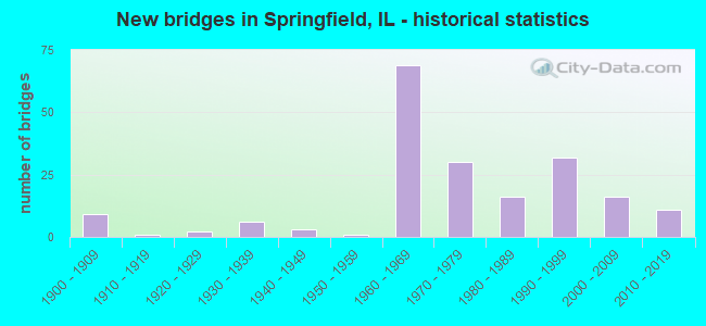
- New bridges - historical statistics
- 91900-1909
- 11910-1919
- 21920-1929
- 61930-1939
- 31940-1949
- 11950-1959
- 691960-1969
- 301970-1979
- 161980-1989
- 321990-1999
- 162000-2009
- 112010-2019

- Reconstructed bridges - Historical Statistics
- 11960-1969
- 21970-1979
- 21980-1989
- 111990-1999
- 72000-2009
- 32010-2019
- 22020-2022


- Bridge Condition - Deck
- 0.9%Excellent
- 24.1%Very good
- 41.1%Good
- 25.0%Satisfactory
- 5.4%Fair
- 3.6%Poor

- Bridge Condition - Superstructure
- 0.9%Excellent
- 25.9%Very good
- 43.8%Good
- 17.9%Satisfactory
- 7.1%Fair
- 4.5%Poor

- Bridge Condition - Substructure
- 31.3%Excellent
- 46.4%Very good
- 16.1%Good
- 4.5%Satisfactory
- 1.8%Fair
- 0.9%Poor

- Bridge Condition - Channel
- 40.7%Very good
- 33.3%Good
- 18.5%Satisfactory
- 7.4%Fair

- Bridge Condition - Culverts
- 8.7%Very good
- 52.2%Good
- 34.8%Satisfactory
- 4.3%Fair
Find on map >> Show street view
Structure Number: 846003, Location: 20FT W OUTER PK DR (Lat: 39.780886, Lng: -89.684972), Route carried "on" structure: Other road , Year Built: 1967, Status: Open, Structure Length: 1.65m (5.41ft), Average Daily Traffic: 4,000 (year 2017), Truck Traffic: 9%, Average Future Daily Traffic: 6,861 (year 2032), Design Load: HS 20, Features Intersected: JACKSONVILLE BR, Facility Carried by Structure: LAUREL ST
Minimum Vertical Clearance: 30+ m (98+ ft), Kilometerpoint: 5.069, Lanes on structure: 2, Owner: City or Municipal Highway Agency, Approaching Roadway Width: 8.2m (26.9ft), Skew: 4 degrees, Material/Design: Concrete continuous, Design/Construction: Culvert, Number Of Spans In Main Unit: 3, Length of Maximum Span: 5.4m (17.7ft), Curb or Sidewalk Widths: Left: 1.2m (3.9ft), Right: 1.2m (3.9ft), Curb-To-Curb Width: 11.2m (36.7ft), Out-to-Out Width: 14.4m (47.2ft)
Condition: Channel: Good, Culverts: Satisfactory, Operating Rating: 28.2 metric tons, Method Used To Determine Operating Rating: Load Factor (LF) rating reported by rating factor (RF) method using MS18 loading, Inventory Rating: 16.8 metric tons, Method Used To Determine Inventory Rating: Load Factor (LF) rating reported by rating factor (RF) method using MS18 loading, Structural Evaluation: Meets minimum limits, Deck Geometry: Somewhat better than minimum adequacy, Waterway Adequacy: Equal to present minimum criteria, Approach Roadway Alignment: Better than present minimum criteria, Designated Inspection Frequency: Every 24 months, Inspection Date: March 2021
Find on map >> Show street view
Structure Number: 846011, Location: PIPER GLEN (Lat: 39.693897, Lng: -89.698144), Route carried "on" structure: City street , Year Built: 2002, Status: Open, Structure Length: 2.19m (7.19ft), Average Daily Traffic: 1,600 (year 2017), Average Future Daily Traffic: 31 (year 2032), Design Load: HS 20, Features Intersected: POLECAT CREEK, Facility Carried by Structure: WENTWORTH ST
Minimum Vertical Clearance: 30+ m (98+ ft), Kilometerpoint: 0.901, Lanes on structure: 2, Owner: City or Municipal Highway Agency, Approaching Roadway Width: 8.7m (28.5ft), Material/Design: Concrete, Design/Construction: Channel Beam, Number Of Spans In Main Unit: 3, Length of Maximum Span: 7.9m (25.9ft), Curb or Sidewalk Widths: Left: 1.9m (6.2ft), Right: 1.9m (6.2ft), Curb-To-Curb Width: 8.7m (28.5ft), Out-to-Out Width: 12.6m (41.3ft)
Condition: Deck: Satisfactory, Superstructure: Satisfactory, Substructure: Good, Channel: Good, Operating Rating: 44.1 metric tons, Method Used To Determine Operating Rating: Assigned rating based on Load Factor Design (LFD) reported by rating factor (RF) using MS18 loading, Inventory Rating: 32.4 metric tons, Method Used To Determine Inventory Rating: Assigned rating based on Load Factor Design (LFD) reported by rating factor (RF) using MS18 loading, Structural Evaluation: Equal to present minimum criteria, Deck Geometry: Somewhat better than minimum adequacy, Waterway Adequacy: Better than present minimum criteria, Approach Roadway Alignment: Better than present minimum criteria, Designated Inspection Frequency: Every 24 months, Inspection Date: March 2021, Deck Structure Type: Concrete Precast Panels, Wearing Surface/Protective System: Wearing Surface: Bituminous, Membrane: Built-up
Find on map >> Show street view
Structure Number: 846014, Location: 20FT W OUTER PK DR. (Lat: 39.778372, Lng: -89.684589), Route carried "on" structure: City street , Year Built: 1990, Status: Open, Structure Length: 1.71m (5.61ft), Average Daily Traffic: 100 (year 2020), Average Future Daily Traffic: 117 (year 2032), Design Load: HS 20, Features Intersected: JACKSONVILLE BRANCH, Facility Carried by Structure: BRIDGE TERRACE
Minimum Vertical Clearance: 30+ m (98+ ft), Kilometerpoint: 0.145, Lanes on structure: 2, Owner: City or Municipal Highway Agency, Approaching Roadway Width: 7.3m (24.0ft), Material/Design: Prestressed concrete, Design/Construction: Box Beam or Girders - Multiple, Number Of Spans In Main Unit: 1, Length of Maximum Span: 16.1m (52.8ft), Curb or Sidewalk Widths: Left: 0.0m, Right: 1.2m (3.9ft), Curb-To-Curb Width: 6.1m (20.0ft), Out-to-Out Width: 7.4m (24.3ft)
Condition: Deck: Good, Superstructure: Good, Substructure: Very good, Channel: Very good, Operating Rating: 44.4 metric tons, Method Used To Determine Operating Rating: Assigned rating based on Load Factor Design (LFD) reported by rating factor (RF) using MS18 loading, Inventory Rating: 32.4 metric tons, Method Used To Determine Inventory Rating: Assigned rating based on Load Factor Design (LFD) reported by rating factor (RF) using MS18 loading, Structural Evaluation: Better than present minimum criteria, Deck Geometry: Somewhat better than minimum adequacy, Waterway Adequacy: Equal to present desirable criteria, Approach Roadway Alignment: Equal to present desirable criteria, Designated Inspection Frequency: Every 48 months, Inspection Date: March 2019, Deck Structure Type: Concrete Precast Panels, Wearing Surface/Protective System: Wearing Surface: Bituminous, Membrane: Built-up
Find on map >> Show street view
Structure Number: 846015, Location: SPRINGFIELD (Lat: 39.793578, Lng: -89.729683), Route carried "on" structure: Other road , Year Built: 2010, Status: Open, Structure Length: 1.07m (3.51ft), Average Daily Traffic: 1,300 (year 2017), Truck Traffic: 8%, Average Future Daily Traffic: 1,072 (year 2032), Design Load: HS 20, Features Intersected: SPRING CREEK, Facility Carried by Structure: MEADOW BROOK RD
Minimum Vertical Clearance: 30+ m (98+ ft), Kilometerpoint: 0.837, Lanes on structure: 2, Owner: City or Municipal Highway Agency, Approaching Roadway Width: 13.4m (44.0ft), Material/Design: Concrete, Design/Construction: Arch - Deck, Number Of Spans In Main Unit: 1, Length of Maximum Span: 9.8m (32.2ft), Curb or Sidewalk Widths: Left: 1.8m (5.9ft), Right: 1.8m (5.9ft), Curb-To-Curb Width: 13.4m (44.0ft), Out-to-Out Width: 17.1m (56.1ft)
Condition: Deck: Good, Superstructure: Good, Substructure: Very good, Channel: Very good, Operating Rating: 44.1 metric tons, Method Used To Determine Operating Rating: Assigned rating based on Load Factor Design (LFD) reported by rating factor (RF) using MS18 loading, Inventory Rating: 32.4 metric tons, Method Used To Determine Inventory Rating: Assigned rating based on Load Factor Design (LFD) reported by rating factor (RF) using MS18 loading, Structural Evaluation: Better than present minimum criteria, Deck Geometry: Equal to present desirable criteria, Waterway Adequacy: Equal to present desirable criteria, Approach Roadway Alignment: Equal to present desirable criteria, Designated Inspection Frequency: Every 48 months, Inspection Date: March 2021, Wearing Surface/Protective System: Wearing Surface: Bituminous
Find on map >> Show street view
Structure Number: 846017, Location: BRUNS LANE (Lat: 39.821272, Lng: -89.687222), Route carried "on" structure: Other road , Year Built: 2008, Status: Open, Structure Length: 4.69m (15.39ft), Average Daily Traffic: 3,100 (year 2020), Truck Traffic: 3%, Average Future Daily Traffic: 4,342 (year 2032), Design Load: HS 20, Features Intersected: SPRING CREEK, Facility Carried by Structure: BRUNS LANE
Minimum Vertical Clearance: 30+ m (98+ ft), Kilometerpoint: 0.451, Lanes on structure: 4, Base Highway Network: Yes, Owner: City or Municipal Highway Agency, Approaching Roadway Width: 13.4m (44.0ft), Material/Design: Steel continuous, Design/Construction: Stringer/Multi-beam, Number Of Spans In Main Unit: 3, Length of Maximum Span: 17.2m (56.4ft), Curb-To-Curb Width: 15.5m (50.9ft), Out-to-Out Width: 19.2m (63.0ft)
Condition: Deck: Very good, Superstructure: Very good, Substructure: Very good, Channel: Very good, Operating Rating: 44.1 metric tons, Method Used To Determine Operating Rating: Assigned rating based on Load Factor Design (LFD) reported by rating factor (RF) using MS18 loading, Inventory Rating: 32.4 metric tons, Method Used To Determine Inventory Rating: Assigned rating based on Load Factor Design (LFD) reported by rating factor (RF) using MS18 loading, Structural Evaluation: Equal to present desirable criteria, Deck Geometry: Meets minimum limits, Waterway Adequacy: Equal to present desirable criteria, Approach Roadway Alignment: Equal to present desirable criteria, Designated Inspection Frequency: Every 48 months, Inspection Date: March 2020, Deck Structure Type: Concrete Cast-file-Place
Find on map >> Show street view
Structure Number: 846019, Location: .25 mi N of Wabash (Lat: 39.768300, Lng: -89.686914), Route carried "on" structure: Other road , Year Built: 2014, Status: Open, Structure Length: 3.88m (12.73ft), Average Daily Traffic: 18,800 (year 2012), Truck Traffic: 3%, Average Future Daily Traffic: 18,800 (year 2032), Design Load: HS 25 or greater, Features Intersected: JACKSONVILLE BR, Facility Carried by Structure: CHATHAM ROAD
Minimum Vertical Clearance: 30+ m (98+ ft), Kilometerpoint: 6.341, Lanes on structure: 4, Base Highway Network: Yes, Owner: City or Municipal Highway Agency, Approaching Roadway Width: 14.6m (47.9ft), Material/Design: Prestressed concrete, Design/Construction: Box Beam or Girders - Multiple, Number Of Spans In Main Unit: 3, Length of Maximum Span: 15.8m (51.8ft), Curb-To-Curb Width: 17.1m (56.1ft), Out-to-Out Width: 22.9m (75.1ft)
Condition: Deck: Good, Superstructure: Good, Substructure: Very good, Channel: Very good, Operating Rating: 42.1 metric tons, Method Used To Determine Operating Rating: Assigned ratings based on Load and Resistance Factor Design (LRFD) reported by rating factor (RF) using HL93 loadings, Inventory Rating: 32.4 metric tons, Method Used To Determine Inventory Rating: Assigned ratings based on Load and Resistance Factor Design (LRFD) reported by rating factor (RF) using HL93 loadings, Structural Evaluation: Better than present minimum criteria, Deck Geometry: Somewhat better than minimum adequacy, Waterway Adequacy: Equal to present desirable criteria, Approach Roadway Alignment: Equal to present desirable criteria, Designated Inspection Frequency: Every 48 months, Inspection Date: March 2020, Deck Structure Type: Concrete Precast Panels, Wearing Surface/Protective System: Wearing Surface: Integral Concrete, Membrane: Epoxy, Deck Protection: Epoxy Coated Reinforcing
Find on map >> Show street view
Structure Number: 84602, Location: 0.29 mi E Chatham Rd (Lat: 39.790892, Lng: -89.681578), Route carried "on" structure: Other road , Year Built: 2015, Status: Open, Structure Length: 1.52m (4.99ft), Average Daily Traffic: 1,300 (year 2012), Truck Traffic: 3%, Average Future Daily Traffic: 1,876 (year 2032), Design Load: HS 25 or greater, Features Intersected: OLD JACKSONVILLE BR, Facility Carried by Structure: FAU 7987
Minimum Vertical Clearance: 30+ m (98+ ft), Kilometerpoint: 0.467, Lanes on structure: 2, Owner: City or Municipal Highway Agency, Approaching Roadway Width: 8.2m (26.9ft), Material/Design: Prestressed concrete, Design/Construction: Box Beam or Girders - Multiple, Number Of Spans In Main Unit: 1, Length of Maximum Span: 14.6m (47.9ft), Curb or Sidewalk Widths: Left: 1.6m (5.2ft), Right: 1.6m (5.2ft), Curb-To-Curb Width: 8.2m (26.9ft), Out-to-Out Width: 12.2m (40.0ft)
Condition: Deck: Very good, Superstructure: Very good, Substructure: Very good, Channel: Very good, Operating Rating: 42.1 metric tons, Method Used To Determine Operating Rating: Assigned ratings based on Load and Resistance Factor Design (LRFD) reported by rating factor (RF) using HL93 loadings, Inventory Rating: 32.4 metric tons, Method Used To Determine Inventory Rating: Assigned ratings based on Load and Resistance Factor Design (LRFD) reported by rating factor (RF) using HL93 loadings, Structural Evaluation: Equal to present desirable criteria, Deck Geometry: Meets minimum limits, Waterway Adequacy: Equal to present desirable criteria, Approach Roadway Alignment: Equal to present desirable criteria, Designated Inspection Frequency: Every 48 months, Inspection Date: March 2018, Deck Structure Type: Concrete Precast Panels, Wearing Surface/Protective System: Wearing Surface: Integral Concrete, Deck Protection: Epoxy Coated Reinforcing
Find on map >> Show street view
Structure Number: 846021, Location: Washington Pk Splwy (Lat: 39.790550, Lng: -89.681258), Route carried "on" structure: County highway , Year Built: 2017, Status: Open, Structure Length: 1.35m (4.43ft), Average Daily Traffic: 550 (year 2012), Truck Traffic: 9%, Average Future Daily Traffic: 649 (year 2038), Design Load: HS 25 or greater, Features Intersected: Jacksonville Branch, Facility Carried by Structure: TR-1028D (N Ring R
Minimum Vertical Clearance: 30+ m (98+ ft), Kilometerpoint: 1.577, Lanes on structure: 1, Owner: Local Park, Forest, or Reservation Agency, Approaching Roadway Width: 6.7m (22.0ft), Material/Design: Concrete, Design/Construction: Arch - Deck, Number Of Spans In Main Unit: 1, Length of Maximum Span: 13.2m (43.3ft), Curb or Sidewalk Widths: Left: 1.5m (4.9ft), Right: 1.5m (4.9ft), Curb-To-Curb Width: 5.7m (18.7ft), Out-to-Out Width: 9.2m (30.2ft)
Condition: Deck: Very good, Superstructure: Very good, Substructure: Very good, Channel: Very good, Operating Rating: 42.1 metric tons, Method Used To Determine Operating Rating: Assigned ratings based on Load and Resistance Factor Design (LRFD) reported by rating factor (RF) using HL93 loadings, Inventory Rating: 32.4 metric tons, Method Used To Determine Inventory Rating: Assigned ratings based on Load and Resistance Factor Design (LRFD) reported by rating factor (RF) using HL93 loadings, Structural Evaluation: Equal to present desirable criteria, Deck Geometry: High priority of replacement, Waterway Adequacy: Equal to present desirable criteria, Approach Roadway Alignment: Equal to present desirable criteria, Designated Inspection Frequency: Every 48 months, Inspection Date: September 2019, Wearing Surface/Protective System: Wearing Surface: Integral Concrete
Find on map >> Show street view
Structure Number: 846022, Location: Wash Pk Lagoon S end (Lat: 39.788047, Lng: -89.682447), Route carried "on" structure: County highway , Year Built: 2017, Status: Open, Structure Length: 1.35m (4.43ft), Average Daily Traffic: 1,200 (year 2012), Truck Traffic: 2%, Average Future Daily Traffic: 1,416 (year 2038), Design Load: HS 25 or greater, Features Intersected: Jacksonville Branch, Facility Carried by Structure: TR-1028A (S Ring R
Minimum Vertical Clearance: 30+ m (98+ ft), Kilometerpoint: 0.547, Lanes on structure: 1, Owner: Local Park, Forest, or Reservation Agency, Approaching Roadway Width: 6.7m (22.0ft), Material/Design: Concrete, Design/Construction: Arch - Deck, Number Of Spans In Main Unit: 1, Length of Maximum Span: 13.2m (43.3ft), Curb or Sidewalk Widths: Left: 1.5m (4.9ft), Right: 1.5m (4.9ft), Curb-To-Curb Width: 5.7m (18.7ft)
Condition: Deck: Very good, Superstructure: Very good, Substructure: Very good, Channel: Very good, Operating Rating: 42.1 metric tons, Method Used To Determine Operating Rating: Assigned ratings based on Load and Resistance Factor Design (LRFD) reported by rating factor (RF) using HL93 loadings, Inventory Rating: 32.4 metric tons, Method Used To Determine Inventory Rating: Assigned ratings based on Load and Resistance Factor Design (LRFD) reported by rating factor (RF) using HL93 loadings, Structural Evaluation: Equal to present desirable criteria, Deck Geometry: High priority of replacement, Waterway Adequacy: Equal to present desirable criteria, Approach Roadway Alignment: Equal to present desirable criteria, Designated Inspection Frequency: Every 48 months, Inspection Date: September 2019, Wearing Surface/Protective System: Wearing Surface: Integral Concrete
Find on map >> Show street view
Structure Number: 848001, Location: 100 FEET NO.FAU7977 (Lat: 39.801744, Lng: -89.715736), Route carried "on" structure: City street , Year Built: 1984, Status: Open, Structure Length: 1.00m (3.28ft), Average Daily Traffic: 1,100 (year 2017), Truck Traffic: 12%, Average Future Daily Traffic: 1,822 (year 2032), Design Load: HS 20, Features Intersected: SPRING CREEK, Facility Carried by Structure: KOKE MILL ROAD 729
Minimum Vertical Clearance: 30+ m (98+ ft), Kilometerpoint: 0.290, Lanes on structure: 2, Owner: City or Municipal Highway Agency, Approaching Roadway Width: 7.3m (24.0ft), Material/Design: Concrete continuous, Design/Construction: Culvert, Number Of Spans In Main Unit: 3, Length of Maximum Span: 3.3m (10.8ft), Curb-To-Curb Width: 9.3m (30.5ft), Out-to-Out Width: 12.0m (39.4ft)
Condition: Channel: Satisfactory, Culverts: Fair, Operating Rating: 63.5 metric tons, Method Used To Determine Operating Rating: Load Factor (LF) rating reported by rating factor (RF) method using MS18 loading, Inventory Rating: 37.9 metric tons, Method Used To Determine Inventory Rating: Load Factor (LF) rating reported by rating factor (RF) method using MS18 loading, Structural Evaluation: Somewhat better than minimum adequacy, Deck Geometry: Somewhat better than minimum adequacy, Waterway Adequacy: Equal to present minimum criteria, Approach Roadway Alignment: Better than present minimum criteria, Designated Inspection Frequency: Every 24 months, Inspection Date: March 2021, Deck Structure Type: Concrete Cast-file-Place, Wearing Surface/Protective System: Deck Protection: Epoxy Coated Reinforcing
Find on map >> Show street view
Structure Number: 848002, Location: 0.02MI WEST KOKEMILL (Lat: 39.801156, Lng: -89.715886), Route carried "on" structure: Other road , Year Built: 1984, Status: Open, Structure Length: 0.89m (2.92ft), Average Daily Traffic: 5,400 (year 2020), Truck Traffic: 2%, Average Future Daily Traffic: 7,933 (year 2032), Design Load: HS 20, Features Intersected: SPRING CREEK, Facility Carried by Structure: WASHINGTONFAU-7977
Minimum Vertical Clearance: 30+ m (98+ ft), Kilometerpoint: 2.012, Lanes on structure: 2, Base Highway Network: Yes, Owner: City or Municipal Highway Agency, Approaching Roadway Width: 7.3m (24.0ft), Skew: 1 degrees, Material/Design: Concrete continuous, Design/Construction: Culvert, Number Of Spans In Main Unit: 2, Length of Maximum Span: 4.3m (14.1ft), Curb-To-Curb Width: 10.5m (34.4ft), Out-to-Out Width: 13.7m (44.9ft)
Condition: Channel: Good, Culverts: Good, Operating Rating: 71.9 metric tons, Method Used To Determine Operating Rating: Load Factor (LF) rating reported by rating factor (RF) method using MS18 loading, Inventory Rating: 43.1 metric tons, Method Used To Determine Inventory Rating: Load Factor (LF) rating reported by rating factor (RF) method using MS18 loading, Structural Evaluation: Better than present minimum criteria, Deck Geometry: Meets minimum limits, Waterway Adequacy: Equal to present desirable criteria, Approach Roadway Alignment: Equal to present desirable criteria, Designated Inspection Frequency: Every 48 months, Inspection Date: March 2019, Deck Structure Type: Concrete Cast-file-Place, Wearing Surface/Protective System: Deck Protection: Epoxy Coated Reinforcing
Find on map >> Show street view
Structure Number: 848003, Location: .2 mi E Bruns Ln (Lat: 39.816103, Lng: -89.683558), Route carried "on" structure: Other road , Year Built: 1976, Status: Open, Structure Length: 0.91m (2.99ft), Average Daily Traffic: 4,400 (year 2020), Truck Traffic: 3%, Average Future Daily Traffic: 6,754 (year 2032), Design Load: HS 20, Features Intersected: STREAM, Facility Carried by Structure: NORTH GRAND
Minimum Vertical Clearance: 30+ m (98+ ft), Kilometerpoint: 0.322, Lanes on structure: 4, Base Highway Network: Yes, Owner: City or Municipal Highway Agency, Approaching Roadway Width: 9.1m (29.9ft), Material/Design: Concrete continuous, Design/Construction: Culvert, Number Of Spans In Main Unit: 3, Length of Maximum Span: 3.0m (9.8ft)
Condition: Channel: Good, Culverts: Satisfactory, Operating Rating: 44.4 metric tons, Method Used To Determine Operating Rating: Assigned rating based on Load Factor Design (LFD) reported by rating factor (RF) using MS18 loading, Inventory Rating: 32.4 metric tons, Method Used To Determine Inventory Rating: Assigned rating based on Load Factor Design (LFD) reported by rating factor (RF) using MS18 loading, Structural Evaluation: Equal to present minimum criteria, Waterway Adequacy: Equal to present desirable criteria, Approach Roadway Alignment: Equal to present desirable criteria, Designated Inspection Frequency: Every 24 months, Inspection Date: March 2020
Find on map >> Show street view
Structure Number: 848004, Location: W. WASHINGTON ST. (Lat: 39.801181, Lng: -89.726883), Route carried "on" structure: Other road , Year Built: 1990, Status: Open, Structure Length: 0.87m (2.85ft), Average Daily Traffic: 4,350 (year 2012), Truck Traffic: 2%, Average Future Daily Traffic: 4,878 (year 2032), Design Load: HS 20, Features Intersected: SPRING CREEK, Facility Carried by Structure: FAU 7977
Minimum Vertical Clearance: 30+ m (98+ ft), Kilometerpoint: 1.062, Lanes on structure: 2, Base Highway Network: Yes, Owner: City or Municipal Highway Agency, Approaching Roadway Width: 11.9m (39.0ft), Skew: 2 degrees, Material/Design: Concrete continuous, Design/Construction: Culvert, Number Of Spans In Main Unit: 2, Length of Maximum Span: 0.9m (3.0ft)
Condition: Channel: Very good, Culverts: Good, Operating Rating: 44.4 metric tons, Method Used To Determine Operating Rating: Assigned rating based on Load Factor Design (LFD) reported by rating factor (RF) using MS18 loading, Inventory Rating: 32.4 metric tons, Method Used To Determine Inventory Rating: Assigned rating based on Load Factor Design (LFD) reported by rating factor (RF) using MS18 loading, Structural Evaluation: Better than present minimum criteria, Waterway Adequacy: Equal to present desirable criteria, Approach Roadway Alignment: Equal to present desirable criteria, Designated Inspection Frequency: Every 48 months, Inspection Date: March 2019
Find on map >> Show street view
Structure Number: 848006, Location: ILES @ CHATHAM RD (Lat: 39.770881, Lng: -89.686792), Route carried "on" structure: Other road , Year Built: 1970, Status: Open, Structure Length: 1.19m (3.90ft), Average Daily Traffic: 1,450 (year 2012), Truck Traffic: 2%, Average Future Daily Traffic: 4,342 (year 2032), Design Load: HS 15, Features Intersected: STREAM, Facility Carried by Structure: ILES AVE
Minimum Vertical Clearance: 30+ m (98+ ft), Kilometerpoint: 0.016, Lanes on structure: 2, Owner: City or Municipal Highway Agency, Approaching Roadway Width: 12.3m (40.4ft), Material/Design: Concrete continuous, Design/Construction: Culvert, Number Of Spans In Main Unit: 3, Length of Maximum Span: 3.9m (12.8ft), Curb or Sidewalk Widths: Left: 1.2m (3.9ft), Right: 1.2m (3.9ft), Curb-To-Curb Width: 12.3m (40.4ft), Out-to-Out Width: 15.5m (50.9ft)
Condition: Channel: Good, Culverts: Satisfactory, Operating Rating: 40.5 metric tons, Method Used To Determine Operating Rating: Field evaluation and documented engineering judgment, Inventory Rating: 24.3 metric tons, Method Used To Determine Inventory Rating: Field evaluation and documented engineering judgment, Structural Evaluation: Equal to present minimum criteria, Deck Geometry: Better than present minimum criteria, Waterway Adequacy: Better than present minimum criteria, Approach Roadway Alignment: Better than present minimum criteria, Designated Inspection Frequency: Every 24 months, Inspection Date: October 2021, Deck Structure Type: Concrete Cast-file-Place
Find on map >> Show street view
Structure Number: 848009, Location: 0.5 M N 125/97 (Lat: 39.811531, Lng: -89.677836), Route carried "on" structure: Other road , Year Built: 2007, Status: Open, Structure Length: 1.31m (4.30ft), Average Daily Traffic: 1,350 (year 2012), Truck Traffic: 3%, Average Future Daily Traffic: 1,501 (year 2032), Design Load: HS 20, Features Intersected: DRAINAGE DITCH, Facility Carried by Structure: AMOS AV
Minimum Vertical Clearance: 30+ m (98+ ft), Kilometerpoint: 0.499, Lanes on structure: 2, Owner: City or Municipal Highway Agency, Approaching Roadway Width: 6.7m (22.0ft), Material/Design: Concrete continuous, Design/Construction: Culvert, Number Of Spans In Main Unit: 3, Length of Maximum Span: 4.9m (16.1ft), Curb or Sidewalk Widths: Left: 1.5m (4.9ft), Right: 1.5m (4.9ft), Curb-To-Curb Width: 8.2m (26.9ft), Out-to-Out Width: 12.9m (42.3ft)
Condition: Channel: Good, Culverts: Very good, Operating Rating: 44.1 metric tons, Method Used To Determine Operating Rating: Assigned rating based on Load Factor Design (LFD) reported by rating factor (RF) using MS18 loading, Inventory Rating: 32.4 metric tons, Method Used To Determine Inventory Rating: Assigned rating based on Load Factor Design (LFD) reported by rating factor (RF) using MS18 loading, Structural Evaluation: Equal to present desirable criteria, Deck Geometry: Meets minimum limits, Waterway Adequacy: Equal to present desirable criteria, Approach Roadway Alignment: Equal to present desirable criteria, Designated Inspection Frequency: Every 48 months, Inspection Date: March 2018
Find on map >> Show street view
Structure Number: 849916, Location: SE PART OF SPFLD (Lat: 39.726817, Lng: -89.597847), Route carried "on" structure: Other road , Year Built: 1933, Status: Open, Structure Length: 42.61m (139.80ft), Average Daily Traffic: 1,850 (year 2020), Truck Traffic: 5%, Average Future Daily Traffic: 2,198 (year 2032), Features Intersected: LAKE SPFLD, Facility Carried by Structure: FAU 8003 LONG BAY
Minimum Vertical Clearance: 30+ m (98+ ft), Kilometerpoint: 0.531, Lanes on structure: 2, Owner: City or Municipal Highway Agency, Approaching Roadway Width: 5.8m (19.0ft), Material/Design: Concrete, Design/Construction: Girder and Floorbeam System, Number Of Spans In Main Unit: 11, Number Of Approach Spans: 10, Length of Maximum Span: 30.5m (100.1ft), Curb or Sidewalk Widths: Left: 1.5m (4.9ft), Right: 1.5m (4.9ft), Curb-To-Curb Width: 6.7m (22.0ft), Out-to-Out Width: 11.3m (37.1ft)
Condition: Deck: Good, Superstructure: Good, Substructure: Good, Channel: Very good, Operating Rating: 26.9 metric tons, Method Used To Determine Operating Rating: Load Factor (LF) rating reported by rating factor (RF) method using MS18 loading, Inventory Rating: 16.5 metric tons, Method Used To Determine Inventory Rating: Load Factor (LF) rating reported by rating factor (RF) method using MS18 loading, Structural Evaluation: Meets minimum limits, Deck Geometry: High priority of corrective action, Waterway Adequacy: Superior to present desirable criteria, Approach Roadway Alignment: Equal to present minimum criteria, Length Of Structure Improvement: 42.61m (139.80ft), Designated Inspection Frequency: Every 24 months, Underwater Inspection Frequency: Every 60 months, Inspection Date: September 2020, Underwater Inspection Date: September 2016, Bridge Improvement Cost: $4,576,000, Roadway Improvement Cost: $458,000, Total Project Cost: $6,864,000, Deck Structure Type: Concrete Cast-file-Place, Wearing Surface/Protective System: Wearing Surface: Epoxy Overlay
Find on map >> Show street view
Structure Number: 849941, Location: .5M E STEV DR@L SPFD (Lat: 39.759553, Lng: -89.600928), Route carried "on" structure: Other road , Year Built: 1992, Status: Open, Structure Length: 10.74m (35.24ft), Average Daily Traffic: 10,900 (year 2012), Truck Traffic: 5%, Average Future Daily Traffic: 12,971 (year 2032), Design Load: HS 20, Features Intersected: SUGAR CREEK, Facility Carried by Structure: E LAKE DR / FAU 79
Minimum Vertical Clearance: 30+ m (98+ ft), Kilometerpoint: 0.724, Lanes on structure: 2, Base Highway Network: Yes, Owner: City or Municipal Highway Agency, Approaching Roadway Width: 9.1m (29.9ft), Material/Design: Prestressed concrete, Design/Construction: Stringer/Multi-beam, Number Of Spans In Main Unit: 5, Length of Maximum Span: 27.4m (89.9ft), Curb-To-Curb Width: 9.1m (29.9ft), Out-to-Out Width: 10.1m (33.1ft)
Condition: Deck: Very good, Superstructure: Good, Substructure: Very good, Channel: Very good, Operating Rating: 44.1 metric tons, Method Used To Determine Operating Rating: Assigned rating based on Load Factor Design (LFD) reported by rating factor (RF) using MS18 loading, Inventory Rating: 32.4 metric tons, Method Used To Determine Inventory Rating: Assigned rating based on Load Factor Design (LFD) reported by rating factor (RF) using MS18 loading, Structural Evaluation: Better than present minimum criteria, Deck Geometry: Meets minimum limits, Waterway Adequacy: Equal to present desirable criteria, Approach Roadway Alignment: Better than present minimum criteria, Designated Inspection Frequency: Every 48 months, Inspection Date: June 2019, Deck Structure Type: Concrete Cast-file-Place
Find on map >> Show street view
Structure Number: 849944, Location: STANFORD AVE (Lat: 39.766039, Lng: -89.655225), Route carried "on" structure: Other road , Year Built: 1999, Status: Open, Structure Length: 6.73m (22.08ft), Average Daily Traffic: 21,700 (year 2021), Truck Traffic: 3%, Average Future Daily Traffic: 26,371 (year 2032), Design Load: HS 20, Features Intersected: NS RR & UP RR, Facility Carried by Structure: STANFORD AVE
Minimum Vertical Clearance: 30+ m (98+ ft), Kilometerpoint: 1.127, Lanes on structure: 6, Base Highway Network: Yes, Owner: City or Municipal Highway Agency, Approaching Roadway Width: 26.2m (86.0ft), Skew: 2 degrees, Material/Design: Steel continuous, Design/Construction: Stringer/Multi-beam, Number Of Spans In Main Unit: 3, Length of Maximum Span: 28.7m (94.2ft), Curb or Sidewalk Widths: Left: 1.5m (4.9ft), Right: 0.0m, Curb-To-Curb Width: 26.2m (86.0ft), Out-to-Out Width: 28.5m (93.5ft)
Condition: Deck: Very good, Superstructure: Very good, Substructure: Very good, Operating Rating: 44.1 metric tons, Method Used To Determine Operating Rating: Assigned rating based on Load Factor Design (LFD) reported by rating factor (RF) using MS18 loading, Inventory Rating: 32.4 metric tons, Method Used To Determine Inventory Rating: Assigned rating based on Load Factor Design (LFD) reported by rating factor (RF) using MS18 loading, Structural Evaluation: Equal to present desirable criteria, Deck Geometry: Equal to present minimum criteria, Underclear: Equal to present desirable criteria, Approach Roadway Alignment: Equal to present desirable criteria, Designated Inspection Frequency: Every 48 months, Inspection Date: March 2019, Deck Structure Type: Concrete Cast-file-Place
Find on map >> Show street view
Structure Number: 840007, Location: .75M E 6TH ST (Lat: 39.744719, Lng: -89.630400), Route carried "under" structure: Interstate 55, Year Built: 1962, Structure Length: 0. m, Average Daily Traffic: 53,900 (year 2021), Truck Traffic: 23%, Features Intersected: I-55 / I-72 / US 36, Facility Carried by Structure: ILLINOIS CENTRAL R
Minimum Vertical Clearance: 4.93m (16.17ft), Kilometerpoint: 149.102, Lanes under structure: 4, Material/Design: Steel, Design/Construction: Girder and Floorbeam System, Length of Maximum Span: 18.0m (59.1ft)
Find on map >> Show street view
Structure Number: 840008, Location: .1M S STEVENSON INT (Lat: 39.756964, Lng: -89.606114), Route carried "under" structure: Interstate 55, Year Built: 1963, Structure Length: 0. m, Average Daily Traffic: 53,900 (year 2021), Truck Traffic: 23%, Features Intersected: I-55 / I-72 / US 36, Facility Carried by Structure: CWLP Private Road
Minimum Vertical Clearance: 4.95m (16.24ft), Kilometerpoint: 151.644, Lanes under structure: 4, Material/Design: Steel, Design/Construction: Girder and Floorbeam System, Length of Maximum Span: 26.5m (86.9ft)
Find on map >> Show street view
Structure Number: 840011, Location: I-55/IL 29 INT E SPI (Lat: 39.786228, Lng: -89.599553), Route carried "under" structure: State highway 29, Year Built: 1963, Structure Length: 0. m, Average Daily Traffic: 15,700 (year 2021), Truck Traffic: 7%, Features Intersected: IL 29 / SO GRAND AVE, Facility Carried by Structure: I-55 (NB)/ I-72 (E
Minimum Vertical Clearance: 4.55m (14.93ft), Kilometerpoint: 65.386, Lanes on structure: 2, Lanes under structure: 4, Material/Design: Steel continuous, Design/Construction: Stringer/Multi-beam, Length of Maximum Span: 24.4m (80.1ft)
Find on map >> Show street view
Structure Number: 840012, Location: I-55/IL29 INT E SPI (Lat: 39.786228, Lng: -89.599553), Route carried "under" structure: State highway 29, Year Built: 1963, Structure Length: 0. m, Average Daily Traffic: 15,700 (year 2021), Truck Traffic: 7%, Features Intersected: IL 29 / SO GRAND AVE, Facility Carried by Structure: I-55 (SB)/ I-72 (W
Minimum Vertical Clearance: 4.52m (14.83ft), Kilometerpoint: 65.386, Lanes on structure: 2, Lanes under structure: 6, Material/Design: Steel continuous, Design/Construction: Stringer/Multi-beam, Length of Maximum Span: 24.4m (80.1ft)
Find on map >> Show street view
Structure Number: 840013, Location: .3M S SANGAMON AV (Lat: 39.827567, Lng: -89.592656), Route carried "under" structure: Interstate 55, Year Built: 1962, Structure Length: 0. m, Average Daily Traffic: 37,800 (year 2021), Truck Traffic: 28%, Features Intersected: I-55, Facility Carried by Structure: NORFOLK SOUTHERN R
Minimum Vertical Clearance: 4.98m (16.34ft), Kilometerpoint: 159.562, Lanes under structure: 6, Material/Design: Steel, Design/Construction: Girder and Floorbeam System, Length of Maximum Span: 24.7m (81.0ft)
Find on map >> Show street view
Structure Number: 840014, Location: I-55/IL54 INT NE SPI (Lat: 39.831536, Lng: -89.593281), Route carried "under" structure: Other road , Year Built: 1963, Structure Length: 0. m, Average Daily Traffic: 17,700 (year 2021), Truck Traffic: 6%, Features Intersected: SANGAMON AVE / IL 54, Facility Carried by Structure: I-55 (SB)
Minimum Vertical Clearance: 5.13m (16.83ft), Kilometerpoint: 3.717, Lanes on structure: 3, Lanes under structure: 6, Material/Design: Steel continuous, Design/Construction: Stringer/Multi-beam, Length of Maximum Span: 22.3m (73.2ft)
Find on map >> Show street view
Structure Number: 840015, Location: I-55/IL54 INT NE SPI (Lat: 39.831547, Lng: -89.592967), Route carried "under" structure: State highway 54, Year Built: 1963, Structure Length: 0. m, Average Daily Traffic: 10,700 (year 2021), Truck Traffic: 8%, Features Intersected: SANGAMON AVE / IL 54, Facility Carried by Structure: I-55 (NB)
Minimum Vertical Clearance: 5.31m (17.42ft), Kilometerpoint: 0.016, Lanes on structure: 2, Lanes under structure: 6, Material/Design: Steel continuous, Design/Construction: Stringer/Multi-beam, Length of Maximum Span: 22.3m (73.2ft)
Find on map >> Show street view
Structure Number: 840028, Location: .25M S I-72 (Lat: 39.738881, Lng: -89.642544), Route carried "under" structure: Interstate 55, Year Built: 1963, Structure Length: 0. m, Average Daily Traffic: 46,300 (year 2021), Truck Traffic: 20%, Features Intersected: I-55 (SB)
Minimum Vertical Clearance: 4.98m (16.34ft), Kilometerpoint: 147.573, Lanes on structure: 2, Lanes under structure: 2, Material/Design: Steel continuous, Design/Construction: Stringer/Multi-beam, Length of Maximum Span: 34.7m (113.8ft)
Find on map >> Show street view
Structure Number: 840032, Location: 2400 S 5TH - SPFLD (Lat: 39.773528, Lng: -89.649986), Route carried "under" structure: Business Interstate 55, Year Built: 1961, Structure Length: 0. m, Average Daily Traffic: 11,400 (year 2021), Truck Traffic: 4%, Features Intersected: BUS 55 / 5TH ST., Facility Carried by Structure: NORFOLK SOUTHERN R
Minimum Vertical Clearance: 4.29m (14.07ft), Kilometerpoint: 4.297, Lanes under structure: 4, Material/Design: Steel, Length of Maximum Span: 25.8m (84.6ft)
Find on map >> Show street view
Structure Number: 840033, Location: S 5TH&STANFORD-SPFLD (Lat: 39.766169, Lng: -89.648822), Route carried "under" structure: Business Interstate 55, Year Built: 1962, Structure Length: 0. m, Average Daily Traffic: 12,600 (year 2021), Truck Traffic: 3%, Features Intersected: BUS 55 SB / 5TH ST., Facility Carried by Structure: ILLINOIS CENTRAL R
Minimum Vertical Clearance: 4.60m (15.09ft), Kilometerpoint: 3.460, Lanes under structure: 3, Material/Design: Steel, Length of Maximum Span: 22.2m (72.8ft)
Find on map >> Show street view
Structure Number: 840037, Location: .45M E 6TH ST. (Lat: 39.743361, Lng: -89.635725), Route carried "under" structure: Interstate 55, Year Built: 1997, Structure Length: 0. m, Average Daily Traffic: 53,900 (year 2021), Truck Traffic: 23%, Features Intersected: I-55 / I-72 / US 36, Facility Carried by Structure: 11TH STREET
Minimum Vertical Clearance: 5.11m (16.77ft), Kilometerpoint: 148.635, Lanes on structure: 4, Lanes under structure: 4, Material/Design: Steel continuous, Design/Construction: Stringer/Multi-beam, Length of Maximum Span: 54.2m (177.8ft)
Find on map >> Show street view
Structure Number: 840037, Location: .45M E 6TH ST. (Lat: 39.743433, Lng: -89.635769), Route carried "under" structure: Interstate 72, Year Built: 1997, Structure Length: 0. m, Average Daily Traffic: 40,500 (year 2021), Truck Traffic: 11%, Features Intersected: I-55 / I-72 / US 36, Facility Carried by Structure: 11TH STREET
Minimum Vertical Clearance: 5.11m (16.77ft), Kilometerpoint: 158.532, Lanes on structure: 4, Lanes under structure: 4, Material/Design: Steel continuous, Design/Construction: Stringer/Multi-beam, Length of Maximum Span: 54.2m (177.8ft)
Find on map >> Show street view
Structure Number: 840049, Location: .07MI E OF 18TH ST. (Lat: 39.794608, Lng: -89.629767), Route carried "under" structure: Other road , Year Built: 1933, Structure Length: 0. m, Average Daily Traffic: 7,000 (year 2017), Truck Traffic: 6%, Features Intersected: FAU 7985, Facility Carried by Structure: IC&G RR
Minimum Vertical Clearance: 4.27m (14.01ft), Kilometerpoint: 1.191, Lanes under structure: 4, Material/Design: Steel, Design/Construction: Girder and Floorbeam System, Length of Maximum Span: 16.2m (53.1ft)
Find on map >> Show street view
Structure Number: 84005, Location: CLEAR LK AVE E SPFLD (Lat: 39.801781, Lng: -89.595075), Route carried "under" structure: Interstate 55, Year Built: 1963, Structure Length: 0. m, Average Daily Traffic: 37,800 (year 2021), Truck Traffic: 28%, Features Intersected: I-55, Facility Carried by Structure: CLEAR LAKE AVE (EB
Minimum Vertical Clearance: 5.66m (18.57ft), Kilometerpoint: 156.762, Lanes on structure: 2, Lanes under structure: 6, Material/Design: Steel continuous, Design/Construction: Stringer/Multi-beam, Length of Maximum Span: 26.5m (86.9ft)
Find on map >> Show street view
Structure Number: 840051, Location: I-55-CLR LK - E SPFD (Lat: 39.801958, Lng: -89.595022), Route carried "under" structure: Interstate 55, Year Built: 1963, Structure Length: 0. m, Average Daily Traffic: 37,800 (year 2021), Truck Traffic: 28%, Features Intersected: I-55, Facility Carried by Structure: CLEAR LAKE/ I-72(W
Minimum Vertical Clearance: 5.26m (17.26ft), Kilometerpoint: 156.778, Lanes on structure: 2, Lanes under structure: 6, Material/Design: Steel continuous, Design/Construction: Stringer/Multi-beam, Length of Maximum Span: 26.5m (86.9ft)
Find on map >> Show street view
Structure Number: 840076, Location: S EDGE SPRINGFIELD (Lat: 39.742956, Lng: -89.644300), Route carried "under" structure: Business Interstate 55, Year Built: 1963, Structure Length: 0. m, Average Daily Traffic: 21,400 (year 2021), Truck Traffic: 4%, Features Intersected: 6TH ST / BUS 55, Facility Carried by Structure: I-72 / US 36 (WB)
Minimum Vertical Clearance: 4.42m (14.50ft), Kilometerpoint: 0.966, Lanes on structure: 2, Lanes under structure: 4, Material/Design: Steel continuous, Design/Construction: Stringer/Multi-beam, Length of Maximum Span: 13.2m (43.3ft)
Find on map >> Show street view
Structure Number: 840077, Location: S EDGE SPRINGFIELD (Lat: 39.742586, Lng: -89.644300), Route carried "under" structure: Business Interstate 55, Year Built: 1963, Structure Length: 0. m, Average Daily Traffic: 21,400 (year 2021), Truck Traffic: 4%, Features Intersected: 6TH ST / BUS 55, Facility Carried by Structure: I-72 / US 36 (EB)
Minimum Vertical Clearance: 4.39m (14.40ft), Kilometerpoint: 0.933, Lanes on structure: 2, Lanes under structure: 5, Material/Design: Steel continuous, Design/Construction: Stringer/Multi-beam, Length of Maximum Span: 19.2m (63.0ft)
Find on map >> Show street view
Structure Number: 840078, Location: .25M E 6TH ST. (Lat: 39.741989, Lng: -89.639439), Route carried "under" structure: Interstate 55, Year Built: 1962, Structure Length: 0. m, Average Daily Traffic: 46,300 (year 2021), Truck Traffic: 20%, Features Intersected: I-55 (SB), Facility Carried by Structure: I-72 / US 36 (EB)
Minimum Vertical Clearance: 5.00m (16.40ft), Kilometerpoint: 148.088, Lanes on structure: 2, Lanes under structure: 2, Material/Design: Steel continuous, Design/Construction: Stringer/Multi-beam, Length of Maximum Span: 46.6m (152.9ft)
Find on map >> Show street view
Structure Number: 840081, Location: 1.8M S LK SPFLD BRDG (Lat: 39.669931, Lng: -89.647369), Route carried "under" structure: Interstate 55, Year Built: 1969, Structure Length: 0. m, Average Daily Traffic: 35,600 (year 2021), Truck Traffic: 25%, Features Intersected: I-55/ PALM ROAD, Facility Carried by Structure: NEW CITY RD / CH 4
Minimum Vertical Clearance: 4.93m (16.17ft), Kilometerpoint: 139.961, Lanes on structure: 2, Lanes under structure: 8, Material/Design: Steel continuous, Design/Construction: Stringer/Multi-beam, Length of Maximum Span: 30.7m (100.7ft)
Find on map >> Show street view
Structure Number: 840081, Location: 1.8M S LK SPFLD BRDG (Lat: 39.669919, Lng: -89.648053), Route carried "under" structure: Other road , Year Built: 1969, Structure Length: 0. m, Average Daily Traffic: 1,850 (year 2021), Truck Traffic: 4%, Features Intersected: I-55/ PALM ROAD, Facility Carried by Structure: NEW CITY RD / CH 4
Minimum Vertical Clearance: 4.88m (16.01ft), Kilometerpoint: 0.418, Lanes on structure: 2, Lanes under structure: 2, Material/Design: Steel continuous, Design/Construction: Stringer/Multi-beam, Length of Maximum Span: 30.7m (100.7ft)
Find on map >> Show street view
Structure Number: 840082, Location: SE EDGE SPFLD (Lat: 39.758131, Lng: -89.605708), Route carried "under" structure: Interstate 55, Year Built: 1963, Structure Length: 0. m, Average Daily Traffic: 53,900 (year 2021), Truck Traffic: 23%, Features Intersected: I-55 / I-72 / US 36, Facility Carried by Structure: STEVENSON DR (EB)
Minimum Vertical Clearance: 5.33m (17.49ft), Kilometerpoint: 151.789, Lanes on structure: 2, Lanes under structure: 6, Material/Design: Steel continuous, Design/Construction: Stringer/Multi-beam, Length of Maximum Span: 27.0m (88.6ft)
Find on map >> Show street view
Structure Number: 840083, Location: SE EDGE SPFLD (Lat: 39.758389, Lng: -89.605650), Route carried "under" structure: Interstate 55, Year Built: 1963, Structure Length: 0. m, Average Daily Traffic: 52,300 (year 2021), Truck Traffic: 25%, Features Intersected: I-55 / I-72 / US 36, Facility Carried by Structure: STEVENSON DR (WB)
Minimum Vertical Clearance: 5.31m (17.42ft), Kilometerpoint: 151.821, Lanes on structure: 2, Lanes under structure: 6, Material/Design: Steel continuous, Design/Construction: Stringer/Multi-beam, Length of Maximum Span: 26.9m (88.3ft)
Find on map >> Show street view
Structure Number: 840092, Location: .8M SW STEVENSON INT (Lat: 39.749731, Lng: -89.616411), Route carried "under" structure: Interstate 55, Year Built: 1963, Structure Length: 0. m, Average Daily Traffic: 53,900 (year 2021), Truck Traffic: 23%, Features Intersected: I-55 / I-72 / US 36, Facility Carried by Structure: W LAKE SHORE DR
Minimum Vertical Clearance: 4.90m (16.08ft), Kilometerpoint: 150.437, Lanes on structure: 2, Lanes under structure: 4, Material/Design: Steel continuous, Design/Construction: Stringer/Multi-beam, Length of Maximum Span: 20.8m (68.2ft)
Find on map >> Show street view
Structure Number: 840099, Location: 1M S I-72/US 36 (Lat: 39.728275, Lng: -89.643986), Route carried "under" structure: Interstate 55, Year Built: 1968, Structure Length: 0. m, Average Daily Traffic: 46,300 (year 2021), Truck Traffic: 20%, Features Intersected: I-55, Facility Carried by Structure: SOUTHWIND RD
Minimum Vertical Clearance: 5.21m (17.09ft), Kilometerpoint: 146.575, Lanes on structure: 2, Lanes under structure: 6, Material/Design: Steel continuous, Design/Construction: Stringer/Multi-beam, Length of Maximum Span: 21.5m (70.5ft)
Find on map >> Show street view
Structure Number: 840101, Location: 1.1M N SANGAMON AVE (Lat: 39.845792, Lng: -89.594097), Route carried "under" structure: Interstate 55, Year Built: 1963, Structure Length: 0. m, Average Daily Traffic: 27,300 (year 2021), Truck Traffic: 34%, Features Intersected: I-55, Facility Carried by Structure: BISSELL ROAD
Minimum Vertical Clearance: 5.00m (16.40ft), Kilometerpoint: 161.670, Lanes on structure: 2, Lanes under structure: 4, Material/Design: Prestressed concrete, Design/Construction: Stringer/Multi-beam, Length of Maximum Span: 21.0m (68.9ft)
Find on map >> Show street view
Structure Number: 840102, Location: .5M S SANG AV/IL 54 (Lat: 39.825344, Lng: -89.592483), Route carried "under" structure: Interstate 55, Year Built: 1963, Structure Length: 0. m, Average Daily Traffic: 37,800 (year 2021), Truck Traffic: 28%, Features Intersected: I-55, Facility Carried by Structure: RIDGELY RD
Minimum Vertical Clearance: 4.93m (16.17ft), Kilometerpoint: 159.240, Lanes on structure: 2, Lanes under structure: 4, Material/Design: Prestressed concrete, Design/Construction: Stringer/Multi-beam, Length of Maximum Span: 20.6m (67.6ft)
Find on map >> Show street view
Structure Number: 840103, Location: .45 E FAP 75 Dirksen (Lat: 39.794603, Lng: -89.596989), Route carried "under" structure: Interstate 55, Year Built: 1963, Structure Length: 0. m, Average Daily Traffic: 53,100 (year 2021), Truck Traffic: 24%, Features Intersected: I-55 / I-72 / US 36, Facility Carried by Structure: MUN 2110E (Cook St
Minimum Vertical Clearance: 4.88m (16.01ft), Kilometerpoint: 155.941, Lanes on structure: 2, Lanes under structure: 4, Material/Design: Prestressed concrete, Design/Construction: Stringer/Multi-beam, Length of Maximum Span: 20.6m (67.6ft)
Find on map >> Show street view
Structure Number: 840104, Location: .5M W I-55/6TH ST (Lat: 39.742533, Lng: -89.653664), Route carried "under" structure: Interstate 72, Year Built: 1966, Structure Length: 0. m, Average Daily Traffic: 40,500 (year 2021), Truck Traffic: 11%, Features Intersected: I-72 / US 36, Facility Carried by Structure: S SECOND ST RD
Minimum Vertical Clearance: 4.83m (15.85ft), Kilometerpoint: 156.987, Lanes on structure: 2, Lanes under structure: 4, Material/Design: Steel continuous, Design/Construction: Stringer/Multi-beam, Length of Maximum Span: 20.8m (68.2ft)
Find on map >> Show street view
Structure Number: 840116, Location: .5M S LK SPFLD BRG (Lat: 39.686411, Lng: -89.643131), Route carried "under" structure: Interstate 55, Year Built: 1969, Structure Length: 0. m, Average Daily Traffic: 43,600 (year 2021), Truck Traffic: 22%, Features Intersected: I-55, Facility Carried by Structure: E LAKE SHORE DR
Minimum Vertical Clearance: 5.26m (17.26ft), Kilometerpoint: 141.908, Lanes on structure: 3, Lanes under structure: 6, Material/Design: Steel continuous, Design/Construction: Stringer/Multi-beam, Length of Maximum Span: 28.7m (94.2ft)
Find on map >> Show street view
Structure Number: 840117, Location: 1M N LK SPFLDBRIDGE (Lat: 39.713681, Lng: -89.643711), Route carried "under" structure: Interstate 55, Year Built: 1968, Structure Length: 0. m, Average Daily Traffic: 46,300 (year 2021), Truck Traffic: 20%, Features Intersected: I-55, Facility Carried by Structure: TORONTO RD
Minimum Vertical Clearance: 5.18m (16.99ft), Kilometerpoint: 144.966, Lanes on structure: 5, Lanes under structure: 6, Material/Design: Steel continuous, Design/Construction: Stringer/Multi-beam, Length of Maximum Span: 21.4m (70.2ft)
Find on map >> Show street view
Structure Number: 840125, Location: .5 M W IL 4 (Lat: 39.744719, Lng: -89.713367), Route carried "under" structure: Interstate 72, Year Built: 1969, Structure Length: 0. m, Average Daily Traffic: 20,200 (year 2021), Truck Traffic: 19%, Features Intersected: I-72, Facility Carried by Structure: GATEWAY WESTERN RR
Minimum Vertical Clearance: 5.11m (16.77ft), Kilometerpoint: 151.789, Lanes under structure: 4, Material/Design: Steel, Design/Construction: Girder and Floorbeam System, Length of Maximum Span: 41.1m (134.8ft)
Find on map >> Show street view
Structure Number: 840126, Location: .7M W IL 4/VETERANS (Lat: 39.746781, Lng: -89.719911), Route carried "under" structure: Interstate 72, Year Built: 1969, Structure Length: 0. m, Average Daily Traffic: 20,200 (year 2021), Truck Traffic: 19%, Features Intersected: I-72 / US 36, Facility Carried by Structure: COCKRELL LN
Minimum Vertical Clearance: 5.18m (16.99ft), Kilometerpoint: 151.162, Lanes on structure: 2, Lanes under structure: 4, Material/Design: Prestressed concrete, Design/Construction: Stringer/Multi-beam, Length of Maximum Span: 23.3m (76.4ft)
Find on map >> Show street view
Structure Number: 840133, Location: 1M N I-72 (Lat: 39.756506, Lng: -89.706436), Route carried "under" structure: State highway 4, Year Built: 1973, Structure Length: 0. m, Average Daily Traffic: 30,800 (year 2021), Truck Traffic: 4%, Features Intersected: IL 4 (VETERANS PKWY), Facility Carried by Structure: WABASH BIKE TRAIL
Minimum Vertical Clearance: 5.13m (16.83ft), Kilometerpoint: 260.610, Lanes under structure: 4, Material/Design: Steel, Length of Maximum Span: 28.0m (91.9ft)
Find on map >> Show street view
Structure Number: 840136, Location: VETERANS I-72 INTCHG (Lat: 39.742450, Lng: -89.706158), Route carried "under" structure: Interstate 72, Year Built: 1973, Structure Length: 0. m, Average Daily Traffic: 35,900 (year 2021), Truck Traffic: 12%, Features Intersected: I-72 / US 36, Facility Carried by Structure: VETERANS / IL 4 (S
Minimum Vertical Clearance: 5.94m (19.49ft), Kilometerpoint: 152.417, Lanes on structure: 2, Lanes under structure: 4, Material/Design: Steel continuous, Design/Construction: Stringer/Multi-beam, Length of Maximum Span: 30.3m (99.4ft)
Find on map >> Show street view
Structure Number: 840137, Location: VETERANS I-72 INTCHG (Lat: 39.742356, Lng: -89.705839), Route carried "under" structure: Interstate 72, Year Built: 1973, Structure Length: 0. m, Average Daily Traffic: 35,900 (year 2021), Truck Traffic: 12%, Features Intersected: I-72 / US 36, Facility Carried by Structure: VETERANS / IL 4 (N
Minimum Vertical Clearance: 5.51m (18.08ft), Kilometerpoint: 152.449, Lanes on structure: 2, Lanes under structure: 4, Material/Design: Steel continuous, Design/Construction: Stringer/Multi-beam, Length of Maximum Span: 30.3m (99.4ft)
Find on map >> Show street view
Structure Number: 840148, Location: 2.6M W IL4/VETERANS (Lat: 39.752103, Lng: -89.750511), Route carried "under" structure: Other road , Year Built: 1974, Structure Length: 0. m, Average Daily Traffic: 12,100 (year 2017), Truck Traffic: 15%, Features Intersected: WABASH AVE (OLD 36), Facility Carried by Structure: I-72 / US 36 (WB)
Minimum Vertical Clearance: 4.90m (16.08ft), Kilometerpoint: 0.016, Lanes on structure: 2, Lanes under structure: 2, Material/Design: Steel continuous, Design/Construction: Stringer/Multi-beam, Length of Maximum Span: 24.2m (79.4ft)
Find on map >> Show street view
Structure Number: 840149, Location: 2.6M W IL4/VETERANS (Lat: 39.751836, Lng: -89.750883), Route carried "under" structure: Other road , Year Built: 1974, Structure Length: 0. m, Average Daily Traffic: 8,850 (year 2017), Truck Traffic: 11%, Features Intersected: WABASH AVE (OLD 36), Facility Carried by Structure: I-72 / US 36 (EB)
Minimum Vertical Clearance: 4.98m (16.34ft), Kilometerpoint: 4.667, Lanes on structure: 2, Lanes under structure: 2, Material/Design: Steel continuous, Design/Construction: Stringer/Multi-beam, Length of Maximum Span: 24.2m (79.4ft)
Find on map >> Show street view
Structure Number: 840177, Location: .72M E 9TH ST (BL55) (Lat: 39.802325, Lng: -89.629942), Route carried "under" structure: City street , Year Built: 1985, Structure Length: 0. m, Average Daily Traffic: 850 (year 2012), Truck Traffic: 15%, Features Intersected: IC(I&M)RR / 19TH ST., Facility Carried by Structure: CLEARLAKE AV/IL29&
Minimum Vertical Clearance: 30+ m (98+ ft), Kilometerpoint: 0.032, Lanes on structure: 4, Lanes under structure: 2, Material/Design: Steel, Design/Construction: Stringer/Multi-beam, Length of Maximum Span: 37.5m (123.0ft)
Find on map >> Show street view
Structure Number: 840183, Location: 1BL N JEFFERSON ST. (Lat: 39.804847, Lng: -89.663486), Route carried "under" structure: Other road , Year Built: 1993, Structure Length: 0. m, Average Daily Traffic: 1,700 (year 2018), Truck Traffic: 49%, Features Intersected: WALNUT STREET, Facility Carried by Structure: MADISON ST / IL 97
Minimum Vertical Clearance: 5.21m (17.09ft), Kilometerpoint: 19.328, Lanes on structure: 2, Lanes under structure: 2, Material/Design: Steel, Design/Construction: Stringer/Multi-beam, Length of Maximum Span: 29.7m (97.4ft)
Find on map >> Show street view
Structure Number: 840185, Location: 1.5M S WABASH AV (Lat: 39.741753, Lng: -89.687425), Route carried "under" structure: Interstate 72, Year Built: 1991, Structure Length: 0. m, Average Daily Traffic: 35,900 (year 2021), Truck Traffic: 12%, Features Intersected: I-72/US 36/NS RR, Facility Carried by Structure: CHATHAM ROAD
Minimum Vertical Clearance: 6.96m (22.83ft), Kilometerpoint: 154.058, Lanes on structure: 2, Lanes under structure: 4, Material/Design: Steel continuous, Design/Construction: Stringer/Multi-beam, Length of Maximum Span: 28.8m (94.5ft)
Find on map >> Show street view
Structure Number: 84019, Location: .7M W WALNUT/IL 29 (Lat: 39.806197, Lng: -89.675156), Route carried "under" structure: State highway 97, Year Built: 1994, Structure Length: 0. m, Average Daily Traffic: 10,900 (year 2021), Truck Traffic: 3%, Features Intersected: JEFFERSON /IL 97(WB)
Minimum Vertical Clearance: 5.03m (16.50ft), Kilometerpoint: 2.752, Lanes on structure: 2, Lanes under structure: 3, Material/Design: Steel, Design/Construction: Stringer/Multi-beam, Length of Maximum Span: 44.0m (144.4ft)
Find on map >> Show street view
Structure Number: 840513, Location: 1.5 MI W I-55 (Lat: 39.740961, Lng: -89.672444), Route carried "under" structure: Interstate 72, Year Built: 2009, Structure Length: 0. m, Average Daily Traffic: 40,500 (year 2021), Truck Traffic: 11%, Features Intersected: FAI 72, Facility Carried by Structure: MACARTHUR BLVD
Minimum Vertical Clearance: 5.18m (16.99ft), Kilometerpoint: 155.362, Lanes on structure: 4, Lanes under structure: 4, Material/Design: Prestressed concrete, Design/Construction: Stringer/Multi-beam, Length of Maximum Span: 35.7m (117.1ft)
Find on map >> Show street view
Structure Number: 846008, Location: 0.28 mi E 11th St (Lat: 39.803333, Lng: -89.635614), Route carried "under" structure: Other road , Year Built: 1990, Structure Length: 0. m, Average Daily Traffic: 20,900 (year 2012), Truck Traffic: 6%, Features Intersected: Clear Lake Av, Facility Carried by Structure: Pedestrian Bridge
Minimum Vertical Clearance: 5.36m (17.59ft), Kilometerpoint: 32.637, Material/Design: Steel continuous, Design/Construction: Stringer/Multi-beam, Length of Maximum Span: 33.2m (108.9ft)
Find on map >> Show street view
Structure Number: 8499, Location: S 6TH&STANFORD-SPFLD (Lat: 39.766300, Lng: -89.648428), Route carried "under" structure: Business Interstate 55, Year Built: 1949, Structure Length: 0. m, Average Daily Traffic: 14,000 (year 2021), Truck Traffic: 7%, Features Intersected: 6TH ST / BL 55, Facility Carried by Structure: ILLINOIS CENTRAL R
Minimum Vertical Clearance: 4.42m (14.50ft), Kilometerpoint: 3.605, Lanes under structure: 4, Material/Design: Steel, Length of Maximum Span: 19.2m (63.0ft)
Find on map >> Show street view
Structure Number: 849901, Location: PRINCETON AVE-SPFLD (Lat: 39.774878, Lng: -89.648589), Route carried "under" structure: Business Interstate 55, Year Built: 1934, Structure Length: 0. m, Average Daily Traffic: 12,100 (year 2021), Truck Traffic: 3%, Features Intersected: 6TH ST. / BL 55, Facility Carried by Structure: NORFOLK SOUTHERN R
Minimum Vertical Clearance: 4.19m (13.75ft), Kilometerpoint: 4.554, Lanes under structure: 4, Material/Design: Steel, Length of Maximum Span: 24.1m (79.1ft)
Find on map >> Show street view
Structure Number: 849902, Location: 1500 N 9TH - SPFLD (Lat: 39.820694, Lng: -89.643169), Route carried "under" structure: Business Interstate 55, Year Built: 1900, Structure Length: 0. m, Average Daily Traffic: 8,850 (year 2021), Truck Traffic: 8%, Features Intersected: 9TH ST. / BL 55, Facility Carried by Structure: UNION PACIFIC RR
Minimum Vertical Clearance: 4.80m (15.75ft), Kilometerpoint: 10.026, Lanes under structure: 4, Material/Design: Steel continuous, Design/Construction: Stringer/Multi-beam, Length of Maximum Span: 9.8m (32.2ft)
Find on map >> Show street view
Structure Number: 849904, Location: BETWEEN 3RD & 4TH ST (Lat: 39.798367, Lng: -89.651919), Route carried "under" structure: Other road , Year Built: 1903, Structure Length: 0. m, Average Daily Traffic: 2,700 (year 2012), Truck Traffic: 6%, Features Intersected: CAPITOL AVE, Facility Carried by Structure: UNION PACIFIC RR
Minimum Vertical Clearance: 3.71m (12.17ft), Kilometerpoint: 0.129, Lanes under structure: 4, Material/Design: Steel, Design/Construction: Girder and Floorbeam System, Length of Maximum Span: 12.9m (42.3ft)
Find on map >> Show street view
Structure Number: 849909, Location: .2M E PEORIA RD/BL55 (Lat: 39.855117, Lng: -89.612056), Route carried "under" structure: Other road , Year Built: 1939, Structure Length: 0. m, Average Daily Traffic: 13,000 (year 2021), Truck Traffic: 5%, Features Intersected: DIRKSEN PKWY/FAP 668, Facility Carried by Structure: UNION PACIFIC RR
Minimum Vertical Clearance: 4.32m (14.17ft), Kilometerpoint: 0.370, Lanes under structure: 4, Material/Design: Steel, Design/Construction: Girder and Floorbeam System, Length of Maximum Span: 18.6m (61.0ft)
Find on map >> Show street view
Structure Number: 84991, Location: .9M E 6TH ST - SPFLD (Lat: 39.757633, Lng: -89.629831), Route carried "under" structure: Other road , Year Built: 1939, Structure Length: 0. m, Average Daily Traffic: 16,000 (year 2020), Truck Traffic: 3%, Features Intersected: STEVENSON DR./FAP663, Facility Carried by Structure: IL CENTRAL (I&M) R
Minimum Vertical Clearance: 4.22m (13.85ft), Kilometerpoint: 1.497, Lanes under structure: 4, Material/Design: Steel, Design/Construction: Girder and Floorbeam System, Length of Maximum Span: 13.1m (43.0ft)