Bridge Statistics for Springfield, Kentucky (KY)
Condition, Traffic, Stress, Structural Evaluation, Project Costs
- National Bridge Inventory (NBI) Statistics
- 43Number of bridges
- 299ft / 91.1mTotal length
- $1,482,000Total costs
- 75,997Total average daily traffic
- 10,958Total average daily truck traffic
- 72,217Total future (year 2030) average daily traffic
- National Bridge Inventory (NBI) Registered Bridges for Springfield
- No street view available for this location
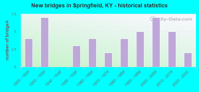
- New bridges - historical statistics
- 41920-1929
- 71930-1939
- 31950-1959
- 41960-1969
- 21970-1979
- 41980-1989
- 51990-1999
- 72000-2009
- 52010-2019
- 22020-2022

- Reconstructed bridges - Historical Statistics
- 12010-2019
- 12020-2022


- Bridge Condition - Deck
- 3.1%Excellent
- 21.9%Very good
- 43.8%Good
- 15.6%Satisfactory
- 15.6%Fair

- Bridge Condition - Superstructure
- 3.1%Excellent
- 40.6%Very good
- 25.0%Good
- 12.5%Satisfactory
- 6.3%Fair
- 12.5%Poor

- Bridge Condition - Substructure
- 3.1%Excellent
- 18.8%Very good
- 50.0%Good
- 15.6%Satisfactory
- 9.4%Fair
- 3.1%Poor

- Bridge Condition - Channel
- 4.8%Very good
- 73.8%Good
- 19.0%Satisfactory
- 2.4%Fair

- Bridge Condition - Culverts
- 9.1%Very good
- 36.4%Good
- 27.3%Satisfactory
- 9.1%Fair
- 18.2%Poor
Find on map >> Show street view
Structure Number: 115B00003N, Location: 1.5 MI SW OF JCT KY 1586 (Lat: 37.832500, Lng: -85.089167), Route carried "on" structure: State highway 53, Year Built: 1935, Status: Open, Structure Length: 3.23m (10.60ft), Average Daily Traffic: 385 (year 2018), Truck Traffic: 10%, Average Future Daily Traffic: 338 (year 2038), Design Load: H 15, Features Intersected: GLENNS CREEK
Minimum Vertical Clearance: 30+ m (98+ ft), Kilometerpoint: 9.135, Lanes on structure: 2, Owner: State Highway Agency, Approaching Roadway Width: 6.1m (20.0ft), Material/Design: Concrete, Design/Construction: Tee Beam, Number Of Spans In Main Unit: 2, Length of Maximum Span: 15.2m (49.9ft), Curb or Sidewalk Widths: Left: 0.2m (0.7ft), Right: 0.2m (0.7ft), Curb-To-Curb Width: 6.1m (20.0ft), Out-to-Out Width: 6.4m (21.0ft)
Condition: Deck: Satisfactory, Superstructure: Satisfactory, Substructure: Satisfactory, Channel: Satisfactory, Operating Rating: 54.7 metric tons, Method Used To Determine Operating Rating: Load Factor (LF), Inventory Rating: 32.8 metric tons, Method Used To Determine Inventory Rating: Load Factor (LF), Structural Evaluation: Equal to present minimum criteria, Deck Geometry: Meets minimum limits, Waterway Adequacy: Equal to present minimum criteria, Approach Roadway Alignment: Equal to present minimum criteria, Designated Inspection Frequency: Every 24 months, Inspection Date: March 2021, Deck Structure Type: Concrete Cast-file-Place, Wearing Surface/Protective System: Wearing Surface: Bituminous
Find on map >> Show street view
Structure Number: 115B00016N, Location: .02 MI SW OF JCT KY 55 (Lat: 37.664722, Lng: -85.234722), Route carried "on" structure: State highway 3164, Year Built: 1927, Status: Posted for load, Structure Length: 0.70m (2.30ft), Average Daily Traffic: 53 (year 2019), Average Future Daily Traffic: 46 (year 2039), Features Intersected: BOOKER BRANCH
Minimum Vertical Clearance: 30+ m (98+ ft), Kilometerpoint: 0.903, Lanes on structure: 2, Owner: State Highway Agency, Approaching Roadway Width: 5.5m (18.0ft), Material/Design: Concrete, Design/Construction: Culvert, Number Of Spans In Main Unit: 2, Length of Maximum Span: 3.0m (9.8ft)
Condition: Channel: Good, Culverts: Poor, Operating Rating: 14.5 metric tons, Method Used To Determine Operating Rating: Field evaluation and documented engineering judgment, Inventory Rating: 14.5 metric tons, Method Used To Determine Inventory Rating: Field evaluation and documented engineering judgment, Structural Evaluation: Meets minimum limits, Waterway Adequacy: Equal to present minimum criteria, Approach Roadway Alignment: Equal to present minimum criteria, Bridge Posting: Required (Relationship of Operating Rating to Maximum Legal Load: > 39.9% below), Designated Inspection Frequency: Every 12 months, Inspection Date: March 2021
Find on map >> Show street view
Structure Number: 115B00017N, Location: .2 MI SW OF JCT KY 55 (Lat: 37.649722, Lng: -85.242778), Route carried "on" structure: State highway 3165, Year Built: 1927, Status: Posted for load, Structure Length: 1.01m (3.31ft), Average Daily Traffic: 44 (year 2019), Average Future Daily Traffic: 38 (year 2039), Design Load: H 15, Features Intersected: SERVANTS RUN
Minimum Vertical Clearance: 30+ m (98+ ft), Kilometerpoint: 1.426, Lanes on structure: 2, Owner: State Highway Agency, Approaching Roadway Width: 6.1m (20.0ft), Material/Design: Concrete, Design/Construction: Tee Beam, Number Of Spans In Main Unit: 1, Length of Maximum Span: 9.1m (29.9ft), Curb or Sidewalk Widths: Left: 0.5m (1.6ft), Right: 0.5m (1.6ft), Curb-To-Curb Width: 5.8m (19.0ft), Out-to-Out Width: 6.0m (19.7ft)
Condition: Deck: Fair, Superstructure: Poor, Substructure: Satisfactory, Channel: Good, Operating Rating: 39.3 metric tons, Method Used To Determine Operating Rating: Load Factor (LF), Inventory Rating: 23.6 metric tons, Method Used To Determine Inventory Rating: Load Factor (LF), Structural Evaluation: Meets minimum limits, Deck Geometry: Meets minimum limits, Waterway Adequacy: Equal to present minimum criteria, Approach Roadway Alignment: Better than present minimum criteria, Bridge Posting: Required (Relationship of Operating Rating to Maximum Legal Load: 30.0 - 39.9% below), Length Of Structure Improvement: 0.10m (0.33ft), Designated Inspection Frequency: Every 24 months, Inspection Date: March 2021, Bridge Improvement Cost: $97,000, Total Project Cost: $97,000, Deck Structure Type: Concrete Cast-file-Place, Wearing Surface/Protective System: Wearing Surface: Bituminous
Find on map >> Show street view
Structure Number: 115B00018N, Location: 2.4 MI SOU. OF JCT KY 152 (Lat: 37.662778, Lng: -85.284722), Route carried "on" structure: State highway 429, Year Built: 1965, Status: Posted for load, Structure Length: 1.31m (4.30ft), Average Daily Traffic: 551 (year 2018), Average Future Daily Traffic: 484 (year 2038), Design Load: H 20, Features Intersected: SHEPHERDS RUN CREEK
Minimum Vertical Clearance: 30+ m (98+ ft), Kilometerpoint: 2.245, Lanes on structure: 2, Owner: State Highway Agency, Approaching Roadway Width: 11.6m (38.1ft), Skew: 4 degrees, Material/Design: Concrete, Design/Construction: Culvert, Number Of Spans In Main Unit: 2, Length of Maximum Span: 5.8m (19.0ft)
Condition: Channel: Good, Culverts: Satisfactory, Operating Rating: 20.0 metric tons, Method Used To Determine Operating Rating: Field evaluation and documented engineering judgment, Inventory Rating: 20.0 metric tons, Method Used To Determine Inventory Rating: Field evaluation and documented engineering judgment, Structural Evaluation: Somewhat better than minimum adequacy, Waterway Adequacy: Equal to present minimum criteria, Approach Roadway Alignment: Better than present minimum criteria, Bridge Posting: Required (Relationship of Operating Rating to Maximum Legal Load: > 39.9% below), Designated Inspection Frequency: Every 24 months, Inspection Date: March 2020
Find on map >> Show street view
Structure Number: 115B00019N, Location: .65 MI SW OF W-JCT US 150 (Lat: 37.693611, Lng: -85.256944), Route carried "on" structure: State highway 152, Year Built: 1934, Status: Posted for load, Structure Length: 5.24m (17.19ft), Average Daily Traffic: 2,128 (year 2020), Truck Traffic: 17%, Average Future Daily Traffic: 1,872 (year 2040), Design Load: H 15, Features Intersected: CARTWRIGHT CREEK
Minimum Vertical Clearance: 30+ m (98+ ft), Kilometerpoint: 11.859, Lanes on structure: 2, Owner: State Highway Agency, Approaching Roadway Width: 6.1m (20.0ft), Material/Design: Concrete, Design/Construction: Tee Beam, Number Of Spans In Main Unit: 4, Length of Maximum Span: 12.2m (40.0ft), Curb or Sidewalk Widths: Left: 0.3m (1.0ft), Right: 0.3m (1.0ft), Curb-To-Curb Width: 5.7m (18.7ft), Out-to-Out Width: 6.6m (21.7ft)
Condition: Deck: Satisfactory, Superstructure: Fair, Substructure: Satisfactory, Channel: Good, Operating Rating: 52.1 metric tons, Method Used To Determine Operating Rating: Load Factor (LF), Inventory Rating: 31.2 metric tons, Method Used To Determine Inventory Rating: Load Factor (LF), Structural Evaluation: Somewhat better than minimum adequacy, Deck Geometry: High priority of replacement, Waterway Adequacy: Better than present minimum criteria, Approach Roadway Alignment: Equal to present minimum criteria, Bridge Posting: Required (Relationship of Operating Rating to Maximum Legal Load: 10.0 - 19.9% below), Length Of Structure Improvement: 0.52m (1.71ft), Designated Inspection Frequency: Every 24 months, Inspection Date: March 2021, Bridge Improvement Cost: $462,000, Total Project Cost: $462,000, Deck Structure Type: Concrete Cast-file-Place, Wearing Surface/Protective System: Wearing Surface: Bituminous
Find on map >> Show street view
Structure Number: 115B00023N, Location: .02 MI SE OF JCT KY 1030 (Lat: 37.731389, Lng: -85.287222), Route carried "on" structure: US 150, Year Built: 1963, Status: Open, Structure Length: 5.85m (19.19ft), Average Daily Traffic: 7,811 (year 2020), Truck Traffic: 17%, Average Future Daily Traffic: 6,483 (year 2040), Design Load: HS 20, Features Intersected: CARTWRIGHT CREEK
Minimum Vertical Clearance: 30+ m (98+ ft), Kilometerpoint: 6.745, Lanes on structure: 2, Base Highway Network: Yes, Owner: State Highway Agency, Approaching Roadway Width: 7.3m (24.0ft), Skew: 4 degrees, Material/Design: Concrete, Design/Construction: Tee Beam, Number Of Spans In Main Unit: 4, Length of Maximum Span: 13.7m (44.9ft), Curb or Sidewalk Widths: Left: 0.3m (1.0ft), Right: 0.3m (1.0ft), Curb-To-Curb Width: 9.8m (32.2ft), Out-to-Out Width: 10.2m (33.5ft)
Condition: Deck: Fair, Superstructure: Fair, Substructure: Fair, Channel: Good, Operating Rating: 66.2 metric tons, Method Used To Determine Operating Rating: Load Factor (LF), Inventory Rating: 39.7 metric tons, Method Used To Determine Inventory Rating: Load Factor (LF), Structural Evaluation: Somewhat better than minimum adequacy, Deck Geometry: Meets minimum limits, Waterway Adequacy: Better than present minimum criteria, Approach Roadway Alignment: Equal to present minimum criteria, Designated Inspection Frequency: Every 24 months, Inspection Date: March 2021, Deck Structure Type: Concrete Cast-file-Place, Wearing Surface/Protective System: Wearing Surface: Latex Concrete
Find on map >> Show street view
Structure Number: 115B00024N, Location: .15 MI NOR. OF JCT US 150 (Lat: 37.693889, Lng: -85.234444), Route carried "on" structure: State highway 55, Year Built: 1933, Status: Posted for load, Structure Length: 1.46m (4.79ft), Average Daily Traffic: 2,464 (year 2018), Truck Traffic: 16%, Average Future Daily Traffic: 2,168 (year 2038), Design Load: H 15, Features Intersected: ROAD RUN CREEK
Minimum Vertical Clearance: 30+ m (98+ ft), Kilometerpoint: 7.612, Lanes on structure: 2, Owner: State Highway Agency, Approaching Roadway Width: 5.5m (18.0ft), Skew: 4 degrees, Material/Design: Concrete, Design/Construction: Tee Beam, Number Of Spans In Main Unit: 1, Length of Maximum Span: 13.7m (44.9ft), Curb-To-Curb Width: 5.8m (19.0ft), Out-to-Out Width: 6.1m (20.0ft)
Condition: Deck: Satisfactory, Superstructure: Poor, Substructure: Good, Channel: Good, Operating Rating: 38.5 metric tons, Method Used To Determine Operating Rating: Load Factor (LF), Inventory Rating: 23.0 metric tons, Method Used To Determine Inventory Rating: Load Factor (LF), Structural Evaluation: Meets minimum limits, Deck Geometry: High priority of replacement, Waterway Adequacy: Better than present minimum criteria, Approach Roadway Alignment: Better than present minimum criteria, Bridge Posting: Required (Relationship of Operating Rating to Maximum Legal Load: > 39.9% below), Length Of Structure Improvement: 0.15m (0.49ft), Designated Inspection Frequency: Every 24 months, Inspection Date: March 2020, Bridge Improvement Cost: $120,000, Total Project Cost: $120,000, Deck Structure Type: Concrete Cast-file-Place, Wearing Surface/Protective System: Wearing Surface: Bituminous
Find on map >> Show street view
Structure Number: 115B00026N, Location: 1.1 MI SOU. OF JCT KY 438 (Lat: 37.745000, Lng: -85.262778), Route carried "on" structure: State highway 55, Year Built: 1933, Year Reconstructed: 2019, Status: Open, Structure Length: 1.46m (4.79ft), Average Daily Traffic: 1,343 (year 2019), Truck Traffic: 16%, Average Future Daily Traffic: 1,181 (year 2039), Design Load: Greater than HL93, Features Intersected: SEIBERT CREEK
Minimum Vertical Clearance: 30+ m (98+ ft), Kilometerpoint: 13.959, Lanes on structure: 2, Owner: State Highway Agency, Approaching Roadway Width: 6.1m (20.0ft), Material/Design: Prestressed concrete, Design/Construction: Box Beam or Girders - Single/Spread, Number Of Spans In Main Unit: 1, Length of Maximum Span: 13.7m (44.9ft), Curb-To-Curb Width: 7.5m (24.6ft), Out-to-Out Width: 7.9m (25.9ft)
Condition: Deck: Very good, Superstructure: Very good, Substructure: Good, Channel: Satisfactory, Operating Rating: 70.0 metric tons, Method Used To Determine Operating Rating: Load and Resistance Factor Rating (LRFR) rating reported by rating factor(RF) method using HL-93 loadings, Inventory Rating: 53.8 metric tons, Method Used To Determine Inventory Rating: Load and Resistance Factor Rating (LRFR) rating reported by rating factor(RF) method using HL-93 loadings, Structural Evaluation: Better than present minimum criteria, Deck Geometry: Meets minimum limits, Waterway Adequacy: Better than present minimum criteria, Approach Roadway Alignment: Equal to present minimum criteria, Length Of Structure Improvement: 0.15m (0.49ft), Designated Inspection Frequency: Every 24 months, Inspection Date: March 2020, Bridge Improvement Cost: $146,000, Total Project Cost: $145,000, Deck Structure Type: Concrete Cast-file-Place, Wearing Surface/Protective System: Wearing Surface: Monolithic Concrete, Deck Protection: Epoxy Coated Reinforcing
Find on map >> Show street view
Structure Number: 115B00027N, Location: .10 MI SOU. OF JCT KY 438 (Lat: 37.756111, Lng: -85.251389), Route carried "on" structure: State highway 55, Year Built: 1927, Status: Posted for load, Structure Length: 0.98m (3.22ft), Average Daily Traffic: 1,343 (year 2019), Truck Traffic: 16%, Average Future Daily Traffic: 1,181 (year 2039), Features Intersected: LINCOLN BRANCH
Minimum Vertical Clearance: 30+ m (98+ ft), Kilometerpoint: 15.775, Lanes on structure: 2, Owner: State Highway Agency, Approaching Roadway Width: 6.1m (20.0ft), Skew: 4 degrees, Material/Design: Concrete, Design/Construction: Culvert, Number Of Spans In Main Unit: 2, Length of Maximum Span: 4.3m (14.1ft), Curb-To-Curb Width: 5.5m (18.0ft), Out-to-Out Width: 11.6m (38.1ft)
Condition: Channel: Satisfactory, Culverts: Poor, Operating Rating: 28.1 metric tons, Method Used To Determine Operating Rating: Field evaluation and documented engineering judgment, Inventory Rating: 18.1 metric tons, Method Used To Determine Inventory Rating: Field evaluation and documented engineering judgment, Structural Evaluation: Meets minimum limits, Deck Geometry: High priority of replacement, Waterway Adequacy: Equal to present minimum criteria, Approach Roadway Alignment: Equal to present minimum criteria, Bridge Posting: Required (Relationship of Operating Rating to Maximum Legal Load: > 39.9% below), Designated Inspection Frequency: Every 24 months, Inspection Date: March 2021
Find on map >> Show street view
Structure Number: 115B00036N, Location: 1.0 MI SOU. OF JCT US 150 (Lat: 37.721111, Lng: -85.301389), Route carried "on" structure: State highway 1030, Year Built: 1955, Status: Open, Structure Length: 0.82m (2.69ft), Average Daily Traffic: 240 (year 2020), Average Future Daily Traffic: 208 (year 2040), Design Load: H 15, Features Intersected: PARKERS RUN
Minimum Vertical Clearance: 30+ m (98+ ft), Kilometerpoint: 2.531, Lanes on structure: 2, Owner: State Highway Agency, Approaching Roadway Width: 7.9m (25.9ft), Skew: 3 degrees, Material/Design: Concrete, Design/Construction: Culvert, Number Of Spans In Main Unit: 2, Length of Maximum Span: 3.7m (12.1ft)
Condition: Channel: Satisfactory, Culverts: Good, Operating Rating: 54.4 metric tons, Method Used To Determine Operating Rating: Field evaluation and documented engineering judgment, Inventory Rating: 39.9 metric tons, Method Used To Determine Inventory Rating: Field evaluation and documented engineering judgment, Structural Evaluation: Better than present minimum criteria, Waterway Adequacy: Equal to present minimum criteria, Approach Roadway Alignment: Equal to present minimum criteria, Designated Inspection Frequency: Every 24 months, Inspection Date: March 2020
Find on map >> Show street view
Structure Number: 115B00038N, Location: .40 MI WEST OF JCT US 150 (Lat: 37.719444, Lng: -85.283333), Route carried "on" structure: State highway 1724, Year Built: 1958, Status: Open, Structure Length: 4.85m (15.91ft), Average Daily Traffic: 163 (year 2018), Average Future Daily Traffic: 141 (year 2038), Design Load: H 15, Features Intersected: CARTWRIGHT CREEK
Minimum Vertical Clearance: 30+ m (98+ ft), Kilometerpoint: 2.493, Lanes on structure: 2, Owner: State Highway Agency, Approaching Roadway Width: 4.9m (16.1ft), Material/Design: Concrete, Design/Construction: Tee Beam, Number Of Spans In Main Unit: 3, Length of Maximum Span: 15.2m (49.9ft), Curb or Sidewalk Widths: Left: 0.3m (1.0ft), Right: 0.3m (1.0ft), Curb-To-Curb Width: 6.7m (22.0ft), Out-to-Out Width: 7.3m (24.0ft)
Condition: Deck: Good, Superstructure: Good, Substructure: Satisfactory, Channel: Fair, Operating Rating: 60.7 metric tons, Method Used To Determine Operating Rating: Load Factor (LF), Inventory Rating: 36.5 metric tons, Method Used To Determine Inventory Rating: Load Factor (LF), Structural Evaluation: Equal to present minimum criteria, Deck Geometry: Meets minimum limits, Waterway Adequacy: Equal to present minimum criteria, Approach Roadway Alignment: Somewhat better than minimum adequacy, Designated Inspection Frequency: Every 24 months, Inspection Date: March 2020, Deck Structure Type: Concrete Cast-file-Place, Wearing Surface/Protective System: Wearing Surface: Latex Concrete
Find on map >> Show street view
Structure Number: 115B00044N, Location: .10 MI EAST OF JCT KY 555 (Lat: 37.688889, Lng: -85.229444), Route carried "on" structure: Business US 150, Year Built: 1961, Status: Open, Structure Length: 1.01m (3.31ft), Average Daily Traffic: 5,852 (year 2020), Truck Traffic: 8%, Average Future Daily Traffic: 4,857 (year 2040), Design Load: H 20, Features Intersected: ROAD RUN CREEK
Minimum Vertical Clearance: 30+ m (98+ ft), Kilometerpoint: 3.769, Lanes on structure: 2, Base Highway Network: Yes, Owner: State Highway Agency, Approaching Roadway Width: 19.8m (65.0ft), Skew: 4 degrees, Material/Design: Concrete, Design/Construction: Culvert, Number Of Spans In Main Unit: 1, Length of Maximum Span: 8.5m (27.9ft)
Condition: Channel: Good, Culverts: Good, Operating Rating: 47.0 metric tons, Method Used To Determine Operating Rating: Load and Resistance Factor Rating (LRFR) rating reported by rating factor(RF) method using HL-93 loadings, Inventory Rating: 36.3 metric tons, Method Used To Determine Inventory Rating: Load and Resistance Factor Rating (LRFR) rating reported by rating factor(RF) method using HL-93 loadings, Structural Evaluation: Better than present minimum criteria, Waterway Adequacy: Better than present minimum criteria, Approach Roadway Alignment: Equal to present desirable criteria, Designated Inspection Frequency: Every 24 months, Inspection Date: March 2020
Find on map >> Show street view
Structure Number: 115B00046N, Location: 2 MI N of JCT 555 & 150 (Lat: 37.725833, Lng: -85.191667), Route carried "on" structure: State highway 555, Year Built: 1975, Status: Open, Structure Length: 8.53m (27.99ft), Average Daily Traffic: 5,108 (year 2020), Truck Traffic: 17%, Average Future Daily Traffic: 4,801 (year 2040), Design Load: HS 20, Features Intersected: BEECH FORK RIVER
Minimum Vertical Clearance: 30+ m (98+ ft), Kilometerpoint: 5.601, Lanes on structure: 2, Base Highway Network: Yes, Owner: State Highway Agency, Approaching Roadway Width: 13.4m (44.0ft), Material/Design: Prestressed concrete continuous, Design/Construction: Stringer/Multi-beam, Number Of Spans In Main Unit: 3, Length of Maximum Span: 28.6m (93.8ft), Curb-To-Curb Width: 13.4m (44.0ft), Out-to-Out Width: 14.3m (46.9ft)
Condition: Deck: Good, Superstructure: Good, Substructure: Good, Channel: Satisfactory, Operating Rating: 99.8 metric tons, Method Used To Determine Operating Rating: Load Factor (LF), Inventory Rating: 71.8 metric tons, Method Used To Determine Inventory Rating: Load Factor (LF), Structural Evaluation: Better than present minimum criteria, Deck Geometry: Equal to present minimum criteria, Waterway Adequacy: Better than present minimum criteria, Approach Roadway Alignment: Equal to present minimum criteria, Designated Inspection Frequency: Every 24 months, Inspection Date: March 2020, Deck Structure Type: Concrete Cast-file-Place, Wearing Surface/Protective System: Wearing Surface: Latex Concrete
Find on map >> Show street view
Structure Number: 115B00047N, Location: 0.02 Mi N of US 150X (Lat: 37.702778, Lng: -85.211389), Route carried "on" structure: State highway 555, Year Built: 1976, Status: Open, Structure Length: 0.85m (2.79ft), Average Daily Traffic: 7,217 (year 2020), Truck Traffic: 19%, Average Future Daily Traffic: 6,783 (year 2040), Design Load: HS 20+Mod, Features Intersected: HAYDON BRANCH
Minimum Vertical Clearance: 30+ m (98+ ft), Kilometerpoint: 0.047, Lanes on structure: 2, Base Highway Network: Yes, Owner: State Highway Agency, Approaching Roadway Width: 31.7m (104.0ft), Skew: 1 degrees, Material/Design: Concrete, Design/Construction: Culvert, Number Of Spans In Main Unit: 2, Length of Maximum Span: 3.7m (12.1ft)
Condition: Channel: Good, Culverts: Satisfactory, Operating Rating: 54.4 metric tons, Method Used To Determine Operating Rating: Field evaluation and documented engineering judgment, Inventory Rating: 40.8 metric tons, Method Used To Determine Inventory Rating: Field evaluation and documented engineering judgment, Structural Evaluation: Equal to present minimum criteria, Waterway Adequacy: Better than present minimum criteria, Approach Roadway Alignment: Better than present minimum criteria, Designated Inspection Frequency: Every 24 months, Inspection Date: March 2021
Find on map >> Show street view
Structure Number: 115B00048N, Location: 1.55 MI NOR. OF MARION CL (Lat: 37.649167, Lng: -85.242222), Route carried "on" structure: State highway 55, Year Built: 1980, Status: Open, Structure Length: 0.79m (2.59ft), Average Daily Traffic: 9,698 (year 2019), Truck Traffic: 15%, Average Future Daily Traffic: 9,116 (year 2039), Features Intersected: SERVANT RUN
Minimum Vertical Clearance: 30+ m (98+ ft), Kilometerpoint: 2.536, Lanes on structure: 2, Base Highway Network: Yes, Owner: State Highway Agency, Approaching Roadway Width: 6.7m (22.0ft), Skew: 2 degrees, Material/Design: Concrete, Design/Construction: Culvert, Number Of Spans In Main Unit: 2, Length of Maximum Span: 3.0m (9.8ft)
Condition: Channel: Good, Culverts: Good, Operating Rating: 54.4 metric tons, Method Used To Determine Operating Rating: Field evaluation and documented engineering judgment, Inventory Rating: 39.9 metric tons, Method Used To Determine Inventory Rating: Field evaluation and documented engineering judgment, Structural Evaluation: Better than present minimum criteria, Waterway Adequacy: Equal to present desirable criteria, Approach Roadway Alignment: Better than present minimum criteria, Designated Inspection Frequency: Every 24 months, Inspection Date: March 2020
Find on map >> Show street view
Structure Number: 115B00049N, Location: 4.5 MI NE OF JCT US 150 (Lat: 37.704722, Lng: -85.146667), Route carried "on" structure: State highway 152, Year Built: 1986, Status: Open, Structure Length: 6.49m (21.29ft), Average Daily Traffic: 634 (year 2018), Average Future Daily Traffic: 557 (year 2038), Design Load: HS 20, Features Intersected: BEECH FORK RIVER
Minimum Vertical Clearance: 30+ m (98+ ft), Kilometerpoint: 19.578, Lanes on structure: 2, Owner: State Highway Agency, Approaching Roadway Width: 10.4m (34.1ft), Material/Design: Prestressed concrete continuous, Design/Construction: Stringer/Multi-beam, Number Of Spans In Main Unit: 3, Length of Maximum Span: 24.4m (80.1ft), Curb-To-Curb Width: 8.5m (27.9ft), Out-to-Out Width: 9.5m (31.2ft)
Condition: Deck: Good, Superstructure: Good, Substructure: Good, Channel: Good, Operating Rating: 72.3 metric tons, Method Used To Determine Operating Rating: Load Factor (LF), Inventory Rating: 43.4 metric tons, Method Used To Determine Inventory Rating: Load Factor (LF), Structural Evaluation: Better than present minimum criteria, Deck Geometry: Somewhat better than minimum adequacy, Waterway Adequacy: Equal to present desirable criteria, Approach Roadway Alignment: Better than present minimum criteria, Designated Inspection Frequency: Every 24 months, Inspection Date: March 2021, Deck Structure Type: Concrete Cast-file-Place, Wearing Surface/Protective System: Wearing Surface: Monolithic Concrete
Find on map >> Show street view
Structure Number: 115B00055N, Location: .1 MI. SW JCT KY 528 (Lat: 37.760000, Lng: -85.216111), Route carried "on" structure: State highway 438, Year Built: 1995, Status: Posted for load, Structure Length: 0.79m (2.59ft), Average Daily Traffic: 357 (year 2019), Average Future Daily Traffic: 314 (year 2039), Design Load: HS 25 or greater, Features Intersected: LINCOLN RUN
Minimum Vertical Clearance: 30+ m (98+ ft), Kilometerpoint: 3.446, Lanes on structure: 2, Owner: State Highway Agency, Approaching Roadway Width: 6.4m (21.0ft), Skew: 2 degrees, Material/Design: Prestressed concrete, Design/Construction: Box Beam or Girders - Multiple, Number Of Spans In Main Unit: 1, Length of Maximum Span: 7.0m (23.0ft), Curb-To-Curb Width: 6.9m (22.6ft), Out-to-Out Width: 7.5m (24.6ft)
Condition: Deck: Good, Superstructure: Very good, Substructure: Good, Channel: Very good, Operating Rating: 52.6 metric tons, Method Used To Determine Operating Rating: Load Factor (LF), Inventory Rating: 31.6 metric tons, Method Used To Determine Inventory Rating: Load Factor (LF), Structural Evaluation: Better than present minimum criteria, Deck Geometry: Meets minimum limits, Waterway Adequacy: Better than present minimum criteria, Approach Roadway Alignment: Equal to present minimum criteria, Bridge Posting: Required (Relationship of Operating Rating to Maximum Legal Load: 20.0 - 29.9% below), Designated Inspection Frequency: Every 24 months, Inspection Date: March 2021, Deck Structure Type: Concrete Precast Panels, Wearing Surface/Protective System: Wearing Surface: Epoxy Overlay, Membrane: Preformed Fabric, Deck Protection: Epoxy Coated Reinforcing
Find on map >> Show street view
Structure Number: 115B00056N, Location: 2.7 MI. SE SECL-SPNGFIELD (Lat: 37.661111, Lng: -85.172500), Route carried "on" structure: US 150, Year Built: 1996, Status: Open, Structure Length: 4.36m (14.30ft), Average Daily Traffic: 4,008 (year 2019), Truck Traffic: 17%, Average Future Daily Traffic: 3,326 (year 2039), Design Load: HS 25 or greater, Features Intersected: MILL CREEK
Minimum Vertical Clearance: 30+ m (98+ ft), Kilometerpoint: 20.891, Lanes on structure: 2, Base Highway Network: Yes, Owner: State Highway Agency, Approaching Roadway Width: 14.6m (47.9ft), Skew: 2 degrees, Material/Design: Prestressed concrete continuous, Design/Construction: Stringer/Multi-beam, Number Of Spans In Main Unit: 3, Length of Maximum Span: 17.7m (58.1ft), Curb-To-Curb Width: 14.9m (48.9ft), Out-to-Out Width: 15.8m (51.8ft)
Condition: Deck: Good, Superstructure: Very good, Substructure: Good, Channel: Good, Operating Rating: 73.3 metric tons, Method Used To Determine Operating Rating: Load Factor (LF), Inventory Rating: 44.0 metric tons, Method Used To Determine Inventory Rating: Load Factor (LF), Structural Evaluation: Better than present minimum criteria, Deck Geometry: Superior to present desirable criteria, Waterway Adequacy: Equal to present desirable criteria, Approach Roadway Alignment: Equal to present desirable criteria, Designated Inspection Frequency: Every 24 months, Inspection Date: March 2020, Deck Structure Type: Concrete Cast-file-Place, Wearing Surface/Protective System: Wearing Surface: Monolithic Concrete, Deck Protection: Epoxy Coated Reinforcing
Find on map >> Show street view
Structure Number: 115B00057N, Location: 3.5 MI.SE. SELL -SPRNGFLD (Lat: 37.660556, Lng: -85.155833), Route carried "on" structure: US 150, Year Built: 1996, Status: Open, Structure Length: 5.58m (18.31ft), Average Daily Traffic: 4,008 (year 2019), Truck Traffic: 17%, Average Future Daily Traffic: 3,326 (year 2039), Design Load: HS 25 or greater, Features Intersected: PLEASANT RUN
Minimum Vertical Clearance: 30+ m (98+ ft), Kilometerpoint: 22.380, Lanes on structure: 2, Base Highway Network: Yes, Owner: State Highway Agency, Approaching Roadway Width: 14.6m (47.9ft), Material/Design: Prestressed concrete continuous, Design/Construction: Stringer/Multi-beam, Number Of Spans In Main Unit: 3, Length of Maximum Span: 18.3m (60.0ft), Curb-To-Curb Width: 13.3m (43.6ft), Out-to-Out Width: 15.8m (51.8ft)
Condition: Deck: Satisfactory, Superstructure: Very good, Substructure: Good, Channel: Very good, Operating Rating: 62.0 metric tons, Method Used To Determine Operating Rating: Load Factor (LF), Inventory Rating: 37.2 metric tons, Method Used To Determine Inventory Rating: Load Factor (LF), Structural Evaluation: Better than present minimum criteria, Deck Geometry: Equal to present minimum criteria, Waterway Adequacy: Equal to present desirable criteria, Approach Roadway Alignment: Equal to present desirable criteria, Designated Inspection Frequency: Every 24 months, Inspection Date: March 2021, Deck Structure Type: Concrete Cast-file-Place, Wearing Surface/Protective System: Wearing Surface: Monolithic Concrete, Deck Protection: Epoxy Coated Reinforcing
Find on map >> Show street view
Structure Number: 115B00062N, Location: 0.6 MI E. OF JCT US 150 (Lat: 37.694722, Lng: -85.215000), Route carried "on" structure: State highway 1584, Year Built: 2003, Status: Open, Structure Length: 0.85m (2.79ft), Average Daily Traffic: 590 (year 2020), Average Future Daily Traffic: 513 (year 2040), Design Load: HS 25 or greater, Features Intersected: POORHOUSE BRANCH
Minimum Vertical Clearance: 30+ m (98+ ft), Kilometerpoint: 1.291, Lanes on structure: 2, Owner: State Highway Agency, Approaching Roadway Width: 7.0m (23.0ft), Skew: 1 degrees, Material/Design: Prestressed concrete, Design/Construction: Box Beam or Girders - Single/Spread, Number Of Spans In Main Unit: 1, Length of Maximum Span: 7.6m (24.9ft), Curb-To-Curb Width: 9.1m (29.9ft), Out-to-Out Width: 9.6m (31.5ft)
Condition: Deck: Very good, Superstructure: Very good, Substructure: Very good, Channel: Good, Operating Rating: 99.8 metric tons, Method Used To Determine Operating Rating: Load Factor (LF), Inventory Rating: 68.1 metric tons, Method Used To Determine Inventory Rating: Load Factor (LF), Structural Evaluation: Equal to present desirable criteria, Deck Geometry: Equal to present minimum criteria, Waterway Adequacy: Better than present minimum criteria, Approach Roadway Alignment: Equal to present minimum criteria, Designated Inspection Frequency: Every 24 months, Inspection Date: March 2020, Deck Structure Type: Concrete Cast-file-Place, Wearing Surface/Protective System: Wearing Surface: Monolithic Concrete, Deck Protection: Epoxy Coated Reinforcing
Find on map >> Show street view
Structure Number: 115B00066N, Location: 0.1 Mi N of Bypass (Lat: 37.707500, Lng: -85.234722), Route carried "on" structure: State highway 55, Year Built: 2009, Status: Open, Structure Length: 1.62m (5.31ft), Average Daily Traffic: 1,343 (year 2019), Truck Traffic: 16%, Average Future Daily Traffic: 1,181 (year 2039), Design Load: Greater than HL93, Features Intersected: Shay Branch
Minimum Vertical Clearance: 30+ m (98+ ft), Kilometerpoint: 9.061, Lanes on structure: 2, Owner: State Highway Agency, Approaching Roadway Width: 16.5m (54.1ft), Skew: 3 degrees, Material/Design: Prestressed concrete, Design/Construction: Box Beam or Girders - Single/Spread, Number Of Spans In Main Unit: 1, Length of Maximum Span: 15.2m (49.9ft), Curb-To-Curb Width: 16.5m (54.1ft), Out-to-Out Width: 17.2m (56.4ft)
Condition: Deck: Very good, Superstructure: Very good, Substructure: Good, Channel: Good, Operating Rating: 87.8 metric tons, Method Used To Determine Operating Rating: Load and Resistance Factor Rating (LRFR) rating reported by rating factor(RF) method using HL-93 loadings, Inventory Rating: 67.7 metric tons, Method Used To Determine Inventory Rating: Load and Resistance Factor Rating (LRFR) rating reported by rating factor(RF) method using HL-93 loadings, Structural Evaluation: Better than present minimum criteria, Deck Geometry: Superior to present desirable criteria, Waterway Adequacy: Equal to present desirable criteria, Approach Roadway Alignment: Equal to present desirable criteria, Designated Inspection Frequency: Every 24 months, Inspection Date: March 2020, Deck Structure Type: Concrete Cast-file-Place, Wearing Surface/Protective System: Wearing Surface: Monolithic Concrete, Deck Protection: Epoxy Coated Reinforcing
Find on map >> Show street view
Structure Number: 115B00067N, Location: 200' W of Jct. KY 55 (Lat: 37.706667, Lng: -85.235278), Route carried "on" structure: US 150, Year Built: 2009, Status: Open, Structure Length: 1.92m (6.30ft), Average Daily Traffic: 4,394 (year 2019), Truck Traffic: 19%, Average Future Daily Traffic: 3,647 (year 2039), Design Load: HS 25 or greater, Features Intersected: Road Run Creek
Minimum Vertical Clearance: 30.18m (99.02ft), Kilometerpoint: 12.516, Lanes on structure: 2, Base Highway Network: Yes, Owner: State Highway Agency, Approaching Roadway Width: 18.3m (60.0ft), Skew: 3 degrees, Material/Design: Prestressed concrete, Design/Construction: Stringer/Multi-beam, Number Of Spans In Main Unit: 1, Length of Maximum Span: 18.3m (60.0ft), Curb-To-Curb Width: 18.3m (60.0ft), Out-to-Out Width: 19.2m (63.0ft)
Condition: Deck: Very good, Superstructure: Very good, Substructure: Good, Channel: Good, Operating Rating: 77.3 metric tons, Method Used To Determine Operating Rating: Load Factor (LF), Inventory Rating: 46.4 metric tons, Method Used To Determine Inventory Rating: Load Factor (LF), Structural Evaluation: Better than present minimum criteria, Deck Geometry: Superior to present desirable criteria, Waterway Adequacy: Better than present minimum criteria, Approach Roadway Alignment: Equal to present desirable criteria, Designated Inspection Frequency: Every 24 months, Inspection Date: March 2021, Deck Structure Type: Concrete Cast-file-Place, Wearing Surface/Protective System: Wearing Surface: Monolithic Concrete, Deck Protection: Epoxy Coated Reinforcing
Find on map >> Show street view
Structure Number: 115B00068N, Location: Int US 150 & KY 528 (Lat: 37.706667, Lng: -85.225833), Route carried "on" structure: US 150, Year Built: 2009, Status: Open, Structure Length: 1.37m (4.49ft), Average Daily Traffic: 5,158 (year 2020), Truck Traffic: 19%, Average Future Daily Traffic: 4,281 (year 2040), Design Load: HS 25 or greater, Features Intersected: Shay Branch
Minimum Vertical Clearance: 30+ m (98+ ft), Kilometerpoint: 13.378, Lanes on structure: 2, Base Highway Network: Yes, Owner: State Highway Agency, Approaching Roadway Width: 18.3m (60.0ft), Skew: 5 degrees, Material/Design: Concrete, Design/Construction: Culvert, Number Of Spans In Main Unit: 2, Length of Maximum Span: 4.3m (14.1ft)
Condition: Channel: Good, Culverts: Good, Operating Rating: 54.4 metric tons, Method Used To Determine Operating Rating: Field evaluation and documented engineering judgment, Inventory Rating: 39.9 metric tons, Method Used To Determine Inventory Rating: Field evaluation and documented engineering judgment, Structural Evaluation: Better than present minimum criteria, Waterway Adequacy: Equal to present desirable criteria, Approach Roadway Alignment: Equal to present desirable criteria, Designated Inspection Frequency: Every 24 months, Inspection Date: March 2020
Find on map >> Show street view
Structure Number: 115B00069N, Location: Int of US 150 & KY 555 (Lat: 37.690833, Lng: -85.232500), Route carried "on" structure: US 150, Year Built: 2009, Status: Open, Structure Length: 0.64m (2.10ft), Average Daily Traffic: 3,698 (year 2019), Truck Traffic: 19%, Average Future Daily Traffic: 3,069 (year 2039), Design Load: HS 25 or greater, Features Intersected: Haydon Branch
Minimum Vertical Clearance: 30+ m (98+ ft), Kilometerpoint: 14.779, Lanes on structure: 2, Base Highway Network: Yes, Owner: State Highway Agency, Approaching Roadway Width: 21.9m (71.9ft), Skew: 5 degrees, Material/Design: Concrete, Design/Construction: Culvert, Number Of Spans In Main Unit: 1, Length of Maximum Span: 6.4m (21.0ft)
Condition: Channel: Good, Culverts: Satisfactory, Operating Rating: 89.8 metric tons, Method Used To Determine Operating Rating: Load Factor (LF), Inventory Rating: 89.8 metric tons, Method Used To Determine Inventory Rating: Load Factor (LF), Structural Evaluation: Equal to present minimum criteria, Waterway Adequacy: Superior to present desirable criteria, Approach Roadway Alignment: Equal to present desirable criteria, Designated Inspection Frequency: Every 24 months, Inspection Date: March 2021
Find on map >> Show street view
Structure Number: 115B00073N, Location: 0.1 Mi S of Jct US 150 (Lat: 37.684167, Lng: -85.222778), Route carried "on" structure: State highway 528, Year Built: 1923, Year Reconstructed: 2020, Status: Open, Structure Length: 1.13m (3.71ft), Average Daily Traffic: 2,631 (year 2017), Truck Traffic: 6%, Average Future Daily Traffic: 2,315 (year 2037), Design Load: Greater than HL93, Features Intersected: Road Run Branch
Minimum Vertical Clearance: 30+ m (98+ ft), Kilometerpoint: 2.313, Lanes on structure: 2, Owner: State Highway Agency, Approaching Roadway Width: 7.3m (24.0ft), Material/Design: Prestressed concrete, Design/Construction: Box Beam or Girders - Single/Spread, Number Of Spans In Main Unit: 1, Length of Maximum Span: 10.7m (35.1ft), Curb or Sidewalk Widths: Left: 1.9m (6.2ft), Right: 3.4m (11.2ft), Curb-To-Curb Width: 8.7m (28.5ft), Out-to-Out Width: 14.6m (47.9ft)
Condition: Deck: Very good, Superstructure: Good, Substructure: Good, Channel: Good, Operating Rating: 53.1 metric tons, Method Used To Determine Operating Rating: Load and Resistance Factor Rating (LRFR) rating reported by rating factor(RF) method using HL-93 loadings, Inventory Rating: 40.8 metric tons, Method Used To Determine Inventory Rating: Load and Resistance Factor Rating (LRFR) rating reported by rating factor(RF) method using HL-93 loadings, Structural Evaluation: Better than present minimum criteria, Deck Geometry: Meets minimum limits, Waterway Adequacy: Better than present minimum criteria, Approach Roadway Alignment: Equal to present desirable criteria, Designated Inspection Frequency: Every 24 months, Inspection Date: March 2021, Deck Structure Type: Concrete Cast-file-Place, Wearing Surface/Protective System: Wearing Surface: Monolithic Concrete, Deck Protection: Epoxy Coated Reinforcing
Find on map >> Show street view
Structure Number: 115C00001N, Location: 0.8 MI E OF JCT KY 1586 (Lat: 37.806111, Lng: -85.020000), Route carried "on" structure: County highway 1012, Year Built: 1935, Status: Posted for load, Structure Length: 1.19m (3.90ft), Average Daily Traffic: 22 (year 2010), Average Future Daily Traffic: 19 (year 2030), Features Intersected: THREE LICK CREEK, Facility Carried by Structure: THREE LICK LN
Minimum Vertical Clearance: 30+ m (98+ ft), Kilometerpoint: 1.213, Lanes on structure: 1, Owner: County Highway Agency, Approaching Roadway Width: 4.6m (15.1ft), Skew: 2 degrees, Material/Design: Steel, Design/Construction: Stringer/Multi-beam, Number Of Spans In Main Unit: 1, Length of Maximum Span: 11.6m (38.1ft), Curb or Sidewalk Widths: Left: 0.2m (0.7ft), Right: 0.2m (0.7ft), Curb-To-Curb Width: 4.7m (15.4ft), Out-to-Out Width: 4.9m (16.1ft)
Condition: Deck: Fair, Superstructure: Poor, Substructure: Fair, Channel: Satisfactory, Operating Rating: 13.0 metric tons, Method Used To Determine Operating Rating: Load Factor (LF), Inventory Rating: 7.8 metric tons, Method Used To Determine Inventory Rating: Load Factor (LF), Structural Evaluation: High priority of replacement, Deck Geometry: Better than present minimum criteria, Waterway Adequacy: Equal to present minimum criteria, Approach Roadway Alignment: Equal to present minimum criteria, Bridge Posting: Required (Relationship of Operating Rating to Maximum Legal Load: > 39.9% below), Length Of Structure Improvement: 0.12m (0.39ft), Designated Inspection Frequency: Every 12 months, Inspection Date: August 2021, Bridge Improvement Cost: $94,000, Total Project Cost: $93,000, Deck Structure Type: Concrete Cast-file-Place, Wearing Surface/Protective System: Wearing Surface: Monolithic Concrete
Find on map >> Show street view
Structure Number: 115C00036N, Location: 1.5 MI NW OF JCT KY 55 (Lat: 37.761111, Lng: -85.284444), Route carried "on" structure: County highway 1314, Year Built: 1935, Status: Posted for load, Structure Length: 1.07m (3.51ft), Average Daily Traffic: 242 (year 2010), Average Future Daily Traffic: 210 (year 2030), Features Intersected: BR OF CARTWRIGHT CREEK, Facility Carried by Structure: VALLEY HILL RD
Minimum Vertical Clearance: 30+ m (98+ ft), Kilometerpoint: 2.567, Lanes on structure: 1, Owner: County Highway Agency, Approaching Roadway Width: 3.7m (12.1ft), Skew: 1 degrees, Material/Design: Steel, Design/Construction: Stringer/Multi-beam, Number Of Spans In Main Unit: 2, Length of Maximum Span: 6.4m (21.0ft), Curb or Sidewalk Widths: Left: 0.2m (0.7ft), Right: 0.2m (0.7ft), Curb-To-Curb Width: 4.1m (13.5ft), Out-to-Out Width: 4.9m (16.1ft)
Condition: Deck: Good, Superstructure: Good, Substructure: Fair, Channel: Good, Operating Rating: 23.7 metric tons, Method Used To Determine Operating Rating: Load Factor (LF), Inventory Rating: 14.2 metric tons, Method Used To Determine Inventory Rating: Load Factor (LF), Structural Evaluation: Meets minimum limits, Deck Geometry: High priority of replacement, Waterway Adequacy: Better than present minimum criteria, Approach Roadway Alignment: Somewhat better than minimum adequacy, Bridge Posting: Required (Relationship of Operating Rating to Maximum Legal Load: > 39.9% below), Designated Inspection Frequency: Every 12 months, Inspection Date: August 2021, Deck Structure Type: Concrete Cast-file-Place, Wearing Surface/Protective System: Wearing Surface: Bituminous
Find on map >> Show street view
Structure Number: 115C00038N, Location: .1 MI. E. JCT KY 152 (Lat: 37.701667, Lng: -85.143056), Route carried "on" structure: County highway 1149, Year Built: 1982, Status: Open, Structure Length: 1.52m (4.99ft), Average Daily Traffic: 49 (year 2010), Average Future Daily Traffic: 42 (year 2030), Features Intersected: MILL RUN CREEK, Facility Carried by Structure: HAGAN LN
Minimum Vertical Clearance: 30+ m (98+ ft), Kilometerpoint: 0.119, Lanes on structure: 1, Owner: County Highway Agency, Approaching Roadway Width: 4.3m (14.1ft), Material/Design: Steel, Design/Construction: Stringer/Multi-beam, Number Of Spans In Main Unit: 1, Length of Maximum Span: 15.2m (49.9ft), Curb or Sidewalk Widths: Left: 0.2m (0.7ft), Right: 0.2m (0.7ft), Curb-To-Curb Width: 4.3m (14.1ft), Out-to-Out Width: 4.6m (15.1ft)
Condition: Deck: Good, Superstructure: Satisfactory, Substructure: Good, Channel: Good, Operating Rating: 53.5 metric tons, Method Used To Determine Operating Rating: Load Factor (LF), Inventory Rating: 32.1 metric tons, Method Used To Determine Inventory Rating: Load Factor (LF), Structural Evaluation: Equal to present minimum criteria, Deck Geometry: Equal to present minimum criteria, Waterway Adequacy: Better than present minimum criteria, Approach Roadway Alignment: Equal to present minimum criteria, Designated Inspection Frequency: Every 24 months, Inspection Date: August 2020, Deck Structure Type: Concrete Cast-file-Place, Wearing Surface/Protective System: Wearing Surface: Monolithic Concrete, Deck Protection: Epoxy Coated Reinforcing
Find on map >> Show street view
Structure Number: 115C00041N, Location: 0.8 MI. N. - JCT KY 429 (Lat: 37.659722, Lng: -85.273056), Route carried "on" structure: County highway 1214, Year Built: 1987, Status: Open, Structure Length: 3.14m (10.30ft), Average Daily Traffic: 534 (year 2010), Average Future Daily Traffic: 464 (year 2030), Design Load: HS 25 or greater, Features Intersected: CARTWRIGHT CREEK, Facility Carried by Structure: BOOKER RD
Minimum Vertical Clearance: 30+ m (98+ ft), Kilometerpoint: 4.291, Lanes on structure: 1, Owner: County Highway Agency, Approaching Roadway Width: 5.5m (18.0ft), Skew: 1 degrees, Material/Design: Prestressed concrete, Design/Construction: Box Beam or Girders - Multiple, Number Of Spans In Main Unit: 1, Length of Maximum Span: 30.5m (100.1ft), Curb or Sidewalk Widths: Left: 0.2m (0.7ft), Right: 0.2m (0.7ft), Curb-To-Curb Width: 4.3m (14.1ft), Out-to-Out Width: 4.7m (15.4ft)
Condition: Deck: Fair, Superstructure: Satisfactory, Substructure: Good, Channel: Good, Operating Rating: 69.0 metric tons, Method Used To Determine Operating Rating: Load Factor (LF), Inventory Rating: 41.5 metric tons, Method Used To Determine Inventory Rating: Load Factor (LF), Structural Evaluation: Equal to present minimum criteria, Deck Geometry: High priority of replacement, Waterway Adequacy: Equal to present minimum criteria, Approach Roadway Alignment: Somewhat better than minimum adequacy, Length Of Structure Improvement: 0.31m (1.02ft), Designated Inspection Frequency: Every 24 months, Inspection Date: August 2021, Bridge Improvement Cost: $200,000, Total Project Cost: $199,000, Deck Structure Type: Concrete Precast Panels, Wearing Surface/Protective System: Wearing Surface: Monolithic Concrete, Deck Protection: Epoxy Coated Reinforcing
Find on map >> Show street view
Structure Number: 115C00044N, Location: .1 MI W JCT KY 55 (Lat: 37.750278, Lng: -85.261944), Route carried "on" structure: County highway 1314, Year Built: 1991, Status: Open, Structure Length: 1.16m (3.81ft), Average Daily Traffic: 242 (year 2010), Average Future Daily Traffic: 210 (year 2030), Design Load: HS 25 or greater, Features Intersected: TRIB-CARTWRIGHT CREEK, Facility Carried by Structure: VALLEY HILL RD
Minimum Vertical Clearance: 30+ m (98+ ft), Kilometerpoint: 0.079, Lanes on structure: 1, Owner: County Highway Agency, Approaching Roadway Width: 4.0m (13.1ft), Skew: 1 degrees, Material/Design: Prestressed concrete, Design/Construction: Box Beam or Girders - Multiple, Number Of Spans In Main Unit: 1, Length of Maximum Span: 11.3m (37.1ft), Curb-To-Curb Width: 4.5m (14.8ft), Out-to-Out Width: 4.9m (16.1ft)
Condition: Deck: Good, Superstructure: Very good, Substructure: Good, Channel: Good, Operating Rating: 63.8 metric tons, Method Used To Determine Operating Rating: Load Factor (LF), Inventory Rating: 38.3 metric tons, Method Used To Determine Inventory Rating: Load Factor (LF), Structural Evaluation: Better than present minimum criteria, Deck Geometry: High priority of replacement, Waterway Adequacy: Equal to present minimum criteria, Approach Roadway Alignment: Better than present minimum criteria, Designated Inspection Frequency: Every 24 months, Inspection Date: August 2020, Deck Structure Type: Concrete Precast Panels, Wearing Surface/Protective System: Wearing Surface: Monolithic Concrete
Find on map >> Show street view
Structure Number: 115C00047N, Location: 2 MI SW JCT KY 55 (Lat: 37.661111, Lng: -85.255000), Route carried "on" structure: County highway 1214, Year Built: 1991, Status: Open, Structure Length: 1.55m (5.09ft), Average Daily Traffic: 534 (year 2010), Average Future Daily Traffic: 464 (year 2030), Design Load: HS 25 or greater, Features Intersected: SERVANT RUN CREEK, Facility Carried by Structure: BOOKER RD
Minimum Vertical Clearance: 30+ m (98+ ft), Kilometerpoint: 2.667, Lanes on structure: 1, Owner: County Highway Agency, Approaching Roadway Width: 5.5m (18.0ft), Skew: 1 degrees, Material/Design: Prestressed concrete, Design/Construction: Box Beam or Girders - Multiple, Number Of Spans In Main Unit: 1, Length of Maximum Span: 14.6m (47.9ft), Curb-To-Curb Width: 4.6m (15.1ft), Out-to-Out Width: 5.0m (16.4ft)
Condition: Deck: Satisfactory, Superstructure: Good, Substructure: Good, Channel: Good, Operating Rating: 68.2 metric tons, Method Used To Determine Operating Rating: Load Factor (LF), Inventory Rating: 40.9 metric tons, Method Used To Determine Inventory Rating: Load Factor (LF), Structural Evaluation: Better than present minimum criteria, Deck Geometry: High priority of replacement, Waterway Adequacy: Equal to present minimum criteria, Approach Roadway Alignment: Equal to present minimum criteria, Length Of Structure Improvement: 0.16m (0.52ft), Designated Inspection Frequency: Every 24 months, Inspection Date: August 2021, Bridge Improvement Cost: $105,000, Total Project Cost: $105,000, Deck Structure Type: Concrete Precast Panels, Wearing Surface/Protective System: Wearing Surface: Monolithic Concrete, Deck Protection: Epoxy Coated Reinforcing
Find on map >> Show street view
Structure Number: 115C00054N, Location: 1.1 MI W OF JCT KY 1195 (Lat: 37.664167, Lng: -85.159167), Route carried "on" structure: County highway 1145, Year Built: 1930, Status: Posted for load, Structure Length: 2.62m (8.60ft), Average Daily Traffic: 80 (year 2010), Average Future Daily Traffic: 69 (year 2030), Design Load: H 15, Features Intersected: PLEASANT RUN, Facility Carried by Structure: PERRYVILLE LOOP
Minimum Vertical Clearance: 30+ m (98+ ft), Kilometerpoint: 2.586, Lanes on structure: 2, Owner: County Highway Agency, Approaching Roadway Width: 6.1m (20.0ft), Skew: 3 degrees, Material/Design: Concrete, Design/Construction: Tee Beam, Number Of Spans In Main Unit: 2, Length of Maximum Span: 12.2m (40.0ft), Curb or Sidewalk Widths: Left: 0.1m (0.3ft), Right: 0.1m (0.3ft), Curb-To-Curb Width: 7.0m (23.0ft), Out-to-Out Width: 7.4m (24.3ft)
Condition: Deck: Good, Superstructure: Satisfactory, Substructure: Satisfactory, Channel: Good, Operating Rating: 45.2 metric tons, Method Used To Determine Operating Rating: Load Factor (LF), Inventory Rating: 27.1 metric tons, Method Used To Determine Inventory Rating: Load Factor (LF), Structural Evaluation: Equal to present minimum criteria, Deck Geometry: Somewhat better than minimum adequacy, Waterway Adequacy: Better than present minimum criteria, Approach Roadway Alignment: Equal to present minimum criteria, Bridge Posting: Required (Relationship of Operating Rating to Maximum Legal Load: 20.0 - 29.9% below), Length Of Structure Improvement: 0.26m (0.85ft), Designated Inspection Frequency: Every 24 months, Inspection Date: August 2020, Bridge Improvement Cost: $261,000, Total Project Cost: $261,000, Deck Structure Type: Concrete Cast-file-Place, Wearing Surface/Protective System: Wearing Surface: Bituminous
Find on map >> Show street view
Structure Number: 115C00061N, Location: 300' WEST OF JCT. KY 429 (Lat: 37.654167, Lng: -85.290556), Route carried "on" structure: County highway 1223, Year Built: 2001, Status: Posted for load, Structure Length: 1.49m (4.89ft), Average Daily Traffic: 211 (year 2010), Average Future Daily Traffic: 183 (year 2030), Features Intersected: CARTWRIGHT CREEK, Facility Carried by Structure: SMITH LN
Minimum Vertical Clearance: 30+ m (98+ ft), Kilometerpoint: 0.082, Lanes on structure: 2, Owner: County Highway Agency, Approaching Roadway Width: 7.0m (23.0ft), Skew: 1 degrees, Material/Design: Steel, Design/Construction: Stringer/Multi-beam, Number Of Spans In Main Unit: 1, Length of Maximum Span: 11.6m (38.1ft), Curb or Sidewalk Widths: Left: 0.2m (0.7ft), Right: 0.2m (0.7ft), Curb-To-Curb Width: 7.0m (23.0ft), Out-to-Out Width: 7.4m (24.3ft)
Condition: Deck: Good, Superstructure: Good, Substructure: Good, Channel: Satisfactory, Operating Rating: 41.5 metric tons, Method Used To Determine Operating Rating: Load Factor (LF), Inventory Rating: 24.9 metric tons, Method Used To Determine Inventory Rating: Load Factor (LF), Structural Evaluation: Equal to present minimum criteria, Deck Geometry: Meets minimum limits, Waterway Adequacy: Equal to present minimum criteria, Approach Roadway Alignment: Better than present minimum criteria, Bridge Posting: Required (Relationship of Operating Rating to Maximum Legal Load: 30.0 - 39.9% below), Designated Inspection Frequency: Every 24 months, Inspection Date: August 2021, Deck Structure Type: Concrete Cast-file-Place, Wearing Surface/Protective System: Wearing Surface: Monolithic Concrete
Find on map >> Show street view
Structure Number: 115C00064N, Location: _ (Lat: 37.683611, Lng: -85.221111), Route carried "on" structure: City street 1050, Year Built: 1960, Status: Posted for load, Structure Length: 0.82m (2.69ft), Average Daily Traffic: 608 (year 2010), Average Future Daily Traffic: 528 (year 2030), Features Intersected: Road Run Creek, Facility Carried by Structure: South Walnut St
Minimum Vertical Clearance: 30+ m (98+ ft), Kilometerpoint: 0.138, Lanes on structure: 2, Owner: City or Municipal Highway Agency, Approaching Roadway Width: 6.1m (20.0ft), Material/Design: Concrete, Design/Construction: Culvert, Number Of Spans In Main Unit: 2, Length of Maximum Span: 3.7m (12.1ft), Curb or Sidewalk Widths: Left: 0.3m (1.0ft), Right: 0.3m (1.0ft), Curb-To-Curb Width: 7.6m (24.9ft), Out-to-Out Width: 8.2m (26.9ft)
Condition: Culverts: Fair, Operating Rating: 16.3 metric tons, Method Used To Determine Operating Rating: Field evaluation and documented engineering judgment, Inventory Rating: 16.3 metric tons, Method Used To Determine Inventory Rating: Field evaluation and documented engineering judgment, Structural Evaluation: Meets minimum limits, Deck Geometry: Meets minimum limits, Waterway Adequacy: Equal to present minimum criteria, Approach Roadway Alignment: Equal to present minimum criteria, Bridge Posting: Required (Relationship of Operating Rating to Maximum Legal Load: > 39.9% below), Designated Inspection Frequency: Every 24 months, Inspection Date: August 2020, Deck Structure Type: Concrete Cast-file-Place
Find on map >> Show street view
Structure Number: 115C00065N, Location: _ (Lat: 37.684722, Lng: -85.224167), Route carried "on" structure: City street 1041, Year Built: 1955, Status: Closed, Structure Length: 1.13m (3.71ft), Average Daily Traffic: 1,410 (year 2010), Average Future Daily Traffic: 1,226 (year 2030), Features Intersected: Road Run Creek, Facility Carried by Structure: Armory Hill
Minimum Vertical Clearance: 30+ m (98+ ft), Kilometerpoint: 0.145, Lanes on structure: 2, Owner: City or Municipal Highway Agency, Approaching Roadway Width: 7.3m (24.0ft), Material/Design: Steel, Design/Construction: Stringer/Multi-beam, Number Of Spans In Main Unit: 2, Length of Maximum Span: 5.2m (17.1ft), Curb or Sidewalk Widths: Left: 0.8m (2.6ft), Right: 0.3m (1.0ft), Curb-To-Curb Width: 7.0m (23.0ft), Out-to-Out Width: 7.6m (24.9ft)
Condition: Deck: Fair, Superstructure: Poor, Substructure: Poor, Channel: Good, Operating Rating: 0.2 metric tons, Method Used To Determine Operating Rating: Load Factor (LF), Inventory Rating: 0.1 metric tons, Method Used To Determine Inventory Rating: Load Factor (LF), Deck Geometry: High priority of corrective action, Waterway Adequacy: Better than present minimum criteria, Approach Roadway Alignment: Equal to present minimum criteria, Bridge Posting: Required (Relationship of Operating Rating to Maximum Legal Load: > 39.9% below), Designated Inspection Frequency: Every 12 months, Inspection Date: August 2021, Deck Structure Type: Concrete Cast-file-Place, Wearing Surface/Protective System: Wearing Surface: Bituminous
Find on map >> Show street view
Structure Number: 115C00068N, Location: 0.4 Mi E Jct KY 152 (Lat: 37.694722, Lng: -85.146667), Route carried "on" structure: County highway 1142, Year Built: 2012, Status: Open, Structure Length: 3.23m (10.60ft), Average Daily Traffic: 245 (year 2010), Average Future Daily Traffic: 213 (year 2030), Design Load: HS 25 or greater, Features Intersected: MILL RUN CREEK, Facility Carried by Structure: TICK CREEK ROAD
Minimum Vertical Clearance: 30.18m (99.02ft), Kilometerpoint: 0.885, Lanes on structure: 2, Owner: County Highway Agency, Approaching Roadway Width: 5.5m (18.0ft), Material/Design: Prestressed concrete, Design/Construction: Box Beam or Girders - Multiple, Number Of Spans In Main Unit: 1, Number Of Approach Spans: 1, Length of Maximum Span: 22.9m (75.1ft), Curb-To-Curb Width: 5.7m (18.7ft), Out-to-Out Width: 6.1m (20.0ft)
Condition: Deck: Good, Superstructure: Good, Substructure: Very good, Channel: Good, Operating Rating: 99.8 metric tons, Method Used To Determine Operating Rating: Load Factor (LF), Inventory Rating: 65.2 metric tons, Method Used To Determine Inventory Rating: Load Factor (LF), Structural Evaluation: Better than present minimum criteria, Deck Geometry: High priority of corrective action, Waterway Adequacy: Somewhat better than minimum adequacy, Approach Roadway Alignment: Equal to present minimum criteria, Designated Inspection Frequency: Every 24 months, Inspection Date: August 2020, Deck Structure Type: Concrete Precast Panels, Wearing Surface/Protective System: Wearing Surface: Monolithic Concrete, Deck Protection: Epoxy Coated Reinforcing
Find on map >> Show street view
Structure Number: 115C00070N, Location: 150' E jct KY 55 (Lat: 37.707500, Lng: -85.235278), Route carried "on" structure: County highway 1250, Year Built: 2009, Status: Open, Structure Length: 1.07m (3.51ft), Average Daily Traffic: 100 (year 2013), Average Future Daily Traffic: 2,033 (year 2033), Features Intersected: Road Run Creek, Facility Carried by Structure: Willis Ln.
Minimum Vertical Clearance: 30.18m (99.02ft), Kilometerpoint: 0.076, Lanes on structure: 2, Owner: County Highway Agency, Approaching Roadway Width: 4.6m (15.1ft), Material/Design: Steel, Design/Construction: Stringer/Multi-beam, Number Of Spans In Main Unit: 1, Length of Maximum Span: 9.8m (32.2ft), Curb or Sidewalk Widths: Left: 0.2m (0.7ft), Right: 0.2m (0.7ft), Curb-To-Curb Width: 5.8m (19.0ft), Out-to-Out Width: 6.1m (20.0ft)
Condition: Deck: Good, Superstructure: Very good, Substructure: Very good, Channel: Good, Operating Rating: 58.5 metric tons, Method Used To Determine Operating Rating: Load Factor (LF), Inventory Rating: 35.1 metric tons, Method Used To Determine Inventory Rating: Load Factor (LF), Structural Evaluation: Equal to present desirable criteria, Deck Geometry: Meets minimum limits, Waterway Adequacy: Equal to present desirable criteria, Approach Roadway Alignment: Meets minimum limits, Designated Inspection Frequency: Every 24 months, Inspection Date: August 2020, Deck Structure Type: Concrete Cast-file-Place, Wearing Surface/Protective System: Wearing Surface: Monolithic Concrete
Find on map >> Show street view
Structure Number: 115C00071N, Location: 600 FT West of KY 55 (Lat: 37.732778, Lng: -85.256389), Route carried "on" structure: County highway 1243, Year Built: 2013, Status: Open, Structure Length: 2.32m (7.61ft), Average Daily Traffic: 149 (year 2010), Average Future Daily Traffic: 129 (year 2030), Design Load: Greater than HL93, Features Intersected: Rd Run Br-Cartwright Cr, Facility Carried by Structure: Walker Ln.
Minimum Vertical Clearance: 30+ m (98+ ft), Kilometerpoint: 0.148, Lanes on structure: 2, Owner: County Highway Agency, Approaching Roadway Width: 3.0m (9.8ft), Skew: 3 degrees, Material/Design: Prestressed concrete, Design/Construction: Box Beam or Girders - Multiple, Number Of Spans In Main Unit: 1, Length of Maximum Span: 22.3m (73.2ft), Curb-To-Curb Width: 5.8m (19.0ft), Out-to-Out Width: 6.1m (20.0ft)
Condition: Deck: Good, Superstructure: Very good, Substructure: Very good, Channel: Good, Operating Rating: 86.5 metric tons, Method Used To Determine Operating Rating: Load and Resistance Factor Rating (LRFR) rating reported by rating factor(RF) method using HL-93 loadings, Inventory Rating: 66.7 metric tons, Method Used To Determine Inventory Rating: Load and Resistance Factor Rating (LRFR) rating reported by rating factor(RF) method using HL-93 loadings, Structural Evaluation: Equal to present desirable criteria, Deck Geometry: High priority of corrective action, Waterway Adequacy: Somewhat better than minimum adequacy, Approach Roadway Alignment: Meets minimum limits, Designated Inspection Frequency: Every 24 months, Inspection Date: August 2021, Deck Structure Type: Concrete Precast Panels, Wearing Surface/Protective System: Wearing Surface: Monolithic Concrete, Deck Protection: Epoxy Coated Reinforcing
Find on map >> Show street view
Structure Number: 115C00075N, Location: _0.1 MI E of jct KY2758 (Lat: 37.639444, Lng: -85.168333), Route carried "on" structure: County highway 1136, Year Built: 2014, Status: Open, Structure Length: 1.95m (6.40ft), Average Daily Traffic: 41 (year 2010), Average Future Daily Traffic: 35 (year 2030), Design Load: Greater than HL93, Features Intersected: _Pleasent Run Creek, Facility Carried by Structure: _Froman Road
Minimum Vertical Clearance: 30+ m (98+ ft), Kilometerpoint: 2.192, Lanes on structure: 2, Owner: County Highway Agency, Approaching Roadway Width: 4.9m (16.1ft), Skew: 3 degrees, Material/Design: Prestressed concrete, Design/Construction: Box Beam or Girders - Multiple, Number Of Spans In Main Unit: 1, Length of Maximum Span: 18.6m (61.0ft), Curb-To-Curb Width: 5.6m (18.4ft), Out-to-Out Width: 6.1m (20.0ft)
Condition: Deck: Good, Superstructure: Very good, Substructure: Good, Channel: Satisfactory, Operating Rating: 83.3 metric tons, Method Used To Determine Operating Rating: Load and Resistance Factor Rating (LRFR) rating reported by rating factor(RF) method using HL-93 loadings, Inventory Rating: 64.2 metric tons, Method Used To Determine Inventory Rating: Load and Resistance Factor Rating (LRFR) rating reported by rating factor(RF) method using HL-93 loadings, Structural Evaluation: Better than present minimum criteria, Deck Geometry: Meets minimum limits, Waterway Adequacy: Somewhat better than minimum adequacy, Approach Roadway Alignment: Somewhat better than minimum adequacy, Designated Inspection Frequency: Every 24 months, Inspection Date: August 2021, Deck Structure Type: Concrete Precast Panels, Wearing Surface/Protective System: Wearing Surface: Monolithic Concrete, Deck Protection: Epoxy Coated Reinforcing
Find on map >> Show street view
Structure Number: 115C00077N, Location: 1.3 Mi N of Jct. KY 55 (Lat: 37.738483, Lng: -85.235178), Route carried "on" structure: County highway 1244, Year Built: 2017, Status: Posted for load, Structure Length: 0.94m (3.08ft), Average Daily Traffic: 10 (year 2010), Average Future Daily Traffic: 8 (year 2030), Features Intersected: Seibert Creek, Facility Carried by Structure: Seibert Creek Lane
Minimum Vertical Clearance: 30+ m (98+ ft), Kilometerpoint: 2.081, Lanes on structure: 2, Owner: County Highway Agency, Approaching Roadway Width: 3.7m (12.1ft), Skew: 3 degrees, Design/Construction: Culvert, Number Of Spans In Main Unit: 6, Length of Maximum Span: 0.9m (3.0ft), Curb-To-Curb Width: 5.8m (19.0ft), Out-to-Out Width: 6.0m (19.7ft)
Condition: Channel: Good, Culverts: Very good, Operating Rating: 16.4 metric tons, Method Used To Determine Operating Rating: Field evaluation and documented engineering judgment, Inventory Rating: 16.3 metric tons, Method Used To Determine Inventory Rating: Field evaluation and documented engineering judgment, Structural Evaluation: Somewhat better than minimum adequacy, Deck Geometry: Meets minimum limits, Waterway Adequacy: Meets minimum limits, Approach Roadway Alignment: Somewhat better than minimum adequacy, Bridge Posting: Required (Relationship of Operating Rating to Maximum Legal Load: > 39.9% below), Designated Inspection Frequency: Every 24 months, Inspection Date: August 2021, Deck Structure Type: Concrete Cast-file-Place, Wearing Surface/Protective System: Wearing Surface: Monolithic Concrete
Find on map >> Show street view
Structure Number: 115C00078N, Location: 150' SW Jct US 150 (Lat: 37.750875, Lng: -85.304603), Route carried "on" structure: County highway 1336, Year Built: 2018, Status: Open, Structure Length: 1.52m (4.99ft), Average Daily Traffic: 89 (year 2010), Average Future Daily Traffic: 77 (year 2030), Design Load: Greater than HL93, Features Intersected: Parker Run Creek, Facility Carried by Structure: Mayfield Lane
Minimum Vertical Clearance: 30+ m (98+ ft), Kilometerpoint: 0.047, Lanes on structure: 2, Owner: County Highway Agency, Approaching Roadway Width: 6.1m (20.0ft), Skew: 1 degrees, Material/Design: Prestressed concrete, Design/Construction: Box Beam or Girders - Multiple, Number Of Spans In Main Unit: 1, Length of Maximum Span: 14.2m (46.6ft), Curb-To-Curb Width: 5.7m (18.7ft), Out-to-Out Width: 6.1m (20.0ft)
Condition: Deck: Very good, Superstructure: Very good, Substructure: Very good, Channel: Good, Operating Rating: 81.3 metric tons, Method Used To Determine Operating Rating: Load and Resistance Factor Rating (LRFR) rating reported by rating factor(RF) method using HL-93 loadings, Inventory Rating: 62.5 metric tons, Method Used To Determine Inventory Rating: Load and Resistance Factor Rating (LRFR) rating reported by rating factor(RF) method using HL-93 loadings, Structural Evaluation: Equal to present desirable criteria, Deck Geometry: Meets minimum limits, Waterway Adequacy: Equal to present desirable criteria, Approach Roadway Alignment: Better than present minimum criteria, Designated Inspection Frequency: Every 24 months, Inspection Date: August 2020, Deck Structure Type: Concrete Precast Panels, Wearing Surface/Protective System: Wearing Surface: Monolithic Concrete, Deck Protection: Epoxy Coated Reinforcing