Bridge Statistics for St. Edward, Nebraska (NE)
Condition, Traffic, Stress, Structural Evaluation, Project Costs
- National Bridge Inventory (NBI) Statistics
- 45Number of bridges
- 226ft / 69.1mTotal length
- 10,857Total average daily traffic
- 963Total average daily truck traffic
- 14,312Total future (year 2033) average daily traffic
- National Bridge Inventory (NBI) Registered Bridges for St. Edward
- No street view available for this location
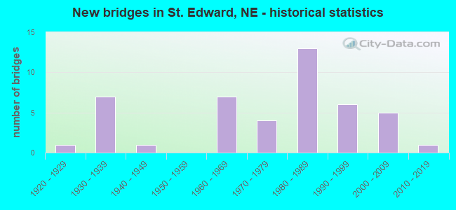
- New bridges - historical statistics
- 11920-1929
- 71930-1939
- 11940-1949
- 71960-1969
- 41970-1979
- 131980-1989
- 61990-1999
- 52000-2009
- 12010-2019

- Bridge Condition - Deck
- 17.1%Very good
- 34.1%Good
- 7.3%Satisfactory
- 41.5%Fair

- Bridge Condition - Superstructure
- 4.9%Excellent
- 41.5%Very good
- 41.5%Good
- 2.4%Satisfactory
- 9.8%Fair

- Bridge Condition - Substructure
- 4.9%Excellent
- 17.1%Very good
- 46.3%Good
- 19.5%Satisfactory
- 9.8%Fair
- 2.4%Poor

- Bridge Condition - Channel
- 4.4%Excellent
- 22.2%Very good
- 26.7%Good
- 28.9%Satisfactory
- 17.8%Fair

- Bridge Condition - Culverts
- 25.0%Very good
- 75.0%Good
Find on map >> Show street view
Structure Number: S039 03222, Location: 1W ST EDWARD (Lat: 41.569200, Lng: -97.872200), Route carried "on" structure: State highway 39, Year Built: 1981, Status: Open, Structure Length: 1.65m (5.41ft), Average Daily Traffic: 2,265 (year 2018), Truck Traffic: 13%, Average Future Daily Traffic: 2,945 (year 2038), Design Load: HS 20, Features Intersected: STREAM
Minimum Vertical Clearance: 30+ m (98+ ft), Kilometerpoint: 5.185, Lanes on structure: 2, Base Highway Network: Yes, Owner: State Highway Agency, Approaching Roadway Width: 12.2m (40.0ft), Skew: 4 degrees, Material/Design: Concrete, Design/Construction: Culvert, Number Of Spans In Main Unit: 4, Length of Maximum Span: 3.0m (9.8ft)
Condition: Channel: Fair, Culverts: Good, Operating Rating: 43.0 metric tons, Method Used To Determine Operating Rating: Field evaluation and documented engineering judgment, Inventory Rating: 33.0 metric tons, Method Used To Determine Inventory Rating: Field evaluation and documented engineering judgment, Structural Evaluation: Better than present minimum criteria, Waterway Adequacy: Somewhat better than minimum adequacy, Approach Roadway Alignment: Equal to present desirable criteria, Designated Inspection Frequency: Every 24 months, Inspection Date: May 2021
Find on map >> Show street view
Structure Number: S056 03349, Location: 3W ST. EDWARD (Lat: 41.568500, Lng: -97.918700), Route carried "on" structure: State highway 56, Year Built: 1963, Status: Open, Structure Length: 1.95m (6.40ft), Average Daily Traffic: 545 (year 2018), Truck Traffic: 12%, Average Future Daily Traffic: 681 (year 2038), Design Load: HS 20, Features Intersected: BOGUS CREEK
Minimum Vertical Clearance: 30+ m (98+ ft), Kilometerpoint: 5.390, Lanes on structure: 2, Owner: State Highway Agency, Approaching Roadway Width: 7.3m (24.0ft), Material/Design: Concrete continuous, Design/Construction: Slab, Number Of Spans In Main Unit: 3, Length of Maximum Span: 7.6m (24.9ft), Curb-To-Curb Width: 10.5m (34.4ft), Out-to-Out Width: 11.7m (38.4ft)
Condition: Deck: Good, Superstructure: Good, Substructure: Good, Channel: Very good, Operating Rating: 51.0 metric tons, Method Used To Determine Operating Rating: Load Factor (LF), Inventory Rating: 31.0 metric tons, Method Used To Determine Inventory Rating: Load Factor (LF), Structural Evaluation: Better than present minimum criteria, Deck Geometry: Equal to present minimum criteria, Waterway Adequacy: Equal to present desirable criteria, Approach Roadway Alignment: Equal to present desirable criteria, Designated Inspection Frequency: Every 24 months, Inspection Date: June 2021, Deck Structure Type: Concrete Cast-file-Place, Wearing Surface/Protective System: Wearing Surface: Bituminous, Membrane: Preformed Fabric