Bridge Statistics for St. Johnsbury, Vermont (VT)
Condition, Traffic, Stress, Structural Evaluation, Project Costs
- National Bridge Inventory (NBI) Statistics
- 52Number of bridges
- 771ft / 235mTotal length
- $40,125,000Total costs
- 262,080Total average daily traffic
- 29,785Total average daily truck traffic
- National Bridge Inventory (NBI) Registered Bridges for St. Johnsbury
- No street view available for this location
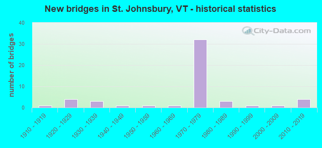
- New bridges - historical statistics
- 11910-1919
- 41920-1929
- 31930-1939
- 11940-1949
- 11950-1959
- 11960-1969
- 321970-1979
- 31980-1989
- 11990-1999
- 12000-2009
- 42010-2019
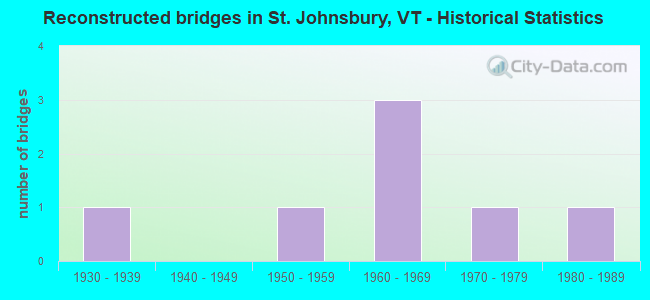
- Reconstructed bridges - Historical Statistics
- 11930-1939
- 01940-1949
- 11950-1959
- 31960-1969
- 11970-1979
- 11980-1989
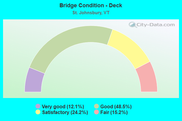
- Bridge Condition - Deck
- 12.1%Very good
- 48.5%Good
- 24.2%Satisfactory
- 15.2%Fair
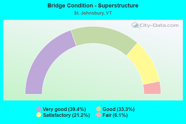
- Bridge Condition - Superstructure
- 39.4%Very good
- 33.3%Good
- 21.2%Satisfactory
- 6.1%Fair
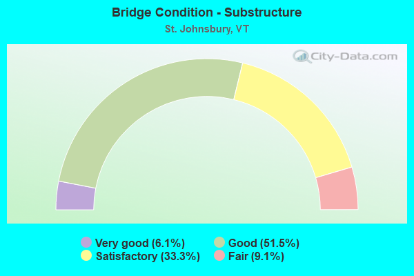
- Bridge Condition - Substructure
- 6.1%Very good
- 51.5%Good
- 33.3%Satisfactory
- 9.1%Fair
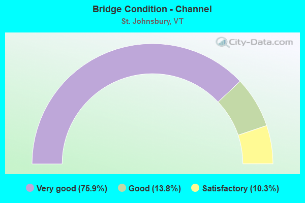
- Bridge Condition - Channel
- 75.9%Very good
- 13.8%Good
- 10.3%Satisfactory
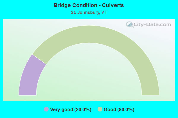
- Bridge Condition - Culverts
- 20.0%Very good
- 80.0%Good
Find on map >> Show street view
Structure Number: 207012001903112, Location: CONCORD AVE (Lat: 44.423536, Lng: -72.009067), Route carried "on" structure: City street CONCD, Year Built: 1933, Year Reconstructed: 1971, Status: Open, Structure Length: 2.26m (7.41ft), Average Daily Traffic: 4,300 (year 2016), Truck Traffic: 11%, Average Future Daily Traffic: 4,515 (year 2026), Design Load: H 20, Features Intersected: MOOSE RIVER
Minimum Vertical Clearance: 30+ m (98+ ft), Kilometerpoint: 0.000, Lanes on structure: 2, Owner: City or Municipal Highway Agency, Approaching Roadway Width: 7.3m (24.0ft), Material/Design: Steel, Design/Construction: Stringer/Multi-beam, Number Of Spans In Main Unit: 1, Length of Maximum Span: 21.9m (71.9ft), Curb or Sidewalk Widths: Left: 1.2m (3.9ft), Right: 0.2m (0.7ft), Curb-To-Curb Width: 8.4m (27.6ft), Out-to-Out Width: 8.7m (28.5ft)
Condition: Deck: Satisfactory, Superstructure: Good, Substructure: Satisfactory, Channel: Very good, Operating Rating: 39.9 metric tons, Method Used To Determine Operating Rating: Load Factor (LF), Inventory Rating: 23.6 metric tons, Method Used To Determine Inventory Rating: Load Factor (LF), Structural Evaluation: Equal to present minimum criteria, Deck Geometry: High priority of corrective action, Waterway Adequacy: Better than present minimum criteria, Approach Roadway Alignment: Equal to present desirable criteria, Length Of Structure Improvement: 2.26m (7.41ft), Designated Inspection Frequency: Every 24 months, Inspection Date: July 2020, Bridge Improvement Cost: $741,000, Roadway Improvement Cost: $50,000, Total Project Cost: $791,000 ( Estimate for 2020), Deck Structure Type: Concrete Cast-file-Place, Wearing Surface/Protective System: Wearing Surface: Bituminous, Membrane: Preformed Fabric
Find on map >> Show street view
Structure Number: 207020003603112, Location: LOWER PORTLAND STREET (Lat: 44.419844, Lng: -72.012903), Route carried "on" structure: City street LPRTS, Year Built: 1963, Status: Open, Structure Length: 4.72m (15.49ft), Average Daily Traffic: 600 (year 2016), Truck Traffic: 3%, Average Future Daily Traffic: 630 (year 2026), Design Load: H 20, Features Intersected: PASSUMPSIC RIVER
Minimum Vertical Clearance: 30+ m (98+ ft), Kilometerpoint: 0.000, Lanes on structure: 2, Owner: City or Municipal Highway Agency, Approaching Roadway Width: 6.7m (22.0ft), Material/Design: Steel continuous, Design/Construction: Stringer/Multi-beam, Number Of Spans In Main Unit: 2, Length of Maximum Span: 22.6m (74.1ft), Curb or Sidewalk Widths: Left: 0.5m (1.6ft), Right: 1.5m (4.9ft), Curb-To-Curb Width: 6.7m (22.0ft), Out-to-Out Width: 9.3m (30.5ft)
Condition: Deck: Satisfactory, Superstructure: Satisfactory, Substructure: Good, Channel: Very good, Operating Rating: 49.0 metric tons, Method Used To Determine Operating Rating: Allowable Stress (AS), Inventory Rating: 24.5 metric tons, Method Used To Determine Inventory Rating: Allowable Stress (AS), Structural Evaluation: Equal to present minimum criteria, Deck Geometry: Meets minimum limits, Waterway Adequacy: Better than present minimum criteria, Approach Roadway Alignment: Equal to present desirable criteria, Length Of Structure Improvement: 4.72m (15.49ft), Designated Inspection Frequency: Every 24 months, Underwater Inspection Frequency: Every 48 months, Inspection Date: July 2020, Underwater Inspection Date: August 2021, Bridge Improvement Cost: $1,655,000, Roadway Improvement Cost: $50,000, Total Project Cost: $1,705,000 ( Estimate for 2020), Deck Structure Type: Concrete Cast-file-Place, Wearing Surface/Protective System: Wearing Surface: Bituminous
Find on map >> Show street view
Structure Number: 100311004103111, Location: 0.07 MI W TO JCT W TH70 (Lat: 44.417172, Lng: -72.029864), Route carried "under" structure: Other road C3068, Year Built: 2013, Structure Length: 0. m, Average Daily Traffic: 110 (year 2009), Truck Traffic: 1%, Features Intersected: VAST TRAIL OVER TH68, Facility Carried by Structure: PED/BIKE PATH
Kilometerpoint: 0.000, Material/Design: Steel, Design/Construction: Truss - Thru, Length of Maximum Span: 21.9m (71.9ft)
Find on map >> Show street view
Structure Number: 200028103E03112, Location: 0.5 MI N JCT VT 2B W (Lat: 44.428031, Lng: -72.033717), Route carried "under" structure: Interstate 91, Year Built: 1975, Structure Length: 0. m, Average Daily Traffic: 3,000 (year 1998), Truck Traffic: 13%, Features Intersected: I 91 UNDER US 2, Facility Carried by Structure: US 00002 E ML
Minimum Vertical Clearance: 6.40m (21.00ft), Kilometerpoint: 210.184, Lanes on structure: 3, Material/Design: Steel continuous, Design/Construction: Stringer/Multi-beam, Length of Maximum Span: 48.8m (160.1ft)
Find on map >> Show street view
Structure Number: 200028103W03112, Location: 0.5 MI N JCT VT 2B W (Lat: 44.428353, Lng: -72.033819), Route carried "under" structure: Interstate 91, Year Built: 1975, Structure Length: 0. m, Average Daily Traffic: 3,000 (year 1998), Truck Traffic: 13%, Features Intersected: I 91 UNDER US 2, Facility Carried by Structure: US 00002 W ML
Minimum Vertical Clearance: 7.18m (23.56ft), Kilometerpoint: 210.184, Lanes on structure: 3, Material/Design: Steel continuous, Design/Construction: Stringer/Multi-beam, Length of Maximum Span: 48.8m (160.1ft)
Find on map >> Show street view
Structure Number: 200041003A03112, Location: I 91 EXIT 22 (Lat: 44.453811, Lng: -72.024306), Route carried "under" structure: Interstate 91, Year Built: 1975, Structure Length: 0. m, Average Daily Traffic: 3,750 (year 1998), Truck Traffic: 13%, Features Intersected: VT973 CONN. OVER I 91NB, Facility Carried by Structure: VT 00973 CONN
Minimum Vertical Clearance: 5.79m (19.00ft), Kilometerpoint: 213.305, Lanes on structure: 2, Material/Design: Steel, Design/Construction: Stringer/Multi-beam, Length of Maximum Span: 32.3m (106.0ft)
Find on map >> Show street view
Structure Number: 200091083N03112, Location: I 91 EXIT 20 (Lat: 44.404942, Lng: -72.022683), Route carried "under" structure: US 5, Year Built: 1978, Structure Length: 0. m, Average Daily Traffic: 3,750 (year 1998), Truck Traffic: 11%, Features Intersected: I 91 OVER US 5, Facility Carried by Structure: I 00091 ML
Minimum Vertical Clearance: 5.15m (16.90ft), Kilometerpoint: 219.604, Material/Design: Steel continuous, Design/Construction: Stringer/Multi-beam, Length of Maximum Span: 34.1m (111.9ft)
Find on map >> Show street view
Structure Number: 200091083S03112, Location: I 91 EXIT 20 (Lat: 44.404600, Lng: -72.022864), Route carried "under" structure: US 5, Year Built: 1978, Structure Length: 0. m, Average Daily Traffic: 3,750 (year 1998), Truck Traffic: 11%, Features Intersected: I 91 OVER US 5, Facility Carried by Structure: I 00091 ML
Minimum Vertical Clearance: 5.00m (16.40ft), Kilometerpoint: 219.604, Lanes on structure: 3, Material/Design: Steel continuous, Design/Construction: Stringer/Multi-beam, Length of Maximum Span: 34.1m (111.9ft)
Find on map >> Show street view
Structure Number: 200091090S03112, Location: I 91 EXIT 22 (Lat: 44.453808, Lng: -72.025103), Route carried "under" structure: Ramp State highway 973, Year Built: 1975, Structure Length: 0. m, Average Daily Traffic: 4,200 (year 1996), Truck Traffic: 6%, Features Intersected: I 91SB OVER VT973 - CONN, Facility Carried by Structure: I 00091 ML
Minimum Vertical Clearance: 4.80m (15.75ft), Kilometerpoint: 1.609, Lanes on structure: 2, Material/Design: Steel, Design/Construction: Stringer/Multi-beam, Length of Maximum Span: 24.4m (80.1ft)
Find on map >> Show street view
Structure Number: 2003110D8903111, Location: 0.7 MI N EXIT 21 (Lat: 44.438289, Lng: -72.027739), Route carried "under" structure: Interstate 91, Year Built: 1975, Structure Length: 0. m, Average Daily Traffic: 7,500 (year 1998), Truck Traffic: 13%, Features Intersected: I 91 UNDER TH NO 4, Facility Carried by Structure: TR 00TH4
Minimum Vertical Clearance: 6.95m (22.80ft), Kilometerpoint: 211.503, Lanes on structure: 2, Material/Design: Steel continuous, Design/Construction: Stringer/Multi-beam, Length of Maximum Span: 33.5m (109.9ft)
Find on map >> Show street view
Structure Number: 207000000703112, Location: 0.2 MI W JCT US2 E (Lat: 44.420992, Lng: -72.032586), Route carried "under" structure: Interstate 91, Year Built: 1975, Structure Length: 0. m, Average Daily Traffic: 6,000 (year 1998), Truck Traffic: 13%, Features Intersected: I 91 UNDER VT 2B, Facility Carried by Structure: VT 0002B ML
Minimum Vertical Clearance: 11.58m (37.99ft), Kilometerpoint: 209.331, Lanes on structure: 2, Material/Design: Steel continuous, Design/Construction: Stringer/Multi-beam, Length of Maximum Span: 55.5m (182.1ft)