Bridge Statistics for St. Petersburg, Florida (FL)
Condition, Traffic, Stress, Structural Evaluation, Project Costs
- National Bridge Inventory (NBI) Statistics
- 336Number of bridges
- 8,323ft / 2,537mTotal length
- $3,470,000Total costs
- 6,864,859Total average daily traffic
- 387,824Total average daily truck traffic
- National Bridge Inventory (NBI) Registered Bridges for St. Petersburg
- No street view available for this location
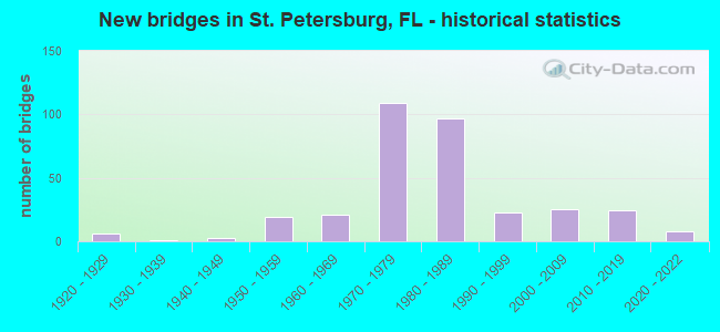
- New bridges - historical statistics
- 61920-1929
- 11930-1939
- 31940-1949
- 191950-1959
- 211960-1969
- 1091970-1979
- 971980-1989
- 231990-1999
- 252000-2009
- 242010-2019
- 82020-2022

- Reconstructed bridges - Historical Statistics
- 41980-1989
- 111990-1999
- 02000-2009
- 12010-2019


- Bridge Condition - Deck
- 11.5%Very good
- 68.2%Good
- 12.8%Satisfactory
- 4.1%Fair
- 2.7%Poor
- 0.7%Serious

- Bridge Condition - Superstructure
- 7.4%Very good
- 74.5%Good
- 7.4%Satisfactory
- 6.7%Fair
- 3.4%Poor
- 0.7%Serious

- Bridge Condition - Substructure
- 12.1%Very good
- 69.1%Good
- 14.1%Satisfactory
- 4.7%Fair

- Bridge Condition - Channel
- 14.4%Excellent
- 10.6%Very good
- 52.9%Good
- 20.2%Satisfactory
- 1.9%Fair
- 1.0%Poor

- Bridge Condition - Culverts
- 2.8%Very good
- 58.3%Good
- 22.2%Satisfactory
- 5.6%Fair
- 8.3%Poor
- 2.8%Serious
Find on map >> Show street view
Structure Number: 157238, Location: AT 77TH AVE NORTH (Lat: 27.842944, Lng: -82.655056), Route carried "on" structure: City street , Year Built: 1978, Status: Open, Structure Length: 1.63m (5.35ft), Average Daily Traffic: 1,900 (year 2020), Truck Traffic: 4%, Average Future Daily Traffic: 3,297 (year 2042), Design Load: HS 20, Features Intersected: CANAL 12, Facility Carried by Structure: 16TH ST NORTH
Minimum Vertical Clearance: 30+ m (98+ ft), Kilometerpoint: 1.638, Lanes on structure: 3, Owner: City or Municipal Highway Agency, Approaching Roadway Width: 11.6m (38.1ft), Material/Design: Prestressed concrete, Design/Construction: Slab, Number Of Spans In Main Unit: 2, Length of Maximum Span: 8.2m (26.9ft), Curb or Sidewalk Widths: Left: 1.1m (3.6ft), Right: 1.1m (3.6ft), Curb-To-Curb Width: 11.6m (38.1ft), Out-to-Out Width: 14.7m (48.2ft)
Condition: Deck: Good, Superstructure: Good, Substructure: Good, Channel: Good, Operating Rating: 32.7 metric tons, Method Used To Determine Operating Rating: Load Testing, Inventory Rating: 23.9 metric tons, Method Used To Determine Inventory Rating: Load Testing, Structural Evaluation: Equal to present minimum criteria, Deck Geometry: High priority of replacement, Waterway Adequacy: Equal to present minimum criteria, Approach Roadway Alignment: Equal to present desirable criteria, Designated Inspection Frequency: Every 24 months, Underwater Inspection Frequency: Every 24 months, Inspection Date: July 2021, Underwater Inspection Date: June 2021, Deck Structure Type: Concrete Precast Panels, Wearing Surface/Protective System: Wearing Surface: Bituminous
Find on map >> Show street view
Structure Number: 157239, Location: AT 77TH AVENUE NORTH (Lat: 27.842417, Lng: -82.655206), Route carried "on" structure: City street , Year Built: 1978, Status: Open, Structure Length: 0.98m (3.22ft), Average Daily Traffic: 16,500 (year 2020), Truck Traffic: 6%, Average Future Daily Traffic: 28,628 (year 2042), Design Load: HS 20, Features Intersected: CANAL 10, Facility Carried by Structure: 16TH ST. N SB
Minimum Vertical Clearance: 30+ m (98+ ft), Kilometerpoint: 1.547, Lanes on structure: 1, Owner: City or Municipal Highway Agency, Approaching Roadway Width: 4.8m (15.7ft), Skew: 3 degrees, Material/Design: Prestressed concrete, Design/Construction: Slab, Number Of Spans In Main Unit: 1, Length of Maximum Span: 9.8m (32.2ft), Curb-To-Curb Width: 4.8m (15.7ft), Out-to-Out Width: 5.4m (17.7ft)
Condition: Deck: Good, Superstructure: Good, Substructure: Good, Channel: Excellent, Operating Rating: 52.9 metric tons, Method Used To Determine Operating Rating: Load Factor (LF), Inventory Rating: 30.5 metric tons, Method Used To Determine Inventory Rating: Load Factor (LF), Structural Evaluation: Better than present minimum criteria, Deck Geometry: High priority of corrective action, Waterway Adequacy: Equal to present minimum criteria, Approach Roadway Alignment: Better than present minimum criteria, Designated Inspection Frequency: Every 24 months, Inspection Date: July 2021, Deck Structure Type: Concrete Precast Panels, Wearing Surface/Protective System: Wearing Surface: Bituminous
Find on map >> Show street view
Structure Number: 157263, Location: 180FT. N OF 45TH AVE N (Lat: 27.813514, Lng: -82.634442), Route carried "on" structure: City street , Year Built: 1960, Year Reconstructed: 1998, Status: Open, Structure Length: 1.62m (5.31ft), Average Daily Traffic: 3,500 (year 2020), Truck Traffic: 4%, Average Future Daily Traffic: 6,073 (year 2042), Design Load: HS 20, Features Intersected: LOW HEAD CANAL, Facility Carried by Structure: 1ST ST. NORTH
Minimum Vertical Clearance: 30+ m (98+ ft), Kilometerpoint: 2.366, Lanes on structure: 4, Owner: City or Municipal Highway Agency, Approaching Roadway Width: 13.4m (44.0ft), Skew: 9 degrees, Material/Design: Concrete, Design/Construction: Culvert, Number Of Spans In Main Unit: 4, Length of Maximum Span: 4.5m (14.8ft)
Condition: Channel: Satisfactory, Culverts: Satisfactory, Operating Rating: 66.8 metric tons, Method Used To Determine Operating Rating: Load Factor (LF), Inventory Rating: 40.0 metric tons, Method Used To Determine Inventory Rating: Load Factor (LF), Structural Evaluation: Equal to present minimum criteria, Waterway Adequacy: Equal to present desirable criteria, Approach Roadway Alignment: Equal to present desirable criteria, Designated Inspection Frequency: Every 24 months, Underwater Inspection Frequency: Every 24 months, Inspection Date: July 2021, Underwater Inspection Date: June 2021
Find on map >> Show street view
Structure Number: 157264, Location: 150FT N OF 45TH AVE N (Lat: 27.813339, Lng: -82.634447), Route carried "on" structure: City street , Year Built: 1998, Status: Open, Structure Length: 0.67m (2.20ft), Average Daily Traffic: 3,500 (year 2020), Truck Traffic: 4%, Average Future Daily Traffic: 6,073 (year 2042), Design Load: HS 20, Features Intersected: LOW HEAD CANAL, Facility Carried by Structure: 1ST ST NORTH
Minimum Vertical Clearance: 30+ m (98+ ft), Kilometerpoint: 2.350, Lanes on structure: 4, Owner: City or Municipal Highway Agency, Approaching Roadway Width: 13.4m (44.0ft), Skew: 9 degrees, Material/Design: Concrete, Design/Construction: Culvert, Number Of Spans In Main Unit: 2, Length of Maximum Span: 3.3m (10.8ft)
Condition: Channel: Good, Culverts: Good, Operating Rating: 84.9 metric tons, Method Used To Determine Operating Rating: Load Factor (LF), Inventory Rating: 51.0 metric tons, Method Used To Determine Inventory Rating: Load Factor (LF), Structural Evaluation: Better than present minimum criteria, Waterway Adequacy: Equal to present desirable criteria, Approach Roadway Alignment: Equal to present desirable criteria, Designated Inspection Frequency: Every 24 months, Underwater Inspection Frequency: Every 24 months, Inspection Date: July 2021, Underwater Inspection Date: June 2021
Find on map >> Show street view
Structure Number: 157265, Location: 0.5MI S OF SNELL ISLE BLV (Lat: 27.792222, Lng: -82.615792), Route carried "on" structure: City street , Year Built: 2004, Status: Open, Structure Length: 0.94m (3.08ft), Average Daily Traffic: 229 (year 2021), Truck Traffic: 1%, Average Future Daily Traffic: 397 (year 2042), Design Load: HL 93, Features Intersected: APPIAN CANAL, Facility Carried by Structure: APPIAN WAY NE
Minimum Vertical Clearance: 4.79m (15.72ft), Kilometerpoint: 0.000, Lanes on structure: 2, Owner: City or Municipal Highway Agency, Approaching Roadway Width: 7.3m (24.0ft), Material/Design: Concrete, Design/Construction: Slab, Number Of Spans In Main Unit: 1, Length of Maximum Span: 9.4m (30.8ft), Curb or Sidewalk Widths: Left: 1.5m (4.9ft), Right: 1.5m (4.9ft), Curb-To-Curb Width: 7.3m (24.0ft), Out-to-Out Width: 11.0m (36.1ft)
Condition: Deck: Good, Superstructure: Good, Substructure: Good, Channel: Very good, Inventory Rating: 59.2 metric tons, Method Used To Determine Inventory Rating: Load Factor (LF), Structural Evaluation: Better than present minimum criteria, Deck Geometry: Somewhat better than minimum adequacy, Waterway Adequacy: Equal to present desirable criteria, Approach Roadway Alignment: Equal to present desirable criteria, Designated Inspection Frequency: Every 24 months, Inspection Date: July 2021, Deck Structure Type: Concrete Cast-file-Place
Find on map >> Show street view
Structure Number: 157266, Location: 142ft. W/O 4th. St. N. (Lat: 27.821147, Lng: -82.639122), Route carried "on" structure: City street , Year Built: 1977, Status: Open, Structure Length: 0.81m (2.66ft), Average Daily Traffic: 19,500 (year 2020), Truck Traffic: 3%, Average Future Daily Traffic: 24,375 (year 2042), Design Load: H 15, Features Intersected: N/A, Facility Carried by Structure: 54th Ave. N.
Minimum Vertical Clearance: 30+ m (98+ ft), Kilometerpoint: 0.000, Lanes on structure: 4, Owner: County Highway Agency, Approaching Roadway Width: 24.7m (81.0ft), Material/Design: Concrete, Design/Construction: Culvert, Number Of Spans In Main Unit: 3, Length of Maximum Span: 2.4m (7.9ft)
Condition: Channel: Satisfactory, Culverts: Good, Operating Rating: 64.7 metric tons, Method Used To Determine Operating Rating: Load and Resistance Factor (LRFR), Inventory Rating: 49.6 metric tons, Method Used To Determine Inventory Rating: Load and Resistance Factor (LRFR), Structural Evaluation: Better than present minimum criteria, Waterway Adequacy: Equal to present desirable criteria, Approach Roadway Alignment: Equal to present desirable criteria, Designated Inspection Frequency: Every 24 months, Underwater Inspection Frequency: Every 24 months, Inspection Date: April 2021, Underwater Inspection Date: March 2021
Find on map >> Show street view
Structure Number: 157267, Location: 128FT. E/O 54 Ave. N (Lat: 27.821119, Lng: -82.638053), Route carried "on" structure: City street , Year Built: 1979, Status: Open, Structure Length: 0.81m (2.66ft), Average Daily Traffic: 19,500 (year 2020), Truck Traffic: 3%, Average Future Daily Traffic: 24,375 (year 2042), Design Load: HS 20, Features Intersected: N/A, Facility Carried by Structure: 4TH. ST. N.
Minimum Vertical Clearance: 30+ m (98+ ft), Kilometerpoint: 0.000, Lanes on structure: 6, Owner: County Highway Agency, Approaching Roadway Width: 24.7m (81.0ft), Material/Design: Concrete, Design/Construction: Culvert, Number Of Spans In Main Unit: 3, Length of Maximum Span: 3.0m (9.8ft)
Condition: Channel: Very good, Culverts: Good, Operating Rating: 41.5 metric tons, Method Used To Determine Operating Rating: Load and Resistance Factor (LRFR), Inventory Rating: 32.0 metric tons, Method Used To Determine Inventory Rating: Load and Resistance Factor (LRFR), Structural Evaluation: Better than present minimum criteria, Waterway Adequacy: Equal to present desirable criteria, Approach Roadway Alignment: Equal to present desirable criteria, Designated Inspection Frequency: Every 24 months, Underwater Inspection Frequency: Every 24 months, Inspection Date: April 2021, Underwater Inspection Date: March 2021
Find on map >> Show street view
Structure Number: 157302, Location: 200FT. S OF 22ND AVE. S (Lat: 27.747856, Lng: -82.685403), Route carried "on" structure: City street , Year Built: 1940, Status: Open, Structure Length: 0.70m (2.30ft), Average Daily Traffic: 404 (year 2021), Truck Traffic: 2%, Average Future Daily Traffic: 701 (year 2042), Features Intersected: MINNOW CANAL, Facility Carried by Structure: 38TH ST. SOUTH
Minimum Vertical Clearance: 30+ m (98+ ft), Kilometerpoint: 0.340, Lanes on structure: 2, Owner: City or Municipal Highway Agency, Approaching Roadway Width: 6.5m (21.3ft), Material/Design: Concrete, Design/Construction: Culvert, Number Of Spans In Main Unit: 2, Length of Maximum Span: 3.4m (11.2ft)
Condition: Channel: Good, Culverts: Poor, Operating Rating: 65.9 metric tons, Method Used To Determine Operating Rating: Load Factor (LF), Inventory Rating: 39.5 metric tons, Method Used To Determine Inventory Rating: Load Factor (LF), Structural Evaluation: Meets minimum limits, Waterway Adequacy: Better than present minimum criteria, Approach Roadway Alignment: Equal to present desirable criteria, Designated Inspection Frequency: Every 24 months, Other Special Inspection Frequency: Every 12 months, Inspection Date: May 2021, Other Special Inspection Date: May 2021
Find on map >> Show street view
Structure Number: 157317, Location: AT 12TH AVE. SOUTH (Lat: 27.758147, Lng: -82.683339), Route carried "on" structure: City street , Year Built: 1960, Status: Open, Structure Length: 0.64m (2.10ft), Average Daily Traffic: 22,000 (year 2020), Truck Traffic: 3%, Average Future Daily Traffic: 38,170 (year 2042), Features Intersected: JESSE'S CANAL, Facility Carried by Structure: 37TH ST. SOUTH
Minimum Vertical Clearance: 30+ m (98+ ft), Kilometerpoint: 1.513, Lanes on structure: 2, Owner: City or Municipal Highway Agency, Approaching Roadway Width: 9.8m (32.2ft), Material/Design: Concrete, Design/Construction: Culvert, Number Of Spans In Main Unit: 2, Length of Maximum Span: 3.1m (10.2ft)
Condition: Channel: Good, Culverts: Satisfactory, Operating Rating: 87.5 metric tons, Method Used To Determine Operating Rating: Load Factor (LF), Inventory Rating: 52.5 metric tons, Method Used To Determine Inventory Rating: Load Factor (LF), Structural Evaluation: Equal to present minimum criteria, Waterway Adequacy: Equal to present desirable criteria, Approach Roadway Alignment: Equal to present desirable criteria, Designated Inspection Frequency: Every 24 months, Inspection Date: May 2021
Find on map >> Show street view
Structure Number: 157367, Location: 0.1 MI N OF 1ST AVE N (Lat: 27.773583, Lng: -82.712222), Route carried "on" structure: City street , Year Built: 1959, Status: Open, Structure Length: 0.90m (2.95ft), Average Daily Traffic: 13,900 (year 2020), Truck Traffic: 4%, Average Future Daily Traffic: 24,117 (year 2042), Design Load: H 15, Features Intersected: BEAR CREEK, Facility Carried by Structure: 58TH ST NORTH
Minimum Vertical Clearance: 30+ m (98+ ft), Kilometerpoint: 0.303, Lanes on structure: 4, Owner: City or Municipal Highway Agency, Approaching Roadway Width: 14.9m (48.9ft), Skew: 9 degrees, Material/Design: Concrete, Design/Construction: Culvert, Number Of Spans In Main Unit: 3, Length of Maximum Span: 3.0m (9.8ft)
Condition: Channel: Fair, Culverts: Fair, Operating Rating: 26.5 metric tons, Method Used To Determine Operating Rating: Load Factor (LF), Inventory Rating: 15.9 metric tons, Method Used To Determine Inventory Rating: Load Factor (LF), Structural Evaluation: High priority of corrective action, Waterway Adequacy: Better than present minimum criteria, Approach Roadway Alignment: Equal to present desirable criteria, Designated Inspection Frequency: Every 24 months, Inspection Date: July 2021
Find on map >> Show street view
Structure Number: 157401, Location: 54TH AVE N & 1ST ST N (Lat: 27.821206, Lng: -82.634536), Route carried "on" structure: City street , Year Built: 1965, Year Reconstructed: 1980, Status: Open, Structure Length: 0.98m (3.22ft), Average Daily Traffic: 3,500 (year 2020), Truck Traffic: 4%, Average Future Daily Traffic: 6,073 (year 2042), Features Intersected: PLACIDO BAYOU, Facility Carried by Structure: 1ST ST N & 54 AV N
Minimum Vertical Clearance: 30+ m (98+ ft), Kilometerpoint: 2.424, Lanes on structure: 4, Owner: City or Municipal Highway Agency, Approaching Roadway Width: 15.2m (49.9ft), Material/Design: Concrete, Design/Construction: Culvert, Number Of Spans In Main Unit: 1, Length of Maximum Span: 9.8m (32.2ft)
Condition: Channel: Good, Culverts: Fair, Operating Rating: 53.3 metric tons, Method Used To Determine Operating Rating: Load Factor (LF), Inventory Rating: 29.6 metric tons, Method Used To Determine Inventory Rating: Load Factor (LF), Structural Evaluation: Somewhat better than minimum adequacy, Waterway Adequacy: Equal to present minimum criteria, Approach Roadway Alignment: Equal to present desirable criteria, Designated Inspection Frequency: Every 24 months, Underwater Inspection Frequency: Every 24 months, Inspection Date: July 2021, Underwater Inspection Date: June 2021, Deck Structure Type: Concrete Precast Panels, Wearing Surface/Protective System: Wearing Surface: Bituminous
Find on map >> Show street view
Structure Number: 157402, Location: AT 58TH ST N (Lat: 27.798994, Lng: -82.712286), Route carried "on" structure: City street , Year Built: 1983, Status: Open, Structure Length: 1.23m (4.04ft), Average Daily Traffic: 4,900 (year 2020), Truck Traffic: 4%, Average Future Daily Traffic: 8,502 (year 2042), Design Load: HS 20, Features Intersected: 58TH ST CANAL, Facility Carried by Structure: 30TH AVE NORTH
Minimum Vertical Clearance: 30.45m (99.90ft), Kilometerpoint: 1.595, Lanes on structure: 2, Owner: City or Municipal Highway Agency, Approaching Roadway Width: 14.7m (48.2ft), Material/Design: Prestressed concrete, Design/Construction: Slab, Number Of Spans In Main Unit: 1, Length of Maximum Span: 12.3m (40.4ft), Curb or Sidewalk Widths: Left: 1.3m (4.3ft), Right: 1.3m (4.3ft), Curb-To-Curb Width: 14.7m (48.2ft), Out-to-Out Width: 18.4m (60.4ft)
Condition: Deck: Good, Superstructure: Good, Substructure: Good, Channel: Excellent, Operating Rating: 52.9 metric tons, Method Used To Determine Operating Rating: Load Factor (LF), Inventory Rating: 32.9 metric tons, Method Used To Determine Inventory Rating: Load Factor (LF), Structural Evaluation: Better than present minimum criteria, Deck Geometry: Superior to present desirable criteria, Waterway Adequacy: Better than present minimum criteria, Approach Roadway Alignment: Equal to present desirable criteria, Designated Inspection Frequency: Every 24 months, Inspection Date: July 2021, Deck Structure Type: Concrete Precast Panels, Wearing Surface/Protective System: Wearing Surface: Bituminous
Find on map >> Show street view
Structure Number: 157403, Location: 0.2MI. S OF 38TH AVE. N (Lat: 27.802700, Lng: -82.712447), Route carried "on" structure: City street , Year Built: 1983, Status: Open, Structure Length: 1.48m (4.86ft), Average Daily Traffic: 6,950 (year 2020), Truck Traffic: 4%, Average Future Daily Traffic: 12,059 (year 2042), Design Load: HS 20, Features Intersected: MILES PINE CREEK, Facility Carried by Structure: 58TH ST. NORTH SB
Minimum Vertical Clearance: 30+ m (98+ ft), Kilometerpoint: 3.513, Lanes on structure: 2, Owner: City or Municipal Highway Agency, Approaching Roadway Width: 8.8m (28.9ft), Material/Design: Prestressed concrete, Design/Construction: Slab, Number Of Spans In Main Unit: 2, Length of Maximum Span: 7.3m (24.0ft), Curb or Sidewalk Widths: Left: 1.6m (5.2ft), Right: 0.0m, Curb-To-Curb Width: 9.2m (30.2ft), Out-to-Out Width: 11.7m (38.4ft)
Condition: Deck: Good, Superstructure: Good, Substructure: Good, Channel: Satisfactory, Operating Rating: 45.3 metric tons, Method Used To Determine Operating Rating: Load Factor (LF), Inventory Rating: 27.1 metric tons, Method Used To Determine Inventory Rating: Load Factor (LF), Structural Evaluation: Equal to present minimum criteria, Deck Geometry: Meets minimum limits, Waterway Adequacy: Equal to present minimum criteria, Approach Roadway Alignment: Equal to present desirable criteria, Designated Inspection Frequency: Every 24 months, Inspection Date: July 2021, Deck Structure Type: Concrete Precast Panels, Wearing Surface/Protective System: Wearing Surface: Epoxy Overlay
Find on map >> Show street view
Structure Number: 157406, Location: AT 58TH ST N (Lat: 27.795378, Lng: -82.712306), Route carried "on" structure: City street , Year Built: 1983, Status: Open, Structure Length: 1.25m (4.10ft), Average Daily Traffic: 525 (year 2021), Truck Traffic: 5%, Average Future Daily Traffic: 911 (year 2042), Design Load: HS 20, Features Intersected: 58TH ST CANAL, Facility Carried by Structure: 26TH AVE N
Minimum Vertical Clearance: 30.45m (99.90ft), Kilometerpoint: 0.000, Lanes on structure: 2, Owner: City or Municipal Highway Agency, Approaching Roadway Width: 14.7m (48.2ft), Material/Design: Prestressed concrete, Design/Construction: Slab, Number Of Spans In Main Unit: 1, Length of Maximum Span: 12.5m (41.0ft), Curb or Sidewalk Widths: Left: 1.3m (4.3ft), Right: 1.3m (4.3ft), Curb-To-Curb Width: 14.7m (48.2ft), Out-to-Out Width: 18.4m (60.4ft)
Condition: Deck: Good, Superstructure: Good, Substructure: Good, Channel: Good, Operating Rating: 54.2 metric tons, Method Used To Determine Operating Rating: Load Factor (LF), Inventory Rating: 32.5 metric tons, Method Used To Determine Inventory Rating: Load Factor (LF), Structural Evaluation: Better than present minimum criteria, Deck Geometry: Superior to present desirable criteria, Waterway Adequacy: Equal to present minimum criteria, Approach Roadway Alignment: Equal to present desirable criteria, Designated Inspection Frequency: Every 24 months, Inspection Date: July 2021, Deck Structure Type: Concrete Precast Panels, Wearing Surface/Protective System: Wearing Surface: Bituminous
Find on map >> Show street view
Structure Number: 157407, Location: 520FT W OF 4TH ST S (Lat: 27.748467, Lng: -82.640181), Route carried "on" structure: City street , Year Built: 1986, Status: Open, Structure Length: 0.83m (2.72ft), Average Daily Traffic: 6,800 (year 2020), Truck Traffic: 4%, Average Future Daily Traffic: 11,798 (year 2042), Design Load: HS 20, Features Intersected: SALT CREEK, Facility Carried by Structure: 22ND AVE. SOUTH
Minimum Vertical Clearance: 30+ m (98+ ft), Kilometerpoint: 3.856, Lanes on structure: 4, Owner: City or Municipal Highway Agency, Approaching Roadway Width: 12.5m (41.0ft), Skew: 2 degrees, Material/Design: Concrete, Design/Construction: Culvert, Number Of Spans In Main Unit: 2, Length of Maximum Span: 4.0m (13.1ft), Curb or Sidewalk Widths: Left: 4.0m (13.1ft), Right: 1.5m (4.9ft), Curb-To-Curb Width: 16.8m (55.1ft), Out-to-Out Width: 24.7m (81.0ft)
Condition: Channel: Good, Culverts: Good, Operating Rating: 86.8 metric tons, Method Used To Determine Operating Rating: Load Factor (LF), Inventory Rating: 52.1 metric tons, Method Used To Determine Inventory Rating: Load Factor (LF), Structural Evaluation: Better than present minimum criteria, Deck Geometry: Somewhat better than minimum adequacy, Waterway Adequacy: Equal to present minimum criteria, Approach Roadway Alignment: Equal to present desirable criteria, Designated Inspection Frequency: Every 24 months, Underwater Inspection Frequency: Every 24 months, Inspection Date: May 2021, Underwater Inspection Date: April 2021, Deck Structure Type: Concrete Cast-file-Place
Find on map >> Show street view
Structure Number: 157408, Location: 0.1 MI W OF LEELAND ST (Lat: 27.709556, Lng: -82.697500), Route carried "on" structure: City street , Year Built: 1984, Status: Open, Structure Length: 6.77m (22.21ft), Average Daily Traffic: 495 (year 2021), Truck Traffic: 1%, Average Future Daily Traffic: 859 (year 2042), Design Load: HS 20, Features Intersected: MAXIMO CHANNEL, Facility Carried by Structure: 62ND AVE. SOUTH
Minimum Vertical Clearance: 30+ m (98+ ft), Kilometerpoint: 0.000, Lanes on structure: 2, Owner: City or Municipal Highway Agency, Approaching Roadway Width: 7.3m (24.0ft), Material/Design: Prestressed concrete, Design/Construction: Slab, Number Of Spans In Main Unit: 7, Length of Maximum Span: 10.1m (33.1ft), Curb or Sidewalk Widths: Left: 0.9m (3.0ft), Right: 0.0m, Curb-To-Curb Width: 7.3m (24.0ft), Out-to-Out Width: 9.4m (30.8ft)
Condition: Deck: Serious, Superstructure: Serious, Substructure: Good, Channel: Excellent, Operating Rating: 55.9 metric tons, Method Used To Determine Operating Rating: Load Factor (LF), Inventory Rating: 45.6 metric tons, Method Used To Determine Inventory Rating: Load Factor (LF), Structural Evaluation: High priority of corrective action, Deck Geometry: Meets minimum limits, Waterway Adequacy: Somewhat better than minimum adequacy, Approach Roadway Alignment: Equal to present desirable criteria, Designated Inspection Frequency: Every 24 months, Underwater Inspection Frequency: Every 24 months, Other Special Inspection Frequency: Every 6 months, Inspection Date: May 2021, Underwater Inspection Date: April 2021, Other Special Inspection Date: November 2021, Deck Structure Type: Concrete Precast Panels, Wearing Surface/Protective System: Wearing Surface: Bituminous
Find on map >> Show street view
Structure Number: 157501, Location: PASS-A-GRILLE WAY (Lat: 27.697197, Lng: -82.734894), Route carried "on" structure: City street , Year Built: 1954, Year Reconstructed: 1980, Status: Open, Structure Length: 8.85m (29.04ft), Average Daily Traffic: 3,046 (year 2021), Truck Traffic: 2%, Average Future Daily Traffic: 5,285 (year 2042), Features Intersected: LITTLE McPHERSON BAYOU, Facility Carried by Structure: 21ST AVENUE
Minimum Vertical Clearance: 30+ m (98+ ft), Kilometerpoint: 0.000, Lanes on structure: 2, Owner: City or Municipal Highway Agency, Approaching Roadway Width: 7.3m (24.0ft), Navigation Control: Yes ( Vertical Clearance: 3.6m (11.8ft), Horizontal Clearance: 13.8m (45.3ft)), Material/Design: Prestressed concrete, Design/Construction: Stringer/Multi-beam, Number Of Spans In Main Unit: 6, Length of Maximum Span: 14.6m (47.9ft), Curb or Sidewalk Widths: Left: 1.7m (5.6ft), Right: 1.7m (5.6ft), Curb-To-Curb Width: 7.3m (24.0ft), Out-to-Out Width: 11.4m (37.4ft)
Condition: Deck: Good, Superstructure: Good, Substructure: Satisfactory, Channel: Good, Operating Rating: 53.6 metric tons, Method Used To Determine Operating Rating: Load Factor (LF), Inventory Rating: 32.2 metric tons, Method Used To Determine Inventory Rating: Load Factor (LF), Structural Evaluation: Equal to present minimum criteria, Deck Geometry: High priority of replacement, Waterway Adequacy: Superior to present desirable criteria, Approach Roadway Alignment: Somewhat better than minimum adequacy, Designated Inspection Frequency: Every 24 months, Underwater Inspection Frequency: Every 24 months, Inspection Date: July 2021, Underwater Inspection Date: June 2021, Deck Structure Type: Concrete Cast-file-Place
Find on map >> Show street view
Structure Number: 87448, Location: 1.0 mile E/O SW 107th Av (Lat: 25.522253, Lng: -80.346983), Route carried "on" structure: ServiceCounty highway , Year Built: 1967, Status: Closed, Structure Length: 1.54m (5.05ft), Design Load: HS 20, Features Intersected: Levee L-31E Barrow Canal, Facility Carried by Structure: SW 264th Street
Minimum Vertical Clearance: 30+ m (98+ ft), Kilometerpoint: 0.000, Lanes on structure: 2, Owner: County Highway Agency, Approaching Roadway Width: 6.2m (20.3ft), Material/Design: Prestressed concrete, Design/Construction: Slab, Number Of Spans In Main Unit: 1, Length of Maximum Span: 15.4m (50.5ft), Curb-To-Curb Width: 6.2m (20.3ft), Out-to-Out Width: 6.2m (20.3ft)
Condition: Deck: Poor, Superstructure: Poor, Substructure: Satisfactory, Channel: Poor, Operating Rating: 57.2 metric tons, Method Used To Determine Operating Rating: Load Factor (LF), Inventory Rating: 43.6 metric tons, Method Used To Determine Inventory Rating: Load Factor (LF), Structural Evaluation: Meets minimum limits, Waterway Adequacy: Better than present minimum criteria, Approach Roadway Alignment: Meets minimum limits, Designated Inspection Frequency: Every 24 months, Other Special Inspection Frequency: Every 12 months, Inspection Date: October 2020, Other Special Inspection Date: October 2021, Deck Structure Type: Concrete Precast Panels, Wearing Surface/Protective System: Wearing Surface: Bituminous
Find on map >> Show street view
Structure Number: 150042, Location: 0.7MI NW OF SR-693 (Lat: 27.799222, Lng: -82.737567), Route carried "under" structure: City street , Year Built: 1957, Structure Length: 0. m, Average Daily Traffic: 1,215 (year 2020), Truck Traffic: 1%, Features Intersected: PINELLAS TRAIL, Facility Carried by Structure: ALT US-19 (SR-595)
Minimum Vertical Clearance: 7.65m (25.10ft), Kilometerpoint: 0.898, Lanes on structure: 4, Lanes under structure: 1, Material/Design: Steel continuous, Design/Construction: Stringer/Multi-beam, Length of Maximum Span: 24.3m (79.7ft)
Find on map >> Show street view
Structure Number: 150042, Location: 0.7MI NW OF SR-693 (Lat: 27.799222, Lng: -82.737567), Route carried "under" structure: Other road , Year Built: 1957, Structure Length: 0. m, Features Intersected: PINELLAS TRAIL, Facility Carried by Structure: ALT US-19 (SR-595)
Minimum Vertical Clearance: 7.47m (24.51ft), Kilometerpoint: 0.000, Lanes on structure: 4, Lanes under structure: 2, Material/Design: Steel continuous, Design/Construction: Stringer/Multi-beam, Length of Maximum Span: 24.3m (79.7ft)
Find on map >> Show street view
Structure Number: 150042, Location: 0.7MI NW OF SR-693 (Lat: 27.799222, Lng: -82.737567), Route carried "under" structure: ServiceCity street , Year Built: 1957, Structure Length: 0. m, Average Daily Traffic: 1,007 (year 2020), Truck Traffic: 1%, Features Intersected: PINELLAS TRAIL, Facility Carried by Structure: ALT US-19 (SR-595)
Minimum Vertical Clearance: 6.86m (22.51ft), Kilometerpoint: 1.345, Lanes on structure: 4, Lanes under structure: 1, Material/Design: Steel continuous, Design/Construction: Stringer/Multi-beam, Length of Maximum Span: 24.3m (79.7ft)
Find on map >> Show street view
Structure Number: 150075, Location: I-275NB TO SR-686 WB RAMP (Lat: 27.878206, Lng: -82.658106), Route carried "under" structure: State highway 686, Year Built: 1970, Structure Length: 0. m, Average Daily Traffic: 28,000 (year 2020), Truck Traffic: 6%, Features Intersected: SR 686 (ROOSEVELT BLVD.), Facility Carried by Structure: RAMP P
Minimum Vertical Clearance: 4.60m (15.09ft), Kilometerpoint: 15.086, Lanes on structure: 2, Lanes under structure: 5, Material/Design: Prestressed concrete, Design/Construction: Stringer/Multi-beam, Length of Maximum Span: 27.5m (90.2ft)
Find on map >> Show street view
Structure Number: 150088, Location: 1.5 MI NORTH OF SR-595 (Lat: 27.799250, Lng: -82.662806), Route carried "under" structure: City street , Year Built: 1974, Structure Length: 0. m, Average Daily Traffic: 4,900 (year 2020), Truck Traffic: 4%, Features Intersected: 30TH AVE NORTH, Facility Carried by Structure: I-275 SB
Minimum Vertical Clearance: 5.55m (18.21ft), Kilometerpoint: 6.460, Lanes on structure: 3, Lanes under structure: 3, Material/Design: Prestressed concrete, Design/Construction: Stringer/Multi-beam, Length of Maximum Span: 24.3m (79.7ft)
Find on map >> Show street view
Structure Number: 150089, Location: 1.5MI NORTH OF SR-595 (Lat: 27.799250, Lng: -82.662528), Route carried "under" structure: City street , Year Built: 1974, Structure Length: 0. m, Average Daily Traffic: 4,900 (year 2020), Truck Traffic: 4%, Features Intersected: 30TH AVENUE NORTH, Facility Carried by Structure: I-275 NB
Minimum Vertical Clearance: 4.79m (15.72ft), Kilometerpoint: 6.490, Lanes on structure: 3, Lanes under structure: 2, Material/Design: Prestressed concrete, Design/Construction: Stringer/Multi-beam, Length of Maximum Span: 23.0m (75.5ft)
Find on map >> Show street view
Structure Number: 15009, Location: 4.2 MI S OF GANDY BLVD. (Lat: 27.791967, Lng: -82.660697), Route carried "under" structure: City street , Year Built: 1974, Structure Length: 0. m, Average Daily Traffic: 29,500 (year 2020), Truck Traffic: 4%, Features Intersected: 22ND AVENUE NORTH, Facility Carried by Structure: I-275 SB
Minimum Vertical Clearance: 4.72m (15.49ft), Kilometerpoint: 1.848, Lanes on structure: 3, Lanes under structure: 8, Material/Design: Steel, Design/Construction: Stringer/Multi-beam, Length of Maximum Span: 39.6m (129.9ft)
Find on map >> Show street view
Structure Number: 150091, Location: 4.2MI S OF GANDY BLVD. (Lat: 27.791958, Lng: -82.660356), Route carried "under" structure: City street , Year Built: 1974, Structure Length: 0. m, Average Daily Traffic: 29,500 (year 2020), Truck Traffic: 4%, Features Intersected: 22ND AVE NORTH, Facility Carried by Structure: I-275 NB
Minimum Vertical Clearance: 5.12m (16.80ft), Kilometerpoint: 1.878, Lanes on structure: 3, Lanes under structure: 8, Material/Design: Steel, Design/Construction: Stringer/Multi-beam, Length of Maximum Span: 39.6m (129.9ft)
Find on map >> Show street view
Structure Number: 150092, Location: 3 MI S OF GANDY BLVD. (Lat: 27.806569, Lng: -82.662975), Route carried "under" structure: City street , Year Built: 1974, Structure Length: 0. m, Average Daily Traffic: 31,500 (year 2020), Truck Traffic: 4%, Features Intersected: 38TH AVENUE NORTH, Facility Carried by Structure: I-275 SB
Minimum Vertical Clearance: 4.63m (15.19ft), Kilometerpoint: 1.226, Lanes on structure: 3, Lanes under structure: 5, Material/Design: Steel, Design/Construction: Stringer/Multi-beam, Length of Maximum Span: 36.2m (118.8ft)
Find on map >> Show street view
Structure Number: 150093, Location: 3 MI S OF GANDY BLVD. (Lat: 27.806619, Lng: -82.662236), Route carried "under" structure: City street , Year Built: 1974, Structure Length: 0. m, Average Daily Traffic: 31,500 (year 2020), Truck Traffic: 4%, Features Intersected: 38TH AVENUE NORTH, Facility Carried by Structure: I-275 NB
Minimum Vertical Clearance: 5.91m (19.39ft), Kilometerpoint: 1.302, Lanes on structure: 3, Lanes under structure: 6, Material/Design: Steel, Design/Construction: Stringer/Multi-beam, Length of Maximum Span: 36.2m (118.8ft)
Find on map >> Show street view
Structure Number: 150094, Location: 2.3 MI S OF GANDY BLVD (Lat: 27.817511, Lng: -82.664883), Route carried "under" structure: State highway 689, Year Built: 1972, Structure Length: 0. m, Average Daily Traffic: 13,000 (year 2020), Truck Traffic: 3%, Features Intersected: 50TH AVE N SR-689, Facility Carried by Structure: I-275 SB
Minimum Vertical Clearance: 4.66m (15.29ft), Kilometerpoint: 5.330, Lanes on structure: 5, Lanes under structure: 4, Material/Design: Prestressed concrete, Design/Construction: Stringer/Multi-beam, Length of Maximum Span: 24.2m (79.4ft)
Find on map >> Show street view
Structure Number: 150095, Location: 2.3 MI S OF GANDY BLVD (Lat: 27.817503, Lng: -82.664508), Route carried "under" structure: State highway 689, Year Built: 1972, Structure Length: 0. m, Average Daily Traffic: 13,000 (year 2020), Truck Traffic: 3%, Features Intersected: 50TH AVE N SR-689, Facility Carried by Structure: I-275 NB
Minimum Vertical Clearance: 4.97m (16.31ft), Kilometerpoint: 5.296, Lanes on structure: 5, Lanes under structure: 4, Material/Design: Prestressed concrete, Design/Construction: Stringer/Multi-beam, Length of Maximum Span: 24.4m (80.1ft)
Find on map >> Show street view
Structure Number: 150096, Location: 2.1 MI S OF SR-694 (Lat: 27.821117, Lng: -82.664653), Route carried "under" structure: Interstate 275, Year Built: 1972, Structure Length: 0. m, Average Daily Traffic: 138,500 (year 2020), Truck Traffic: 6%, Features Intersected: I-275, Facility Carried by Structure: 54TH AVE NORTH
Minimum Vertical Clearance: 4.79m (15.72ft), Kilometerpoint: 13.425, Lanes on structure: 6, Lanes under structure: 6, Material/Design: Steel, Design/Construction: Stringer/Multi-beam, Length of Maximum Span: 39.6m (129.9ft)
Find on map >> Show street view
Structure Number: 150097, Location: 1.7MI S OF GANDY BLVD (Lat: 27.828383, Lng: -82.666789), Route carried "under" structure: City street , Year Built: 1972, Structure Length: 0. m, Average Daily Traffic: 18,900 (year 2020), Truck Traffic: 4%, Features Intersected: 62ND AVE NORTH, Facility Carried by Structure: I-275 SB
Minimum Vertical Clearance: 5.61m (18.41ft), Kilometerpoint: 0.895, Lanes on structure: 3, Lanes under structure: 4, Material/Design: Prestressed concrete, Design/Construction: Stringer/Multi-beam, Length of Maximum Span: 28.7m (94.2ft)
Find on map >> Show street view
Structure Number: 150098, Location: 1.7MI SOUTH OF GANDY BLVD (Lat: 27.828383, Lng: -82.666469), Route carried "under" structure: City street , Year Built: 1972, Structure Length: 0. m, Average Daily Traffic: 18,900 (year 2020), Truck Traffic: 4%, Features Intersected: 62ND AVE NORTH, Facility Carried by Structure: I-275 NB
Minimum Vertical Clearance: 4.75m (15.58ft), Kilometerpoint: 0.925, Lanes on structure: 3, Lanes under structure: 4, Material/Design: Prestressed concrete, Design/Construction: Stringer/Multi-beam, Length of Maximum Span: 28.7m (94.2ft)
Find on map >> Show street view
Structure Number: 150099, Location: 2 MI S OF SR-686 (Lat: 27.850536, Lng: -82.663817), Route carried "under" structure: Interstate 275, Year Built: 1971, Structure Length: 0. m, Average Daily Traffic: 131,000 (year 2020), Truck Traffic: 6%, Features Intersected: I-275, Facility Carried by Structure: SR-694 EB
Minimum Vertical Clearance: 4.94m (16.21ft), Kilometerpoint: 16.771, Lanes on structure: 2, Lanes under structure: 7, Material/Design: Prestressed concrete, Design/Construction: Stringer/Multi-beam, Length of Maximum Span: 31.1m (102.0ft)
Find on map >> Show street view
Structure Number: 1501, Location: 2 MI SOUTH OF SR-686 (Lat: 27.852361, Lng: -82.664028), Route carried "under" structure: State highway 694, Year Built: 1971, Structure Length: 0. m, Average Daily Traffic: 73,000 (year 2020), Truck Traffic: 6%, Features Intersected: SR-694 (GANDY BLVD.), Facility Carried by Structure: I-275 SB
Minimum Vertical Clearance: 4.72m (15.49ft), Kilometerpoint: 2.490, Lanes on structure: 4, Lanes under structure: 6, Material/Design: Prestressed concrete, Design/Construction: Stringer/Multi-beam, Length of Maximum Span: 33.5m (109.9ft)
Find on map >> Show street view
Structure Number: 150101, Location: 2MI SOUTH OF SR-686 (Lat: 27.852453, Lng: -82.663697), Route carried "under" structure: State highway 694, Year Built: 1971, Structure Length: 0. m, Average Daily Traffic: 57,000 (year 2020), Truck Traffic: 4%, Features Intersected: SR-694 (GANDY BLVD.), Facility Carried by Structure: I-275 NB
Minimum Vertical Clearance: 4.84m (15.88ft), Kilometerpoint: 2.527, Lanes on structure: 3, Lanes under structure: 6, Material/Design: Prestressed concrete, Design/Construction: Stringer/Multi-beam, Length of Maximum Span: 33.5m (109.9ft)
Find on map >> Show street view
Structure Number: 150102, Location: I-275 AND SR-686 (Lat: 27.878844, Lng: -82.659058), Route carried "under" structure: State highway 686, Year Built: 1970, Structure Length: 0. m, Average Daily Traffic: 51,000 (year 2020), Truck Traffic: 10%, Features Intersected: SR-686 (ROOSEVELT BLVD.), Facility Carried by Structure: I-275 SB
Minimum Vertical Clearance: 4.69m (15.39ft), Kilometerpoint: 14.965, Lanes on structure: 3, Lanes under structure: 6, Material/Design: Prestressed concrete, Design/Construction: Stringer/Multi-beam, Length of Maximum Span: 26.7m (87.6ft)
Find on map >> Show street view
Structure Number: 150103, Location: I-275 AND SR-686 (Lat: 27.878694, Lng: -82.658917), Route carried "under" structure: State highway 686, Year Built: 1970, Structure Length: 0. m, Average Daily Traffic: 28,000 (year 2020), Truck Traffic: 6%, Features Intersected: SR-686 (ROOSEVELT BLVD.), Facility Carried by Structure: I-275 NB
Minimum Vertical Clearance: 4.72m (15.49ft), Kilometerpoint: 14.988, Lanes on structure: 3, Lanes under structure: 6, Material/Design: Prestressed concrete, Design/Construction: Stringer/Multi-beam, Length of Maximum Span: 26.7m (87.6ft)
Find on map >> Show street view
Structure Number: 150109, Location: 2MI S OF SR-686 (Lat: 27.853150, Lng: -82.662006), Route carried "under" structure: State highway 687, Year Built: 1972, Structure Length: 0. m, Average Daily Traffic: 57,000 (year 2020), Truck Traffic: 4%, Features Intersected: SR-687 GANDY BLVD, Facility Carried by Structure: RAMP B
Minimum Vertical Clearance: 4.63m (15.19ft), Kilometerpoint: 2.718, Lanes on structure: 2, Lanes under structure: 6, Material/Design: Prestressed concrete, Design/Construction: Stringer/Multi-beam, Length of Maximum Span: 31.3m (102.7ft)
Find on map >> Show street view
Structure Number: 150117, Location: 0.3 MI. N OF SR595 5TH AV (Lat: 27.784678, Lng: -82.661764), Route carried "under" structure: City street , Year Built: 1975, Structure Length: 0. m, Average Daily Traffic: 1,000 (year 2021), Truck Traffic: 5%, Features Intersected: 13TH AVENUE NORTH, Facility Carried by Structure: I-275 SB
Minimum Vertical Clearance: 6.44m (21.13ft), Kilometerpoint: 0.000, Lanes on structure: 4, Lanes under structure: 2, Material/Design: Prestressed concrete, Design/Construction: Stringer/Multi-beam, Length of Maximum Span: 24.5m (80.4ft)
Find on map >> Show street view
Structure Number: 150118, Location: 0.3 MI. N OF SR595 5TH AV (Lat: 27.784639, Lng: -82.661389), Route carried "under" structure: City street , Year Built: 1975, Structure Length: 0. m, Average Daily Traffic: 1,000 (year 2021), Truck Traffic: 5%, Features Intersected: 13TH AVENUE NORTH, Facility Carried by Structure: I-275 NB
Minimum Vertical Clearance: 5.18m (16.99ft), Kilometerpoint: 0.000, Lanes on structure: 4, Lanes under structure: 2, Material/Design: Prestressed concrete, Design/Construction: Stringer/Multi-beam, Length of Maximum Span: 24.5m (80.4ft)
Find on map >> Show street view
Structure Number: 150119, Location: 0.2MI N OF SR595 5TH AV N (Lat: 27.781167, Lng: -82.661056), Route carried "under" structure: City street , Year Built: 1975, Structure Length: 0. m, Average Daily Traffic: 2,500 (year 2020), Truck Traffic: 4%, Features Intersected: 9TH AVENUE NORTH, Facility Carried by Structure: I-275 SB
Minimum Vertical Clearance: 4.66m (15.29ft), Kilometerpoint: 8.515, Lanes on structure: 5, Lanes under structure: 4, Material/Design: Prestressed concrete, Design/Construction: Stringer/Multi-beam, Length of Maximum Span: 24.4m (80.1ft)
Find on map >> Show street view
Structure Number: 15012, Location: 0.2MI N OF SR595 5TH AV N (Lat: 27.781167, Lng: -82.660611), Route carried "under" structure: City street , Year Built: 1975, Structure Length: 0. m, Average Daily Traffic: 2,500 (year 2020), Truck Traffic: 4%, Features Intersected: 9TH AVENUE NORTH, Facility Carried by Structure: I-275 NB
Minimum Vertical Clearance: 4.82m (15.81ft), Kilometerpoint: 8.560, Lanes on structure: 5, Lanes under structure: 4, Material/Design: Prestressed concrete, Design/Construction: Stringer/Multi-beam, Length of Maximum Span: 24.9m (81.7ft)
Find on map >> Show street view
Structure Number: 150121, Location: AT SR-595 (5TH AVE N) (Lat: 27.766511, Lng: -82.658911), Route carried "under" structure: ServiceCity street , Year Built: 1980, Structure Length: 0. m, Average Daily Traffic: 500 (year 2018), Truck Traffic: 5%, Features Intersected: 5TH AVE N&S (SR-595), Facility Carried by Structure: I-275 SB (SR-93)
Minimum Vertical Clearance: 4.66m (15.29ft), Kilometerpoint: 0.000, Lanes on structure: 3, Lanes under structure: 2, Material/Design: Prestressed concrete, Design/Construction: Stringer/Multi-beam, Length of Maximum Span: 34.3m (112.5ft)
Find on map >> Show street view
Structure Number: 150121, Location: AT SR-595 (5TH AVE N) (Lat: 27.766511, Lng: -82.658911), Route carried "under" structure: City street , Year Built: 1980, Structure Length: 0. m, Average Daily Traffic: 7,000 (year 2018), Truck Traffic: 7%, Features Intersected: 5TH AVE N&S (SR-595), Facility Carried by Structure: I-275 SB (SR-93)
Minimum Vertical Clearance: 4.97m (16.31ft), Kilometerpoint: 0.000, Lanes on structure: 3, Lanes under structure: 4, Material/Design: Prestressed concrete, Design/Construction: Stringer/Multi-beam, Length of Maximum Span: 34.3m (112.5ft)
Find on map >> Show street view
Structure Number: 150121, Location: AT SR-595 (5TH AVE N) (Lat: 27.766511, Lng: -82.658911), Route carried "under" structure: City street , Year Built: 1980, Structure Length: 0. m, Average Daily Traffic: 4,300 (year 2020), Truck Traffic: 6%, Features Intersected: 5TH AVE N&S (SR-595), Facility Carried by Structure: I-275 SB (SR-93)
Minimum Vertical Clearance: 8.02m (26.31ft), Kilometerpoint: 7.314, Lanes on structure: 3, Lanes under structure: 3, Material/Design: Prestressed concrete, Design/Construction: Stringer/Multi-beam, Length of Maximum Span: 34.3m (112.5ft)
Find on map >> Show street view
Structure Number: 150121, Location: AT SR-595 (5TH AVE N) (Lat: 27.766511, Lng: -82.658911), Route carried "under" structure: City street , Year Built: 1980, Structure Length: 0. m, Average Daily Traffic: 10,000 (year 2018), Truck Traffic: 5%, Features Intersected: 5TH AVE N&S (SR-595), Facility Carried by Structure: I-275 SB (SR-93)
Minimum Vertical Clearance: 5.03m (16.50ft), Kilometerpoint: 0.000, Lanes on structure: 3, Lanes under structure: 2, Material/Design: Prestressed concrete, Design/Construction: Stringer/Multi-beam, Length of Maximum Span: 34.3m (112.5ft)
Find on map >> Show street view
Structure Number: 150121, Location: AT SR-595 (5TH AVE N) (Lat: 27.766511, Lng: -82.658911), Route carried "under" structure: City street , Year Built: 1980, Structure Length: 0. m, Average Daily Traffic: 3,000 (year 2020), Truck Traffic: 4%, Features Intersected: 5TH AVE N&S (SR-595), Facility Carried by Structure: I-275 SB (SR-93)
Minimum Vertical Clearance: 7.44m (24.41ft), Kilometerpoint: 2.467, Lanes on structure: 3, Lanes under structure: 3, Material/Design: Prestressed concrete, Design/Construction: Stringer/Multi-beam, Length of Maximum Span: 34.3m (112.5ft)
Find on map >> Show street view
Structure Number: 150121, Location: AT SR-595 (5TH AVE N) (Lat: 27.766511, Lng: -82.658911), Route carried "under" structure: City street , Year Built: 1980, Structure Length: 0. m, Average Daily Traffic: 3,000 (year 2015), Truck Traffic: 5%, Features Intersected: 5TH AVE N&S (SR-595), Facility Carried by Structure: I-275 SB (SR-93)
Minimum Vertical Clearance: 6.80m (22.31ft), Kilometerpoint: 0.000, Lanes on structure: 3, Lanes under structure: 2, Material/Design: Prestressed concrete, Design/Construction: Stringer/Multi-beam, Length of Maximum Span: 34.3m (112.5ft)
Find on map >> Show street view
Structure Number: 150121, Location: AT SR-595 (5TH AVE N) (Lat: 27.766511, Lng: -82.658911), Route carried "under" structure: State highway 595, Year Built: 1980, Structure Length: 0. m, Average Daily Traffic: 24,000 (year 2020), Truck Traffic: 3%, Features Intersected: 5TH AVE N&S (SR-595), Facility Carried by Structure: I-275 SB (SR-93)
Minimum Vertical Clearance: 5.79m (19.00ft), Kilometerpoint: 2.103, Lanes on structure: 3, Lanes under structure: 5, Material/Design: Prestressed concrete, Design/Construction: Stringer/Multi-beam, Length of Maximum Span: 34.3m (112.5ft)
Find on map >> Show street view
Structure Number: 150121, Location: AT SR-595 (5TH AVE N) (Lat: 27.766511, Lng: -82.658911), Route carried "under" structure: City street , Year Built: 1980, Structure Length: 0. m, Average Daily Traffic: 3,000 (year 2018), Truck Traffic: 5%, Features Intersected: 5TH AVE N&S (SR-595), Facility Carried by Structure: I-275 SB (SR-93)
Minimum Vertical Clearance: 5.43m (17.81ft), Kilometerpoint: 0.000, Lanes on structure: 3, Lanes under structure: 2, Material/Design: Prestressed concrete, Design/Construction: Stringer/Multi-beam, Length of Maximum Span: 34.3m (112.5ft)
Find on map >> Show street view
Structure Number: 150121, Location: AT SR-595 (5TH AVE N) (Lat: 27.766511, Lng: -82.658911), Route carried "under" structure: Ramp Interstate 375, Year Built: 1980, Structure Length: 0. m, Average Daily Traffic: 4,800 (year 2017), Truck Traffic: 4%, Features Intersected: 5TH AVE N&S (SR-595), Facility Carried by Structure: I-275 SB (SR-93)
Minimum Vertical Clearance: 5.03m (16.50ft), Kilometerpoint: 2.045, Lanes on structure: 3, Lanes under structure: 1, Material/Design: Prestressed concrete, Design/Construction: Stringer/Multi-beam, Length of Maximum Span: 34.3m (112.5ft)
Find on map >> Show street view
Structure Number: 150121, Location: AT SR-595 (5TH AVE N) (Lat: 27.766511, Lng: -82.658911), Route carried "under" structure: City street , Year Built: 1980, Structure Length: 0. m, Average Daily Traffic: 2,500 (year 2018), Truck Traffic: 6%, Features Intersected: 5TH AVE N&S (SR-595), Facility Carried by Structure: I-275 SB (SR-93)
Minimum Vertical Clearance: 6.31m (20.70ft), Kilometerpoint: 0.000, Lanes on structure: 3, Lanes under structure: 2, Material/Design: Prestressed concrete, Design/Construction: Stringer/Multi-beam, Length of Maximum Span: 34.3m (112.5ft)
Find on map >> Show street view
Structure Number: 150121, Location: AT SR-595 (5TH AVE N) (Lat: 27.766511, Lng: -82.658911), Route carried "under" structure: City street , Year Built: 1980, Structure Length: 0. m, Average Daily Traffic: 14,500 (year 2020), Truck Traffic: 4%, Features Intersected: 5TH AVE N&S (SR-595), Facility Carried by Structure: I-275 SB (SR-93)
Minimum Vertical Clearance: 7.35m (24.11ft), Kilometerpoint: 7.261, Lanes on structure: 3, Lanes under structure: 2, Material/Design: Prestressed concrete, Design/Construction: Stringer/Multi-beam, Length of Maximum Span: 34.3m (112.5ft)
Find on map >> Show street view
Structure Number: 150122, Location: AT SR-595 (5TH AVE N) (Lat: 27.771944, Lng: -82.658028), Route carried "under" structure: Ramp Interstate 175, Year Built: 1980, Structure Length: 0. m, Average Daily Traffic: 6,000 (year 2020), Truck Traffic: 6%, Features Intersected: 5TH AVE N&S (SR-595), Facility Carried by Structure: I-275 NB (SR-93)
Minimum Vertical Clearance: 5.03m (16.50ft), Kilometerpoint: 0.027, Lanes on structure: 3, Lanes under structure: 2, Material/Design: Steel continuous, Design/Construction: Stringer/Multi-beam, Length of Maximum Span: 54.3m (178.1ft)
Find on map >> Show street view
Structure Number: 150122, Location: AT SR-595 (5TH AVE N) (Lat: 27.771944, Lng: -82.658028), Route carried "under" structure: Ramp Interstate 175, Year Built: 1980, Structure Length: 0. m, Average Daily Traffic: 6,000 (year 2020), Truck Traffic: 6%, Features Intersected: 5TH AVE N&S (SR-595), Facility Carried by Structure: I-275 NB (SR-93)
Minimum Vertical Clearance: 5.79m (19.00ft), Kilometerpoint: 0.027, Lanes on structure: 3, Lanes under structure: 2, Material/Design: Steel continuous, Design/Construction: Stringer/Multi-beam, Length of Maximum Span: 54.3m (178.1ft)
Find on map >> Show street view
Structure Number: 150122, Location: AT SR-595 (5TH AVE N) (Lat: 27.771944, Lng: -82.658028), Route carried "under" structure: City street , Year Built: 1980, Structure Length: 0. m, Average Daily Traffic: 7,000 (year 2018), Truck Traffic: 1%, Features Intersected: 5TH AVE N&S (SR-595), Facility Carried by Structure: I-275 NB (SR-93)
Minimum Vertical Clearance: 14.94m (49.02ft), Kilometerpoint: 0.000, Lanes on structure: 3, Lanes under structure: 4, Material/Design: Steel continuous, Design/Construction: Stringer/Multi-beam, Length of Maximum Span: 54.3m (178.1ft)
Find on map >> Show street view
Structure Number: 150122, Location: AT SR-595 (5TH AVE N) (Lat: 27.771944, Lng: -82.658028), Route carried "under" structure: Ramp Interstate 595, Year Built: 1980, Structure Length: 0. m, Average Daily Traffic: 6,700 (year 2020), Truck Traffic: 6%, Features Intersected: 5TH AVE N&S (SR-595), Facility Carried by Structure: I-275 NB (SR-93)
Minimum Vertical Clearance: 12.50m (41.01ft), Kilometerpoint: 0.256, Lanes on structure: 3, Lanes under structure: 2, Material/Design: Steel continuous, Design/Construction: Stringer/Multi-beam, Length of Maximum Span: 54.3m (178.1ft)
Find on map >> Show street view
Structure Number: 150122, Location: AT SR-595 (5TH AVE N) (Lat: 27.771944, Lng: -82.658028), Route carried "under" structure: ServiceCity street , Year Built: 1980, Structure Length: 0. m, Average Daily Traffic: 500 (year 2018), Features Intersected: 5TH AVE N&S (SR-595), Facility Carried by Structure: I-275 NB (SR-93)
Minimum Vertical Clearance: 6.52m (21.39ft), Kilometerpoint: 0.000, Lanes on structure: 3, Lanes under structure: 2, Material/Design: Steel continuous, Design/Construction: Stringer/Multi-beam, Length of Maximum Span: 54.3m (178.1ft)
Find on map >> Show street view
Structure Number: 150122, Location: AT SR-595 (5TH AVE N) (Lat: 27.771944, Lng: -82.658028), Route carried "under" structure: State highway 595, Year Built: 1980, Structure Length: 0. m, Average Daily Traffic: 24,000 (year 2020), Truck Traffic: 3%, Features Intersected: 5TH AVE N&S (SR-595), Facility Carried by Structure: I-275 NB (SR-93)
Minimum Vertical Clearance: 6.61m (21.69ft), Kilometerpoint: 2.045, Lanes on structure: 3, Lanes under structure: 5, Material/Design: Steel continuous, Design/Construction: Stringer/Multi-beam, Length of Maximum Span: 54.3m (178.1ft)
Find on map >> Show street view
Structure Number: 150122, Location: AT SR-595 (5TH AVE N) (Lat: 27.771944, Lng: -82.658028), Route carried "under" structure: City street , Year Built: 1980, Structure Length: 0. m, Average Daily Traffic: 10,000 (year 2018), Truck Traffic: 1%, Features Intersected: 5TH AVE N&S (SR-595), Facility Carried by Structure: I-275 NB (SR-93)
Minimum Vertical Clearance: 6.89m (22.60ft), Kilometerpoint: 0.000, Lanes on structure: 3, Lanes under structure: 2, Material/Design: Steel continuous, Design/Construction: Stringer/Multi-beam, Length of Maximum Span: 54.3m (178.1ft)
Find on map >> Show street view
Structure Number: 150122, Location: AT SR-595 (5TH AVE N) (Lat: 27.771944, Lng: -82.658028), Route carried "under" structure: Ramp Interstate 375, Year Built: 1980, Structure Length: 0. m, Average Daily Traffic: 4,600 (year 2020), Truck Traffic: 3%, Features Intersected: 5TH AVE N&S (SR-595), Facility Carried by Structure: I-275 NB (SR-93)
Minimum Vertical Clearance: 4.97m (16.31ft), Kilometerpoint: 0.224, Lanes on structure: 3, Lanes under structure: 1, Material/Design: Steel continuous, Design/Construction: Stringer/Multi-beam, Length of Maximum Span: 54.3m (178.1ft)
Find on map >> Show street view
Structure Number: 150122, Location: AT SR-595 (5TH AVE N) (Lat: 27.771944, Lng: -82.658028), Route carried "under" structure: City street , Year Built: 1980, Structure Length: 0. m, Average Daily Traffic: 3,000 (year 2018), Truck Traffic: 1%, Features Intersected: 5TH AVE N&S (SR-595), Facility Carried by Structure: I-275 NB (SR-93)
Minimum Vertical Clearance: 6.87m (22.54ft), Kilometerpoint: 0.000, Lanes on structure: 3, Lanes under structure: 2, Material/Design: Steel continuous, Design/Construction: Stringer/Multi-beam, Length of Maximum Span: 54.3m (178.1ft)
Find on map >> Show street view
Structure Number: 150122, Location: AT SR-595 (5TH AVE N) (Lat: 27.771944, Lng: -82.658028), Route carried "under" structure: City street , Year Built: 1980, Structure Length: 0. m, Average Daily Traffic: 3,000 (year 2018), Truck Traffic: 1%, Features Intersected: 5TH AVE N&S (SR-595), Facility Carried by Structure: I-275 NB (SR-93)
Minimum Vertical Clearance: 7.68m (25.20ft), Kilometerpoint: 0.000, Lanes on structure: 3, Lanes under structure: 2, Material/Design: Steel continuous, Design/Construction: Stringer/Multi-beam, Length of Maximum Span: 54.3m (178.1ft)
Find on map >> Show street view
Structure Number: 150122, Location: AT SR-595 (5TH AVE N) (Lat: 27.771944, Lng: -82.658028), Route carried "under" structure: City street , Year Built: 1980, Structure Length: 0. m, Average Daily Traffic: 3,000 (year 2020), Truck Traffic: 4%, Features Intersected: 5TH AVE N&S (SR-595), Facility Carried by Structure: I-275 NB (SR-93)
Minimum Vertical Clearance: 8.20m (26.90ft), Kilometerpoint: 2.437, Lanes on structure: 3, Lanes under structure: 3, Material/Design: Steel continuous, Design/Construction: Stringer/Multi-beam, Length of Maximum Span: 54.3m (178.1ft)
Find on map >> Show street view
Structure Number: 150122, Location: AT SR-595 (5TH AVE N) (Lat: 27.771944, Lng: -82.658028), Route carried "under" structure: City street , Year Built: 1980, Structure Length: 0. m, Average Daily Traffic: 2,500 (year 2018), Truck Traffic: 1%, Features Intersected: 5TH AVE N&S (SR-595), Facility Carried by Structure: I-275 NB (SR-93)
Minimum Vertical Clearance: 12.34m (40.49ft), Kilometerpoint: 0.000, Lanes on structure: 3, Lanes under structure: 2, Material/Design: Steel continuous, Design/Construction: Stringer/Multi-beam, Length of Maximum Span: 54.3m (178.1ft)
Find on map >> Show street view
Structure Number: 150122, Location: AT SR-595 (5TH AVE N) (Lat: 27.771944, Lng: -82.658028), Route carried "under" structure: City street , Year Built: 1980, Structure Length: 0. m, Average Daily Traffic: 4,300 (year 2020), Truck Traffic: 6%, Features Intersected: 5TH AVE N&S (SR-595), Facility Carried by Structure: I-275 NB (SR-93)
Minimum Vertical Clearance: 8.05m (26.41ft), Kilometerpoint: 7.314, Lanes on structure: 3, Lanes under structure: 3, Material/Design: Steel continuous, Design/Construction: Stringer/Multi-beam, Length of Maximum Span: 54.3m (178.1ft)
Find on map >> Show street view
Structure Number: 150122, Location: AT SR-595 (5TH AVE N) (Lat: 27.771944, Lng: -82.658028), Route carried "under" structure: City street , Year Built: 1980, Structure Length: 0. m, Average Daily Traffic: 14,500 (year 2020), Truck Traffic: 4%, Features Intersected: 5TH AVE N&S (SR-595), Facility Carried by Structure: I-275 NB (SR-93)
Minimum Vertical Clearance: 7.62m (25.00ft), Kilometerpoint: 7.261, Lanes on structure: 3, Lanes under structure: 2, Material/Design: Steel continuous, Design/Construction: Stringer/Multi-beam, Length of Maximum Span: 54.3m (178.1ft)
Find on map >> Show street view
Structure Number: 150124, Location: I275SB AT I-375EB RAMP (Lat: 27.776806, Lng: -82.659667), Route carried "under" structure: Ramp Interstate 375, Year Built: 1977, Structure Length: 0. m, Average Daily Traffic: 4,600 (year 2020), Truck Traffic: 3%, Features Intersected: I275NB&ALT-19(5TH AVE N)
Minimum Vertical Clearance: 9.63m (31.59ft), Kilometerpoint: 0.174, Lanes on structure: 2, Lanes under structure: 1, Material/Design: Steel continuous, Design/Construction: Stringer/Multi-beam, Length of Maximum Span: 47.5m (155.8ft)
Find on map >> Show street view
Structure Number: 150124, Location: I275SB AT I-375EB RAMP (Lat: 27.776806, Lng: -82.659667), Route carried "under" structure: Interstate 275, Year Built: 1977, Structure Length: 0. m, Average Daily Traffic: 53,500 (year 2020), Truck Traffic: 6%, Features Intersected: I275NB&ALT-19(5TH AVE N)
Minimum Vertical Clearance: 5.33m (17.49ft), Kilometerpoint: 8.428, Lanes on structure: 2, Lanes under structure: 3, Material/Design: Steel continuous, Design/Construction: Stringer/Multi-beam, Length of Maximum Span: 47.5m (155.8ft)
Find on map >> Show street view
Structure Number: 150124, Location: I275SB AT I-375EB RAMP (Lat: 27.776806, Lng: -82.659667), Route carried "under" structure: Alternate US 19, Year Built: 1977, Structure Length: 0. m, Average Daily Traffic: 24,000 (year 2020), Truck Traffic: 3%, Features Intersected: I275NB&ALT-19(5TH AVE N), Facility Carried by Structure: I-275SB to I-375EB
Minimum Vertical Clearance: 13.41m (44.00ft), Kilometerpoint: 2.066, Lanes on structure: 2, Lanes under structure: 5, Material/Design: Steel continuous, Design/Construction: Stringer/Multi-beam, Length of Maximum Span: 47.5m (155.8ft)