Bridge Statistics for Texarkana, Arkansas (AR)
Condition, Traffic, Stress, Structural Evaluation, Project Costs
- National Bridge Inventory (NBI) Statistics
- 175Number of bridges
- 2,011ft / 613mTotal length
- $3,585,000Total costs
- 1,023,189Total average daily traffic
- 107,800Total average daily truck traffic
- National Bridge Inventory (NBI) Registered Bridges for Texarkana
- No street view available for this location
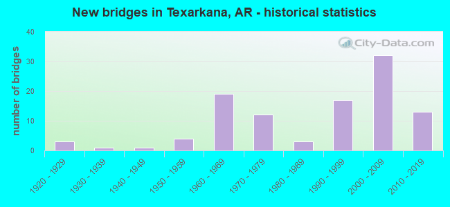
- New bridges - historical statistics
- 31920-1929
- 11930-1939
- 11940-1949
- 41950-1959
- 191960-1969
- 121970-1979
- 31980-1989
- 171990-1999
- 322000-2009
- 132010-2019

- Reconstructed bridges - Historical Statistics
- 31950-1959
- 01960-1969
- 01970-1979
- 41980-1989


- Bridge Condition - Deck
- 3.0%Very good
- 74.2%Good
- 22.7%Satisfactory

- Bridge Condition - Superstructure
- 39.4%Very good
- 36.4%Good
- 22.7%Satisfactory
- 1.5%Poor

- Bridge Condition - Substructure
- 39.4%Very good
- 39.4%Good
- 19.7%Satisfactory
- 1.5%Poor

- Bridge Condition - Channel
- 8.2%Very good
- 45.2%Good
- 42.5%Satisfactory
- 4.1%Fair

- Bridge Condition - Culverts
- 10.3%Very good
- 66.7%Good
- 20.5%Satisfactory
- 2.6%Fair
Find on map >> Show street view
Structure Number: B7092, Location: 3.27 MILES N OF I-30 (Lat: 33.516872, Lng: -94.010100), Route carried "under" structure: County highway 23, Structure Length: 0. m, Average Daily Traffic: 1,000 (year 2010), Truck Traffic: 1%, Features Intersected: SANDERSON LANE/C.R 23, Facility Carried by Structure: I 49 - 21-39.95
Minimum Vertical Clearance: 5.18m (16.99ft), Kilometerpoint: 0.370, Length of Maximum Span: 0.0m
Find on map >> Show street view
Structure Number: B7103, Location: 5.22 MI SOUTH OF US 71 (Lat: 33.479539, Lng: -93.986297), Route carried "under" structure: Interstate 30, Structure Length: 0. m, Average Daily Traffic: 14,500 (year 2013), Truck Traffic: 1%, Features Intersected: I-30-11-3.33, Facility Carried by Structure: I 49-1-36.64
Minimum Vertical Clearance: 5.27m (17.29ft), Kilometerpoint: 5.359, Length of Maximum Span: 0.0m
Find on map >> Show street view
Structure Number: B7103, Location: 5.22 MI SOUTH OF US 71 (Lat: 33.479539, Lng: -93.986297), Route carried "under" structure: Ramp Interstate 30, Structure Length: 0. m, Average Daily Traffic: 14,500 (year 2013), Truck Traffic: 1%, Features Intersected: I-30-11-3.33, Facility Carried by Structure: I 49-1-36.64
Minimum Vertical Clearance: 5.42m (17.78ft), Kilometerpoint: 5.359, Length of Maximum Span: 0.0m
Find on map >> Show street view
Structure Number: B7103, Location: 5.22 MI SOUTH OF US 71 (Lat: 33.479539, Lng: -93.986297), Route carried "under" structure: Interstate 30, Structure Length: 0. m, Average Daily Traffic: 14,500 (year 2013), Truck Traffic: 1%, Features Intersected: I-30-11-3.33, Facility Carried by Structure: I 49-1-36.64
Minimum Vertical Clearance: 5.39m (17.68ft), Kilometerpoint: 5.359, Length of Maximum Span: 0.0m
Find on map >> Show street view
Structure Number: B7105, Location: 0.6 MILES N. OF JCT.I-30 (Lat: 33.488219, Lng: -93.986681), Route carried "under" structure: State highway 296, Structure Length: 0. m, Average Daily Traffic: 1,400 (year 2014), Truck Traffic: 1%, Features Intersected: SH 296-SEC 0-3.30, Facility Carried by Structure: I 49-21-37.24
Minimum Vertical Clearance: 5.76m (18.90ft), Kilometerpoint: 5.311, Length of Maximum Span: 0.0m
Find on map >> Show street view
Structure Number: B7203, Location: TEX. ST. LINE & I30 (Lat: 33.469931, Lng: -94.043031), Route carried "under" structure: Interstate 30, Structure Length: 0. m, Average Daily Traffic: 12,000 (year 2012), Truck Traffic: 1%, Features Intersected: I-30 - SEC. 11 LM 0.001, Facility Carried by Structure: US71-SEC 3-LM 2.90
Minimum Vertical Clearance: 6.12m (20.08ft), Kilometerpoint: 0.002, Length of Maximum Span: 0.0m
Find on map >> Show street view
Structure Number: M2766, Location: 1.44 MI NE US 67 (Lat: 33.476372, Lng: -93.970986), Route carried "under" structure: State highway 296, Structure Length: 0. m, Average Daily Traffic: 660 (year 2014), Truck Traffic: 1%, Features Intersected: SH 296-SEC 1-1.44, Facility Carried by Structure: UNION PACIFIC RR
Minimum Vertical Clearance: 3.35m (10.99ft), Kilometerpoint: 2.317, Length of Maximum Span: 0.0m