Bridge Statistics for Thurmont, Maryland (MD)
Condition, Traffic, Stress, Structural Evaluation, Project Costs
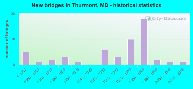
- New bridges - historical statistics
- 5Before 1900
- 11900-1909
- 21910-1919
- 31920-1929
- 11930-1939
- 61950-1959
- 31960-1969
- 101970-1979
- 181980-1989
- 21990-1999
- 12000-2009
- 12010-2019

- Reconstructed bridges - Historical Statistics
- 31970-1979
- 21980-1989
- 61990-1999
- 22000-2009
- 12010-2019


- Bridge Condition - Deck
- 6.3%Very good
- 34.4%Good
- 43.8%Satisfactory
- 12.5%Fair
- 3.1%Poor

- Bridge Condition - Superstructure
- 12.1%Very good
- 30.3%Good
- 39.4%Satisfactory
- 12.1%Fair
- 6.1%Poor

- Bridge Condition - Substructure
- 6.1%Very good
- 51.5%Good
- 21.2%Satisfactory
- 18.2%Fair
- 3.0%Poor

- Bridge Condition - Channel
- 12.5%Very good
- 40.0%Good
- 37.5%Satisfactory
- 10.0%Fair

- Bridge Condition - Culverts
- 7.7%Very good
- 46.2%Good
- 23.1%Satisfactory
- 23.1%Fair
Find on map >> Show street view
Structure Number: 300000F-NR0103, Location: CUNN. FALLS STATE PARK (Lat: 39.629639, Lng: -77.462922), Route carried "on" structure: State lands road , Year Built: 1980, Status: Open, Structure Length: 0.64m (2.10ft), Average Daily Traffic: 100 (year 2010), Truck Traffic: 5%, Average Future Daily Traffic: 120 (year 2032), Features Intersected: HUNTING CREEK, Facility Carried by Structure: NORTH BEACH ROAD
Minimum Vertical Clearance: 30+ m (98+ ft), Kilometerpoint: 0.000, Lanes on structure: 2, Owner: State Agenciy, Approaching Roadway Width: 6.7m (22.0ft), Skew: 4 degrees, Material/Design: Steel, Design/Construction: Culvert, Number Of Spans In Main Unit: 1, Length of Maximum Span: 4.3m (14.1ft)
Condition: Channel: Satisfactory, Culverts: Satisfactory, Operating Rating: 76.6 metric tons, Method Used To Determine Operating Rating: Field evaluation and documented engineering judgment, Inventory Rating: 76.6 metric tons, Method Used To Determine Inventory Rating: Field evaluation and documented engineering judgment, Structural Evaluation: Equal to present minimum criteria, Waterway Adequacy: Equal to present desirable criteria, Approach Roadway Alignment: Equal to present desirable criteria, Designated Inspection Frequency: Every 24 months, Inspection Date: August 2020
Find on map >> Show street view
Structure Number: 3220001P, Location: US-15N, WEST ON MC-77 TO (Lat: 39.635631, Lng: -77.450461), Route carried "on" structure: Federal lands road , Year Built: 1960, Status: Open, Structure Length: 0.62m (2.03ft), Average Daily Traffic: 50 (year 2013), Average Future Daily Traffic: 60 (year 2033), Features Intersected: BLUE BLAZES CREEK, Facility Carried by Structure: MAINTENANCE ROAD
Minimum Vertical Clearance: 30+ m (98+ ft), Kilometerpoint: 0.000, Lanes on structure: 1, Owner: National Park Service, Approaching Roadway Width: 3.8m (12.5ft), Skew: 4 degrees, Material/Design: Steel, Design/Construction: Culvert, Number Of Spans In Main Unit: 2, Length of Maximum Span: 3.0m (9.8ft), Curb-To-Curb Width: 3.8m (12.5ft), Out-to-Out Width: 11.6m (38.1ft)
Condition: Channel: Good, Culverts: Fair, Operating Rating: 26.3 metric tons, Method Used To Determine Operating Rating: Load Factor (LF), Inventory Rating: 15.4 metric tons, Method Used To Determine Inventory Rating: Load Factor (LF), Structural Evaluation: Meets minimum limits, Deck Geometry: Meets minimum limits, Waterway Adequacy: Equal to present minimum criteria, Approach Roadway Alignment: Equal to present desirable criteria, Designated Inspection Frequency: Every 24 months, Inspection Date: December 2019
Find on map >> Show street view
Structure Number: 3220002P, Location: US-15N, WEST ON MC-77 TO (Lat: 39.634175, Lng: -77.450678), Route carried "on" structure: Federal lands road , Year Built: 2019, Status: Open, Structure Length: 1.04m (3.41ft), Average Daily Traffic: 20 (year 2013), Average Future Daily Traffic: 24 (year 2033), Design Load: Greater than HL93, Features Intersected: BLUE BLAZES CREEK, Facility Carried by Structure: PARKING LOT ROAD
Minimum Vertical Clearance: 30+ m (98+ ft), Kilometerpoint: 0.000, Lanes on structure: 1, Owner: National Park Service, Approaching Roadway Width: 7.4m (24.3ft), Skew: 2 degrees, Material/Design: Prestressed concrete continuous, Design/Construction: Box Beam or Girders - Single/Spread, Number Of Spans In Main Unit: 1, Length of Maximum Span: 9.1m (29.9ft), Curb or Sidewalk Widths: Left: 1.5m (4.9ft), Right: 0.0m, Curb-To-Curb Width: 5.3m (17.4ft), Out-to-Out Width: 7.4m (24.3ft)
Condition: Deck: Very good, Superstructure: Very good, Substructure: Very good, Channel: Good, Operating Rating: 65.3 metric tons, Method Used To Determine Operating Rating: Load and Resistance Factor (LRFR), Inventory Rating: 50.8 metric tons, Method Used To Determine Inventory Rating: Load and Resistance Factor (LRFR), Structural Evaluation: Equal to present desirable criteria, Deck Geometry: High priority of corrective action, Waterway Adequacy: Equal to present minimum criteria, Approach Roadway Alignment: Equal to present desirable criteria, Designated Inspection Frequency: Every 24 months, Inspection Date: December 2019, Deck Structure Type: Concrete Cast-file-Place, Wearing Surface/Protective System: Wearing Surface: Monolithic Concrete, Deck Protection: Epoxy Coated Reinforcing
Find on map >> Show street view
Structure Number: 10000010010901, Location: 0.03 M E OF MOUNTAIN ROAD (Lat: 39.624558, Lng: -77.418092), Route carried "under" structure: State highway 77, Year Built: 1957, Structure Length: 0. m, Average Daily Traffic: 8,551 (year 2009), Features Intersected: MD 77, HUNTING CREEK, Facility Carried by Structure: US 15 NBR
Minimum Vertical Clearance: 4.88m (16.01ft), Kilometerpoint: 11.392, Lanes on structure: 2, Lanes under structure: 2, Material/Design: Steel, Design/Construction: Stringer/Multi-beam, Length of Maximum Span: 18.9m (62.0ft)
Find on map >> Show street view
Structure Number: 10000010015401, Location: 0.8 MILE SOUTH OF MD 77 (Lat: 39.634697, Lng: -77.410917), Route carried "under" structure: State highway 550, Year Built: 1972, Structure Length: 0. m, Average Daily Traffic: 7,221 (year 2009), Features Intersected: MD 550, Facility Carried by Structure: US 15 NBR
Minimum Vertical Clearance: 5.18m (16.99ft), Kilometerpoint: 23.668, Lanes on structure: 2, Lanes under structure: 4, Material/Design: Steel, Design/Construction: Stringer/Multi-beam, Length of Maximum Span: 29.6m (97.1ft)
Find on map >> Show street view
Structure Number: 10000010016901, Location: 0.37 MI N OF MD 15D (Lat: 39.635161, Lng: -77.410419), Route carried "under" structure: State highway 550, Year Built: 1982, Structure Length: 0. m, Average Daily Traffic: 7,221 (year 2009), Features Intersected: MD 550, Facility Carried by Structure: US 15 SBR
Minimum Vertical Clearance: 4.88m (16.01ft), Kilometerpoint: 23.556, Lanes on structure: 2, Lanes under structure: 4, Material/Design: Steel, Design/Construction: Stringer/Multi-beam, Length of Maximum Span: 29.6m (97.1ft)
Find on map >> Show street view
Structure Number: 10000010017901, Location: 0.03 M E OF MOUNTAIN ROAD (Lat: 39.625317, Lng: -77.418464), Route carried "under" structure: State highway 77, Year Built: 1985, Structure Length: 0. m, Average Daily Traffic: 8,551 (year 2009), Features Intersected: MD 77, HUNTING CREEK, Facility Carried by Structure: US 15 NBR
Minimum Vertical Clearance: 4.88m (16.01ft), Kilometerpoint: 11.392, Lanes on structure: 2, Lanes under structure: 2, Material/Design: Steel, Design/Construction: Girder and Floorbeam System, Length of Maximum Span: 32.3m (106.0ft)
Find on map >> Show street view
Structure Number: 100000100181011, Location: 0.76 MI S OF MD 77 (Lat: 39.614481, Lng: -77.420072), Route carried "under" structure: State highway 15C, Year Built: 1985, Structure Length: 0. m, Average Daily Traffic: 999 (year 2006), Features Intersected: MD 15C, Facility Carried by Structure: US 15 NBR
Minimum Vertical Clearance: 5.49m (18.01ft), Kilometerpoint: 0.097, Lanes on structure: 2, Lanes under structure: 2, Material/Design: Steel, Design/Construction: Girder and Floorbeam System, Length of Maximum Span: 33.2m (108.9ft)
Find on map >> Show street view
Structure Number: 100000100181012, Location: 0.76 MI S OF MD 77 (Lat: 39.614831, Lng: -77.420119), Route carried "under" structure: Ramp State highway 15C, Year Built: 1985, Structure Length: 0. m, Average Daily Traffic: 999 (year 2006), Features Intersected: MD 15C, Facility Carried by Structure: US 15 SBR
Minimum Vertical Clearance: 5.49m (18.01ft), Kilometerpoint: 0.064, Lanes on structure: 2, Lanes under structure: 2, Material/Design: Steel, Design/Construction: Girder and Floorbeam System, Length of Maximum Span: 33.2m (108.9ft)
Find on map >> Show street view
Structure Number: 10000010018213, Location: 0.913 M N OF MD 806A (Lat: 39.584239, Lng: -77.434989), Route carried "under" structure: US 15, Year Built: 1983, Structure Length: 0. m, Average Daily Traffic: 30,800 (year 2009), Features Intersected: US 15, Facility Carried by Structure: PEDESTRIAN
Minimum Vertical Clearance: 30+ m (98+ ft), Kilometerpoint: 41.124, Lanes under structure: 4, Material/Design: Steel, Design/Construction: Stringer/Multi-beam, Length of Maximum Span: 36.3m (119.1ft)