Bridge Statistics for Toccoa, Georgia (GA)
Condition, Traffic, Stress, Structural Evaluation, Project Costs
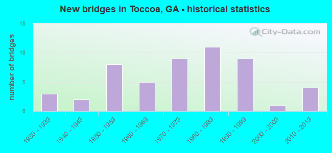
- New bridges - historical statistics
- 31930-1939
- 21940-1949
- 81950-1959
- 51960-1969
- 91970-1979
- 111980-1989
- 91990-1999
- 12000-2009
- 42010-2019

- Reconstructed bridges - Historical Statistics
- 11940-1949
- 11950-1959
- 01960-1969
- 11970-1979


- Bridge Condition - Deck
- 70.0%Good
- 25.0%Satisfactory
- 5.0%Fair

- Bridge Condition - Superstructure
- 25.0%Very good
- 55.0%Good
- 5.0%Satisfactory
- 10.0%Fair
- 5.0%Poor

- Bridge Condition - Substructure
- 15.0%Very good
- 55.0%Good
- 20.0%Satisfactory
- 10.0%Poor

- Bridge Condition - Channel
- 26.7%Very good
- 22.2%Good
- 20.0%Satisfactory
- 28.9%Fair
- 2.2%Poor

- Bridge Condition - Culverts
- 96.9%Good
- 3.1%Satisfactory
Find on map >> Show street view
Structure Number: 2575053, Location: AT TOCCOA RESERVOIR (Lat: 34.613558, Lng: -83.357200), Route carried "on" structure: County highway 171, Year Built: 1994, Status: Open, Structure Length: 0.64m (2.10ft), Average Daily Traffic: 960 (year 2011), Truck Traffic: 1%, Average Future Daily Traffic: 1,440 (year 2031), Design Load: HS 20+Mod, Features Intersected: CEDAR CREEK, Facility Carried by Structure: BLACK MTN ROAD
Minimum Vertical Clearance: 30+ m (98+ ft), Kilometerpoint: 0.000, Lanes on structure: 2, Base Highway Network: Yes, Owner: County Highway Agency, Approaching Roadway Width: 5.5m (18.0ft), Material/Design: Concrete, Design/Construction: Culvert, Number Of Spans In Main Unit: 2, Length of Maximum Span: 3.0m (9.8ft)
Condition: Channel: Good, Culverts: Good, Operating Rating: 55.3 metric tons, Method Used To Determine Operating Rating: Field evaluation and documented engineering judgment, Inventory Rating: 32.6 metric tons, Method Used To Determine Inventory Rating: Field evaluation and documented engineering judgment, Structural Evaluation: Better than present minimum criteria, Waterway Adequacy: Equal to present desirable criteria, Approach Roadway Alignment: Equal to present desirable criteria, Designated Inspection Frequency: Every 24 months, Inspection Date: Febuary 2021, Bridge Improvement Cost: $82,000, Roadway Improvement Cost: $8,000, Total Project Cost: $123,000
Find on map >> Show street view
Structure Number: 2575054, Location: 3 MI SW TOCCOA (Lat: 34.606219, Lng: -83.238450), Route carried "on" structure: County highway 146, Year Built: 1996, Status: Open, Structure Length: 3.05m (10.01ft), Average Daily Traffic: 600 (year 2011), Truck Traffic: 1%, Average Future Daily Traffic: 900 (year 2031), Design Load: HS 20+Mod, Features Intersected: WALTON CREEK, Facility Carried by Structure: RIVERDALE ROAD
Minimum Vertical Clearance: 30+ m (98+ ft), Kilometerpoint: 0.000, Lanes on structure: 2, Base Highway Network: Yes, Owner: County Highway Agency, Approaching Roadway Width: 6.7m (22.0ft), Material/Design: Prestressed concrete, Design/Construction: Stringer/Multi-beam, Number Of Spans In Main Unit: 3, Length of Maximum Span: 12.2m (40.0ft), Curb-To-Curb Width: 9.8m (32.2ft), Out-to-Out Width: 10.7m (35.1ft)
Condition: Deck: Good, Superstructure: Very good, Substructure: Good, Channel: Very good, Operating Rating: 53.5 metric tons, Method Used To Determine Operating Rating: Load Factor (LF), Inventory Rating: 31.7 metric tons, Method Used To Determine Inventory Rating: Load Factor (LF), Structural Evaluation: Better than present minimum criteria, Deck Geometry: Equal to present minimum criteria, Waterway Adequacy: Superior to present desirable criteria, Approach Roadway Alignment: Equal to present desirable criteria, Designated Inspection Frequency: Every 24 months, Underwater Inspection Frequency: Every 60 months, Inspection Date: Febuary 2021, Underwater Inspection Date: October 2019, Bridge Improvement Cost: $391,000, Roadway Improvement Cost: $39,000, Total Project Cost: $586,000, Deck Structure Type: Concrete Cast-file-Place
Find on map >> Show street view
Structure Number: 2575056, Location: 4.3 MI SE. OF TOCCOA (Lat: 34.532269, Lng: -83.273839), Route carried "on" structure: County highway 642, Year Built: 1998, Status: Open, Structure Length: 1.04m (3.41ft), Average Daily Traffic: 600 (year 2011), Truck Traffic: 1%, Average Future Daily Traffic: 900 (year 2031), Design Load: HS 20+Mod, Features Intersected: EASTANOLLEE CREEK, Facility Carried by Structure: CLARY CONNECTOR
Minimum Vertical Clearance: 30+ m (98+ ft), Kilometerpoint: 1.609, Lanes on structure: 2, Base Highway Network: Yes, Owner: County Highway Agency, Approaching Roadway Width: 6.4m (21.0ft), Skew: 3 degrees, Material/Design: Concrete, Design/Construction: Culvert, Number Of Spans In Main Unit: 3, Length of Maximum Span: 3.0m (9.8ft)
Condition: Channel: Fair, Culverts: Good, Operating Rating: 55.3 metric tons, Method Used To Determine Operating Rating: Field evaluation and documented engineering judgment, Inventory Rating: 32.6 metric tons, Method Used To Determine Inventory Rating: Field evaluation and documented engineering judgment, Structural Evaluation: Better than present minimum criteria, Waterway Adequacy: Equal to present desirable criteria, Approach Roadway Alignment: Better than present minimum criteria, Designated Inspection Frequency: Every 24 months, Inspection Date: Febuary 2021, Bridge Improvement Cost: $133,000, Roadway Improvement Cost: $13,000, Total Project Cost: $199,000
Find on map >> Show street view
Structure Number: 2575059, Location: 5 MI EAST OF TOCCOA (Lat: 34.595569, Lng: -83.241228), Route carried "on" structure: County highway 144, Year Built: 2007, Status: Open, Structure Length: 0.98m (3.22ft), Average Daily Traffic: 110 (year 2011), Truck Traffic: 1%, Average Future Daily Traffic: 165 (year 2031), Design Load: HS 20+Mod, Features Intersected: WARDS CREEK, Facility Carried by Structure: WARDS CREEK ROAD
Minimum Vertical Clearance: 30+ m (98+ ft), Kilometerpoint: 0.000, Lanes on structure: 2, Base Highway Network: Yes, Owner: County Highway Agency, Approaching Roadway Width: 5.2m (17.1ft), Material/Design: Concrete, Design/Construction: Culvert, Number Of Spans In Main Unit: 3, Length of Maximum Span: 3.0m (9.8ft)
Condition: Channel: Very good, Culverts: Good, Operating Rating: 89.8 metric tons, Method Used To Determine Operating Rating: Field evaluation and documented engineering judgment, Inventory Rating: 89.8 metric tons, Method Used To Determine Inventory Rating: Field evaluation and documented engineering judgment, Structural Evaluation: Better than present minimum criteria, Waterway Adequacy: Superior to present desirable criteria, Approach Roadway Alignment: Better than present minimum criteria, Designated Inspection Frequency: Every 24 months, Inspection Date: Febuary 2021, Bridge Improvement Cost: $125,000, Roadway Improvement Cost: $13,000, Total Project Cost: $188,000
Find on map >> Show street view
Structure Number: 257506, Location: 3.5 MI NE OF TOCCOA (Lat: 34.619458, Lng: -83.297689), Route carried "on" structure: State highway 184, Year Built: 2017, Status: Open, Structure Length: 5.03m (16.50ft), Average Daily Traffic: 1,000 (year 2017), Truck Traffic: 4%, Average Future Daily Traffic: 1,400 (year 2037), Design Load: HL 93, Features Intersected: TOCCOA CREEK
Minimum Vertical Clearance: 30+ m (98+ ft), Kilometerpoint: 24.140, Lanes on structure: 2, Base Highway Network: Yes, Owner: State Highway Agency, Approaching Roadway Width: 7.3m (24.0ft), Material/Design: Prestressed concrete, Design/Construction: Stringer/Multi-beam, Number Of Spans In Main Unit: 3, Length of Maximum Span: 25.9m (85.0ft), Curb-To-Curb Width: 11.0m (36.1ft), Out-to-Out Width: 11.9m (39.0ft)
Condition: Deck: Good, Superstructure: Very good, Substructure: Good, Channel: Very good, Operating Rating: 74.3 metric tons, Method Used To Determine Operating Rating: Load Factor (LF), Inventory Rating: 42.6 metric tons, Method Used To Determine Inventory Rating: Load Factor (LF), Structural Evaluation: Better than present minimum criteria, Deck Geometry: Better than present minimum criteria, Waterway Adequacy: Equal to present desirable criteria, Approach Roadway Alignment: Better than present minimum criteria, Length Of Structure Improvement: 6.04m (19.82ft), Designated Inspection Frequency: Every 24 months, Inspection Date: Febuary 2021, Bridge Improvement Cost: $14,652,000, Roadway Improvement Cost: $1,465,000, Total Project Cost: $21,978,000 ( Estimate for 2016), Deck Structure Type: Concrete Cast-file-Place
Find on map >> Show street view
Structure Number: 2575061, Location: 5.2 MI SE OF TOCCOA (Lat: 34.534958, Lng: -83.259758), Route carried "on" structure: State highway 17, Year Built: 2015, Status: Open, Structure Length: 7.10m (23.29ft), Average Daily Traffic: 11,930 (year 2011), Truck Traffic: 8%, Average Future Daily Traffic: 42,490 (year 2035), Design Load: HS 20+Mod, Features Intersected: OGGS BRANCH
Minimum Vertical Clearance: 30+ m (98+ ft), Kilometerpoint: 9.656, Lanes on structure: 4, Base Highway Network: Yes, Owner: State Highway Agency, Approaching Roadway Width: 10.5m (34.4ft), Skew: 14 degrees, Material/Design: Prestressed concrete, Design/Construction: Stringer/Multi-beam, Number Of Spans In Main Unit: 3, Length of Maximum Span: 39.3m (128.9ft), Curb-To-Curb Width: 25.6m (84.0ft), Out-to-Out Width: 26.6m (87.3ft)
Condition: Deck: Good, Superstructure: Very good, Substructure: Very good, Channel: Fair, Operating Rating: 61.6 metric tons, Method Used To Determine Operating Rating: Load Factor (LF), Inventory Rating: 30.8 metric tons, Method Used To Determine Inventory Rating: Load Factor (LF), Structural Evaluation: Better than present minimum criteria, Deck Geometry: Superior to present desirable criteria, Waterway Adequacy: Superior to present desirable criteria, Approach Roadway Alignment: Equal to present desirable criteria, Length Of Structure Improvement: 8.53m (27.99ft), Designated Inspection Frequency: Every 24 months, Inspection Date: Febuary 2021, Bridge Improvement Cost: $20,720,000, Roadway Improvement Cost: $2,072,000, Total Project Cost: $31,080,000 ( Estimate for 2016), Deck Structure Type: Concrete Cast-file-Place
Find on map >> Show street view
Structure Number: 2575062, Location: 3.8 MI NW OF AVALON (Lat: 34.530569, Lng: -83.252608), Route carried "on" structure: State highway 17, Year Built: 2015, Status: Open, Structure Length: 3.87m (12.70ft), Average Daily Traffic: 11,930 (year 2011), Truck Traffic: 8%, Average Future Daily Traffic: 37,600 (year 2030), Design Load: HS 20+Mod, Features Intersected: EASTANOLLEE CREEK
Minimum Vertical Clearance: 30+ m (98+ ft), Kilometerpoint: 9.656, Lanes on structure: 6, Base Highway Network: Yes, Owner: State Highway Agency, Approaching Roadway Width: 14.3m (46.9ft), Skew: 11 degrees, Material/Design: Prestressed concrete, Design/Construction: Stringer/Multi-beam, Number Of Spans In Main Unit: 1, Length of Maximum Span: 38.7m (127.0ft), Curb-To-Curb Width: 30.2m (99.1ft), Out-to-Out Width: 31.1m (102.0ft)
Condition: Deck: Good, Superstructure: Very good, Substructure: Very good, Channel: Good, Operating Rating: 94.3 metric tons, Method Used To Determine Operating Rating: Load Factor (LF), Inventory Rating: 39.0 metric tons, Method Used To Determine Inventory Rating: Load Factor (LF), Structural Evaluation: Equal to present desirable criteria, Deck Geometry: Superior to present desirable criteria, Waterway Adequacy: Equal to present desirable criteria, Approach Roadway Alignment: Better than present minimum criteria, Length Of Structure Improvement: 4.63m (15.19ft), Designated Inspection Frequency: Every 24 months, Inspection Date: Febuary 2021, Bridge Improvement Cost: $11,248,000, Roadway Improvement Cost: $1,125,000, Total Project Cost: $16,872,000 ( Estimate for 2016), Deck Structure Type: Concrete Cast-file-Place
Find on map >> Show street view
Structure Number: 2575063, Location: 3.2 MI SW OF TOCCOA (Lat: 34.532519, Lng: -83.342708), Route carried "on" structure: County highway 292, Year Built: 2018, Status: Open, Structure Length: 3.35m (10.99ft), Average Daily Traffic: 600 (year 2011), Truck Traffic: 1%, Average Future Daily Traffic: 900 (year 2031), Design Load: HS 20+Mod, Features Intersected: NORTH FORK BROAD RIVER, Facility Carried by Structure: CURRAHEE LANE
Minimum Vertical Clearance: 30+ m (98+ ft), Kilometerpoint: 1.609, Lanes on structure: 2, Base Highway Network: Yes, Owner: County Highway Agency, Approaching Roadway Width: 9.1m (29.9ft), Skew: 3 degrees, Material/Design: Prestressed concrete, Design/Construction: Stringer/Multi-beam, Number Of Spans In Main Unit: 1, Length of Maximum Span: 33.5m (109.9ft), Curb-To-Curb Width: 9.1m (29.9ft), Out-to-Out Width: 10.1m (33.1ft)
Condition: Deck: Good, Superstructure: Very good, Substructure: Very good, Channel: Very good, Operating Rating: 92.5 metric tons, Method Used To Determine Operating Rating: Load Factor (LF), Inventory Rating: 46.2 metric tons, Method Used To Determine Inventory Rating: Load Factor (LF), Structural Evaluation: Equal to present desirable criteria, Deck Geometry: Equal to present minimum criteria, Waterway Adequacy: Better than present minimum criteria, Approach Roadway Alignment: Better than present minimum criteria, Length Of Structure Improvement: 4.02m (13.19ft), Designated Inspection Frequency: Every 24 months, Inspection Date: Febuary 2021, Bridge Improvement Cost: $9,768,000, Roadway Improvement Cost: $977,000, Total Project Cost: $14,652,000 ( Estimate for 2018), Deck Structure Type: Concrete Cast-file-Place
Find on map >> Show street view
Structure Number: 2579001, Location: 10 MI W WESTMINSTER (Lat: 34.647706, Lng: -83.279536), Route carried "on" structure: State highway 160, Year Built: 1967, Status: Open, Structure Length: 11.09m (36.38ft), Average Daily Traffic: 300 (year 2020), Truck Traffic: 4%, Average Future Daily Traffic: 438 (year 2040), Design Load: HS 15, Features Intersected: TUGALOO RIVER
Minimum Vertical Clearance: 30+ m (98+ ft), Kilometerpoint: 11.209, Lanes on structure: 2, Owner: State Highway Agency, Approaching Roadway Width: 7.3m (24.0ft), Material/Design: Prestressed concrete, Design/Construction: Stringer/Multi-beam, Number Of Spans In Main Unit: 7, Length of Maximum Span: 15.8m (51.8ft), Curb-To-Curb Width: 8.0m (26.2ft), Out-to-Out Width: 9.2m (30.2ft)
Condition: Deck: Good, Superstructure: Good, Substructure: Good, Channel: Satisfactory, Operating Rating: 48.6 metric tons, Method Used To Determine Operating Rating: Load and Resistance Factor Rating (LRFR) rating reported by rating factor(RF) method using HL-93 loadings, Inventory Rating: 29.5 metric tons, Method Used To Determine Inventory Rating: Load and Resistance Factor Rating (LRFR) rating reported by rating factor(RF) method using HL-93 loadings, Structural Evaluation: Better than present minimum criteria, Deck Geometry: Somewhat better than minimum adequacy, Waterway Adequacy: Equal to present desirable criteria, Approach Roadway Alignment: Equal to present desirable criteria, Length Of Structure Improvement: 11.09m (36.38ft), Designated Inspection Frequency: Every 24 months, Underwater Inspection Frequency: Every 60 months, Inspection Date: April 2021, Underwater Inspection Date: November 2020, Deck Structure Type: Concrete Cast-file-Place, Wearing Surface/Protective System: Wearing Surface: Monolithic Concrete
Find on map >> Show street view
Structure Number: 2570017, Location: INSIDE TOCCOA CITY LIMITS (Lat: 34.578239, Lng: -83.333089), Route carried "under" structure: State highway 184, Structure Length: 0. m, Average Daily Traffic: 7,600 (year 2011), Truck Traffic: 1%, Features Intersected: SR 184, Facility Carried by Structure: NORFOLK SOUTHERN
Minimum Vertical Clearance: 4.34m (14.24ft), Kilometerpoint: 16.093, Length of Maximum Span: 0.0m
Find on map >> Show street view
Structure Number: 2570018, Location: 3 MI NE OF TOCCOA (Lat: 34.595700, Lng: -83.283528), Route carried "under" structure: City street 1268, Structure Length: 0. m, Average Daily Traffic: 1,150 (year 2011), Truck Traffic: 1%, Features Intersected: FAS 1268, Facility Carried by Structure: NORFOLK SOUTHERN R
Minimum Vertical Clearance: 3.75m (12.30ft), Kilometerpoint: 1.609, Length of Maximum Span: 0.0m
Find on map >> Show street view
Structure Number: 2570019, Location: 3 MI NE OF TOCCOA (Lat: 34.595500, Lng: -83.283100), Route carried "under" structure: City street 1268, Structure Length: 0. m, Average Daily Traffic: 1,150 (year 2011), Truck Traffic: 1%, Features Intersected: FAS 1268, Facility Carried by Structure: NORFOLK SOUTHERN R
Minimum Vertical Clearance: 3.63m (11.91ft), Kilometerpoint: 1.609, Length of Maximum Span: 0.0m