Bridge Statistics for Trinidad, Colorado (CO)
Condition, Traffic, Stress, Structural Evaluation, Project Costs
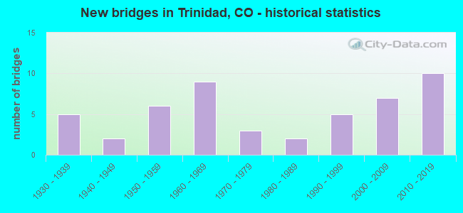
- New bridges - historical statistics
- 51930-1939
- 21940-1949
- 61950-1959
- 91960-1969
- 31970-1979
- 21980-1989
- 51990-1999
- 72000-2009
- 102010-2019
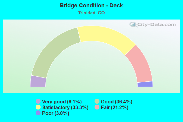
- Bridge Condition - Deck
- 6.1%Very good
- 36.4%Good
- 33.3%Satisfactory
- 21.2%Fair
- 3.0%Poor
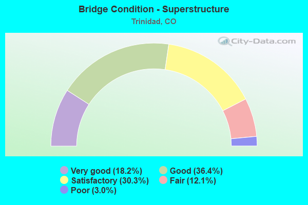
- Bridge Condition - Superstructure
- 18.2%Very good
- 36.4%Good
- 30.3%Satisfactory
- 12.1%Fair
- 3.0%Poor
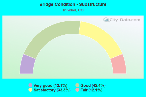
- Bridge Condition - Substructure
- 12.1%Very good
- 42.4%Good
- 33.3%Satisfactory
- 12.1%Fair
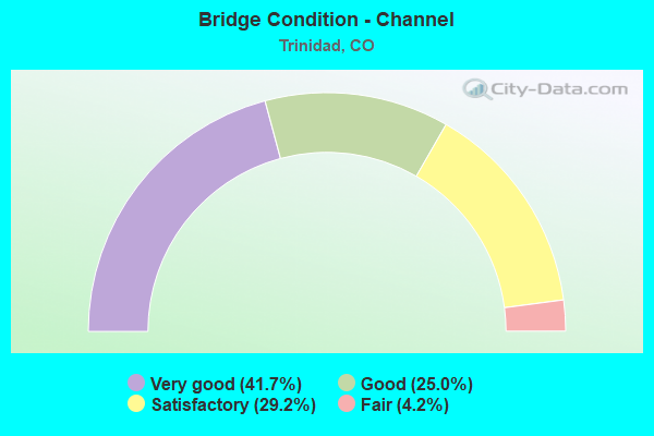
- Bridge Condition - Channel
- 41.7%Very good
- 25.0%Good
- 29.2%Satisfactory
- 4.2%Fair
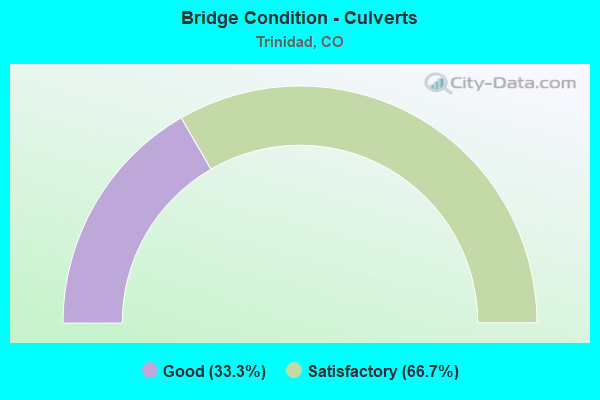
- Bridge Condition - Culverts
- 33.3%Good
- 66.7%Satisfactory
Find on map >> Show street view
Structure Number: P-18-BI, Location: In TRINIDAD (Lat: 37.165297, Lng: -104.511994), Route carried "under" structure: City street , Year Built: 2009, Structure Length: 0. m, Features Intersected: MAIN STREET, Facility Carried by Structure: I 25 ML NBND
Minimum Vertical Clearance: 5.54m (18.18ft), Kilometerpoint: 0.000, Lanes on structure: 2, Lanes under structure: 2, Material/Design: Prestressed concrete continuous, Design/Construction: Box Beam or Girders - Multiple, Length of Maximum Span: 36.0m (118.1ft)
Find on map >> Show street view
Structure Number: P-18-BJ, Location: IN TRINIDAD (Lat: 37.165311, Lng: -104.512233), Route carried "under" structure: City street , Year Built: 2012, Structure Length: 0. m, Features Intersected: MAIN STREET, Facility Carried by Structure: I 25 ML SBND
Minimum Vertical Clearance: 5.54m (18.18ft), Kilometerpoint: 0.000, Lanes on structure: 2, Lanes under structure: 2, Material/Design: Prestressed concrete, Design/Construction: Box Beam or Girders - Single/Spread, Length of Maximum Span: 37.2m (122.0ft)
Find on map >> Show street view
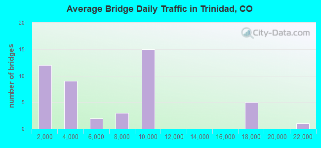
Structure Number: P-18-BS, Location: 1.8 MI S. OF TRINIDAD (Lat: 37.134292, Lng: -104.521681), Route carried "under" structure: Interstate 25A, Year Built: 1968, Structure Length: 0. m, Average Daily Traffic: 3,300 (year 2014), Truck Traffic: 16%, Features Intersected: I 25 ML, Facility Carried by Structure: COUNTY ROAD 18.9
Minimum Vertical Clearance: 6.00m (19.69ft), Kilometerpoint: 0.047, Lanes on structure: 2, Lanes under structure: 4, Material/Design: Concrete continuous, Design/Construction: Tee Beam, Length of Maximum Span: 16.5m (54.1ft)
Find on map >> Show street view
Structure Number: P-18-BY, Location: IN TRINIDAD (Lat: 37.169308, Lng: -104.511014), Route carried "under" structure: US 12A, Year Built: 2009, Structure Length: 0. m, Average Daily Traffic: 8,100 (year 2011), Truck Traffic: 2%, Features Intersected: SH 12,RR,CTY STS. DITCH, Facility Carried by Structure: I 25 ML NBND
Minimum Vertical Clearance: 7.34m (24.08ft), Kilometerpoint: 113.251, Lanes on structure: 2, Lanes under structure: 10, Material/Design: Prestressed concrete continuous, Design/Construction: Box Beam or Girders - Single/Spread, Length of Maximum Span: 76.8m (252.0ft)
Find on map >> Show street view
Structure Number: P-18-CE, Location: IN TRINIDAD (Lat: 37.169342, Lng: -104.511283), Route carried "under" structure: US 12A, Year Built: 2010, Structure Length: 0. m, Average Daily Traffic: 8,100 (year 2011), Truck Traffic: 2%, Features Intersected: SH12,RR,CITY ST,DITCH, Facility Carried by Structure: I 25 ML SBND
Minimum Vertical Clearance: 4.75m (15.58ft), Kilometerpoint: 113.249, Lanes on structure: 2, Lanes under structure: 11, Material/Design: Prestressed concrete continuous, Design/Construction: Box Beam or Girders - Single/Spread, Length of Maximum Span: 69.5m (228.0ft)
Find on map >> Show street view
Structure Number: P-18-CM, Location: I25 OVER CITY STREET (Lat: 37.171339, Lng: -104.509906), Route carried "under" structure: City street , Year Built: 2010, Structure Length: 0. m, Average Daily Traffic: 20,000 (year 0000), Features Intersected: CITY STREET, Facility Carried by Structure: I25 RAMP
Minimum Vertical Clearance: 5.26m (17.26ft), Kilometerpoint: 0.000, Lanes on structure: 1, Lanes under structure: 2, Material/Design: Prestressed concrete continuous, Design/Construction: Box Beam or Girders - Single/Spread, Length of Maximum Span: 38.4m (126.0ft)
Find on map >> Show street view
Structure Number: P-19-BA, Location: 2.9 MI NO OF JCT SH 239 (Lat: 37.226356, Lng: -104.492736), Route carried "under" structure: Interstate 25A, Year Built: 1969, Structure Length: 0. m, Average Daily Traffic: 200 (year 2014), Truck Traffic: 16%, Features Intersected: I 25 ML, Facility Carried by Structure: COUNTY ROAD 32.4
Minimum Vertical Clearance: 5.33m (17.49ft), Kilometerpoint: 0.235, Lanes on structure: 2, Lanes under structure: 4, Material/Design: Steel continuous, Design/Construction: Stringer/Multi-beam, Length of Maximum Span: 38.4m (126.0ft)