Bridge Statistics for Universal City, Texas (TX)
Condition, Traffic, Stress, Structural Evaluation, Project Costs
- National Bridge Inventory (NBI) Statistics
- 17Number of bridges
- 266ft / 81.0mTotal length
- $38,000Total costs
- 428,433Total average daily traffic
- 22,762Total average daily truck traffic
- National Bridge Inventory (NBI) Registered Bridges for Universal City
- No street view available for this location
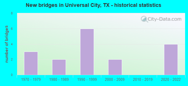
- New bridges - historical statistics
- 31970-1979
- 21980-1989
- 61990-1999
- 22000-2009
- 42020-2022


- Bridge Condition - Deck
- 33.3%Very good
- 33.3%Good
- 33.3%Satisfactory

- Bridge Condition - Superstructure
- 50.0%Very good
- 50.0%Good

- Bridge Condition - Substructure
- 50.0%Very good
- 50.0%Good

- Bridge Condition - Channel
- 33.3%Good
- 66.7%Satisfactory

- Bridge Condition - Culverts
- 60.0%Good
- 40.0%Satisfactory
Find on map >> Show street view
Structure Number: 150150002509227, Location: 10.7 MI NE OF IH 410 (Lat: 29.550444, Lng: -98.273706), Route carried "on" structure: State highway 78, Year Built: 2002, Status: Open, Structure Length: 16.76m (54.99ft), Average Daily Traffic: 25,404 (year 2020), Truck Traffic: 4%, Average Future Daily Traffic: 33,660 (year 2030), Design Load: HS 20, Features Intersected: CIBOLO CREEK & AZTEC WAY
Minimum Vertical Clearance: 30+ m (98+ ft), Kilometerpoint: 33.341, Lanes on structure: 5, Lanes under structure: 2, Owner: State Highway Agency, Approaching Roadway Width: 18.9m (62.0ft), Skew: 9 degrees, Material/Design: Prestressed concrete, Design/Construction: Box Beam or Girders - Multiple, Number Of Spans In Main Unit: 9, Length of Maximum Span: 19.2m (63.0ft), Curb or Sidewalk Widths: Left: 0.0m, Right: 1.7m (5.6ft), Curb-To-Curb Width: 18.9m (62.0ft), Out-to-Out Width: 21.3m (69.9ft)
Condition: Deck: Good, Superstructure: Good, Substructure: Good, Channel: Satisfactory, Operating Rating: 54.4 metric tons, Method Used To Determine Operating Rating: Assigned rating based on Load Factor Design (LFD) reported in metric tons, Inventory Rating: 32.7 metric tons, Method Used To Determine Inventory Rating: Assigned rating based on Load Factor Design (LFD) reported in metric tons, Structural Evaluation: Better than present minimum criteria, Deck Geometry: Meets minimum limits, Underclear: Meets minimum limits, Waterway Adequacy: Superior to present desirable criteria, Approach Roadway Alignment: Equal to present desirable criteria, Designated Inspection Frequency: Every 24 months, Inspection Date: June 2020, Deck Structure Type: Concrete Cast-file-Place
Find on map >> Show street view
Structure Number: 150150046501176, Location: 0.70 Mi S of LP 1604 (Lat: 29.562036, Lng: -98.341858), Route carried "on" structure: State highway 218, Year Built: 1988, Status: Open, Structure Length: 0.88m (2.89ft), Average Daily Traffic: 20,729 (year 2020), Truck Traffic: 3%, Average Future Daily Traffic: 19,090 (year 2034), Design Load: HS 20, Features Intersected: Draw
Minimum Vertical Clearance: 30+ m (98+ ft), Kilometerpoint: 0.546, Lanes on structure: 3, Owner: State Highway Agency, Approaching Roadway Width: 13.1m (43.0ft), Skew: 2 degrees, Material/Design: Concrete, Design/Construction: Culvert, Number Of Spans In Main Unit: 3, Length of Maximum Span: 2.4m (7.9ft)
Condition: Channel: Good, Culverts: Good, Operating Rating: 39.9 metric tons, Method Used To Determine Operating Rating: Load Factor (LF), Inventory Rating: 23.6 metric tons, Method Used To Determine Inventory Rating: Load Factor (LF), Structural Evaluation: Somewhat better than minimum adequacy, Waterway Adequacy: Equal to present minimum criteria, Approach Roadway Alignment: Equal to present desirable criteria, Designated Inspection Frequency: Every 48 months, Inspection Date: August 2018
Find on map >> Show street view
Structure Number: 150150046501195, Location: 0.4 Mile S of IH 35 (Lat: 29.560033, Lng: -98.326675), Route carried "on" structure: State highway 1604, Year Built: 2020, Status: Open, Structure Length: 13.20m (43.31ft), Average Daily Traffic: 36,180 (year 2013), Truck Traffic: 7%, Average Future Daily Traffic: 50,650 (year 2033), Design Load: HL 93, Features Intersected: SH 218 (Pat Booker Rd)
Minimum Vertical Clearance: 30+ m (98+ ft), Kilometerpoint: 61.448, Lanes on structure: 3, Lanes under structure: 8, Owner: State Highway Agency, Approaching Roadway Width: 16.5m (54.1ft), Skew: 5 degrees, Material/Design: Prestressed concrete, Design/Construction: Stringer/Multi-beam, Number Of Spans In Main Unit: 4, Number Of Approach Spans: 4, Length of Maximum Span: 37.8m (124.0ft), Curb-To-Curb Width: 16.3m (53.5ft), Out-to-Out Width: 17.1m (56.1ft)
Condition: Deck: Very good, Superstructure: Good, Substructure: Very good, Operating Rating: 54.4 metric tons, Method Used To Determine Operating Rating: Assigned ratings based on Load and Resistance Factor Design (LRFD) reported in metric tons, Inventory Rating: 32.7 metric tons, Method Used To Determine Inventory Rating: Assigned ratings based on Load and Resistance Factor Design (LRFD) reported in metric tons, Structural Evaluation: Better than present minimum criteria, Deck Geometry: Better than present minimum criteria, Underclear: Somewhat better than minimum adequacy, Approach Roadway Alignment: Equal to present desirable criteria, Designated Inspection Frequency: Every 24 months, Inspection Date: August 2020, Deck Structure Type: Concrete Precast Panels
Find on map >> Show street view
Structure Number: 150150046501196, Location: 0.559 Mi SE of IH 35 (Lat: 29.560639, Lng: -98.327389), Route carried "on" structure: State highway 1604, Year Built: 2021, Status: Open, Structure Length: 13.20m (43.31ft), Average Daily Traffic: 43,553 (year 2019), Truck Traffic: 11%, Average Future Daily Traffic: 60,974 (year 2039), Design Load: HL 93, Features Intersected: SH 218 (Pat Booker Rd)
Minimum Vertical Clearance: 30+ m (98+ ft), Kilometerpoint: 61.448, Lanes on structure: 3, Lanes under structure: 8, Owner: State Highway Agency, Approaching Roadway Width: 16.3m (53.5ft), Skew: 5 degrees, Material/Design: Prestressed concrete, Design/Construction: Stringer/Multi-beam, Number Of Spans In Main Unit: 4, Length of Maximum Span: 37.8m (124.0ft), Curb-To-Curb Width: 16.3m (53.5ft), Out-to-Out Width: 17.1m (56.1ft)
Condition: Deck: Good, Superstructure: Very good, Substructure: Very good, Operating Rating: 54.4 metric tons, Method Used To Determine Operating Rating: Assigned ratings based on Load and Resistance Factor Design (LRFD) reported in metric tons, Inventory Rating: 32.7 metric tons, Method Used To Determine Inventory Rating: Assigned ratings based on Load and Resistance Factor Design (LRFD) reported in metric tons, Structural Evaluation: Equal to present desirable criteria, Deck Geometry: Better than present minimum criteria, Underclear: Somewhat better than minimum adequacy, Approach Roadway Alignment: Equal to present desirable criteria, Designated Inspection Frequency: Every 24 months, Inspection Date: May 2021, Deck Structure Type: Concrete Precast Panels
Find on map >> Show street view
Structure Number: 150150189001009, Location: 0.15 Mi SW of LP 1604 (Lat: 29.531892, Lng: -98.304314), Route carried "on" structure: State highway 1976, Year Built: 1980, Status: Open, Structure Length: 0.70m (2.30ft), Average Daily Traffic: 11,554 (year 2019), Truck Traffic: 8%, Average Future Daily Traffic: 13,500 (year 2033), Design Load: HS 20, Features Intersected: Draw
Minimum Vertical Clearance: 30+ m (98+ ft), Kilometerpoint: 12.080, Lanes on structure: 2, Owner: State Highway Agency, Approaching Roadway Width: 12.2m (40.0ft), Skew: 1 degrees, Material/Design: Concrete, Design/Construction: Culvert, Number Of Spans In Main Unit: 2, Length of Maximum Span: 3.0m (9.8ft)
Condition: Channel: Satisfactory, Culverts: Good, Operating Rating: 39.9 metric tons, Method Used To Determine Operating Rating: Load Factor (LF), Inventory Rating: 23.6 metric tons, Method Used To Determine Inventory Rating: Load Factor (LF), Structural Evaluation: Somewhat better than minimum adequacy, Waterway Adequacy: Equal to present minimum criteria, Approach Roadway Alignment: Equal to present desirable criteria, Designated Inspection Frequency: Every 48 months, Inspection Date: August 2018
Find on map >> Show street view
Structure Number: 150150245203112, Location: 1.35 Mi SE of SH 218 (Lat: 29.546450, Lng: -98.314972), Route carried "on" structure: State highway 1604, Year Built: 1991, Status: Open, Structure Length: 9.14m (29.99ft), Average Daily Traffic: 32,222 (year 2017), Truck Traffic: 7%, Average Future Daily Traffic: 35,140 (year 2033), Design Load: HS 20, Features Intersected: Kitty Hawk Rd
Minimum Vertical Clearance: 30+ m (98+ ft), Kilometerpoint: 63.403, Lanes on structure: 2, Lanes under structure: 8, Owner: State Highway Agency, Approaching Roadway Width: 11.6m (38.1ft), Skew: 2 degrees, Material/Design: Prestressed concrete, Design/Construction: Stringer/Multi-beam, Number Of Spans In Main Unit: 4, Length of Maximum Span: 25.9m (85.0ft), Curb-To-Curb Width: 11.3m (37.1ft), Out-to-Out Width: 12.2m (40.0ft)
Condition: Deck: Satisfactory, Superstructure: Very good, Substructure: Very good, Operating Rating: 54.4 metric tons, Method Used To Determine Operating Rating: Assigned rating based on Load Factor Design (LFD) reported in metric tons, Inventory Rating: 32.7 metric tons, Method Used To Determine Inventory Rating: Assigned rating based on Load Factor Design (LFD) reported in metric tons, Structural Evaluation: Equal to present desirable criteria, Deck Geometry: Somewhat better than minimum adequacy, Underclear: Better than present minimum criteria, Approach Roadway Alignment: Equal to present desirable criteria, Designated Inspection Frequency: Every 24 months, Inspection Date: May 2020, Deck Structure Type: Concrete Precast Panels
Find on map >> Show street view
Structure Number: 150150245203113, Location: 1.35 Mi SE of SH 218 (Lat: 29.546697, Lng: -98.316028), Route carried "on" structure: State highway 1604, Year Built: 1991, Status: Open, Structure Length: 9.14m (29.99ft), Average Daily Traffic: 21,909 (year 2019), Truck Traffic: 7%, Average Future Daily Traffic: 35,140 (year 2033), Design Load: HS 20, Features Intersected: Kitty Hawk Rd
Minimum Vertical Clearance: 30+ m (98+ ft), Kilometerpoint: 63.389, Lanes on structure: 2, Lanes under structure: 8, Owner: State Highway Agency, Approaching Roadway Width: 11.6m (38.1ft), Skew: 2 degrees, Material/Design: Prestressed concrete, Design/Construction: Stringer/Multi-beam, Number Of Spans In Main Unit: 4, Length of Maximum Span: 25.9m (85.0ft), Curb-To-Curb Width: 11.3m (37.1ft), Out-to-Out Width: 12.2m (40.0ft)
Condition: Deck: Satisfactory, Superstructure: Very good, Substructure: Good, Operating Rating: 54.4 metric tons, Method Used To Determine Operating Rating: Assigned rating based on Load Factor Design (LFD) reported in metric tons, Inventory Rating: 32.7 metric tons, Method Used To Determine Inventory Rating: Assigned rating based on Load Factor Design (LFD) reported in metric tons, Structural Evaluation: Better than present minimum criteria, Deck Geometry: Somewhat better than minimum adequacy, Underclear: Equal to present minimum criteria, Approach Roadway Alignment: Equal to present desirable criteria, Designated Inspection Frequency: Every 24 months, Inspection Date: May 2020, Deck Structure Type: Concrete Precast Panels
Find on map >> Show street view
Structure Number: 150150245203114, Location: 1.4 Mi E of SH 218 (Lat: 29.545958, Lng: -98.314561), Route carried "on" structure: State highway 1604, Year Built: 1991, Status: Open, Structure Length: 1.37m (4.49ft), Average Daily Traffic: 60,124 (year 2020), Truck Traffic: 4%, Average Future Daily Traffic: 92,090 (year 2034), Design Load: HS 20, Features Intersected: Drain
Minimum Vertical Clearance: 30+ m (98+ ft), Kilometerpoint: 63.592, Lanes on structure: 9, Owner: State Highway Agency, Approaching Roadway Width: 46.9m (153.9ft), Skew: 4 degrees, Material/Design: Concrete, Design/Construction: Culvert, Number Of Spans In Main Unit: 4, Length of Maximum Span: 2.1m (6.9ft)
Condition: Channel: Good, Culverts: Satisfactory, Operating Rating: 39.9 metric tons, Method Used To Determine Operating Rating: Load Factor (LF), Inventory Rating: 23.6 metric tons, Method Used To Determine Inventory Rating: Load Factor (LF), Structural Evaluation: Somewhat better than minimum adequacy, Waterway Adequacy: Equal to present minimum criteria, Approach Roadway Alignment: Equal to present desirable criteria, Designated Inspection Frequency: Every 48 months, Inspection Date: May 2018
Find on map >> Show street view
Structure Number: 150150245203195, Location: 2.6 Mi SE of SH 218 (Lat: 29.533942, Lng: -98.302125), Route carried "on" structure: State highway 1604, Year Built: 1975, Status: Open, Structure Length: 14.78m (48.49ft), Average Daily Traffic: 34,952 (year 2017), Truck Traffic: 7%, Average Future Daily Traffic: 36,480 (year 2033), Design Load: HS 20, Features Intersected: SP RR FM 78 & FM 1976
Minimum Vertical Clearance: 30+ m (98+ ft), Kilometerpoint: 65.380, Lanes on structure: 2, Lanes under structure: 9, Owner: State Highway Agency, Approaching Roadway Width: 12.2m (40.0ft), Skew: 2 degrees, Material/Design: Prestressed concrete, Design/Construction: Stringer/Multi-beam, Number Of Spans In Main Unit: 7, Number Of Approach Spans: 1, Length of Maximum Span: 21.3m (69.9ft), Curb-To-Curb Width: 12.8m (42.0ft), Out-to-Out Width: 13.5m (44.3ft)
Condition: Deck: Very good, Superstructure: Good, Substructure: Good, Operating Rating: 54.4 metric tons, Method Used To Determine Operating Rating: Assigned rating based on Load Factor Design (LFD) reported in metric tons, Inventory Rating: 32.7 metric tons, Method Used To Determine Inventory Rating: Assigned rating based on Load Factor Design (LFD) reported in metric tons, Structural Evaluation: Better than present minimum criteria, Deck Geometry: Equal to present desirable criteria, Underclear: Meets minimum limits, Approach Roadway Alignment: Equal to present desirable criteria, Designated Inspection Frequency: Every 24 months, Inspection Date: May 2020, Deck Structure Type: Concrete Cast-file-Place, Wearing Surface/Protective System: Wearing Surface: Bituminous
Find on map >> Show street view
Structure Number: 150150C00240001, Location: 0.95 MI SW OF LP 1604 (Lat: 29.537508, Lng: -98.328556), Route carried "on" structure: City street , Year Built: 1998, Status: Open, Structure Length: 0.79m (2.59ft), Average Daily Traffic: 20,538 (year 2020), Average Future Daily Traffic: 17,500 (year 2033), Design Load: HL 93, Features Intersected: SALITRILLO CREEK, Facility Carried by Structure: KITTY HAWK RD
Minimum Vertical Clearance: 30+ m (98+ ft), Kilometerpoint: 0.821, Lanes on structure: 5, Owner: City or Municipal Highway Agency, Approaching Roadway Width: 19.8m (65.0ft), Material/Design: Concrete, Design/Construction: Culvert, Number Of Spans In Main Unit: 4, Length of Maximum Span: 1.8m (5.9ft), Curb or Sidewalk Widths: Left: 1.9m (6.2ft), Right: 2.1m (6.9ft), Curb-To-Curb Width: 20.0m (65.6ft), Out-to-Out Width: 24.6m (80.7ft)
Condition: Channel: Satisfactory, Culverts: Good, Operating Rating: 39.9 metric tons, Method Used To Determine Operating Rating: Load Factor (LF), Inventory Rating: 23.6 metric tons, Method Used To Determine Inventory Rating: Load Factor (LF), Structural Evaluation: Somewhat better than minimum adequacy, Deck Geometry: Somewhat better than minimum adequacy, Waterway Adequacy: Superior to present desirable criteria, Approach Roadway Alignment: Equal to present desirable criteria, Designated Inspection Frequency: Every 24 months, Inspection Date: May 2021, Deck Structure Type: Concrete Cast-file-Place, Wearing Surface/Protective System: Wearing Surface: Bituminous
Find on map >> Show street view
Structure Number: 150150C00725001, Location: 0.2 MI W OF OLD CIMARRON (Lat: 29.535881, Lng: -98.317844), Route carried "on" structure: City street , Year Built: 1973, Status: Open, Structure Length: 1.07m (3.51ft), Average Daily Traffic: 837 (year 2020), Average Future Daily Traffic: 1,000 (year 2033), Features Intersected: DRAW, Facility Carried by Structure: GUILFORD FORGE
Minimum Vertical Clearance: 30+ m (98+ ft), Kilometerpoint: 0.612, Lanes on structure: 2, Owner: City or Municipal Highway Agency, Approaching Roadway Width: 12.8m (42.0ft), Skew: 1 degrees, Material/Design: Concrete, Design/Construction: Culvert, Number Of Spans In Main Unit: 4, Length of Maximum Span: 2.4m (7.9ft), Curb or Sidewalk Widths: Left: 1.4m (4.6ft), Right: 1.2m (3.9ft), Curb-To-Curb Width: 12.8m (42.0ft), Out-to-Out Width: 15.8m (51.8ft)
Condition: Channel: Satisfactory, Culverts: Satisfactory, Operating Rating: 32.7 metric tons, Method Used To Determine Operating Rating: Field evaluation and documented engineering judgment, Inventory Rating: 24.5 metric tons, Method Used To Determine Inventory Rating: Field evaluation and documented engineering judgment, Structural Evaluation: Equal to present minimum criteria, Deck Geometry: Superior to present desirable criteria, Waterway Adequacy: High priority of replacement, Approach Roadway Alignment: Equal to present desirable criteria, Length Of Structure Improvement: 1.10m (3.61ft), Designated Inspection Frequency: Every 24 months, Inspection Date: May 2021, Bridge Improvement Cost: $30,000, Roadway Improvement Cost: $8,000, Total Project Cost: $38,000, Deck Structure Type: Concrete Cast-file-Place
Find on map >> Show street view
Structure Number: 150150002509227, Location: 10.7 MI NE OF IH 410 (Lat: 29.550444, Lng: -98.273706), Route carried "under" structure: City street , Year Built: 2002, Structure Length: 0. m, Average Daily Traffic: 21,000 (year 2010), Truck Traffic: 1%, Features Intersected: CIBOLO CREEK & AZTEC WAY, Facility Carried by Structure: FM 78
Minimum Vertical Clearance: 4.57m (14.99ft), Kilometerpoint: 0.183, Lanes on structure: 2, Material/Design: Prestressed concrete, Design/Construction: Box Beam or Girders - Multiple, Length of Maximum Span: 19.2m (63.0ft)
Find on map >> Show street view
Structure Number: 150150046501195, Location: 0.4 Mile S of IH 35 (Lat: 29.560033, Lng: -98.326675), Route carried "under" structure: State highway 218, Year Built: 2020, Structure Length: 0. m, Average Daily Traffic: 26,130 (year 2013), Truck Traffic: 7%, Features Intersected: SH 218 (Pat Booker Rd), Facility Carried by Structure: LP 1604 NB
Minimum Vertical Clearance: 5.26m (17.26ft), Kilometerpoint: 2.074, Lanes on structure: 3, Lanes under structure: 8, Material/Design: Prestressed concrete, Design/Construction: Stringer/Multi-beam, Length of Maximum Span: 37.8m (124.0ft)
Find on map >> Show street view
Structure Number: 150150046501196, Location: 0.559 Mi SE of IH 35 (Lat: 29.560639, Lng: -98.327389), Route carried "under" structure: State highway 218, Year Built: 2021, Structure Length: 0. m, Average Daily Traffic: 25,911 (year 2013), Truck Traffic: 7%, Features Intersected: SH 218, Facility Carried by Structure: LP 1604 SB
Minimum Vertical Clearance: 5.18m (16.99ft), Kilometerpoint: 2.058, Lanes on structure: 3, Lanes under structure: 8, Material/Design: Prestressed concrete, Design/Construction: Stringer/Multi-beam, Length of Maximum Span: 37.8m (124.0ft)
Find on map >> Show street view
Structure Number: 150150245203112, Location: 1.35 Mi SE of SH 218 (Lat: 29.546450, Lng: -98.314972), Route carried "under" structure: City street , Year Built: 1991, Structure Length: 0. m, Average Daily Traffic: 13,950 (year 2014), Features Intersected: Kitty Hawk Rd, Facility Carried by Structure: LP 1604 NB
Minimum Vertical Clearance: 6.27m (20.57ft), Kilometerpoint: 5.102, Lanes on structure: 2, Lanes under structure: 8, Material/Design: Prestressed concrete, Design/Construction: Stringer/Multi-beam, Length of Maximum Span: 25.9m (85.0ft)
Find on map >> Show street view
Structure Number: 150150245203113, Location: 1.35 Mi SE of SH 218 (Lat: 29.546697, Lng: -98.316028), Route carried "under" structure: City street , Year Built: 1991, Structure Length: 0. m, Average Daily Traffic: 13,950 (year 2014), Features Intersected: Kitty Hawk Rd, Facility Carried by Structure: LP 1604 SB
Minimum Vertical Clearance: 5.44m (17.85ft), Kilometerpoint: 5.116, Lanes on structure: 2, Lanes under structure: 8, Material/Design: Prestressed concrete, Design/Construction: Stringer/Multi-beam, Length of Maximum Span: 25.9m (85.0ft)
Find on map >> Show street view
Structure Number: 150150245203195, Location: 2.6 Mi SE of SH 218 (Lat: 29.533942, Lng: -98.302125), Route carried "under" structure: State highway 78, Year Built: 1975, Structure Length: 0. m, Average Daily Traffic: 19,490 (year 2013), Truck Traffic: 2%, Features Intersected: SP RR FM 78 & FM 1976, Facility Carried by Structure: LP 1604 SB
Minimum Vertical Clearance: 9.58m (31.43ft), Kilometerpoint: 29.877, Lanes on structure: 2, Lanes under structure: 9, Material/Design: Prestressed concrete, Design/Construction: Stringer/Multi-beam, Length of Maximum Span: 21.3m (69.9ft)