Bridge Statistics for Valdosta, Georgia (GA)
Condition, Traffic, Stress, Structural Evaluation, Project Costs
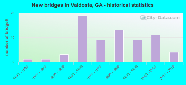
- New bridges - historical statistics
- 11930-1939
- 11940-1949
- 31950-1959
- 191960-1969
- 91970-1979
- 131980-1989
- 91990-1999
- 112000-2009
- 42010-2019

- Reconstructed bridges - Historical Statistics
- 21960-1969
- 01970-1979
- 11980-1989
- 81990-1999


- Bridge Condition - Deck
- 7.0%Very good
- 81.4%Good
- 4.7%Satisfactory
- 7.0%Fair

- Bridge Condition - Superstructure
- 34.9%Very good
- 60.5%Good
- 4.7%Satisfactory

- Bridge Condition - Substructure
- 4.7%Very good
- 90.7%Good
- 4.7%Fair

- Bridge Condition - Channel
- 40.0%Very good
- 41.8%Good
- 10.9%Satisfactory
- 5.5%Fair
- 1.8%Poor

- Bridge Condition - Culverts
- 92.6%Good
- 7.4%Satisfactory
Find on map >> Show street view
Structure Number: 1855034, Location: APP 6 MI NW OF VALDOSTA (Lat: 30.893808, Lng: -83.366458), Route carried "on" structure: County highway 775, Year Built: 1985, Status: Open, Structure Length: 3.66m (12.01ft), Average Daily Traffic: 490 (year 2012), Truck Traffic: 1%, Average Future Daily Traffic: 735 (year 2032), Design Load: HS 20, Features Intersected: FRANKS CREEK, Facility Carried by Structure: SHILOH ROAD
Minimum Vertical Clearance: 30+ m (98+ ft), Kilometerpoint: 1.609, Lanes on structure: 2, Base Highway Network: Yes, Owner: County Highway Agency, Approaching Roadway Width: 6.7m (22.0ft), Material/Design: Concrete, Design/Construction: Tee Beam, Number Of Spans In Main Unit: 4, Length of Maximum Span: 9.1m (29.9ft), Curb-To-Curb Width: 12.6m (41.3ft), Out-to-Out Width: 13.2m (43.3ft)
Condition: Deck: Good, Superstructure: Good, Substructure: Good, Channel: Very good, Operating Rating: 44.4 metric tons, Method Used To Determine Operating Rating: Load Factor (LF), Inventory Rating: 26.3 metric tons, Method Used To Determine Inventory Rating: Load Factor (LF), Structural Evaluation: Equal to present minimum criteria, Deck Geometry: Superior to present desirable criteria, Waterway Adequacy: Equal to present desirable criteria, Approach Roadway Alignment: Equal to present desirable criteria, Designated Inspection Frequency: Every 24 months, Inspection Date: November 2021, Bridge Improvement Cost: $469,000, Roadway Improvement Cost: $47,000, Total Project Cost: $703,000, Deck Structure Type: Concrete Cast-file-Place
Find on map >> Show street view
Structure Number: 1855041, Location: VALDOSTA - WEST SECTION (Lat: 30.833639, Lng: -83.303297), Route carried "on" structure: City street 542, Year Built: 1980, Status: Open, Structure Length: 0.64m (2.10ft), Average Daily Traffic: 1,570 (year 2012), Truck Traffic: 1%, Average Future Daily Traffic: 2,355 (year 2032), Design Load: H 15, Features Intersected: SUGAR CREEK, Facility Carried by Structure: W MAGNOLIA ROAD
Minimum Vertical Clearance: 30+ m (98+ ft), Kilometerpoint: 1.609, Lanes on structure: 2, Base Highway Network: Yes, Owner: City or Municipal Highway Agency, Approaching Roadway Width: 7.9m (25.9ft), Material/Design: Concrete, Design/Construction: Culvert, Number Of Spans In Main Unit: 2, Length of Maximum Span: 3.0m (9.8ft), Curb or Sidewalk Widths: Left: 0.2m (0.7ft), Right: 0.2m (0.7ft)
Condition: Channel: Good, Culverts: Good, Operating Rating: 41.7 metric tons, Method Used To Determine Operating Rating: Field evaluation and documented engineering judgment, Inventory Rating: 24.4 metric tons, Method Used To Determine Inventory Rating: Field evaluation and documented engineering judgment, Structural Evaluation: Equal to present minimum criteria, Waterway Adequacy: Better than present minimum criteria, Approach Roadway Alignment: Equal to present desirable criteria, Designated Inspection Frequency: Every 24 months, Inspection Date: January 2022, Bridge Improvement Cost: $82,000, Roadway Improvement Cost: $8,000, Total Project Cost: $123,000
Find on map >> Show street view
Structure Number: 1855042, Location: VALDOSTA -WEST SECTION (Lat: 30.834319, Lng: -83.287958), Route carried "on" structure: City street 830, Year Built: 1980, Status: Open, Structure Length: 0.70m (2.30ft), Average Daily Traffic: 1,570 (year 2012), Truck Traffic: 1%, Average Future Daily Traffic: 2,355 (year 2032), Design Load: HS 20+Mod, Features Intersected: SUGAR CREEK, Facility Carried by Structure: THIRD AVENUE
Minimum Vertical Clearance: 30+ m (98+ ft), Kilometerpoint: 0.000, Lanes on structure: 2, Base Highway Network: Yes, Owner: City or Municipal Highway Agency, Approaching Roadway Width: 4.9m (16.1ft), Skew: 2 degrees, Material/Design: Concrete, Design/Construction: Culvert, Number Of Spans In Main Unit: 2, Length of Maximum Span: 3.4m (11.2ft), Curb-To-Curb Width: 9.9m (32.5ft), Out-to-Out Width: 10.8m (35.4ft)
Condition: Channel: Good, Culverts: Good, Operating Rating: 55.3 metric tons, Method Used To Determine Operating Rating: Field evaluation and documented engineering judgment, Inventory Rating: 32.6 metric tons, Method Used To Determine Inventory Rating: Field evaluation and documented engineering judgment, Structural Evaluation: Better than present minimum criteria, Deck Geometry: Somewhat better than minimum adequacy, Waterway Adequacy: Better than present minimum criteria, Approach Roadway Alignment: Equal to present desirable criteria, Designated Inspection Frequency: Every 24 months, Inspection Date: January 2022, Bridge Improvement Cost: $90,000, Roadway Improvement Cost: $9,000, Total Project Cost: $135,000
Find on map >> Show street view
Structure Number: 1855044, Location: 7 MI E OF VALDOSTA (Lat: 30.829919, Lng: -83.228019), Route carried "on" structure: US 41, Year Built: 1989, Status: Open, Structure Length: 5.00m (16.40ft), Average Daily Traffic: 8,500 (year 2012), Truck Traffic: 1%, Average Future Daily Traffic: 12,750 (year 2032), Design Load: HS 20+Mod, Features Intersected: CSX RAILROAD, Facility Carried by Structure: INNER PERIMETER- U
Minimum Vertical Clearance: 30+ m (98+ ft), Kilometerpoint: 25.750, Lanes on structure: 4, Base Highway Network: Yes, Owner: State Highway Agency, Approaching Roadway Width: 9.8m (32.2ft), Material/Design: Prestressed concrete, Design/Construction: Stringer/Multi-beam, Number Of Spans In Main Unit: 3, Length of Maximum Span: 21.0m (68.9ft), Curb-To-Curb Width: 21.9m (71.9ft), Out-to-Out Width: 23.0m (75.5ft)
Condition: Deck: Good, Superstructure: Very good, Substructure: Good, Operating Rating: 73.4 metric tons, Method Used To Determine Operating Rating: Load Factor (LF), Inventory Rating: 43.5 metric tons, Method Used To Determine Inventory Rating: Load Factor (LF), Structural Evaluation: Better than present minimum criteria, Deck Geometry: Superior to present desirable criteria, Underclear: Superior to present desirable criteria, Approach Roadway Alignment: Equal to present desirable criteria, Designated Inspection Frequency: Every 24 months, Inspection Date: December 2021, Bridge Improvement Cost: $1,020,000, Roadway Improvement Cost: $102,000, Total Project Cost: $1,531,000, Deck Structure Type: Concrete Cast-file-Place
Find on map >> Show street view
Structure Number: 1855045, Location: 7 MI E OF VALDOSTA (Lat: 30.820750, Lng: -83.229439), Route carried "on" structure: US 41, Year Built: 1989, Status: Open, Structure Length: 1.52m (4.99ft), Average Daily Traffic: 6,950 (year 2012), Truck Traffic: 1%, Average Future Daily Traffic: 10,425 (year 2032), Design Load: HS 20+Mod, Features Intersected: KNIGHT CREEK, Facility Carried by Structure: INNER PERIMETER RD
Minimum Vertical Clearance: 30+ m (98+ ft), Kilometerpoint: 24.140, Lanes on structure: 4, Base Highway Network: Yes, Owner: State Highway Agency, Approaching Roadway Width: 18.9m (62.0ft), Skew: 13 degrees, Material/Design: Concrete, Design/Construction: Culvert, Number Of Spans In Main Unit: 4, Length of Maximum Span: 3.7m (12.1ft)
Condition: Channel: Very good, Culverts: Good, Operating Rating: 55.3 metric tons, Method Used To Determine Operating Rating: Field evaluation and documented engineering judgment, Inventory Rating: 32.6 metric tons, Method Used To Determine Inventory Rating: Field evaluation and documented engineering judgment, Structural Evaluation: Better than present minimum criteria, Waterway Adequacy: Equal to present desirable criteria, Approach Roadway Alignment: Equal to present desirable criteria, Designated Inspection Frequency: Every 24 months, Inspection Date: December 2021, Bridge Improvement Cost: $302,000, Roadway Improvement Cost: $30,000, Total Project Cost: $453,000
Find on map >> Show street view
Structure Number: 1855046, Location: 8 MI E OF VALDOSTA (Lat: 30.804789, Lng: -83.235108), Route carried "on" structure: US 41, Year Built: 1987, Status: Open, Structure Length: 4.88m (16.01ft), Average Daily Traffic: 6,050 (year 2012), Truck Traffic: 1%, Average Future Daily Traffic: 9,075 (year 2032), Design Load: HS 20, Features Intersected: MUD CREEK, Facility Carried by Structure: INNER PERIMETER RD
Minimum Vertical Clearance: 30+ m (98+ ft), Kilometerpoint: 22.531, Lanes on structure: 2, Base Highway Network: Yes, Owner: State Highway Agency, Approaching Roadway Width: 9.1m (29.9ft), Skew: 10 degrees, Material/Design: Concrete, Design/Construction: Tee Beam, Number Of Spans In Main Unit: 4, Length of Maximum Span: 12.2m (40.0ft), Curb-To-Curb Width: 11.7m (38.4ft), Out-to-Out Width: 12.6m (41.3ft)
Condition: Deck: Good, Superstructure: Good, Substructure: Good, Channel: Very good, Operating Rating: 58.9 metric tons, Method Used To Determine Operating Rating: Load Factor (LF), Inventory Rating: 35.3 metric tons, Method Used To Determine Inventory Rating: Load Factor (LF), Structural Evaluation: Better than present minimum criteria, Deck Geometry: Better than present minimum criteria, Waterway Adequacy: Equal to present desirable criteria, Approach Roadway Alignment: Equal to present desirable criteria, Designated Inspection Frequency: Every 24 months, Inspection Date: December 2021, Bridge Improvement Cost: $625,000, Roadway Improvement Cost: $63,000, Total Project Cost: $938,000, Deck Structure Type: Concrete Cast-file-Place
Find on map >> Show street view
Structure Number: 1855047, Location: 8 MI E OF VALDOSTA (Lat: 30.804847, Lng: -83.235339), Route carried "on" structure: US 41, Year Built: 1987, Status: Open, Structure Length: 4.88m (16.01ft), Average Daily Traffic: 6,050 (year 2012), Truck Traffic: 1%, Average Future Daily Traffic: 9,075 (year 2032), Design Load: HS 20, Features Intersected: MUD CREEK, Facility Carried by Structure: INNER PERIMETER RD
Minimum Vertical Clearance: 30+ m (98+ ft), Kilometerpoint: 22.531, Lanes on structure: 2, Base Highway Network: Yes, Owner: State Highway Agency, Approaching Roadway Width: 9.1m (29.9ft), Skew: 10 degrees, Material/Design: Concrete, Design/Construction: Tee Beam, Number Of Spans In Main Unit: 4, Length of Maximum Span: 12.2m (40.0ft), Curb-To-Curb Width: 11.7m (38.4ft), Out-to-Out Width: 12.6m (41.3ft)
Condition: Deck: Good, Superstructure: Good, Substructure: Good, Channel: Very good, Operating Rating: 58.9 metric tons, Method Used To Determine Operating Rating: Load Factor (LF), Inventory Rating: 35.3 metric tons, Method Used To Determine Inventory Rating: Load Factor (LF), Structural Evaluation: Better than present minimum criteria, Deck Geometry: Better than present minimum criteria, Waterway Adequacy: Equal to present desirable criteria, Approach Roadway Alignment: Equal to present desirable criteria, Designated Inspection Frequency: Every 24 months, Inspection Date: December 2021, Bridge Improvement Cost: $625,000, Roadway Improvement Cost: $63,000, Total Project Cost: $938,000, Deck Structure Type: Concrete Cast-file-Place
Find on map >> Show street view
Structure Number: 185505, Location: 7 MI SE OF VALDOSTA (Lat: 30.751508, Lng: -83.192497), Route carried "on" structure: County highway 1, Year Built: 1991, Status: Open, Structure Length: 1.16m (3.81ft), Average Daily Traffic: 490 (year 2012), Truck Traffic: 15%, Average Future Daily Traffic: 735 (year 2032), Design Load: HS 20+Mod, Features Intersected: DASHER CREEK, Facility Carried by Structure: OLD LAKE PARK RD
Minimum Vertical Clearance: 30+ m (98+ ft), Kilometerpoint: 3.219, Lanes on structure: 2, Base Highway Network: Yes, Owner: County Highway Agency, Approaching Roadway Width: 7.0m (23.0ft), Skew: 4 degrees, Material/Design: Concrete, Design/Construction: Culvert, Number Of Spans In Main Unit: 3, Length of Maximum Span: 3.7m (12.1ft)
Condition: Channel: Good, Culverts: Good, Operating Rating: 55.3 metric tons, Method Used To Determine Operating Rating: Field evaluation and documented engineering judgment, Inventory Rating: 32.6 metric tons, Method Used To Determine Inventory Rating: Field evaluation and documented engineering judgment, Structural Evaluation: Better than present minimum criteria, Waterway Adequacy: Better than present minimum criteria, Approach Roadway Alignment: Equal to present desirable criteria, Designated Inspection Frequency: Every 24 months, Underwater Inspection Frequency: Every 60 months, Inspection Date: November 2021, Underwater Inspection Date: Febuary 2019, Bridge Improvement Cost: $148,000, Roadway Improvement Cost: $15,000, Total Project Cost: $223,000
Find on map >> Show street view
Structure Number: 1855051, Location: 3.5 MI E OF VALDOSTA (Lat: 30.900800, Lng: -83.232200), Route carried "on" structure: County highway 83, Year Built: 1990, Status: Open, Structure Length: 0.88m (2.89ft), Average Daily Traffic: 610 (year 2012), Truck Traffic: 1%, Average Future Daily Traffic: 915 (year 2032), Design Load: HS 20+Mod, Features Intersected: CHERRY CREEK, Facility Carried by Structure: STALLINGS ROAD
Minimum Vertical Clearance: 30+ m (98+ ft), Kilometerpoint: 1.609, Lanes on structure: 2, Base Highway Network: Yes, Owner: County Highway Agency, Approaching Roadway Width: 6.1m (20.0ft), Material/Design: Concrete, Design/Construction: Culvert, Number Of Spans In Main Unit: 3, Length of Maximum Span: 2.7m (8.9ft)
Condition: Channel: Good, Culverts: Good, Operating Rating: 55.3 metric tons, Method Used To Determine Operating Rating: Field evaluation and documented engineering judgment, Inventory Rating: 32.6 metric tons, Method Used To Determine Inventory Rating: Field evaluation and documented engineering judgment, Structural Evaluation: Better than present minimum criteria, Waterway Adequacy: Better than present minimum criteria, Approach Roadway Alignment: Better than present minimum criteria, Designated Inspection Frequency: Every 24 months, Inspection Date: January 2022, Bridge Improvement Cost: $113,000, Roadway Improvement Cost: $11,000, Total Project Cost: $170,000
Find on map >> Show street view
Structure Number: 1855052, Location: SOUTH VALDOSTA (Lat: 30.818139, Lng: -83.272658), Route carried "on" structure: City street 4906, Year Built: 1983, Status: Open, Structure Length: 0.79m (2.59ft), Average Daily Traffic: 2,210 (year 2012), Truck Traffic: 1%, Average Future Daily Traffic: 3,315 (year 2032), Design Load: HS 20+Mod, Features Intersected: DUKES BAY CANAL, Facility Carried by Structure: DAMPIER ROAD
Minimum Vertical Clearance: 30+ m (98+ ft), Kilometerpoint: 1.609, Lanes on structure: 2, Base Highway Network: Yes, Owner: City or Municipal Highway Agency, Approaching Roadway Width: 11.0m (36.1ft), Material/Design: Concrete, Design/Construction: Culvert, Number Of Spans In Main Unit: 3, Length of Maximum Span: 2.4m (7.9ft)
Condition: Channel: Good, Culverts: Good, Operating Rating: 55.3 metric tons, Method Used To Determine Operating Rating: Field evaluation and documented engineering judgment, Inventory Rating: 32.6 metric tons, Method Used To Determine Inventory Rating: Field evaluation and documented engineering judgment, Structural Evaluation: Better than present minimum criteria, Waterway Adequacy: Equal to present minimum criteria, Approach Roadway Alignment: Better than present minimum criteria, Designated Inspection Frequency: Every 24 months, Inspection Date: January 2022, Bridge Improvement Cost: $102,000, Roadway Improvement Cost: $10,000, Total Project Cost: $152,000
Find on map >> Show street view
Structure Number: 1855053, Location: NORTHSIDE CITY LIMITS VAL (Lat: 30.863478, Lng: -83.292358), Route carried "on" structure: City street 4906, Year Built: 1998, Status: Open, Structure Length: 0.85m (2.79ft), Average Daily Traffic: 7,770 (year 2012), Truck Traffic: 2%, Average Future Daily Traffic: 11,655 (year 2032), Design Load: HS 20+Mod, Features Intersected: TWO MILE BRANCH, Facility Carried by Structure: CS 1014 NORTH OAK
Minimum Vertical Clearance: 30+ m (98+ ft), Kilometerpoint: 6.437, Lanes on structure: 2, Base Highway Network: Yes, Owner: City or Municipal Highway Agency, Approaching Roadway Width: 6.4m (21.0ft), Material/Design: Concrete, Design/Construction: Culvert, Number Of Spans In Main Unit: 3, Length of Maximum Span: 2.4m (7.9ft), Curb or Sidewalk Widths: Left: 0.0m, Right: 1.8m (5.9ft)
Condition: Channel: Very good, Culverts: Good, Operating Rating: 55.3 metric tons, Method Used To Determine Operating Rating: Field evaluation and documented engineering judgment, Inventory Rating: 32.6 metric tons, Method Used To Determine Inventory Rating: Field evaluation and documented engineering judgment, Structural Evaluation: Better than present minimum criteria, Waterway Adequacy: Better than present minimum criteria, Approach Roadway Alignment: Equal to present desirable criteria, Designated Inspection Frequency: Every 24 months, Inspection Date: January 2022, Bridge Improvement Cost: $109,000, Roadway Improvement Cost: $11,000, Total Project Cost: $164,000
Find on map >> Show street view
Structure Number: 1855054, Location: VALDOSTA - SW SECTION (Lat: 30.794558, Lng: -83.285269), Route carried "on" structure: City street 4915, Year Built: 1998, Status: Open, Structure Length: 3.66m (12.01ft), Average Daily Traffic: 3,610 (year 2012), Truck Traffic: 1%, Average Future Daily Traffic: 5,415 (year 2032), Design Load: HS 20+Mod, Features Intersected: MUD CREEK, Facility Carried by Structure: CLYATTVILLE ROAD
Minimum Vertical Clearance: 30+ m (98+ ft), Kilometerpoint: 3.219, Lanes on structure: 4, Base Highway Network: Yes, Owner: City or Municipal Highway Agency, Approaching Roadway Width: 14.0m (45.9ft), Skew: 22 degrees, Material/Design: Concrete, Design/Construction: Tee Beam, Number Of Spans In Main Unit: 3, Length of Maximum Span: 12.2m (40.0ft), Curb-To-Curb Width: 26.8m (87.9ft), Out-to-Out Width: 27.8m (91.2ft)
Condition: Deck: Good, Superstructure: Good, Substructure: Good, Channel: Very good, Operating Rating: 77.1 metric tons, Method Used To Determine Operating Rating: Load Factor (LF), Inventory Rating: 46.2 metric tons, Method Used To Determine Inventory Rating: Load Factor (LF), Structural Evaluation: Better than present minimum criteria, Deck Geometry: Superior to present desirable criteria, Waterway Adequacy: Equal to present desirable criteria, Approach Roadway Alignment: Equal to present desirable criteria, Designated Inspection Frequency: Every 24 months, Inspection Date: December 2021, Bridge Improvement Cost: $725,000, Roadway Improvement Cost: $72,000, Total Project Cost: $1,087,000, Deck Structure Type: Concrete Cast-file-Place
Find on map >> Show street view
Structure Number: 1855055, Location: NORTH WEST VALDOSTA (Lat: 30.836828, Lng: -83.301247), Route carried "on" structure: City street 555, Year Built: 1999, Status: Open, Structure Length: 0.98m (3.22ft), Average Daily Traffic: 6,590 (year 2012), Truck Traffic: 1%, Average Future Daily Traffic: 9,885 (year 2032), Design Load: HS 20+Mod, Features Intersected: SUGAR CREEK TRIB, Facility Carried by Structure: HIGHTOWER STREET
Minimum Vertical Clearance: 30+ m (98+ ft), Kilometerpoint: 0.000, Lanes on structure: 2, Base Highway Network: Yes, Owner: City or Municipal Highway Agency, Approaching Roadway Width: 6.1m (20.0ft), Material/Design: Concrete, Design/Construction: Culvert, Number Of Spans In Main Unit: 3, Length of Maximum Span: 3.0m (9.8ft), Curb or Sidewalk Widths: Left: 0.0m, Right: 1.2m (3.9ft)
Condition: Channel: Satisfactory, Culverts: Good, Operating Rating: 55.3 metric tons, Method Used To Determine Operating Rating: Field evaluation and documented engineering judgment, Inventory Rating: 32.6 metric tons, Method Used To Determine Inventory Rating: Field evaluation and documented engineering judgment, Structural Evaluation: Better than present minimum criteria, Waterway Adequacy: Better than present minimum criteria, Approach Roadway Alignment: Equal to present desirable criteria, Designated Inspection Frequency: Every 24 months, Inspection Date: January 2022, Bridge Improvement Cost: $125,000, Roadway Improvement Cost: $13,000, Total Project Cost: $188,000
Find on map >> Show street view
Structure Number: 1855058, Location: VALDOSTA - NW SECTION (Lat: 30.863297, Lng: -83.301878), Route carried "on" structure: City street 962, Year Built: 1999, Status: Open, Structure Length: 0.91m (2.99ft), Average Daily Traffic: 2,240 (year 2012), Truck Traffic: 1%, Average Future Daily Traffic: 3,360 (year 2032), Design Load: HS 20+Mod, Features Intersected: TWO MILE CREEK
Minimum Vertical Clearance: 30+ m (98+ ft), Kilometerpoint: 0.000, Lanes on structure: 2, Base Highway Network: Yes, Owner: City or Municipal Highway Agency, Approaching Roadway Width: 7.6m (24.9ft), Skew: 3 degrees, Material/Design: Concrete, Design/Construction: Culvert, Number Of Spans In Main Unit: 3, Length of Maximum Span: 2.7m (8.9ft), Curb or Sidewalk Widths: Left: 0.2m (0.7ft), Right: 0.2m (0.7ft)
Condition: Channel: Very good, Culverts: Good, Operating Rating: 55.3 metric tons, Method Used To Determine Operating Rating: Field evaluation and documented engineering judgment, Inventory Rating: 32.6 metric tons, Method Used To Determine Inventory Rating: Field evaluation and documented engineering judgment, Structural Evaluation: Better than present minimum criteria, Waterway Adequacy: Equal to present minimum criteria, Approach Roadway Alignment: Equal to present desirable criteria, Designated Inspection Frequency: Every 24 months, Underwater Inspection Frequency: Every 60 months, Inspection Date: January 2022, Underwater Inspection Date: Febuary 2019, Bridge Improvement Cost: $117,000, Roadway Improvement Cost: $12,000, Total Project Cost: $176,000
Find on map >> Show street view
Structure Number: 1855059, Location: APP 4 MI NW OF VALDOSTA (Lat: 30.851700, Lng: -83.342039), Route carried "on" structure: State highway 133, Year Built: 2000, Status: Open, Structure Length: 8.53m (27.99ft), Average Daily Traffic: 11,020 (year 2012), Truck Traffic: 9%, Average Future Daily Traffic: 16,530 (year 2032), Design Load: HS 20+Mod, Features Intersected: WITHLACOOCHEE RIVER O/F
Minimum Vertical Clearance: 30+ m (98+ ft), Kilometerpoint: 4.828, Lanes on structure: 4, Base Highway Network: Yes, Owner: State Highway Agency, Approaching Roadway Width: 25.9m (85.0ft), Skew: 20 degrees, Material/Design: Prestressed concrete, Design/Construction: Stringer/Multi-beam, Number Of Spans In Main Unit: 4, Length of Maximum Span: 21.3m (69.9ft), Curb-To-Curb Width: 26.8m (87.9ft), Out-to-Out Width: 27.8m (91.2ft)
Condition: Deck: Good, Superstructure: Very good, Substructure: Good, Channel: Very good, Operating Rating: 59.8 metric tons, Method Used To Determine Operating Rating: Load Factor (LF), Inventory Rating: 32.6 metric tons, Method Used To Determine Inventory Rating: Load Factor (LF), Structural Evaluation: Better than present minimum criteria, Deck Geometry: Superior to present desirable criteria, Waterway Adequacy: Equal to present minimum criteria, Approach Roadway Alignment: Equal to present desirable criteria, Designated Inspection Frequency: Every 24 months, Inspection Date: December 2021, Bridge Improvement Cost: $1,691,000, Roadway Improvement Cost: $169,000, Total Project Cost: $2,536,000, Deck Structure Type: Concrete Cast-file-Place
Find on map >> Show street view
Structure Number: 185506, Location: APP 4 MI NW OF VALDOSTA (Lat: 30.850200, Lng: -83.339747), Route carried "on" structure: State highway 133, Year Built: 2000, Status: Open, Structure Length: 14.02m (46.00ft), Average Daily Traffic: 11,020 (year 2012), Truck Traffic: 9%, Average Future Daily Traffic: 16,530 (year 2032), Design Load: HS 20+Mod, Features Intersected: WITHLACOOCHEE RIVER
Minimum Vertical Clearance: 30+ m (98+ ft), Kilometerpoint: 4.828, Lanes on structure: 4, Base Highway Network: Yes, Owner: State Highway Agency, Approaching Roadway Width: 25.0m (82.0ft), Skew: 21 degrees, Material/Design: Prestressed concrete, Design/Construction: Stringer/Multi-beam, Number Of Spans In Main Unit: 5, Length of Maximum Span: 42.7m (140.1ft), Curb-To-Curb Width: 26.8m (87.9ft), Out-to-Out Width: 27.8m (91.2ft)
Condition: Deck: Good, Superstructure: Very good, Substructure: Good, Channel: Good, Operating Rating: 39.0 metric tons, Method Used To Determine Operating Rating: Load Factor (LF), Inventory Rating: 22.6 metric tons, Method Used To Determine Inventory Rating: Load Factor (LF), Structural Evaluation: Somewhat better than minimum adequacy, Deck Geometry: Superior to present desirable criteria, Waterway Adequacy: Equal to present desirable criteria, Approach Roadway Alignment: Equal to present desirable criteria, Designated Inspection Frequency: Every 24 months, Inspection Date: December 2021, Bridge Improvement Cost: $2,778,000, Roadway Improvement Cost: $278,000, Total Project Cost: $4,166,000, Deck Structure Type: Concrete Cast-file-Place
Find on map >> Show street view
Structure Number: 1855066, Location: SE VALDOSTA-LITTLE MIAMI (Lat: 30.813578, Lng: -83.269539), Route carried "on" structure: City street 572, Year Built: 2004, Status: Open, Structure Length: 1.55m (5.09ft), Average Daily Traffic: 380 (year 2012), Truck Traffic: 1%, Average Future Daily Traffic: 570 (year 2032), Features Intersected: DUKES BAY CANAL, Facility Carried by Structure: SMITH AVENUE
Minimum Vertical Clearance: 30+ m (98+ ft), Kilometerpoint: 0.000, Lanes on structure: 2, Base Highway Network: Yes, Owner: City or Municipal Highway Agency, Approaching Roadway Width: 5.5m (18.0ft), Material/Design: Steel, Design/Construction: Truss - Thru, Number Of Spans In Main Unit: 1, Length of Maximum Span: 15.5m (50.9ft), Curb-To-Curb Width: 7.3m (24.0ft), Out-to-Out Width: 8.0m (26.2ft)
Condition: Deck: Good, Superstructure: Good, Substructure: Good, Channel: Good, Operating Rating: 59.8 metric tons, Method Used To Determine Operating Rating: Load Factor (LF), Inventory Rating: 35.3 metric tons, Method Used To Determine Inventory Rating: Load Factor (LF), Structural Evaluation: Better than present minimum criteria, Deck Geometry: Somewhat better than minimum adequacy, Waterway Adequacy: Equal to present desirable criteria, Approach Roadway Alignment: Equal to present minimum criteria, Designated Inspection Frequency: Every 24 months, Critical Feature Inspection Frequency: Every 24 months, Inspection Date: January 2022, Critical Feature Inspection Date: January 2021, Bridge Improvement Cost: $199,000, Roadway Improvement Cost: $20,000, Total Project Cost: $299,000, Deck Structure Type: Concrete Cast-file-Place
Find on map >> Show street view
Structure Number: 1855067, Location: APP 7 MI N OF VALDOSTA (Lat: 30.937228, Lng: -83.327669), Route carried "on" structure: County highway 31, Year Built: 2006, Status: Open, Structure Length: 1.83m (6.00ft), Average Daily Traffic: 60 (year 2012), Truck Traffic: 1%, Average Future Daily Traffic: 90 (year 2032), Features Intersected: BAY BRANCH, Facility Carried by Structure: DOOD ROAD
Minimum Vertical Clearance: 30+ m (98+ ft), Kilometerpoint: 0.000, Lanes on structure: 2, Base Highway Network: Yes, Owner: County Highway Agency, Approaching Roadway Width: 5.8m (19.0ft), Material/Design: Concrete, Design/Construction: Slab, Number Of Spans In Main Unit: 3, Length of Maximum Span: 6.1m (20.0ft), Curb-To-Curb Width: 7.3m (24.0ft), Out-to-Out Width: 8.1m (26.6ft)
Condition: Deck: Very good, Superstructure: Very good, Substructure: Good, Channel: Very good, Operating Rating: 54.4 metric tons, Method Used To Determine Operating Rating: Load Factor (LF), Inventory Rating: 32.6 metric tons, Method Used To Determine Inventory Rating: Load Factor (LF), Structural Evaluation: Better than present minimum criteria, Deck Geometry: Equal to present minimum criteria, Waterway Adequacy: Better than present minimum criteria, Approach Roadway Alignment: Equal to present desirable criteria, Designated Inspection Frequency: Every 24 months, Inspection Date: January 2022, Bridge Improvement Cost: $234,000, Roadway Improvement Cost: $23,000, Total Project Cost: $352,000, Deck Structure Type: Concrete Precast Panels
Find on map >> Show street view
Structure Number: 185507, Location: APP 3 MI SW OF BARRETTS (Lat: 30.990128, Lng: -83.244950), Route carried "on" structure: County highway 577, Year Built: 2005, Status: Open, Structure Length: 5.85m (19.19ft), Average Daily Traffic: 2,590 (year 2012), Truck Traffic: 1%, Average Future Daily Traffic: 3,885 (year 2032), Design Load: HS 20+Mod, Features Intersected: CAT CREEK, Facility Carried by Structure: CAT CREEK ROAD
Minimum Vertical Clearance: 30+ m (98+ ft), Kilometerpoint: 6.437, Lanes on structure: 2, Base Highway Network: Yes, Owner: County Highway Agency, Approaching Roadway Width: 8.5m (27.9ft), Material/Design: Concrete, Design/Construction: Stringer/Multi-beam, Number Of Spans In Main Unit: 5, Length of Maximum Span: 11.9m (39.0ft), Curb-To-Curb Width: 12.0m (39.4ft), Out-to-Out Width: 13.1m (43.0ft)
Condition: Deck: Good, Superstructure: Good, Substructure: Good, Channel: Good, Operating Rating: 68.9 metric tons, Method Used To Determine Operating Rating: Load Factor (LF), Inventory Rating: 43.5 metric tons, Method Used To Determine Inventory Rating: Load Factor (LF), Structural Evaluation: Better than present minimum criteria, Deck Geometry: Somewhat better than minimum adequacy, Waterway Adequacy: Equal to present minimum criteria, Approach Roadway Alignment: Equal to present desirable criteria, Designated Inspection Frequency: Every 24 months, Inspection Date: January 2022, Bridge Improvement Cost: $750,000, Roadway Improvement Cost: $75,000, Total Project Cost: $1,125,000, Deck Structure Type: Concrete Cast-file-Place
Find on map >> Show street view
Structure Number: 1855074, Location: VALDOSTA - NE SECTION (Lat: 30.848628, Lng: -83.278178), Route carried "on" structure: City street 1006, Year Built: 2007, Status: Open, Structure Length: 0.73m (2.40ft), Average Daily Traffic: 1,980 (year 2012), Truck Traffic: 1%, Average Future Daily Traffic: 2,970 (year 2032), Design Load: HS 20+Mod, Features Intersected: ONE MILE BRANCH
Minimum Vertical Clearance: 30+ m (98+ ft), Kilometerpoint: 3.219, Lanes on structure: 2, Base Highway Network: Yes, Owner: City or Municipal Highway Agency, Approaching Roadway Width: 11.0m (36.1ft), Skew: 4 degrees, Material/Design: Concrete, Design/Construction: Culvert, Number Of Spans In Main Unit: 2, Length of Maximum Span: 3.4m (11.2ft), Curb or Sidewalk Widths: Left: 1.5m (4.9ft), Right: 1.5m (4.9ft)
Condition: Channel: Very good, Culverts: Good, Operating Rating: 55.3 metric tons, Method Used To Determine Operating Rating: Field evaluation and documented engineering judgment, Inventory Rating: 32.6 metric tons, Method Used To Determine Inventory Rating: Field evaluation and documented engineering judgment, Structural Evaluation: Better than present minimum criteria, Waterway Adequacy: Better than present minimum criteria, Approach Roadway Alignment: Better than present minimum criteria, Designated Inspection Frequency: Every 24 months, Inspection Date: January 2022, Bridge Improvement Cost: $94,000, Roadway Improvement Cost: $9,000, Total Project Cost: $141,000
Find on map >> Show street view
Structure Number: 1855076, Location: WEST SIDE OF REMERTON (Lat: 30.840419, Lng: -83.306578), Route carried "on" structure: County highway 555, Year Built: 1990, Status: Open, Structure Length: 0.67m (2.20ft), Average Daily Traffic: 3,950 (year 2012), Truck Traffic: 1%, Average Future Daily Traffic: 5,925 (year 2032), Design Load: H 15, Features Intersected: ONE MILE BRANCH, Facility Carried by Structure: ONE MILE BRANCH RO
Minimum Vertical Clearance: 30+ m (98+ ft), Kilometerpoint: 1.609, Lanes on structure: 2, Base Highway Network: Yes, Owner: City or Municipal Highway Agency, Approaching Roadway Width: 6.1m (20.0ft), Skew: 1 degrees, Material/Design: Concrete, Design/Construction: Culvert, Number Of Spans In Main Unit: 2, Length of Maximum Span: 3.0m (9.8ft)
Condition: Channel: Very good, Culverts: Good, Operating Rating: 55.3 metric tons, Method Used To Determine Operating Rating: Field evaluation and documented engineering judgment, Inventory Rating: 32.6 metric tons, Method Used To Determine Inventory Rating: Field evaluation and documented engineering judgment, Structural Evaluation: Better than present minimum criteria, Waterway Adequacy: Better than present minimum criteria, Approach Roadway Alignment: Better than present minimum criteria, Designated Inspection Frequency: Every 24 months, Inspection Date: January 2022, Bridge Improvement Cost: $86,000, Roadway Improvement Cost: $9,000, Total Project Cost: $129,000
Find on map >> Show street view
Structure Number: 1855078, Location: 5 MILES NORTH OF VALDOSTA (Lat: 30.912869, Lng: -83.263378), Route carried "on" structure: County highway 1268, Year Built: 2001, Status: Open, Structure Length: 0.98m (3.22ft), Average Daily Traffic: 2,620 (year 2012), Truck Traffic: 1%, Average Future Daily Traffic: 3,930 (year 2032), Design Load: HS 20+Mod, Features Intersected: CHERRY CREEK
Minimum Vertical Clearance: 30+ m (98+ ft), Kilometerpoint: 0.000, Lanes on structure: 2, Base Highway Network: Yes, Owner: County Highway Agency, Approaching Roadway Width: 8.2m (26.9ft), Material/Design: Concrete, Design/Construction: Culvert, Number Of Spans In Main Unit: 3, Length of Maximum Span: 3.0m (9.8ft)
Condition: Channel: Good, Culverts: Good, Operating Rating: 55.3 metric tons, Method Used To Determine Operating Rating: Field evaluation and documented engineering judgment, Inventory Rating: 32.6 metric tons, Method Used To Determine Inventory Rating: Field evaluation and documented engineering judgment, Structural Evaluation: Better than present minimum criteria, Waterway Adequacy: Better than present minimum criteria, Approach Roadway Alignment: Better than present minimum criteria, Designated Inspection Frequency: Every 24 months, Inspection Date: January 2022, Bridge Improvement Cost: $125,000, Roadway Improvement Cost: $13,000, Total Project Cost: $188,000
Find on map >> Show street view
Structure Number: 1855079, Location: 5 MIILE NORTH OF VALDOSTA (Lat: 30.933128, Lng: -83.288919), Route carried "on" structure: County highway 781, Year Built: 2009, Status: Open, Structure Length: 18.29m (60.01ft), Average Daily Traffic: 2,280 (year 2012), Truck Traffic: 1%, Average Future Daily Traffic: 3,420 (year 2032), Design Load: HS 20+Mod, Features Intersected: WITHLACOOCHEE RIVER, Facility Carried by Structure: STATEN ROAD
Minimum Vertical Clearance: 30+ m (98+ ft), Kilometerpoint: 4.828, Lanes on structure: 2, Base Highway Network: Yes, Owner: County Highway Agency, Approaching Roadway Width: 8.5m (27.9ft), Skew: 9 degrees, Material/Design: Concrete, Design/Construction: Stringer/Multi-beam, Number Of Spans In Main Unit: 6, Length of Maximum Span: 36.6m (120.1ft), Curb-To-Curb Width: 12.2m (40.0ft), Out-to-Out Width: 13.2m (43.3ft)
Condition: Deck: Good, Superstructure: Very good, Substructure: Good, Channel: Very good, Operating Rating: 61.6 metric tons, Method Used To Determine Operating Rating: Load Factor (LF), Inventory Rating: 37.1 metric tons, Method Used To Determine Inventory Rating: Load Factor (LF), Structural Evaluation: Better than present minimum criteria, Deck Geometry: Equal to present minimum criteria, Waterway Adequacy: Equal to present desirable criteria, Approach Roadway Alignment: Equal to present desirable criteria, Designated Inspection Frequency: Every 24 months, Inspection Date: January 2022, Bridge Improvement Cost: $2,344,000, Roadway Improvement Cost: $234,000, Total Project Cost: $3,516,000, Deck Structure Type: Concrete Cast-file-Place
Find on map >> Show street view
Structure Number: 185508, Location: 5.2 MILE NORTH OF VALDOST (Lat: 30.935619, Lng: -83.289178), Route carried "on" structure: County highway 781, Year Built: 2009, Status: Open, Structure Length: 10.97m (35.99ft), Average Daily Traffic: 2,280 (year 2012), Truck Traffic: 1%, Average Future Daily Traffic: 3,420 (year 2032), Design Load: HS 20+Mod, Features Intersected: WITHLACOOCHEE RIVER O/F, Facility Carried by Structure: STATEN ROAD
Minimum Vertical Clearance: 30+ m (98+ ft), Kilometerpoint: 4.828, Lanes on structure: 2, Base Highway Network: Yes, Owner: County Highway Agency, Approaching Roadway Width: 12.5m (41.0ft), Material/Design: Concrete, Design/Construction: Stringer/Multi-beam, Number Of Spans In Main Unit: 9, Length of Maximum Span: 12.2m (40.0ft), Curb-To-Curb Width: 12.2m (40.0ft), Out-to-Out Width: 13.0m (42.7ft)
Condition: Deck: Good, Superstructure: Very good, Substructure: Good, Channel: Very good, Operating Rating: 58.9 metric tons, Method Used To Determine Operating Rating: Allowable Stress (AS), Inventory Rating: 32.6 metric tons, Method Used To Determine Inventory Rating: Allowable Stress (AS), Structural Evaluation: Better than present minimum criteria, Deck Geometry: Equal to present minimum criteria, Waterway Adequacy: Equal to present desirable criteria, Approach Roadway Alignment: Equal to present desirable criteria, Designated Inspection Frequency: Every 24 months, Inspection Date: January 2022, Bridge Improvement Cost: $1,407,000, Roadway Improvement Cost: $141,000, Total Project Cost: $2,110,000, Deck Structure Type: Concrete Cast-file-Place
Find on map >> Show street view
Structure Number: 1855081, Location: 5 MILE NORTH OF VALDOSTA (Lat: 30.937639, Lng: -83.290289), Route carried "on" structure: County highway 781, Year Built: 2009, Status: Open, Structure Length: 6.10m (20.01ft), Average Daily Traffic: 2,280 (year 2012), Truck Traffic: 1%, Average Future Daily Traffic: 3,420 (year 2032), Design Load: HS 20+Mod, Features Intersected: WITHLACOOCHEE RIVER, Facility Carried by Structure: STATEN ROAD
Minimum Vertical Clearance: 30+ m (98+ ft), Kilometerpoint: 6.437, Lanes on structure: 2, Base Highway Network: Yes, Owner: County Highway Agency, Approaching Roadway Width: 12.5m (41.0ft), Material/Design: Concrete, Design/Construction: Stringer/Multi-beam, Number Of Spans In Main Unit: 5, Length of Maximum Span: 12.2m (40.0ft), Curb-To-Curb Width: 12.2m (40.0ft), Out-to-Out Width: 13.0m (42.7ft)
Condition: Deck: Good, Superstructure: Very good, Substructure: Good, Channel: Very good, Operating Rating: 58.9 metric tons, Method Used To Determine Operating Rating: Allowable Stress (AS), Inventory Rating: 32.6 metric tons, Method Used To Determine Inventory Rating: Allowable Stress (AS), Structural Evaluation: Better than present minimum criteria, Deck Geometry: Equal to present minimum criteria, Waterway Adequacy: Equal to present desirable criteria, Approach Roadway Alignment: Equal to present desirable criteria, Designated Inspection Frequency: Every 24 months, Inspection Date: January 2022, Bridge Improvement Cost: $781,000, Roadway Improvement Cost: $78,000, Total Project Cost: $1,172,000, Deck Structure Type: Concrete Cast-file-Place
Find on map >> Show street view
Structure Number: 1855085, Location: 8.1 MI N OF VALDOSTA (Lat: 30.949069, Lng: -83.272247), Route carried "on" structure: County highway 1268, Year Built: 2011, Status: Open, Structure Length: 21.34m (70.01ft), Average Daily Traffic: 490 (year 2012), Truck Traffic: 1%, Average Future Daily Traffic: 735 (year 2032), Design Load: HS 20+Mod, Features Intersected: WITHLACOOCHEE RIVER, Facility Carried by Structure: SKIPPER BRIDGE ROA
Minimum Vertical Clearance: 30+ m (98+ ft), Kilometerpoint: 4.828, Lanes on structure: 2, Base Highway Network: Yes, Owner: County Highway Agency, Approaching Roadway Width: 12.5m (41.0ft), Skew: 3 degrees, Material/Design: Prestressed concrete, Design/Construction: Stringer/Multi-beam, Number Of Spans In Main Unit: 7, Length of Maximum Span: 38.1m (125.0ft), Curb-To-Curb Width: 12.2m (40.0ft), Out-to-Out Width: 13.2m (43.3ft)
Condition: Deck: Good, Superstructure: Very good, Substructure: Good, Channel: Very good, Operating Rating: 78.9 metric tons, Method Used To Determine Operating Rating: Load Factor (LF), Inventory Rating: 33.5 metric tons, Method Used To Determine Inventory Rating: Load Factor (LF), Structural Evaluation: Better than present minimum criteria, Deck Geometry: Equal to present desirable criteria, Waterway Adequacy: Better than present minimum criteria, Approach Roadway Alignment: Equal to present desirable criteria, Designated Inspection Frequency: Every 24 months, Inspection Date: January 2022, Bridge Improvement Cost: $2,735,000, Roadway Improvement Cost: $274,000, Total Project Cost: $4,103,000, Deck Structure Type: Concrete Cast-file-Place
Find on map >> Show street view
Structure Number: 1855086, Location: VALDOSTA - SOUTH SECTION (Lat: 30.812200, Lng: -83.267153), Route carried "on" structure: City street 1191, Year Built: 2014, Status: Open, Structure Length: 0.64m (2.10ft), Average Daily Traffic: 950 (year 2010), Truck Traffic: 2%, Average Future Daily Traffic: 1,500 (year 2031), Design Load: HS 20+Mod, Features Intersected: DUKES BAY CANAL, Facility Carried by Structure: TUCKER ROAD
Minimum Vertical Clearance: 30+ m (98+ ft), Kilometerpoint: 1.609, Lanes on structure: 2, Base Highway Network: Yes, Owner: City or Municipal Highway Agency, Approaching Roadway Width: 6.4m (21.0ft), Skew: 1 degrees, Material/Design: Concrete, Design/Construction: Culvert, Number Of Spans In Main Unit: 2, Length of Maximum Span: 3.0m (9.8ft)
Condition: Channel: Very good, Culverts: Good, Operating Rating: 55.3 metric tons, Method Used To Determine Operating Rating: Field evaluation and documented engineering judgment, Inventory Rating: 32.6 metric tons, Method Used To Determine Inventory Rating: Field evaluation and documented engineering judgment, Structural Evaluation: Better than present minimum criteria, Waterway Adequacy: Better than present minimum criteria, Approach Roadway Alignment: Better than present minimum criteria, Designated Inspection Frequency: Every 24 months, Inspection Date: January 2022
Find on map >> Show street view
Structure Number: 1855087, Location: SW VALDOSTA (Lat: 30.826867, Lng: -83.288867), Route carried "on" structure: US 84, Year Built: 2014, Status: Open, Structure Length: 10.06m (33.01ft), Average Daily Traffic: 20,700 (year 2014), Truck Traffic: 45%, Average Future Daily Traffic: 29,850 (year 2034), Design Load: HS 20+Mod, Features Intersected: NORFOLK SOUTHERN RAILROA
Minimum Vertical Clearance: 30+ m (98+ ft), Kilometerpoint: 16.093, Lanes on structure: 4, Owner: State Highway Agency, Approaching Roadway Width: 19.5m (64.0ft), Skew: 2 degrees, Material/Design: Prestressed concrete, Design/Construction: Stringer/Multi-beam, Number Of Spans In Main Unit: 3, Length of Maximum Span: 33.5m (109.9ft), Curb or Sidewalk Widths: Left: 1.8m (5.9ft), Right: 1.8m (5.9ft), Curb-To-Curb Width: 15.8m (51.8ft), Out-to-Out Width: 20.2m (66.3ft)
Condition: Deck: Good, Superstructure: Good, Substructure: Very good, Operating Rating: 63.5 metric tons, Method Used To Determine Operating Rating: Load Factor (LF), Inventory Rating: 38.1 metric tons, Method Used To Determine Inventory Rating: Load Factor (LF), Structural Evaluation: Better than present minimum criteria, Deck Geometry: Meets minimum limits, Underclear: Superior to present desirable criteria, Approach Roadway Alignment: Equal to present desirable criteria, Length Of Structure Improvement: 12.07m (39.60ft), Designated Inspection Frequency: Every 24 months, Inspection Date: January 2022, Bridge Improvement Cost: $29,304,000, Roadway Improvement Cost: $2,930,000, Total Project Cost: $43,956,000 ( Estimate for 2014), Deck Structure Type: Concrete Cast-file-Place
Find on map >> Show street view
Structure Number: 1855093, Location: 5 MI N OF VALDOSTA (Lat: 30.894678, Lng: -83.355708), Route carried "on" structure: US 41, Year Built: 2019, Status: Open, Structure Length: 7.83m (25.69ft), Average Daily Traffic: 23,700 (year 2019), Truck Traffic: 11%, Average Future Daily Traffic: 35,100 (year 2039), Design Load: HS 20+Mod, Features Intersected: I-75 (EXIT 22)
Minimum Vertical Clearance: 5.43m (17.81ft), Kilometerpoint: 40.234, Lanes on structure: 4, Lanes under structure: 7, Base Highway Network: Yes, Owner: State Highway Agency, Approaching Roadway Width: 26.8m (87.9ft), Skew: 12 degrees, Material/Design: Prestressed concrete, Design/Construction: Stringer/Multi-beam, Number Of Spans In Main Unit: 2, Length of Maximum Span: 41.8m (137.1ft), Curb-To-Curb Width: 26.8m (87.9ft), Out-to-Out Width: 27.8m (91.2ft)
Condition: Deck: Very good, Superstructure: Very good, Substructure: Very good, Operating Rating: 39.0 metric tons, Method Used To Determine Operating Rating: Load Factor (LF), Inventory Rating: 23.5 metric tons, Method Used To Determine Inventory Rating: Load Factor (LF), Structural Evaluation: Somewhat better than minimum adequacy, Deck Geometry: Superior to present desirable criteria, Underclear: High priority of corrective action, Approach Roadway Alignment: Equal to present minimum criteria, Length Of Structure Improvement: 9.39m (30.81ft), Designated Inspection Frequency: Every 24 months, Inspection Date: November 2021, Bridge Improvement Cost: $22,792,000, Roadway Improvement Cost: $2,279,000, Total Project Cost: $34,188,000 ( Estimate for 2019), Deck Structure Type: Concrete Cast-file-Place
Find on map >> Show street view
Structure Number: 1850002, Location: CITY OF VALDOSTA (Lat: 30.827758, Lng: -83.277000), Route carried "under" structure: City street 1354, Structure Length: 0. m, Average Daily Traffic: 830 (year 1999), Truck Traffic: 2%, Features Intersected: SR 7, Facility Carried by Structure: US 41 - SR 7 BUSSI
Minimum Vertical Clearance: 8.45m (27.72ft), Kilometerpoint: 0.000, Lanes on structure: 4, Length of Maximum Span: 0.0m
Find on map >> Show street view
Structure Number: 1850002, Location: CITY OF VALDOSTA (Lat: 30.827758, Lng: -83.277000), Route carried "under" structure: City street 1199, Structure Length: 0. m, Average Daily Traffic: 830 (year 1999), Truck Traffic: 2%, Features Intersected: SR 7, Facility Carried by Structure: US 41 - SR 7 BUSSI
Minimum Vertical Clearance: 5.41m (17.75ft), Kilometerpoint: 0.000, Lanes on structure: 4, Length of Maximum Span: 0.0m
Find on map >> Show street view
Structure Number: 1850002, Location: CITY OF VALDOSTA (Lat: 30.827758, Lng: -83.277000), Route carried "under" structure: City street 4912, Structure Length: 0. m, Average Daily Traffic: 1,500 (year 2010), Truck Traffic: 2%, Features Intersected: SR 7 (US 41), Facility Carried by Structure: US 41 - SR 7 BUSSI
Minimum Vertical Clearance: 5.05m (16.57ft), Kilometerpoint: 0.000, Lanes on structure: 4, Length of Maximum Span: 0.0m
Find on map >> Show street view
Structure Number: 1850012, Location: APP 5 MI S OF VALDOSTA (Lat: 30.750958, Lng: -83.273628), Route carried "under" structure: Interstate 75, Structure Length: 0. m, Average Daily Traffic: 43,000 (year 1998), Truck Traffic: 1%, Features Intersected: SR 31 NBL, Facility Carried by Structure: SR 31 (NBL)
Minimum Vertical Clearance: 5.15m (16.90ft), Kilometerpoint: 17.703, Lanes on structure: 1, Length of Maximum Span: 0.0m
Find on map >> Show street view
Structure Number: 1850013, Location: APP 5 MI S OF VALDOSTA (Lat: 30.751178, Lng: -83.273750), Route carried "under" structure: Interstate 75, Structure Length: 0. m, Average Daily Traffic: 34,600 (year 1998), Truck Traffic: 1%, Features Intersected: SR 31 SBL, Facility Carried by Structure: SR 31 (SBL)
Minimum Vertical Clearance: 5.08m (16.67ft), Kilometerpoint: 17.703, Lanes on structure: 1, Length of Maximum Span: 0.0m
Find on map >> Show street view
Structure Number: 185002, Location: APP 2 MI NW OF VALDOSTA (Lat: 30.844969, Lng: -83.330747), Route carried "under" structure: Interstate 75, Structure Length: 0. m, Average Daily Traffic: 39,600 (year 1998), Truck Traffic: 1%, Features Intersected: SR 133, Facility Carried by Structure: SR 133
Minimum Vertical Clearance: 5.05m (16.57ft), Kilometerpoint: 28.968, Lanes on structure: 5, Length of Maximum Span: 0.0m
Find on map >> Show street view
Structure Number: 1850047, Location: VALDOSTA - WESTSIDE (Lat: 30.818058, Lng: -83.316708), Route carried "under" structure: US 84, Structure Length: 0. m, Average Daily Traffic: 25,700 (year 2010), Truck Traffic: 1%, Features Intersected: I-75, Facility Carried by Structure: I-75
Minimum Vertical Clearance: 5.46m (17.91ft), Kilometerpoint: 14.484, Lanes on structure: 8, Length of Maximum Span: 0.0m
Find on map >> Show street view
Structure Number: 1850088, Location: VALDOSTA STATE COLLEGE (Lat: 30.845978, Lng: -83.290139), Route carried "under" structure: City street 4901, Structure Length: 0. m, Average Daily Traffic: 10,260 (year 2012), Truck Traffic: 1%, Features Intersected: M-4901, Facility Carried by Structure: COLLEGE PEDESTRIAN
Minimum Vertical Clearance: 5.00m (16.40ft), Kilometerpoint: 3.219, Length of Maximum Span: 0.0m
Find on map >> Show street view
Structure Number: 1850094, Location: APP 4 MI SW OF VALDOSTA (Lat: 30.777358, Lng: -83.295619), Route carried "under" structure: Interstate 75, Structure Length: 0. m, Average Daily Traffic: 38,800 (year 1998), Truck Traffic: 1%, Features Intersected: S2674 OLD CLYATTVILLE RD, Facility Carried by Structure: OLD CLYATTVILLE RD
Minimum Vertical Clearance: 5.38m (17.65ft), Kilometerpoint: 20.921, Lanes on structure: 4, Length of Maximum Span: 0.0m
Find on map >> Show street view
Structure Number: 1855093, Location: 5 MI N OF VALDOSTA (Lat: 30.894678, Lng: -83.355708), Route carried "under" structure: Interstate 75, Structure Length: 0. m, Average Daily Traffic: 44,400 (year 1998), Truck Traffic: 1%, Features Intersected: SR 7 (US 41), Facility Carried by Structure: US 41 - SR 7
Minimum Vertical Clearance: 5.43m (17.81ft), Kilometerpoint: 35.406, Lanes on structure: 4, Length of Maximum Span: 0.0m