Bridge Statistics for Van Buren, Arkansas (AR)
Condition, Traffic, Stress, Structural Evaluation, Project Costs
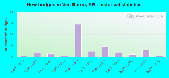
- New bridges - historical statistics
- 11920-1929
- 41930-1939
- 31940-1949
- 11950-1959
- 291960-1969
- 51970-1979
- 91980-1989
- 41990-1999
- 22000-2009
- 62010-2019
- 12020-2022

- Reconstructed bridges - Historical Statistics
- 71980-1989
- 21990-1999
- 42000-2009
- 22010-2019


- Bridge Condition - Deck
- 19.5%Very good
- 39.0%Good
- 24.4%Satisfactory
- 4.9%Fair
- 9.8%Poor
- 2.4%Serious

- Bridge Condition - Superstructure
- 14.6%Very good
- 56.1%Good
- 19.5%Satisfactory
- 7.3%Fair
- 2.4%Poor

- Bridge Condition - Substructure
- 9.8%Very good
- 17.1%Good
- 43.9%Satisfactory
- 26.8%Fair
- 2.4%Poor

- Bridge Condition - Channel
- 51.0%Very good
- 16.3%Good
- 20.4%Satisfactory
- 12.2%Fair

- Bridge Condition - Culverts
- 4.2%Excellent
- 25.0%Good
- 66.7%Satisfactory
- 4.2%Fair
Find on map >> Show street view
Structure Number: A3451, Location: 1.72 MI E INT 59 & I 40 (Lat: 35.457592, Lng: -94.327400), Route carried "on" structure: Interstate 40, Year Built: 1965, Year Reconstructed: 1986, Status: Open, Structure Length: 9.02m (29.59ft), Average Daily Traffic: 15,500 (year 2018), Truck Traffic: 1%, Average Future Daily Traffic: 21,339 (year 2028), Design Load: HS 20+Mod, Features Intersected: Rudy Rd,SLSFRR, Pointer
Minimum Vertical Clearance: 30+ m (98+ ft), Kilometerpoint: 11.232, Lanes on structure: 2, Lanes under structure: 4, Base Highway Network: Yes, Owner: State Highway Agency, Approaching Roadway Width: 12.2m (40.0ft), Material/Design: Steel, Design/Construction: Stringer/Multi-beam, Number Of Spans In Main Unit: 5, Length of Maximum Span: 18.6m (61.0ft), Curb-To-Curb Width: 12.2m (40.0ft), Out-to-Out Width: 13.0m (42.7ft)
Condition: Deck: Satisfactory, Superstructure: Good, Substructure: Satisfactory, Operating Rating: 54.4 metric tons, Method Used To Determine Operating Rating: Load Factor (LF), Inventory Rating: 32.7 metric tons, Method Used To Determine Inventory Rating: Load Factor (LF), Structural Evaluation: Equal to present minimum criteria, Deck Geometry: Better than present minimum criteria, Underclear: High priority of corrective action, Approach Roadway Alignment: Equal to present desirable criteria, Length Of Structure Improvement: 9.02m (29.59ft), Designated Inspection Frequency: Every 24 months, Critical Feature Inspection Frequency: Every 24 months, Inspection Date: Febuary 2022, Total Project Cost: $569,000, Deck Structure Type: Concrete Cast-file-Place, Wearing Surface/Protective System: Wearing Surface: Epoxy Overlay
Find on map >> Show street view
Structure Number: A3454, Location: 2.27 MI E INT 59 & I-40 (Lat: 35.455631, Lng: -94.318300), Route carried "on" structure: Interstate 40, Year Built: 1965, Year Reconstructed: 2019, Status: Open, Structure Length: 4.18m (13.71ft), Average Daily Traffic: 19,000 (year 2018), Truck Traffic: 35%, Average Future Daily Traffic: 24,573 (year 2028), Design Load: HS 20+Mod, Features Intersected: Flat Rock Creek-Crawford
Minimum Vertical Clearance: 30+ m (98+ ft), Kilometerpoint: 12.117, Lanes on structure: 3, Base Highway Network: Yes, Owner: State Highway Agency, Approaching Roadway Width: 15.5m (50.9ft), Material/Design: Steel, Design/Construction: Stringer/Multi-beam, Number Of Spans In Main Unit: 3, Length of Maximum Span: 13.7m (44.9ft), Curb-To-Curb Width: 15.5m (50.9ft), Out-to-Out Width: 17.6m (57.7ft)
Condition: Deck: Good, Superstructure: Good, Substructure: Satisfactory, Channel: Satisfactory, Operating Rating: 54.4 metric tons, Method Used To Determine Operating Rating: Load Factor (LF), Inventory Rating: 32.7 metric tons, Method Used To Determine Inventory Rating: Load Factor (LF), Structural Evaluation: Equal to present minimum criteria, Deck Geometry: Somewhat better than minimum adequacy, Waterway Adequacy: Equal to present desirable criteria, Approach Roadway Alignment: Equal to present desirable criteria, Length Of Structure Improvement: 4.18m (13.71ft), Designated Inspection Frequency: Every 24 months, Critical Feature Inspection Frequency: Every 24 months, Inspection Date: December 2021, Total Project Cost: $355,000, Deck Structure Type: Concrete Cast-file-Place, Wearing Surface/Protective System: Wearing Surface: Latex Concrete
Find on map >> Show street view
Structure Number: A3956, Location: 1.37 MI N SEB CO. LINE (Lat: 35.432561, Lng: -94.327911), Route carried "on" structure: Interstate 540, Year Built: 1968, Status: Open, Structure Length: 3.72m (12.20ft), Average Daily Traffic: 26,000 (year 2018), Truck Traffic: 1%, Average Future Daily Traffic: 28,453 (year 2028), Design Load: HS 20+Mod, Features Intersected: Flat Rock Creek-Crawford
Minimum Vertical Clearance: 30+ m (98+ ft), Kilometerpoint: 20.761, Lanes on structure: 2, Base Highway Network: Yes, Owner: State Highway Agency, Approaching Roadway Width: 11.6m (38.1ft), Material/Design: Steel, Design/Construction: Stringer/Multi-beam, Number Of Spans In Main Unit: 3, Length of Maximum Span: 12.2m (40.0ft), Curb or Sidewalk Widths: Left: 0.2m (0.7ft), Right: 0.2m (0.7ft), Curb-To-Curb Width: 11.9m (39.0ft), Out-to-Out Width: 12.9m (42.3ft)
Condition: Deck: Good, Superstructure: Good, Substructure: Fair, Channel: Very good, Operating Rating: 54.4 metric tons, Method Used To Determine Operating Rating: Load Factor (LF), Inventory Rating: 32.7 metric tons, Method Used To Determine Inventory Rating: Load Factor (LF), Structural Evaluation: Somewhat better than minimum adequacy, Deck Geometry: Equal to present minimum criteria, Waterway Adequacy: Equal to present desirable criteria, Approach Roadway Alignment: Equal to present desirable criteria, Designated Inspection Frequency: Every 24 months, Critical Feature Inspection Frequency: Every 24 months, Inspection Date: October 2021, Deck Structure Type: Concrete Cast-file-Place, Wearing Surface/Protective System: Wearing Surface: Monolithic Concrete
Find on map >> Show street view
Structure Number: A3957, Location: JCT I-540 & SH 162 (Lat: 35.436000, Lng: -94.320778), Route carried "on" structure: Interstate 540, Year Built: 1968, Year Reconstructed: 2013, Status: Open, Structure Length: 5.00m (16.40ft), Average Daily Traffic: 11,000 (year 2018), Truck Traffic: 12%, Average Future Daily Traffic: 28,000 (year 2032), Design Load: HS 20+Mod, Features Intersected: State Highway 162
Minimum Vertical Clearance: 30+ m (98+ ft), Kilometerpoint: 21.581, Lanes on structure: 2, Lanes under structure: 2, Base Highway Network: Yes, Owner: State Highway Agency, Approaching Roadway Width: 11.6m (38.1ft), Skew: 2 degrees, Material/Design: Steel, Design/Construction: Stringer/Multi-beam, Number Of Spans In Main Unit: 3, Length of Maximum Span: 16.5m (54.1ft), Curb-To-Curb Width: 12.4m (40.7ft), Out-to-Out Width: 13.2m (43.3ft)
Condition: Deck: Very good, Superstructure: Good, Substructure: Satisfactory, Operating Rating: 54.4 metric tons, Method Used To Determine Operating Rating: Load Factor (LF), Inventory Rating: 32.7 metric tons, Method Used To Determine Inventory Rating: Load Factor (LF), Structural Evaluation: Equal to present minimum criteria, Deck Geometry: Better than present minimum criteria, Underclear: Somewhat better than minimum adequacy, Approach Roadway Alignment: Equal to present desirable criteria, Designated Inspection Frequency: Every 24 months, Critical Feature Inspection Frequency: Every 24 months, Inspection Date: March 2020, Deck Structure Type: Concrete Cast-file-Place, Wearing Surface/Protective System: Wearing Surface: Monolithic Concrete, Deck Protection: Epoxy Coated Reinforcing
Find on map >> Show street view
Structure Number: A3959, Location: JCT. HWY 64,71 & 540 (Lat: 35.447119, Lng: -94.320631), Route carried "on" structure: US 64, Year Built: 1967, Status: Open, Structure Length: 10.64m (34.91ft), Average Daily Traffic: 5,440 (year 2018), Truck Traffic: 1%, Average Future Daily Traffic: 12,933 (year 2028), Design Load: HS 20, Features Intersected: I 540-SEC 2-Crawford Co.
Minimum Vertical Clearance: 30+ m (98+ ft), Kilometerpoint: 3.701, Lanes on structure: 3, Lanes under structure: 6, Base Highway Network: Yes, Owner: State Highway Agency, Approaching Roadway Width: 15.2m (49.9ft), Skew: 3 degrees, Material/Design: Steel, Design/Construction: Stringer/Multi-beam, Number Of Spans In Main Unit: 5, Length of Maximum Span: 24.4m (80.1ft), Curb or Sidewalk Widths: Left: 0.5m (1.6ft), Right: 0.5m (1.6ft), Curb-To-Curb Width: 12.2m (40.0ft), Out-to-Out Width: 13.9m (45.6ft)
Condition: Deck: Poor, Superstructure: Satisfactory, Substructure: Fair, Operating Rating: 54.4 metric tons, Method Used To Determine Operating Rating: Load Factor (LF), Inventory Rating: 32.7 metric tons, Method Used To Determine Inventory Rating: Load Factor (LF), Structural Evaluation: Somewhat better than minimum adequacy, Deck Geometry: Meets minimum limits, Underclear: High priority of corrective action, Approach Roadway Alignment: Equal to present desirable criteria, Length Of Structure Improvement: 10.64m (34.91ft), Designated Inspection Frequency: Every 24 months, Critical Feature Inspection Frequency: Every 24 months, Other Special Inspection Frequency: Every 24 months, Inspection Date: November 2021, Other Special Inspection Date: September 2020, Total Project Cost: $165,000, Deck Structure Type: Concrete Cast-file-Place, Wearing Surface/Protective System: Wearing Surface: Monolithic Concrete
Find on map >> Show street view
Structure Number: A3961, Location: 0.05 MI N US 64 (Lat: 35.449689, Lng: -94.316181), Route carried "on" structure: County highway 954, Year Built: 1966, Status: Open, Structure Length: 2.83m (9.28ft), Average Daily Traffic: 35 (year 1984), Truck Traffic: 1%, Average Future Daily Traffic: 45 (year 2004), Design Load: H 15, Features Intersected: Flat Rock Ck-Crawford Co
Minimum Vertical Clearance: 30+ m (98+ ft), Kilometerpoint: 0.080, Lanes on structure: 2, Owner: State Highway Agency, Approaching Roadway Width: 6.1m (20.0ft), Material/Design: Concrete, Design/Construction: Channel Beam, Number Of Spans In Main Unit: 3, Length of Maximum Span: 9.4m (30.8ft), Curb or Sidewalk Widths: Left: 0.3m (1.0ft), Right: 0.3m (1.0ft), Curb-To-Curb Width: 5.8m (19.0ft), Out-to-Out Width: 6.4m (21.0ft)
Condition: Deck: Good, Superstructure: Good, Substructure: Fair, Channel: Good, Operating Rating: 54.4 metric tons, Method Used To Determine Operating Rating: Load Factor (LF), Inventory Rating: 32.7 metric tons, Method Used To Determine Inventory Rating: Load Factor (LF), Structural Evaluation: Somewhat better than minimum adequacy, Deck Geometry: Meets minimum limits, Waterway Adequacy: Equal to present desirable criteria, Approach Roadway Alignment: Equal to present desirable criteria, Designated Inspection Frequency: Every 24 months, Critical Feature Inspection Frequency: Every 24 months, Inspection Date: September 2021, Deck Structure Type: Concrete Precast Panels, Wearing Surface/Protective System: Wearing Surface: Monolithic Concrete
Find on map >> Show street view
Structure Number: A6881, Location: 0.99 Mi South of I-40 (Lat: 35.439700, Lng: -94.319689), Route carried "on" structure: Interstate 540, Year Built: 2014, Status: Open, Structure Length: 14.78m (48.49ft), Average Daily Traffic: 8,000 (year 2018), Truck Traffic: 12%, Average Future Daily Traffic: 36,790 (year 2032), Design Load: HS 20+Mod, Features Intersected: Union Pacific Rail Road
Minimum Vertical Clearance: 30+ m (98+ ft), Kilometerpoint: 22.048, Lanes on structure: 2, Base Highway Network: Yes, Owner: State Highway Agency, Approaching Roadway Width: 12.2m (40.0ft), Skew: 3 degrees, Material/Design: Steel continuous, Design/Construction: Stringer/Multi-beam, Number Of Spans In Main Unit: 5, Length of Maximum Span: 30.5m (100.1ft), Curb-To-Curb Width: 12.2m (40.0ft), Out-to-Out Width: 13.1m (43.0ft)
Condition: Deck: Very good, Superstructure: Very good, Substructure: Very good, Channel: Very good, Operating Rating: 54.4 metric tons, Method Used To Determine Operating Rating: Load Factor (LF), Inventory Rating: 32.7 metric tons, Method Used To Determine Inventory Rating: Load Factor (LF), Structural Evaluation: Equal to present desirable criteria, Deck Geometry: Better than present minimum criteria, Underclear: Superior to present desirable criteria, Waterway Adequacy: Equal to present desirable criteria, Approach Roadway Alignment: Equal to present desirable criteria, Designated Inspection Frequency: Every 24 months, Critical Feature Inspection Frequency: Every 24 months, Inspection Date: March 2020, Deck Structure Type: Concrete Cast-file-Place, Wearing Surface/Protective System: Wearing Surface: Monolithic Concrete, Deck Protection: Epoxy Coated Reinforcing
Find on map >> Show street view
Structure Number: B3272, Location: 3.56 MI E OKLAHOMA ST LIN (Lat: 35.462650, Lng: -94.385511), Route carried "on" structure: Interstate 40, Year Built: 1965, Year Reconstructed: 1987, Status: Open, Structure Length: 14.11m (46.29ft), Average Daily Traffic: 10,000 (year 2018), Truck Traffic: 1%, Average Future Daily Traffic: 12,286 (year 2028), Design Load: HS 20+Mod, Features Intersected: Lee Creek-Crawford Co.
Minimum Vertical Clearance: 30+ m (98+ ft), Kilometerpoint: 5.728, Lanes on structure: 2, Base Highway Network: Yes, Owner: State Highway Agency, Approaching Roadway Width: 12.2m (40.0ft), Skew: 3 degrees, Material/Design: Steel, Design/Construction: Stringer/Multi-beam, Number Of Spans In Main Unit: 7, Length of Maximum Span: 21.3m (69.9ft), Curb-To-Curb Width: 12.2m (40.0ft), Out-to-Out Width: 13.0m (42.7ft)
Condition: Deck: Good, Superstructure: Good, Substructure: Satisfactory, Channel: Satisfactory, Operating Rating: 54.4 metric tons, Method Used To Determine Operating Rating: Load Factor (LF), Inventory Rating: 32.7 metric tons, Method Used To Determine Inventory Rating: Load Factor (LF), Structural Evaluation: Equal to present minimum criteria, Deck Geometry: Better than present minimum criteria, Waterway Adequacy: Equal to present desirable criteria, Approach Roadway Alignment: Equal to present desirable criteria, Designated Inspection Frequency: Every 24 months, Critical Feature Inspection Frequency: Every 24 months, Inspection Date: March 2020, Deck Structure Type: Concrete Cast-file-Place, Wearing Surface/Protective System: Wearing Surface: Epoxy Overlay
Find on map >> Show street view
Structure Number: B3273, Location: JCT I 40 & SH 59 (Lat: 35.462594, Lng: -94.356964), Route carried "on" structure: Interstate 40, Year Built: 1965, Year Reconstructed: 1987, Status: Open, Structure Length: 6.77m (22.21ft), Average Daily Traffic: 10,085 (year 2018), Truck Traffic: 1%, Average Future Daily Traffic: 21,339 (year 2028), Design Load: HS 20+Mod, Features Intersected: SH 59-SEC 5-Crawford Co.
Minimum Vertical Clearance: 30+ m (98+ ft), Kilometerpoint: 8.464, Lanes on structure: 2, Lanes under structure: 5, Base Highway Network: Yes, Owner: State Highway Agency, Approaching Roadway Width: 12.2m (40.0ft), Material/Design: Steel, Design/Construction: Stringer/Multi-beam, Number Of Spans In Main Unit: 4, Length of Maximum Span: 22.9m (75.1ft), Curb-To-Curb Width: 12.2m (40.0ft), Out-to-Out Width: 13.0m (42.7ft)
Condition: Deck: Good, Superstructure: Good, Substructure: Satisfactory, Operating Rating: 54.4 metric tons, Method Used To Determine Operating Rating: Load Factor (LF), Inventory Rating: 32.7 metric tons, Method Used To Determine Inventory Rating: Load Factor (LF), Structural Evaluation: Equal to present minimum criteria, Deck Geometry: Better than present minimum criteria, Underclear: Meets minimum limits, Approach Roadway Alignment: Equal to present desirable criteria, Designated Inspection Frequency: Every 24 months, Critical Feature Inspection Frequency: Every 24 months, Inspection Date: Febuary 2022, Deck Structure Type: Concrete Cast-file-Place, Wearing Surface/Protective System: Wearing Surface: Epoxy Overlay
Find on map >> Show street view
Structure Number: B3451, Location: 1.72 MI E JCT SH 59 (Lat: 35.457353, Lng: -94.327483), Route carried "on" structure: Interstate 40, Year Built: 1965, Year Reconstructed: 1987, Status: Open, Structure Length: 9.02m (29.59ft), Average Daily Traffic: 15,500 (year 2018), Truck Traffic: 21%, Average Future Daily Traffic: 21,339 (year 2028), Design Load: HS 20+Mod, Features Intersected: Rudy Rd, SLSF RR,Pointer
Minimum Vertical Clearance: 30+ m (98+ ft), Kilometerpoint: 11.232, Lanes on structure: 2, Lanes under structure: 4, Base Highway Network: Yes, Owner: State Highway Agency, Approaching Roadway Width: 12.2m (40.0ft), Material/Design: Steel, Design/Construction: Stringer/Multi-beam, Number Of Spans In Main Unit: 5, Length of Maximum Span: 18.6m (61.0ft), Curb-To-Curb Width: 12.2m (40.0ft), Out-to-Out Width: 13.0m (42.7ft)
Condition: Deck: Satisfactory, Superstructure: Good, Substructure: Satisfactory, Operating Rating: 54.4 metric tons, Method Used To Determine Operating Rating: Load Factor (LF), Inventory Rating: 32.7 metric tons, Method Used To Determine Inventory Rating: Load Factor (LF), Structural Evaluation: Equal to present minimum criteria, Deck Geometry: Better than present minimum criteria, Underclear: Meets minimum limits, Approach Roadway Alignment: Equal to present desirable criteria, Designated Inspection Frequency: Every 24 months, Critical Feature Inspection Frequency: Every 24 months, Inspection Date: Febuary 2022, Deck Structure Type: Concrete Cast-file-Place, Wearing Surface/Protective System: Wearing Surface: Epoxy Overlay
Find on map >> Show street view
Structure Number: B3454, Location: 0.13 MI E JCT I-540 (Lat: 35.455369, Lng: -94.318289), Route carried "on" structure: Interstate 40, Year Built: 1965, Year Reconstructed: 2019, Status: Open, Structure Length: 4.18m (13.71ft), Average Daily Traffic: 19,000 (year 2018), Truck Traffic: 21%, Average Future Daily Traffic: 24,573 (year 2028), Design Load: HS 20+Mod, Features Intersected: Flat Rock Creek
Minimum Vertical Clearance: 30+ m (98+ ft), Kilometerpoint: 12.117, Lanes on structure: 3, Base Highway Network: Yes, Owner: State Highway Agency, Approaching Roadway Width: 18.3m (60.0ft), Material/Design: Steel, Design/Construction: Stringer/Multi-beam, Number Of Spans In Main Unit: 3, Length of Maximum Span: 13.7m (44.9ft), Curb-To-Curb Width: 15.5m (50.9ft), Out-to-Out Width: 17.6m (57.7ft)
Condition: Deck: Good, Superstructure: Good, Substructure: Fair, Channel: Good, Operating Rating: 54.4 metric tons, Method Used To Determine Operating Rating: Load Factor (LF), Inventory Rating: 32.7 metric tons, Method Used To Determine Inventory Rating: Load Factor (LF), Structural Evaluation: Somewhat better than minimum adequacy, Deck Geometry: Somewhat better than minimum adequacy, Waterway Adequacy: Equal to present desirable criteria, Approach Roadway Alignment: Equal to present desirable criteria, Designated Inspection Frequency: Every 24 months, Critical Feature Inspection Frequency: Every 24 months, Inspection Date: December 2021, Deck Structure Type: Concrete Cast-file-Place, Wearing Surface/Protective System: Wearing Surface: Latex Concrete
Find on map >> Show street view
Structure Number: B3956, Location: 1.37 MI N SEBASTIAN CO LN (Lat: 35.432250, Lng: -94.327719), Route carried "on" structure: Interstate 540, Year Built: 1968, Status: Open, Structure Length: 3.72m (12.20ft), Average Daily Traffic: 26,000 (year 2016), Truck Traffic: 11%, Average Future Daily Traffic: 28,453 (year 2028), Design Load: HS 20+Mod, Features Intersected: Flat Rock Cr. -Craw. Co
Minimum Vertical Clearance: 30+ m (98+ ft), Kilometerpoint: 20.761, Lanes on structure: 2, Base Highway Network: Yes, Owner: State Highway Agency, Approaching Roadway Width: 11.6m (38.1ft), Material/Design: Steel, Design/Construction: Stringer/Multi-beam, Number Of Spans In Main Unit: 3, Length of Maximum Span: 12.2m (40.0ft), Curb or Sidewalk Widths: Left: 0.2m (0.7ft), Right: 0.2m (0.7ft), Curb-To-Curb Width: 11.9m (39.0ft), Out-to-Out Width: 12.9m (42.3ft)
Condition: Deck: Good, Superstructure: Good, Substructure: Fair, Channel: Very good, Operating Rating: 54.4 metric tons, Method Used To Determine Operating Rating: Load Factor (LF), Inventory Rating: 32.7 metric tons, Method Used To Determine Inventory Rating: Load Factor (LF), Structural Evaluation: Somewhat better than minimum adequacy, Deck Geometry: Equal to present minimum criteria, Waterway Adequacy: Equal to present desirable criteria, Approach Roadway Alignment: Equal to present desirable criteria, Designated Inspection Frequency: Every 24 months, Critical Feature Inspection Frequency: Every 24 months, Inspection Date: October 2021, Deck Structure Type: Concrete Cast-file-Place, Wearing Surface/Protective System: Wearing Surface: Monolithic Concrete
Find on map >> Show street view
Structure Number: B3957, Location: 1.98 MI N SEBASTIAN CO LN (Lat: 35.435986, Lng: -94.320147), Route carried "on" structure: Interstate 540, Year Built: 1968, Year Reconstructed: 2013, Status: Open, Structure Length: 5.00m (16.40ft), Average Daily Traffic: 11,000 (year 2018), Truck Traffic: 11%, Average Future Daily Traffic: 28,000 (year 2032), Design Load: HS 20+Mod, Features Intersected: State Highway 162
Minimum Vertical Clearance: 30+ m (98+ ft), Kilometerpoint: 21.581, Lanes on structure: 2, Lanes under structure: 2, Base Highway Network: Yes, Owner: State Highway Agency, Approaching Roadway Width: 11.6m (38.1ft), Skew: 2 degrees, Material/Design: Steel, Design/Construction: Stringer/Multi-beam, Number Of Spans In Main Unit: 3, Length of Maximum Span: 16.5m (54.1ft), Curb-To-Curb Width: 12.2m (40.0ft), Out-to-Out Width: 13.1m (43.0ft)
Condition: Deck: Very good, Superstructure: Good, Substructure: Satisfactory, Operating Rating: 54.4 metric tons, Method Used To Determine Operating Rating: Load Factor (LF), Inventory Rating: 32.7 metric tons, Method Used To Determine Inventory Rating: Load Factor (LF), Structural Evaluation: Equal to present minimum criteria, Deck Geometry: Better than present minimum criteria, Underclear: Somewhat better than minimum adequacy, Approach Roadway Alignment: Equal to present desirable criteria, Designated Inspection Frequency: Every 24 months, Critical Feature Inspection Frequency: Every 24 months, Inspection Date: March 2020, Deck Structure Type: Concrete Cast-file-Place, Wearing Surface/Protective System: Wearing Surface: Epoxy Overlay, Deck Protection: Epoxy Coated Reinforcing
Find on map >> Show street view
Structure Number: B3959, Location: JCT. HWY 64,71 & I540 (Lat: 35.446881, Lng: -94.320600), Route carried "on" structure: US 64, Year Built: 1967, Status: Open, Structure Length: 10.64m (34.91ft), Average Daily Traffic: 5,440 (year 2018), Truck Traffic: 1%, Average Future Daily Traffic: 12,933 (year 2028), Design Load: HS 20, Features Intersected: Interstate 540-Crawford
Minimum Vertical Clearance: 30+ m (98+ ft), Kilometerpoint: 3.718, Lanes on structure: 3, Lanes under structure: 6, Base Highway Network: Yes, Owner: State Highway Agency, Approaching Roadway Width: 15.2m (49.9ft), Skew: 3 degrees, Material/Design: Steel, Design/Construction: Stringer/Multi-beam, Number Of Spans In Main Unit: 5, Length of Maximum Span: 24.4m (80.1ft), Curb or Sidewalk Widths: Left: 0.5m (1.6ft), Right: 0.5m (1.6ft), Curb-To-Curb Width: 12.2m (40.0ft), Out-to-Out Width: 13.9m (45.6ft)
Condition: Deck: Serious, Superstructure: Good, Substructure: Fair, Operating Rating: 54.4 metric tons, Method Used To Determine Operating Rating: Load Factor (LF), Inventory Rating: 32.7 metric tons, Method Used To Determine Inventory Rating: Load Factor (LF), Structural Evaluation: Somewhat better than minimum adequacy, Deck Geometry: Meets minimum limits, Underclear: High priority of corrective action, Approach Roadway Alignment: Equal to present desirable criteria, Length Of Structure Improvement: 10.64m (34.91ft), Designated Inspection Frequency: Every 24 months, Critical Feature Inspection Frequency: Every 24 months, Other Special Inspection Frequency: Every 24 months, Inspection Date: November 2021, Other Special Inspection Date: September 2020, Total Project Cost: $165,000, Deck Structure Type: Concrete Cast-file-Place, Wearing Surface/Protective System: Wearing Surface: Monolithic Concrete
Find on map >> Show street view
Structure Number: B6881, Location: 0.98 Mi S0. of I-40 (Lat: 35.439928, Lng: -94.319297), Route carried "on" structure: Interstate 540, Year Built: 2014, Status: Open, Structure Length: 14.78m (48.49ft), Average Daily Traffic: 8,000 (year 2018), Truck Traffic: 11%, Average Future Daily Traffic: 23,790 (year 2032), Design Load: HS 20+Mod, Features Intersected: Union Pacific Rail Road
Minimum Vertical Clearance: 30+ m (98+ ft), Kilometerpoint: 22.048, Lanes on structure: 2, Base Highway Network: Yes, Owner: State Highway Agency, Approaching Roadway Width: 11.7m (38.4ft), Skew: 3 degrees, Material/Design: Steel continuous, Design/Construction: Stringer/Multi-beam, Number Of Spans In Main Unit: 5, Length of Maximum Span: 30.5m (100.1ft), Curb-To-Curb Width: 12.2m (40.0ft), Out-to-Out Width: 13.1m (43.0ft)
Condition: Deck: Very good, Superstructure: Very good, Substructure: Very good, Channel: Very good, Operating Rating: 54.4 metric tons, Method Used To Determine Operating Rating: Load Factor (LF), Inventory Rating: 32.7 metric tons, Method Used To Determine Inventory Rating: Load Factor (LF), Structural Evaluation: Equal to present desirable criteria, Deck Geometry: Better than present minimum criteria, Underclear: Superior to present desirable criteria, Waterway Adequacy: Equal to present desirable criteria, Approach Roadway Alignment: Equal to present desirable criteria, Designated Inspection Frequency: Every 24 months, Critical Feature Inspection Frequency: Every 24 months, Inspection Date: March 2020, Deck Structure Type: Concrete Cast-file-Place, Wearing Surface/Protective System: Wearing Surface: Epoxy Overlay, Deck Protection: Epoxy Coated Reinforcing
Find on map >> Show street view
Structure Number: M1065, Location: 0.3 MI NORTH OF I-40 (Lat: 35.467494, Lng: -94.356358), Route carried "on" structure: State highway 59, Year Built: 1947, Year Reconstructed: 1998, Status: Open, Structure Length: 0.64m (2.10ft), Average Daily Traffic: 23,000 (year 2018), Truck Traffic: 5%, Average Future Daily Traffic: 28,453 (year 2028), Features Intersected: Creek-Crawford Co.
Minimum Vertical Clearance: 30+ m (98+ ft), Kilometerpoint: 39.920, Lanes on structure: 5, Base Highway Network: Yes, Owner: State Highway Agency, Approaching Roadway Width: 17.4m (57.1ft), Material/Design: Concrete, Design/Construction: Culvert, Number Of Spans In Main Unit: 2, Length of Maximum Span: 3.4m (11.2ft)
Condition: Channel: Good, Culverts: Satisfactory, Operating Rating: 29.0 metric tons, Method Used To Determine Operating Rating: Load Factor (LF), Inventory Rating: 17.2 metric tons, Method Used To Determine Inventory Rating: Load Factor (LF), Structural Evaluation: Meets minimum limits, Waterway Adequacy: Equal to present desirable criteria, Approach Roadway Alignment: Better than present minimum criteria, Designated Inspection Frequency: Every 24 months, Critical Feature Inspection Frequency: Every 24 months, Inspection Date: March 2021
Find on map >> Show street view
Structure Number: M1066, Location: 0.06 M S OF I-40 (Lat: 35.461197, Lng: -94.356539), Route carried "on" structure: State highway 59, Year Built: 1947, Year Reconstructed: 1998, Status: Open, Structure Length: 0.73m (2.40ft), Average Daily Traffic: 22,208 (year 2018), Truck Traffic: 5%, Average Future Daily Traffic: 33,626 (year 2028), Features Intersected: Creek-Crawford Co.
Minimum Vertical Clearance: 30+ m (98+ ft), Kilometerpoint: 40.610, Lanes on structure: 5, Base Highway Network: Yes, Owner: State Highway Agency, Approaching Roadway Width: 17.4m (57.1ft), Skew: 3 degrees, Material/Design: Concrete, Design/Construction: Culvert, Number Of Spans In Main Unit: 2, Length of Maximum Span: 3.7m (12.1ft)
Condition: Channel: Very good, Culverts: Satisfactory, Operating Rating: 31.8 metric tons, Method Used To Determine Operating Rating: Load Factor (LF), Inventory Rating: 19.1 metric tons, Method Used To Determine Inventory Rating: Load Factor (LF), Structural Evaluation: Meets minimum limits, Waterway Adequacy: Meets minimum limits, Approach Roadway Alignment: Equal to present desirable criteria, Designated Inspection Frequency: Every 24 months, Critical Feature Inspection Frequency: Every 24 months, Inspection Date: March 2021
Find on map >> Show street view
Structure Number: X0061, Location: 0.1 MI SE JCT I-540 & 59 (Lat: 35.424931, Lng: -94.340739), Route carried "on" structure: Ramp Interstate 540, Year Built: 1968, Status: Open, Structure Length: 0.98m (3.22ft), Average Daily Traffic: 10,253 (year 2011), Truck Traffic: 1%, Average Future Daily Traffic: 2,750 (year 2032), Features Intersected: Town Ditch-Crawford Co.
Minimum Vertical Clearance: 30+ m (98+ ft), Kilometerpoint: 19.179, Lanes on structure: 2, Owner: State Highway Agency, Approaching Roadway Width: 14.0m (45.9ft), Skew: 1 degrees, Material/Design: Concrete, Design/Construction: Culvert, Number Of Spans In Main Unit: 3, Length of Maximum Span: 3.4m (11.2ft)
Condition: Channel: Very good, Culverts: Satisfactory, Operating Rating: 28.1 metric tons, Method Used To Determine Operating Rating: Load Factor (LF), Inventory Rating: 17.2 metric tons, Method Used To Determine Inventory Rating: Load Factor (LF), Structural Evaluation: Meets minimum limits, Waterway Adequacy: Equal to present desirable criteria, Approach Roadway Alignment: Equal to present desirable criteria, Designated Inspection Frequency: Every 24 months, Critical Feature Inspection Frequency: Every 24 months, Inspection Date: August 2021
Find on map >> Show street view
Structure Number: X0062, Location: 0.1 Mi NE Jct I540 & 59 (Lat: 35.426528, Lng: -94.343556), Route carried "on" structure: Ramp Interstate 540, Year Built: 1968, Status: Open, Structure Length: 0.98m (3.22ft), Average Daily Traffic: 6,400 (year 2018), Truck Traffic: 1%, Average Future Daily Traffic: 2,750 (year 2028), Features Intersected: Town Ditch-Crawford Co.
Minimum Vertical Clearance: 30+ m (98+ ft), Kilometerpoint: 19.179, Lanes on structure: 2, Owner: State Highway Agency, Approaching Roadway Width: 14.0m (45.9ft), Skew: 1 degrees, Material/Design: Concrete, Design/Construction: Culvert, Number Of Spans In Main Unit: 3, Length of Maximum Span: 3.4m (11.2ft)
Condition: Channel: Very good, Culverts: Satisfactory, Operating Rating: 28.1 metric tons, Method Used To Determine Operating Rating: Load Factor (LF), Inventory Rating: 17.2 metric tons, Method Used To Determine Inventory Rating: Load Factor (LF), Structural Evaluation: Meets minimum limits, Waterway Adequacy: Equal to present desirable criteria, Approach Roadway Alignment: Equal to present desirable criteria, Designated Inspection Frequency: Every 24 months, Critical Feature Inspection Frequency: Every 24 months, Inspection Date: July 2021
Find on map >> Show street view
Structure Number: X0064, Location: 0.1 Mi N. I540 & 59 (Lat: 35.426028, Lng: -94.342750), Route carried "on" structure: Interstate 540, Year Built: 1966, Status: Open, Structure Length: 0.98m (3.22ft), Average Daily Traffic: 51,984 (year 2016), Truck Traffic: 1%, Average Future Daily Traffic: 67,252 (year 2028), Design Load: H 20, Features Intersected: Town Ditch-Crawford Co.
Minimum Vertical Clearance: 30+ m (98+ ft), Kilometerpoint: 19.179, Lanes on structure: 4, Base Highway Network: Yes, Owner: State Highway Agency, Approaching Roadway Width: 23.8m (78.1ft), Skew: 31 degrees, Material/Design: Concrete, Design/Construction: Culvert, Number Of Spans In Main Unit: 3, Length of Maximum Span: 3.4m (11.2ft)
Condition: Channel: Very good, Culverts: Fair, Operating Rating: 39.0 metric tons, Method Used To Determine Operating Rating: Load Factor (LF), Inventory Rating: 23.6 metric tons, Method Used To Determine Inventory Rating: Load Factor (LF), Structural Evaluation: Somewhat better than minimum adequacy, Waterway Adequacy: Equal to present desirable criteria, Approach Roadway Alignment: Equal to present desirable criteria, Designated Inspection Frequency: Every 24 months, Critical Feature Inspection Frequency: Every 24 months, Inspection Date: August 2021
Find on map >> Show street view
Structure Number: X0211, Location: 5.2 MI E OKLA ST LN (Lat: 35.463611, Lng: -94.356800), Route carried "on" structure: Ramp Interstate 40, Year Built: 1965, Status: Open, Structure Length: 0.76m (2.49ft), Average Daily Traffic: 3,733 (year 2011), Truck Traffic: 1%, Average Future Daily Traffic: 5,500 (year 2028), Design Load: H 20, Features Intersected: Creek-Crawford Co.
Minimum Vertical Clearance: 30+ m (98+ ft), Kilometerpoint: 8.447, Lanes on structure: 1, Owner: State Highway Agency, Approaching Roadway Width: 7.6m (24.9ft), Material/Design: Concrete, Design/Construction: Culvert, Number Of Spans In Main Unit: 2, Length of Maximum Span: 4.0m (13.1ft)
Condition: Channel: Fair, Culverts: Satisfactory, Operating Rating: 31.8 metric tons, Method Used To Determine Operating Rating: Load Factor (LF), Inventory Rating: 19.1 metric tons, Method Used To Determine Inventory Rating: Load Factor (LF), Structural Evaluation: Meets minimum limits, Waterway Adequacy: Equal to present minimum criteria, Approach Roadway Alignment: Equal to present desirable criteria, Designated Inspection Frequency: Every 24 months, Critical Feature Inspection Frequency: Every 24 months, Inspection Date: December 2021
Find on map >> Show street view
Structure Number: X0212, Location: 5.2 MI E OKLA ST LN (Lat: 35.462031, Lng: -94.356800), Route carried "on" structure: Ramp Interstate 40, Year Built: 1965, Status: Open, Structure Length: 0.82m (2.69ft), Average Daily Traffic: 15 (year 2008), Truck Traffic: 1%, Average Future Daily Traffic: 5,500 (year 2028), Design Load: H 20, Features Intersected: Creek-Crawford Co.
Minimum Vertical Clearance: 30+ m (98+ ft), Kilometerpoint: 8.447, Lanes on structure: 1, Owner: State Highway Agency, Approaching Roadway Width: 8.2m (26.9ft), Material/Design: Concrete, Design/Construction: Culvert, Number Of Spans In Main Unit: 2, Length of Maximum Span: 4.3m (14.1ft)
Condition: Channel: Fair, Culverts: Satisfactory, Operating Rating: 31.8 metric tons, Method Used To Determine Operating Rating: Load Factor (LF), Inventory Rating: 19.1 metric tons, Method Used To Determine Inventory Rating: Load Factor (LF), Structural Evaluation: Meets minimum limits, Waterway Adequacy: Somewhat better than minimum adequacy, Approach Roadway Alignment: Equal to present desirable criteria, Designated Inspection Frequency: Every 24 months, Critical Feature Inspection Frequency: Every 24 months, Inspection Date: March 2021
Find on map >> Show street view
Structure Number: X0388, Location: 0.5 MI SO JCT I-540 (Lat: 35.419908, Lng: -94.336589), Route carried "on" structure: State highway 59, Year Built: 1979, Status: Open, Structure Length: 1.68m (5.51ft), Average Daily Traffic: 6,365 (year 2018), Truck Traffic: 1%, Average Future Daily Traffic: 7,760 (year 2028), Features Intersected: Town Ditch
Minimum Vertical Clearance: 30+ m (98+ ft), Kilometerpoint: 2.446, Lanes on structure: 2, Owner: State Highway Agency, Approaching Roadway Width: 12.2m (40.0ft), Skew: 4 degrees, Material/Design: Concrete, Design/Construction: Culvert, Number Of Spans In Main Unit: 4, Length of Maximum Span: 4.3m (14.1ft)
Condition: Channel: Satisfactory, Culverts: Satisfactory, Operating Rating: 32.7 metric tons, Method Used To Determine Operating Rating: Load Factor (LF), Inventory Rating: 19.1 metric tons, Method Used To Determine Inventory Rating: Load Factor (LF), Structural Evaluation: Meets minimum limits, Waterway Adequacy: Equal to present desirable criteria, Approach Roadway Alignment: Equal to present desirable criteria, Designated Inspection Frequency: Every 24 months, Critical Feature Inspection Frequency: Every 24 months, Inspection Date: November 2021
Find on map >> Show street view
Structure Number: X0389, Location: 2.4 MI SO JCT I-540 (Lat: 35.394731, Lng: -94.330408), Route carried "on" structure: State highway 59, Year Built: 1979, Status: Open, Structure Length: 1.55m (5.09ft), Average Daily Traffic: 7,269 (year 2018), Truck Traffic: 1%, Average Future Daily Traffic: 6,337 (year 2028), Design Load: H 20, Features Intersected: Town Ditch
Minimum Vertical Clearance: 30+ m (98+ ft), Kilometerpoint: 5.456, Lanes on structure: 2, Owner: State Highway Agency, Approaching Roadway Width: 12.2m (40.0ft), Skew: 4 degrees, Material/Design: Concrete, Design/Construction: Culvert, Number Of Spans In Main Unit: 4, Length of Maximum Span: 4.0m (13.1ft)
Condition: Channel: Fair, Culverts: Satisfactory, Operating Rating: 34.5 metric tons, Method Used To Determine Operating Rating: Load Factor (LF), Inventory Rating: 20.9 metric tons, Method Used To Determine Inventory Rating: Load Factor (LF), Structural Evaluation: Somewhat better than minimum adequacy, Waterway Adequacy: Equal to present desirable criteria, Approach Roadway Alignment: Equal to present desirable criteria, Designated Inspection Frequency: Every 48 months, Critical Feature Inspection Frequency: Every 24 months, Inspection Date: December 2021
Find on map >> Show street view
Structure Number: X1624, Location: 0.1 Mi W Jct Hwy 64 & 162 (Lat: 35.436553, Lng: -94.339142), Route carried "on" structure: US 64, Year Built: 2021, Status: Open, Structure Length: 1.04m (3.41ft), Average Daily Traffic: 15,000 (year 2018), Truck Traffic: 1%, Average Future Daily Traffic: 25,866 (year 2028), Design Load: HL 93, Features Intersected: Town Branch
Minimum Vertical Clearance: 30+ m (98+ ft), Kilometerpoint: 1.529, Lanes on structure: 4, Owner: State Highway Agency, Approaching Roadway Width: 15.2m (49.9ft), Material/Design: Concrete, Design/Construction: Culvert, Number Of Spans In Main Unit: 3, Length of Maximum Span: 3.4m (11.2ft), Curb or Sidewalk Widths: Left: 2.7m (8.9ft), Right: 1.5m (4.9ft), Curb-To-Curb Width: 15.2m (49.9ft), Out-to-Out Width: 19.5m (64.0ft)
Condition: Channel: Very good, Culverts: Excellent, Operating Rating: 38.1 metric tons, Method Used To Determine Operating Rating: Load and Resistance Factor (LRFR), Inventory Rating: 29.9 metric tons, Method Used To Determine Inventory Rating: Load and Resistance Factor (LRFR), Structural Evaluation: Better than present minimum criteria, Deck Geometry: High priority of corrective action, Waterway Adequacy: Equal to present minimum criteria, Approach Roadway Alignment: Equal to present desirable criteria, Designated Inspection Frequency: Every 24 months, Critical Feature Inspection Frequency: Every 24 months, Inspection Date: August 2021
Find on map >> Show street view
Structure Number: 1802, Location: Van Buren (Lat: 35.431625, Lng: -94.356475), Route carried "under" structure: City street 64450, Structure Length: 0. m, Average Daily Traffic: 204 (year 1990), Truck Traffic: 1%, Features Intersected: 1st Street, Facility Carried by Structure: Jefferson St-Craw.
Minimum Vertical Clearance: 4.03m (13.22ft), Kilometerpoint: 0.274, Length of Maximum Span: 0.0m
Find on map >> Show street view
Structure Number: 1802, Location: Van Buren (Lat: 35.431625, Lng: -94.356475), Route carried "under" structure: City street 64470, Structure Length: 0. m, Average Daily Traffic: 500 (year 2008), Truck Traffic: 1%, Features Intersected: 3rd Street, Facility Carried by Structure: Jefferson St-Craw.
Minimum Vertical Clearance: 4.81m (15.78ft), Kilometerpoint: 0.097, Length of Maximum Span: 0.0m
Find on map >> Show street view
Structure Number: 345, Location: 6.12 MI E OKLAHOMA ST LN (Lat: 35.460800, Lng: -94.341931), Route carried "under" structure: Interstate 40, Structure Length: 0. m, Average Daily Traffic: 14,500 (year 2014), Truck Traffic: 1%, Features Intersected: I 40-SEC 11, Facility Carried by Structure: N 16th St.
Minimum Vertical Clearance: 5.05m (16.57ft), Kilometerpoint: 9.848, Length of Maximum Span: 0.0m
Find on map >> Show street view
Structure Number: 345, Location: 6.12 MI E OKLAHOMA ST LN (Lat: 35.460800, Lng: -94.341931), Route carried "under" structure: Interstate 40, Structure Length: 0. m, Average Daily Traffic: 14,500 (year 2014), Truck Traffic: 1%, Features Intersected: I 40-SEC 11, Facility Carried by Structure: N 16th St.
Minimum Vertical Clearance: 5.41m (17.75ft), Kilometerpoint: 9.848, Length of Maximum Span: 0.0m
Find on map >> Show street view
Structure Number: 3452, Location: @ INTERCH I 40 & I 540 (Lat: 35.455011, Lng: -94.321039), Route carried "under" structure: Interstate 40, Structure Length: 0. m, Average Daily Traffic: 17,000 (year 2014), Truck Traffic: 1%, Features Intersected: I 40-SEC 11
Minimum Vertical Clearance: 5.27m (17.29ft), Kilometerpoint: 11.874, Length of Maximum Span: 0.0m
Find on map >> Show street view
Structure Number: 3452, Location: @ INTERCH I 40 & I 540 (Lat: 35.455011, Lng: -94.321039), Route carried "under" structure: Interstate 40, Structure Length: 0. m, Average Daily Traffic: 17,000 (year 2014), Truck Traffic: 1%, Features Intersected: I 40-SEC 11
Minimum Vertical Clearance: 5.33m (17.49ft), Kilometerpoint: 11.874, Length of Maximum Span: 0.0m
Find on map >> Show street view
Structure Number: 3453, Location: 0.6 MI N US 64 (Lat: 35.454989, Lng: -94.320661), Route carried "under" structure: Interstate 40, Structure Length: 0. m, Average Daily Traffic: 17,000 (year 2014), Truck Traffic: 1%, Features Intersected: I 40-SEC 11
Minimum Vertical Clearance: 5.30m (17.39ft), Kilometerpoint: 11.908, Length of Maximum Span: 0.0m
Find on map >> Show street view
Structure Number: 3453, Location: 0.6 MI N US 64 (Lat: 35.454989, Lng: -94.320661), Route carried "under" structure: Interstate 40, Structure Length: 0. m, Average Daily Traffic: 17,000 (year 2014), Truck Traffic: 1%, Features Intersected: I 40-SEC 11
Minimum Vertical Clearance: 5.36m (17.59ft), Kilometerpoint: 11.908, Length of Maximum Span: 0.0m
Find on map >> Show street view
Structure Number: 3457, Location: 0.35 MI N US 64 (Lat: 35.456269, Lng: -94.310519), Route carried "under" structure: Interstate 40, Structure Length: 0. m, Average Daily Traffic: 17,000 (year 2014), Truck Traffic: 1%, Features Intersected: I 40-SEC 11, Facility Carried by Structure: SH 282-SEC 1
Minimum Vertical Clearance: 4.96m (16.27ft), Kilometerpoint: 12.823, Length of Maximum Span: 0.0m
Find on map >> Show street view
Structure Number: 3457, Location: 0.35 MI N US 64 (Lat: 35.456269, Lng: -94.310519), Route carried "under" structure: Interstate 40, Structure Length: 0. m, Average Daily Traffic: 17,000 (year 2014), Truck Traffic: 1%, Features Intersected: I 40-SEC 11, Facility Carried by Structure: SH 282-SEC 1
Minimum Vertical Clearance: 5.00m (16.40ft), Kilometerpoint: 12.823, Length of Maximum Span: 0.0m
Find on map >> Show street view
Structure Number: 38, Location: @ JCT SH 60 & I 40 (Lat: 35.462050, Lng: -94.288031), Route carried "under" structure: Interstate 40, Structure Length: 0. m, Average Daily Traffic: 17,000 (year 2014), Truck Traffic: 1%, Features Intersected: I 40-SEC 11, Facility Carried by Structure: State Highway 60
Minimum Vertical Clearance: 4.90m (16.08ft), Kilometerpoint: 14.980, Length of Maximum Span: 0.0m
Find on map >> Show street view
Structure Number: 38, Location: @ JCT SH 60 & I 40 (Lat: 35.462050, Lng: -94.288031), Route carried "under" structure: Interstate 40, Structure Length: 0. m, Average Daily Traffic: 17,000 (year 2014), Truck Traffic: 1%, Features Intersected: I 40-SEC 11, Facility Carried by Structure: State Highway 60
Minimum Vertical Clearance: 5.07m (16.63ft), Kilometerpoint: 14.980, Length of Maximum Span: 0.0m
Find on map >> Show street view
Structure Number: 3977, Location: 1.36 MI N SEB CO LN (Lat: 35.431569, Lng: -94.329031), Route carried "under" structure: Interstate 540, Structure Length: 0. m, Average Daily Traffic: 26,500 (year 2014), Truck Traffic: 1%, Features Intersected: I 540-SEC 2, Facility Carried by Structure: S 28th Street
Minimum Vertical Clearance: 5.18m (16.99ft), Kilometerpoint: 20.611, Length of Maximum Span: 0.0m
Find on map >> Show street view
Structure Number: 3977, Location: 1.36 MI N SEB CO LN (Lat: 35.431569, Lng: -94.329031), Route carried "under" structure: Interstate 540, Structure Length: 0. m, Average Daily Traffic: 26,500 (year 2014), Truck Traffic: 1%, Features Intersected: I 540-SEC 2, Facility Carried by Structure: S 28th Street
Minimum Vertical Clearance: 5.07m (16.63ft), Kilometerpoint: 20.611, Length of Maximum Span: 0.0m
Find on map >> Show street view
Structure Number: 6969, Location: 3.14 Mi. E. of OK Line (Lat: 35.459028, Lng: -94.392028), Route carried "under" structure: Interstate 40, Structure Length: 0. m, Average Daily Traffic: 12,000 (year 2014), Truck Traffic: 12%, Features Intersected: I 40 - Section 11, Facility Carried by Structure: Lee Creek Rd.
Minimum Vertical Clearance: 5.27m (17.29ft), Kilometerpoint: 5.053, Length of Maximum Span: 0.0m
Find on map >> Show street view
Structure Number: 6969, Location: 3.14 Mi. E. of OK Line (Lat: 35.459028, Lng: -94.392028), Route carried "under" structure: Interstate 40, Structure Length: 0. m, Average Daily Traffic: 12,000 (year 2014), Truck Traffic: 12%, Features Intersected: I 40 - Section 11, Facility Carried by Structure: Lee Creek Rd.
Minimum Vertical Clearance: 5.15m (16.90ft), Kilometerpoint: 5.053, Length of Maximum Span: 0.0m
Find on map >> Show street view
Structure Number: 19091, Location: 0.07MI SO OF KNOX ST (Lat: 35.436389, Lng: -94.354694), Route carried "under" structure: City street 64530, Structure Length: 0. m, Average Daily Traffic: 123 (year 1983), Truck Traffic: 1%, Features Intersected: 6th Street, Facility Carried by Structure: Frisco RR-Crawford
Minimum Vertical Clearance: 3.09m (10.14ft), Kilometerpoint: 0.113, Length of Maximum Span: 0.0m
Find on map >> Show street view
Structure Number: 19092, Location: 0.03MI SO OF KNOX ST (Lat: 35.436581, Lng: -94.353781), Route carried "under" structure: City street 64550, Structure Length: 0. m, Average Daily Traffic: 103 (year 1983), Truck Traffic: 1%, Features Intersected: 7th Street, Facility Carried by Structure: Frisco RR
Minimum Vertical Clearance: 3.24m (10.63ft), Kilometerpoint: 0.016, Length of Maximum Span: 0.0m
Find on map >> Show street view
Structure Number: A3273, Location: JCT SH 59 & I-40 (Lat: 35.463050, Lng: -94.356950), Route carried "under" structure: State highway 59, Structure Length: 0. m, Average Daily Traffic: 28,000 (year 2014), Truck Traffic: 1%, Features Intersected: SH 59-SEC 5, Facility Carried by Structure: I 40-SEC 11, WB LN
Minimum Vertical Clearance: 4.72m (15.49ft), Kilometerpoint: 40.449, Length of Maximum Span: 0.0m
Find on map >> Show street view
Structure Number: A3451, Location: 1.72 MI E INT 59 & I 40 (Lat: 35.457592, Lng: -94.327400), Route carried "under" structure: City street 50350, Structure Length: 0. m, Average Daily Traffic: 180 (year 1983), Truck Traffic: 1%, Features Intersected: Rudy Rd, Facility Carried by Structure: I-40-SEC 11, WB LN
Minimum Vertical Clearance: 7.18m (23.56ft), Kilometerpoint: 0.998, Length of Maximum Span: 0.0m
Find on map >> Show street view
Structure Number: A3451, Location: 1.72 MI E INT 59 & I 40 (Lat: 35.457592, Lng: -94.327400), Route carried "under" structure: City street 46030, Structure Length: 0. m, Average Daily Traffic: 896 (year 1983), Truck Traffic: 1%, Features Intersected: Pointer Trail, Facility Carried by Structure: I-40-SEC 11, WB LN
Minimum Vertical Clearance: 6.62m (21.72ft), Kilometerpoint: 0.097, Length of Maximum Span: 0.0m
Find on map >> Show street view
Structure Number: A3957, Location: JCT I-540 & SH 162 (Lat: 35.436000, Lng: -94.320778), Route carried "under" structure: State highway 162, Structure Length: 0. m, Average Daily Traffic: 9,200 (year 2014), Truck Traffic: 1%, Features Intersected: SH 162-Sec. 1, Facility Carried by Structure: I 540 SB-Crawford
Minimum Vertical Clearance: 4.92m (16.14ft), Kilometerpoint: 1.658, Length of Maximum Span: 0.0m
Find on map >> Show street view
Structure Number: A3959, Location: JCT. HWY 64,71 & 540 (Lat: 35.447119, Lng: -94.320631), Route carried "under" structure: Interstate 540, Structure Length: 0. m, Average Daily Traffic: 19,000 (year 2013), Truck Traffic: 1%, Features Intersected: I 540-SEC 2, Facility Carried by Structure: US 64-SEC 2, WB LN
Minimum Vertical Clearance: 4.97m (16.31ft), Kilometerpoint: 22.885, Length of Maximum Span: 0.0m
Find on map >> Show street view
Structure Number: A3959, Location: JCT. HWY 64,71 & 540 (Lat: 35.447119, Lng: -94.320631), Route carried "under" structure: Interstate 540, Structure Length: 0. m, Average Daily Traffic: 19,000 (year 2013), Truck Traffic: 1%, Features Intersected: I 540-SEC 2, Facility Carried by Structure: US 64-SEC 2, WB LN
Minimum Vertical Clearance: 5.07m (16.63ft), Kilometerpoint: 22.885, Length of Maximum Span: 0.0m
Find on map >> Show street view
Structure Number: B3273, Location: JCT I 40 & SH 59 (Lat: 35.462594, Lng: -94.356964), Route carried "under" structure: State highway 59, Structure Length: 0. m, Average Daily Traffic: 28,000 (year 2014), Truck Traffic: 1%, Features Intersected: SH 59-SEC 5, Facility Carried by Structure: I 40-SEC 11, EB LN
Minimum Vertical Clearance: 4.92m (16.14ft), Kilometerpoint: 40.449, Length of Maximum Span: 0.0m
Find on map >> Show street view
Structure Number: B3451, Location: 1.72 MI E JCT SH 59 (Lat: 35.457353, Lng: -94.327483), Route carried "under" structure: City street 46030, Structure Length: 0. m, Average Daily Traffic: 896 (year 1983), Truck Traffic: 1%, Features Intersected: Pointer Trail, Facility Carried by Structure: I 40-SEC 11, EB LN
Minimum Vertical Clearance: 6.65m (21.82ft), Kilometerpoint: 0.113, Length of Maximum Span: 0.0m
Find on map >> Show street view
Structure Number: B3451, Location: 1.72 MI E JCT SH 59 (Lat: 35.457353, Lng: -94.327483), Route carried "under" structure: City street 50350, Structure Length: 0. m, Average Daily Traffic: 180 (year 1983), Truck Traffic: 1%, Features Intersected: Rudy Road, Facility Carried by Structure: I 40-SEC 11, EB LN
Minimum Vertical Clearance: 7.01m (23.00ft), Kilometerpoint: 1.014, Length of Maximum Span: 0.0m
Find on map >> Show street view
Structure Number: B3957, Location: 1.98 MI N SEBASTIAN CO LN (Lat: 35.435986, Lng: -94.320147), Route carried "under" structure: State highway 162, Structure Length: 0. m, Average Daily Traffic: 9,200 (year 2014), Truck Traffic: 1%, Features Intersected: S.H. 162 - Sec. 2, Facility Carried by Structure: I 540 NB-Crawford
Minimum Vertical Clearance: 4.92m (16.14ft), Kilometerpoint: 1.642, Length of Maximum Span: 0.0m
Find on map >> Show street view
Structure Number: B3959, Location: JCT. HWY 64,71 & I540 (Lat: 35.446881, Lng: -94.320600), Route carried "under" structure: Interstate 540, Structure Length: 0. m, Average Daily Traffic: 19,000 (year 2013), Truck Traffic: 1%, Features Intersected: Interstate 540, Facility Carried by Structure: U.S. Highway 64 EB
Minimum Vertical Clearance: 5.05m (16.57ft), Kilometerpoint: 22.885, Length of Maximum Span: 0.0m
Find on map >> Show street view
Structure Number: B3959, Location: JCT. HWY 64,71 & I540 (Lat: 35.446881, Lng: -94.320600), Route carried "under" structure: Interstate 540, Structure Length: 0. m, Average Daily Traffic: 19,000 (year 2013), Truck Traffic: 1%, Features Intersected: Interstate 540, Facility Carried by Structure: U.S. Highway 64 EB
Minimum Vertical Clearance: 5.53m (18.14ft), Kilometerpoint: 22.885, Length of Maximum Span: 0.0m