Bridge Statistics for Waco, Texas (TX)
Condition, Traffic, Stress, Structural Evaluation, Project Costs
- National Bridge Inventory (NBI) Statistics
- 323Number of bridges
- 6,362ft / 1,939mTotal length
- $289,830,000Total costs
- 5,682,723Total average daily traffic
- 514,108Total average daily truck traffic
- National Bridge Inventory (NBI) Registered Bridges for Waco
- No street view available for this location
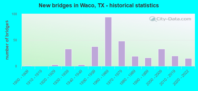
- New bridges - historical statistics
- 11900-1909
- 31920-1929
- 331930-1939
- 31940-1949
- 381950-1959
- 941960-1969
- 481970-1979
- 191980-1989
- 161990-1999
- 332000-2009
- 202010-2019
- 152020-2022

- Reconstructed bridges - Historical Statistics
- 21940-1949
- 111950-1959
- 111960-1969
- 71970-1979
- 121980-1989
- 51990-1999
- 32000-2009
- 32010-2019


- Bridge Condition - Deck
- 13.4%Excellent
- 51.9%Very good
- 19.3%Good
- 14.4%Satisfactory
- 1.1%Fair
- 0.5%Poor

- Bridge Condition - Superstructure
- 16.6%Very good
- 45.5%Good
- 30.5%Satisfactory
- 7.0%Fair
- 0.5%Poor

- Bridge Condition - Substructure
- 8.6%Very good
- 38.5%Good
- 38.0%Satisfactory
- 12.8%Fair
- 2.1%Poor

- Bridge Condition - Channel
- 5.8%Very good
- 33.3%Good
- 49.3%Satisfactory
- 9.7%Fair
- 1.9%Poor

- Bridge Condition - Culverts
- 56.2%Good
- 40.4%Satisfactory
- 3.4%Fair
Find on map >> Show street view
Structure Number: 91610B03452001, Location: 0.02 MI NE OF FM 1695 (Lat: 31.484450, Lng: -97.209128), Route carried "on" structure: City street , Year Built: 1995, Status: Open, Structure Length: 1.07m (3.51ft), Average Daily Traffic: 550 (year 2016), Average Future Daily Traffic: 750 (year 2036), Features Intersected: FLAT CRK #1001 WAC, Facility Carried by Structure: LA VILLAGE AVE
Minimum Vertical Clearance: 30+ m (98+ ft), Kilometerpoint: 0.032, Lanes on structure: 2, Owner: City or Municipal Highway Agency, Approaching Roadway Width: 10.4m (34.1ft), Material/Design: Concrete, Design/Construction: Culvert, Number Of Spans In Main Unit: 4, Length of Maximum Span: 2.4m (7.9ft), Curb-To-Curb Width: 10.4m (34.1ft), Out-to-Out Width: 18.3m (60.0ft)
Condition: Channel: Good, Culverts: Good, Operating Rating: 32.7 metric tons, Method Used To Determine Operating Rating: Field evaluation and documented engineering judgment, Inventory Rating: 24.5 metric tons, Method Used To Determine Inventory Rating: Field evaluation and documented engineering judgment, Structural Evaluation: Equal to present minimum criteria, Deck Geometry: Equal to present minimum criteria, Waterway Adequacy: Better than present minimum criteria, Approach Roadway Alignment: Equal to present desirable criteria, Length Of Structure Improvement: 1.83m (6.00ft), Designated Inspection Frequency: Every 24 months, Inspection Date: Febuary 2020, Bridge Improvement Cost: $167,000, Roadway Improvement Cost: $41,000, Total Project Cost: $208,000, Deck Structure Type: Concrete Cast-file-Place, Wearing Surface/Protective System: Wearing Surface: Bituminous
Find on map >> Show street view
Structure Number: 91610B03621001, Location: 0.25 MI N OF FM 1637 (Lat: 31.574442, Lng: -97.151739), Route carried "on" structure: City street , Year Built: 1950, Status: Open, Structure Length: 0.91m (2.99ft), Average Daily Traffic: 493 (year 2020), Average Future Daily Traffic: 1,500 (year 2036), Design Load: H 15, Features Intersected: WILSON CRK #59 WAC, Facility Carried by Structure: LINDSEY HOLLOW RD
Minimum Vertical Clearance: 30+ m (98+ ft), Kilometerpoint: 1.287, Lanes on structure: 2, Owner: City or Municipal Highway Agency, Approaching Roadway Width: 6.7m (22.0ft), Material/Design: Concrete, Design/Construction: Tee Beam, Number Of Spans In Main Unit: 1, Length of Maximum Span: 8.8m (28.9ft), Curb or Sidewalk Widths: Left: 1.2m (3.9ft), Right: 0.0m, Curb-To-Curb Width: 7.8m (25.6ft), Out-to-Out Width: 9.8m (32.2ft)
Condition: Deck: Good, Superstructure: Good, Substructure: Satisfactory, Channel: Satisfactory, Operating Rating: 55.3 metric tons, Method Used To Determine Operating Rating: Load Factor (LF), Inventory Rating: 32.7 metric tons, Method Used To Determine Inventory Rating: Load Factor (LF), Structural Evaluation: Equal to present minimum criteria, Deck Geometry: Meets minimum limits, Waterway Adequacy: Meets minimum limits, Approach Roadway Alignment: Equal to present desirable criteria, Length Of Structure Improvement: 1.83m (6.00ft), Designated Inspection Frequency: Every 24 months, Inspection Date: Febuary 2020, Bridge Improvement Cost: $170,000, Roadway Improvement Cost: $41,000, Total Project Cost: $255,000, Deck Structure Type: Concrete Cast-file-Place, Wearing Surface/Protective System: Wearing Surface: Bituminous
Find on map >> Show street view
Structure Number: 91610B03916001, Location: 0.20 MI NE OF FM 1695 (Lat: 31.483258, Lng: -97.205000), Route carried "on" structure: City street , Year Built: 1975, Status: Open, Structure Length: 1.16m (3.81ft), Average Daily Traffic: 4,136 (year 2020), Average Future Daily Traffic: 3,000 (year 2036), Features Intersected: FLAT CRK #1004 WAC, Facility Carried by Structure: MARS DR
Minimum Vertical Clearance: 30+ m (98+ ft), Kilometerpoint: 0.322, Lanes on structure: 2, Owner: City or Municipal Highway Agency, Approaching Roadway Width: 8.5m (27.9ft), Skew: 3 degrees, Material/Design: Concrete, Design/Construction: Culvert, Number Of Spans In Main Unit: 3, Length of Maximum Span: 3.7m (12.1ft), Curb-To-Curb Width: 8.5m (27.9ft), Out-to-Out Width: 14.7m (48.2ft)
Condition: Channel: Satisfactory, Culverts: Good, Operating Rating: 32.7 metric tons, Method Used To Determine Operating Rating: Field evaluation and documented engineering judgment, Inventory Rating: 24.5 metric tons, Method Used To Determine Inventory Rating: Field evaluation and documented engineering judgment, Structural Evaluation: Equal to present minimum criteria, Deck Geometry: Meets minimum limits, Waterway Adequacy: Meets minimum limits, Approach Roadway Alignment: Equal to present desirable criteria, Length Of Structure Improvement: 1.83m (6.00ft), Designated Inspection Frequency: Every 24 months, Inspection Date: Febuary 2020, Bridge Improvement Cost: $167,000, Roadway Improvement Cost: $41,000, Total Project Cost: $208,000, Deck Structure Type: Concrete Cast-file-Place, Wearing Surface/Protective System: Wearing Surface: Bituminous
Find on map >> Show street view
Structure Number: 91610B04271001, Location: 0.30 MI NE OF 36th ST (Lat: 31.540919, Lng: -97.162097), Route carried "on" structure: City street , Year Built: 1970, Status: Open, Structure Length: 1.19m (3.90ft), Average Daily Traffic: 983 (year 2020), Average Future Daily Traffic: 2,500 (year 2032), Features Intersected: WACO CRK TRIB #51 WAC, Facility Carried by Structure: MORROW AVE & 31 ST
Minimum Vertical Clearance: 30+ m (98+ ft), Kilometerpoint: 0.483, Lanes on structure: 2, Owner: City or Municipal Highway Agency, Approaching Roadway Width: 7.9m (25.9ft), Skew: 26 degrees, Material/Design: Steel, Design/Construction: Arch - Deck, Number Of Spans In Main Unit: 1, Length of Maximum Span: 11.6m (38.1ft), Curb-To-Curb Width: 8.0m (26.2ft), Out-to-Out Width: 22.4m (73.5ft)
Condition: Deck: Good, Superstructure: Good, Substructure: Good, Channel: Very good, Operating Rating: 32.7 metric tons, Method Used To Determine Operating Rating: Field evaluation and documented engineering judgment, Inventory Rating: 24.5 metric tons, Method Used To Determine Inventory Rating: Field evaluation and documented engineering judgment, Structural Evaluation: Equal to present minimum criteria, Deck Geometry: Somewhat better than minimum adequacy, Waterway Adequacy: Better than present minimum criteria, Approach Roadway Alignment: Equal to present desirable criteria, Length Of Structure Improvement: 1.83m (6.00ft), Designated Inspection Frequency: Every 24 months, Inspection Date: Febuary 2020, Bridge Improvement Cost: $167,000, Roadway Improvement Cost: $41,000, Total Project Cost: $208,000, Deck Structure Type: Corrugated Steel, Wearing Surface/Protective System: Wearing Surface: Bituminous
Find on map >> Show street view
Structure Number: 91610B04371003, Location: 0.25 MI SE OF SPUR 298 (Lat: 31.519789, Lng: -97.167008), Route carried "on" structure: City street 15, Year Built: 1981, Status: Open, Structure Length: 15.30m (50.20ft), Average Daily Traffic: 31,875 (year 2020), Average Future Daily Traffic: 14,300 (year 2036), Design Load: HS 20, Features Intersected: UPRR #55 WAC, Facility Carried by Structure: NEW RD
Minimum Vertical Clearance: 30+ m (98+ ft), Kilometerpoint: 1.481, Lanes on structure: 4, Owner: City or Municipal Highway Agency, Approaching Roadway Width: 15.5m (50.9ft), Material/Design: Concrete continuous, Design/Construction: Slab, Number Of Spans In Main Unit: 10, Length of Maximum Span: 18.3m (60.0ft), Curb or Sidewalk Widths: Left: 0.0m, Right: 1.2m (3.9ft), Curb-To-Curb Width: 15.5m (50.9ft), Out-to-Out Width: 17.8m (58.4ft)
Condition: Deck: Good, Superstructure: Satisfactory, Substructure: Fair, Operating Rating: 59.9 metric tons, Method Used To Determine Operating Rating: Load Factor (LF), Inventory Rating: 36.3 metric tons, Method Used To Determine Inventory Rating: Load Factor (LF), Structural Evaluation: Somewhat better than minimum adequacy, Deck Geometry: Meets minimum limits, Underclear: Equal to present minimum criteria, Approach Roadway Alignment: Equal to present desirable criteria, Length Of Structure Improvement: 19.05m (62.50ft), Designated Inspection Frequency: Every 24 months, Inspection Date: April 2020, Bridge Improvement Cost: $1,747,000, Roadway Improvement Cost: $436,000, Total Project Cost: $2,183,000, Deck Structure Type: Concrete Cast-file-Place, Wearing Surface/Protective System: Wearing Surface: Bituminous
Find on map >> Show street view
Structure Number: 91610B04431001, Location: 0.10 MI S OF 30TH ST (Lat: 31.536358, Lng: -97.157711), Route carried "on" structure: City street , Year Built: 1930, Status: Open, Structure Length: 0.85m (2.79ft), Average Daily Traffic: 100 (year 2020), Average Future Daily Traffic: 220 (year 2036), Features Intersected: WACO CRK TRIB #13 WAC, Facility Carried by Structure: NOVICE RD
Minimum Vertical Clearance: 30+ m (98+ ft), Kilometerpoint: 0.161, Lanes on structure: 2, Owner: City or Municipal Highway Agency, Approaching Roadway Width: 8.5m (27.9ft), Material/Design: Concrete, Design/Construction: Arch - Deck, Number Of Spans In Main Unit: 1, Length of Maximum Span: 8.2m (26.9ft), Curb-To-Curb Width: 8.5m (27.9ft), Out-to-Out Width: 9.3m (30.5ft)
Condition: Deck: Good, Superstructure: Good, Substructure: Good, Channel: Good, Operating Rating: 32.7 metric tons, Method Used To Determine Operating Rating: Field evaluation and documented engineering judgment, Inventory Rating: 24.5 metric tons, Method Used To Determine Inventory Rating: Field evaluation and documented engineering judgment, Structural Evaluation: Equal to present minimum criteria, Deck Geometry: Better than present minimum criteria, Waterway Adequacy: Better than present minimum criteria, Approach Roadway Alignment: Equal to present desirable criteria, Length Of Structure Improvement: 1.83m (6.00ft), Designated Inspection Frequency: Every 24 months, Inspection Date: Febuary 2020, Bridge Improvement Cost: $167,000, Roadway Improvement Cost: $41,000, Total Project Cost: $208,000, Deck Structure Type: Concrete Cast-file-Place, Wearing Surface/Protective System: Wearing Surface: Bituminous
Find on map >> Show street view
Structure Number: 91610B04641001, Location: 0.10 MI SE OF US 84 (Lat: 31.536181, Lng: -97.158992), Route carried "on" structure: City street , Year Built: 1920, Year Reconstructed: 1950, Status: Open, Structure Length: 0.79m (2.59ft), Average Daily Traffic: 530 (year 2012), Average Future Daily Traffic: 750 (year 2032), Features Intersected: WACO CRK TRIB #12 WAC, Facility Carried by Structure: ORIENTAL RD
Minimum Vertical Clearance: 30+ m (98+ ft), Kilometerpoint: 0.161, Lanes on structure: 2, Owner: City or Municipal Highway Agency, Approaching Roadway Width: 8.2m (26.9ft), Material/Design: Concrete, Design/Construction: Culvert, Number Of Spans In Main Unit: 4, Length of Maximum Span: 1.8m (5.9ft), Curb or Sidewalk Widths: Left: 0.0m, Right: 1.2m (3.9ft), Curb-To-Curb Width: 8.2m (26.9ft), Out-to-Out Width: 12.1m (39.7ft)
Condition: Channel: Satisfactory, Culverts: Satisfactory, Operating Rating: 32.7 metric tons, Method Used To Determine Operating Rating: Field evaluation and documented engineering judgment, Inventory Rating: 24.5 metric tons, Method Used To Determine Inventory Rating: Field evaluation and documented engineering judgment, Structural Evaluation: Equal to present minimum criteria, Deck Geometry: Somewhat better than minimum adequacy, Waterway Adequacy: Meets minimum limits, Approach Roadway Alignment: Equal to present desirable criteria, Length Of Structure Improvement: 1.83m (6.00ft), Designated Inspection Frequency: Every 24 months, Inspection Date: Febuary 2020, Bridge Improvement Cost: $167,000, Roadway Improvement Cost: $41,000, Total Project Cost: $208,000, Deck Structure Type: Concrete Cast-file-Place, Wearing Surface/Protective System: Wearing Surface: Bituminous
Find on map >> Show street view
Structure Number: 91610B05452001, Location: 1.75 MI NE OF SH 6 (Lat: 31.556103, Lng: -97.252231), Route carried "on" structure: City street 414, Year Built: 1920, Status: Closed, Structure Length: 2.13m (6.99ft), Average Daily Traffic: 100 (year 2020), Average Future Daily Traffic: 300 (year 2036), Features Intersected: SPEEGLEVILLE CRK #906WAC, Facility Carried by Structure: SAN ANN RD
Minimum Vertical Clearance: 30+ m (98+ ft), Kilometerpoint: 2.816, Lanes on structure: 2, Owner: City or Municipal Highway Agency, Approaching Roadway Width: 4.9m (16.1ft), Material/Design: Steel continuous, Design/Construction: Stringer/Multi-beam, Number Of Spans In Main Unit: 1, Number Of Approach Spans: 2, Length of Maximum Span: 10.4m (34.1ft), Curb-To-Curb Width: 5.9m (19.4ft), Out-to-Out Width: 6.1m (20.0ft)
Condition: Deck: Fair, Superstructure: Satisfactory, Substructure: Poor, Channel: Satisfactory, Deck Geometry: Meets minimum limits, Waterway Adequacy: Meets minimum limits, Approach Roadway Alignment: Equal to present minimum criteria, Bridge Posting: Required (Relationship of Operating Rating to Maximum Legal Load: > 39.9% below), Length Of Structure Improvement: 2.87m (9.42ft), Designated Inspection Frequency: Every 24 months, Critical Feature Inspection Frequency: Every 24 months, Inspection Date: March 2020, Critical Feature Inspection Date: July 2018, Bridge Improvement Cost: $176,000, Roadway Improvement Cost: $44,000, Total Project Cost: $220,000, Deck Structure Type: Wood or Timber, Wearing Surface/Protective System: Wearing Surface: Gravel
Find on map >> Show street view
Structure Number: 91610B05461001, Location: 0.40 MI NE OF 36TH ST (Lat: 31.541144, Lng: -97.159786), Route carried "on" structure: City street , Year Built: 1950, Year Reconstructed: 1977, Status: Open, Structure Length: 0.94m (3.08ft), Average Daily Traffic: 271 (year 2020), Average Future Daily Traffic: 500 (year 2036), Features Intersected: WACO CRK TRIB #49 WAC, Facility Carried by Structure: SANGER AVE
Minimum Vertical Clearance: 30+ m (98+ ft), Kilometerpoint: 0.644, Lanes on structure: 2, Owner: City or Municipal Highway Agency, Approaching Roadway Width: 11.0m (36.1ft), Skew: 3 degrees, Material/Design: Concrete, Design/Construction: Culvert, Number Of Spans In Main Unit: 2, Length of Maximum Span: 3.7m (12.1ft), Curb-To-Curb Width: 12.2m (40.0ft), Out-to-Out Width: 25.8m (84.6ft)
Condition: Channel: Good, Culverts: Satisfactory, Operating Rating: 32.7 metric tons, Method Used To Determine Operating Rating: Field evaluation and documented engineering judgment, Inventory Rating: 24.5 metric tons, Method Used To Determine Inventory Rating: Field evaluation and documented engineering judgment, Structural Evaluation: Equal to present minimum criteria, Deck Geometry: Superior to present desirable criteria, Waterway Adequacy: Better than present minimum criteria, Approach Roadway Alignment: Equal to present desirable criteria, Length Of Structure Improvement: 1.83m (6.00ft), Designated Inspection Frequency: Every 24 months, Inspection Date: Febuary 2020, Bridge Improvement Cost: $167,000, Roadway Improvement Cost: $41,000, Total Project Cost: $208,000, Deck Structure Type: Concrete Cast-file-Place, Wearing Surface/Protective System: Wearing Surface: Bituminous
Find on map >> Show street view
Structure Number: 91610B05461002, Location: 0.20 MI SW OF LP 396 (Lat: 31.527433, Lng: -97.180464), Route carried "on" structure: City street , Year Built: 1968, Status: Open, Structure Length: 1.34m (4.40ft), Average Daily Traffic: 13,859 (year 2020), Average Future Daily Traffic: 18,000 (year 2036), Features Intersected: WACO CRK #9 WAC, Facility Carried by Structure: SANGER AVE
Minimum Vertical Clearance: 30+ m (98+ ft), Kilometerpoint: 2.414, Lanes on structure: 4, Owner: City or Municipal Highway Agency, Approaching Roadway Width: 13.4m (44.0ft), Skew: 1 degrees, Material/Design: Concrete, Design/Construction: Culvert, Number Of Spans In Main Unit: 5, Length of Maximum Span: 2.4m (7.9ft), Curb or Sidewalk Widths: Left: 1.9m (6.2ft), Right: 2.3m (7.5ft), Curb-To-Curb Width: 13.4m (44.0ft), Out-to-Out Width: 18.3m (60.0ft)
Condition: Channel: Poor, Culverts: Satisfactory, Operating Rating: 32.7 metric tons, Method Used To Determine Operating Rating: Field evaluation and documented engineering judgment, Inventory Rating: 24.5 metric tons, Method Used To Determine Inventory Rating: Field evaluation and documented engineering judgment, Structural Evaluation: Equal to present minimum criteria, Deck Geometry: High priority of replacement, Waterway Adequacy: Equal to present minimum criteria, Approach Roadway Alignment: Equal to present desirable criteria, Length Of Structure Improvement: 1.83m (6.00ft), Designated Inspection Frequency: Every 24 months, Inspection Date: Febuary 2020, Bridge Improvement Cost: $251,000, Roadway Improvement Cost: $62,000, Total Project Cost: $313,000, Deck Structure Type: Concrete Cast-file-Place, Wearing Surface/Protective System: Wearing Surface: Bituminous
Find on map >> Show street view
Structure Number: 91610B05781001, Location: 0.20 MI NW OF MLK BLVD (Lat: 31.559831, Lng: -97.107297), Route carried "on" structure: City street , Year Built: 1971, Status: Open, Structure Length: 1.65m (5.41ft), Average Daily Traffic: 1,700 (year 2016), Average Future Daily Traffic: 2,000 (year 2036), Features Intersected: MARLIN BR #4 WAC, Facility Carried by Structure: SPRING ST
Minimum Vertical Clearance: 30+ m (98+ ft), Kilometerpoint: 0.483, Lanes on structure: 2, Owner: City or Municipal Highway Agency, Approaching Roadway Width: 7.9m (25.9ft), Material/Design: Concrete, Design/Construction: Culvert, Number Of Spans In Main Unit: 5, Length of Maximum Span: 3.0m (9.8ft), Curb or Sidewalk Widths: Left: 0.0m, Right: 1.2m (3.9ft), Curb-To-Curb Width: 12.7m (41.7ft), Out-to-Out Width: 14.5m (47.6ft)
Condition: Channel: Satisfactory, Culverts: Good, Operating Rating: 32.7 metric tons, Method Used To Determine Operating Rating: Field evaluation and documented engineering judgment, Inventory Rating: 24.5 metric tons, Method Used To Determine Inventory Rating: Field evaluation and documented engineering judgment, Structural Evaluation: Equal to present minimum criteria, Deck Geometry: Better than present minimum criteria, Waterway Adequacy: Better than present minimum criteria, Approach Roadway Alignment: Equal to present desirable criteria, Length Of Structure Improvement: 2.74m (8.99ft), Designated Inspection Frequency: Every 24 months, Inspection Date: April 2020, Bridge Improvement Cost: $251,000, Roadway Improvement Cost: $62,000, Total Project Cost: $313,000, Deck Structure Type: Concrete Cast-file-Place, Wearing Surface/Protective System: Wearing Surface: Bituminous
Find on map >> Show street view
Structure Number: 91610B05911001, Location: 0.01 MI NW OF UNIV PARK (Lat: 31.574244, Lng: -97.147425), Route carried "on" structure: City street , Year Built: 1930, Status: Open, Structure Length: 1.34m (4.40ft), Average Daily Traffic: 3,583 (year 2020), Average Future Daily Traffic: 2,510 (year 2032), Features Intersected: WILSON CRK #33 WAC, Facility Carried by Structure: STURGIS LN
Minimum Vertical Clearance: 30+ m (98+ ft), Kilometerpoint: 0.483, Lanes on structure: 2, Owner: City or Municipal Highway Agency, Approaching Roadway Width: 8.5m (27.9ft), Material/Design: Concrete, Design/Construction: Arch - Deck, Number Of Spans In Main Unit: 1, Length of Maximum Span: 12.8m (42.0ft), Curb-To-Curb Width: 10.0m (32.8ft), Out-to-Out Width: 11.1m (36.4ft)
Condition: Deck: Good, Superstructure: Satisfactory, Substructure: Satisfactory, Channel: Fair, Operating Rating: 32.7 metric tons, Method Used To Determine Operating Rating: Field evaluation and documented engineering judgment, Inventory Rating: 24.5 metric tons, Method Used To Determine Inventory Rating: Field evaluation and documented engineering judgment, Structural Evaluation: Equal to present minimum criteria, Deck Geometry: Meets minimum limits, Waterway Adequacy: Better than present minimum criteria, Approach Roadway Alignment: Equal to present desirable criteria, Length Of Structure Improvement: 1.83m (6.00ft), Designated Inspection Frequency: Every 24 months, Inspection Date: Febuary 2020, Bridge Improvement Cost: $167,000, Roadway Improvement Cost: $41,000, Total Project Cost: $208,000, Deck Structure Type: Concrete Cast-file-Place, Wearing Surface/Protective System: Wearing Surface: Bituminous
Find on map >> Show street view
Structure Number: 91610B06065001, Location: 0.30 MI SW OF FM 3476 (Lat: 31.490169, Lng: -97.172619), Route carried "on" structure: City street , Year Built: 1995, Status: Open, Structure Length: 2.44m (8.01ft), Average Daily Traffic: 560 (year 2016), Average Future Daily Traffic: 750 (year 2036), Design Load: HS 20, Features Intersected: N FLAT CRK #1006 WAC, Facility Carried by Structure: TX CENT PKWY
Minimum Vertical Clearance: 30+ m (98+ ft), Kilometerpoint: 0.032, Lanes on structure: 4, Owner: City or Municipal Highway Agency, Approaching Roadway Width: 17.1m (56.1ft), Skew: 20 degrees, Material/Design: Prestressed concrete, Design/Construction: Stringer/Multi-beam, Number Of Spans In Main Unit: 1, Length of Maximum Span: 24.4m (80.1ft), Curb-To-Curb Width: 20.1m (65.9ft), Out-to-Out Width: 22.1m (72.5ft)
Condition: Deck: Good, Superstructure: Very good, Substructure: Good, Channel: Satisfactory, Operating Rating: 54.4 metric tons, Method Used To Determine Operating Rating: Assigned rating based on Load Factor Design (LFD) reported in metric tons, Inventory Rating: 32.7 metric tons, Method Used To Determine Inventory Rating: Assigned rating based on Load Factor Design (LFD) reported in metric tons, Structural Evaluation: Better than present minimum criteria, Deck Geometry: Better than present minimum criteria, Waterway Adequacy: Better than present minimum criteria, Approach Roadway Alignment: Equal to present desirable criteria, Length Of Structure Improvement: 3.05m (10.01ft), Designated Inspection Frequency: Every 24 months, Inspection Date: Febuary 2020, Bridge Improvement Cost: $279,000, Roadway Improvement Cost: $70,000, Total Project Cost: $349,000, Deck Structure Type: Concrete Cast-file-Place
Find on map >> Show street view
Structure Number: 91610B06162001, Location: 0.15 MI NW WASHINGTON AVE (Lat: 31.561753, Lng: -97.130711), Route carried "on" structure: City street 6162, Year Built: 2008, Status: Open, Structure Length: 2.13m (6.99ft), Average Daily Traffic: 250 (year 2014), Truck Traffic: 1%, Average Future Daily Traffic: 350 (year 2036), Design Load: HS 20, Features Intersected: BARRONS BRANCH #1007 WAC, Facility Carried by Structure: UNIVERSITY PKS(EB)
Minimum Vertical Clearance: 30+ m (98+ ft), Kilometerpoint: 0.002, Lanes on structure: 2, Owner: City or Municipal Highway Agency, Approaching Roadway Width: 7.3m (24.0ft), Skew: 1 degrees, Material/Design: Prestressed concrete, Design/Construction: Stringer/Multi-beam, Number Of Spans In Main Unit: 1, Length of Maximum Span: 21.3m (69.9ft), Curb or Sidewalk Widths: Left: 2.3m (7.5ft), Right: 0.0m, Curb-To-Curb Width: 7.3m (24.0ft), Out-to-Out Width: 10.4m (34.1ft)
Condition: Deck: Good, Superstructure: Very good, Substructure: Good, Channel: Good, Operating Rating: 54.4 metric tons, Method Used To Determine Operating Rating: Assigned rating based on Load Factor Design (LFD) reported in metric tons, Inventory Rating: 32.7 metric tons, Method Used To Determine Inventory Rating: Assigned rating based on Load Factor Design (LFD) reported in metric tons, Structural Evaluation: Better than present minimum criteria, Deck Geometry: High priority of replacement, Waterway Adequacy: Equal to present minimum criteria, Approach Roadway Alignment: Equal to present desirable criteria, Designated Inspection Frequency: Every 24 months, Inspection Date: April 2020, Deck Structure Type: Concrete Cast-file-Place
Find on map >> Show street view
Structure Number: 91610B06162002, Location: 0.15 MI NW WASHINGTON AVE (Lat: 31.561831, Lng: -97.130347), Route carried "on" structure: City street 6162, Year Built: 2008, Status: Open, Structure Length: 2.13m (6.99ft), Average Daily Traffic: 250 (year 2014), Truck Traffic: 1%, Average Future Daily Traffic: 350 (year 2036), Design Load: HS 20, Features Intersected: BARRONS BRANCH #1008 WAC, Facility Carried by Structure: UNIVERSITY PKS(WB)
Minimum Vertical Clearance: 30+ m (98+ ft), Kilometerpoint: 0.002, Lanes on structure: 2, Owner: City or Municipal Highway Agency, Approaching Roadway Width: 7.3m (24.0ft), Skew: 1 degrees, Material/Design: Prestressed concrete, Design/Construction: Stringer/Multi-beam, Number Of Spans In Main Unit: 1, Length of Maximum Span: 21.3m (69.9ft), Curb or Sidewalk Widths: Left: 0.0m, Right: 2.3m (7.5ft), Curb-To-Curb Width: 7.3m (24.0ft), Out-to-Out Width: 10.4m (34.1ft)
Condition: Deck: Very good, Superstructure: Very good, Substructure: Good, Channel: Satisfactory, Operating Rating: 54.4 metric tons, Method Used To Determine Operating Rating: Assigned rating based on Load Factor Design (LFD) reported in metric tons, Inventory Rating: 32.7 metric tons, Method Used To Determine Inventory Rating: Assigned rating based on Load Factor Design (LFD) reported in metric tons, Structural Evaluation: Better than present minimum criteria, Deck Geometry: High priority of replacement, Waterway Adequacy: Equal to present minimum criteria, Approach Roadway Alignment: Equal to present desirable criteria, Designated Inspection Frequency: Every 24 months, Inspection Date: April 2020, Deck Structure Type: Concrete Cast-file-Place
Find on map >> Show street view
Structure Number: 91610B06361001, Location: 0.20 MI SW OF 11TH ST (Lat: 31.546622, Lng: -97.135875), Route carried "on" structure: City street , Year Built: 1930, Status: Posted for load, Structure Length: 1.16m (3.81ft), Average Daily Traffic: 1,389 (year 2020), Truck Traffic: 1%, Average Future Daily Traffic: 4,750 (year 2032), Features Intersected: WACO CRK #23 WAC, Facility Carried by Structure: WEBSTER AVE
Minimum Vertical Clearance: 30+ m (98+ ft), Kilometerpoint: 1.529, Lanes on structure: 3, Owner: City or Municipal Highway Agency, Approaching Roadway Width: 16.5m (54.1ft), Skew: 4 degrees, Material/Design: Masonry, Design/Construction: Arch - Deck, Number Of Spans In Main Unit: 1, Length of Maximum Span: 11.0m (36.1ft), Curb or Sidewalk Widths: Left: 1.2m (3.9ft), Right: 1.2m (3.9ft), Curb-To-Curb Width: 16.6m (54.5ft), Out-to-Out Width: 23.1m (75.8ft)
Condition: Deck: Fair, Superstructure: Fair, Substructure: Fair, Channel: Fair, Operating Rating: 68.0 metric tons, Method Used To Determine Operating Rating: Allowable Stress (AS), Inventory Rating: 22.7 metric tons, Method Used To Determine Inventory Rating: Allowable Stress (AS), Structural Evaluation: Somewhat better than minimum adequacy, Deck Geometry: Equal to present desirable criteria, Waterway Adequacy: Better than present minimum criteria, Approach Roadway Alignment: Equal to present desirable criteria, Length Of Structure Improvement: 1.83m (6.00ft), Designated Inspection Frequency: Every 24 months, Inspection Date: Febuary 2020, Bridge Improvement Cost: $167,000, Roadway Improvement Cost: $41,000, Total Project Cost: $208,000, Deck Structure Type: Other, Wearing Surface/Protective System: Wearing Surface: Bituminous
Find on map >> Show street view
Structure Number: 91610B06785001, Location: 1.40 MI E OF US 84 (Lat: 31.547914, Lng: -97.117353), Route carried "on" structure: City street , Year Built: 1962, Status: Open, Structure Length: 1.40m (4.59ft), Average Daily Traffic: 4,600 (year 2016), Average Future Daily Traffic: 5,000 (year 2036), Features Intersected: WACO CRK #38 WAC, Facility Carried by Structure: 3RD ST
Minimum Vertical Clearance: 30+ m (98+ ft), Kilometerpoint: 2.253, Lanes on structure: 2, Owner: City or Municipal Highway Agency, Approaching Roadway Width: 11.0m (36.1ft), Skew: 4 degrees, Material/Design: Concrete, Design/Construction: Culvert, Number Of Spans In Main Unit: 3, Length of Maximum Span: 3.0m (9.8ft)
Condition: Channel: Good, Culverts: Satisfactory, Operating Rating: 32.7 metric tons, Method Used To Determine Operating Rating: Field evaluation and documented engineering judgment, Inventory Rating: 24.5 metric tons, Method Used To Determine Inventory Rating: Field evaluation and documented engineering judgment, Structural Evaluation: Equal to present minimum criteria, Waterway Adequacy: Better than present minimum criteria, Approach Roadway Alignment: Equal to present desirable criteria, Length Of Structure Improvement: 1.83m (6.00ft), Designated Inspection Frequency: Every 24 months, Inspection Date: April 2020, Bridge Improvement Cost: $174,000, Roadway Improvement Cost: $41,000, Total Project Cost: $215,000
Find on map >> Show street view
Structure Number: 91610B06785002, Location: 0.50 MI NW OF FM 434 (Lat: 31.529683, Lng: -97.095975), Route carried "on" structure: City street , Year Built: 1990, Status: Open, Structure Length: 3.14m (10.30ft), Average Daily Traffic: 644 (year 2020), Average Future Daily Traffic: 1,500 (year 2036), Design Load: HS 20, Features Intersected: PRIMROSE CRK #41 WAC, Facility Carried by Structure: 3RD ST
Minimum Vertical Clearance: 30+ m (98+ ft), Kilometerpoint: 5.069, Lanes on structure: 2, Owner: City or Municipal Highway Agency, Approaching Roadway Width: 9.1m (29.9ft), Skew: 4 degrees, Material/Design: Concrete, Design/Construction: Stringer/Multi-beam, Number Of Spans In Main Unit: 3, Length of Maximum Span: 10.4m (34.1ft), Curb-To-Curb Width: 11.4m (37.4ft), Out-to-Out Width: 12.3m (40.4ft)
Condition: Deck: Good, Superstructure: Good, Substructure: Good, Channel: Satisfactory, Operating Rating: 68.0 metric tons, Method Used To Determine Operating Rating: Load Factor (LF), Inventory Rating: 40.8 metric tons, Method Used To Determine Inventory Rating: Load Factor (LF), Structural Evaluation: Better than present minimum criteria, Deck Geometry: Better than present minimum criteria, Waterway Adequacy: Better than present minimum criteria, Approach Roadway Alignment: Equal to present desirable criteria, Length Of Structure Improvement: 3.96m (12.99ft), Designated Inspection Frequency: Every 24 months, Inspection Date: April 2020, Bridge Improvement Cost: $363,000, Roadway Improvement Cost: $90,000, Total Project Cost: $453,000, Deck Structure Type: Concrete Cast-file-Place, Wearing Surface/Protective System: Wearing Surface: Bituminous
Find on map >> Show street view
Structure Number: 91610B06787001, Location: 0.20 MI SE OF IH 35 (Lat: 31.547778, Lng: -97.121283), Route carried "on" structure: City street , Year Built: 1930, Status: Posted for load, Structure Length: 1.40m (4.59ft), Average Daily Traffic: 475 (year 2016), Average Future Daily Traffic: 3,000 (year 2036), Features Intersected: WACO CRK #37 WAC, Facility Carried by Structure: 5TH ST
Minimum Vertical Clearance: 30+ m (98+ ft), Kilometerpoint: 2.092, Lanes on structure: 2, Owner: City or Municipal Highway Agency, Approaching Roadway Width: 12.2m (40.0ft), Skew: 2 degrees, Material/Design: Concrete, Design/Construction: Arch - Deck, Number Of Spans In Main Unit: 1, Length of Maximum Span: 13.7m (44.9ft), Curb or Sidewalk Widths: Left: 3.5m (11.5ft), Right: 3.5m (11.5ft), Curb-To-Curb Width: 12.1m (39.7ft), Out-to-Out Width: 19.9m (65.3ft)
Condition: Deck: Good, Superstructure: Good, Substructure: Good, Channel: Good, Operating Rating: 32.7 metric tons, Method Used To Determine Operating Rating: Field evaluation and documented engineering judgment, Inventory Rating: 24.5 metric tons, Method Used To Determine Inventory Rating: Field evaluation and documented engineering judgment, Structural Evaluation: Equal to present minimum criteria, Deck Geometry: Better than present minimum criteria, Waterway Adequacy: Better than present minimum criteria, Approach Roadway Alignment: Equal to present desirable criteria, Length Of Structure Improvement: 1.83m (6.00ft), Designated Inspection Frequency: Every 24 months, Inspection Date: April 2020, Bridge Improvement Cost: $167,000, Roadway Improvement Cost: $41,000, Total Project Cost: $208,000, Deck Structure Type: Concrete Cast-file-Place, Wearing Surface/Protective System: Wearing Surface: Bituminous
Find on map >> Show street view
Structure Number: 91610B06787002, Location: 1.05 MI SE OF LP 491 (Lat: 31.530078, Lng: -97.099911), Route carried "on" structure: City street , Year Built: 1983, Status: Open, Structure Length: 3.14m (10.30ft), Average Daily Traffic: 389 (year 2020), Average Future Daily Traffic: 580 (year 2036), Design Load: HS 20, Features Intersected: PRIMROSE CRK #42 WAC, Facility Carried by Structure: 4TH ST
Minimum Vertical Clearance: 30+ m (98+ ft), Kilometerpoint: 5.069, Lanes on structure: 2, Owner: City or Municipal Highway Agency, Approaching Roadway Width: 9.1m (29.9ft), Skew: 4 degrees, Material/Design: Concrete, Design/Construction: Stringer/Multi-beam, Number Of Spans In Main Unit: 3, Length of Maximum Span: 10.4m (34.1ft), Curb-To-Curb Width: 10.4m (34.1ft), Out-to-Out Width: 11.1m (36.4ft)
Condition: Deck: Good, Superstructure: Good, Substructure: Good, Channel: Good, Operating Rating: 68.0 metric tons, Method Used To Determine Operating Rating: Load Factor (LF), Inventory Rating: 40.8 metric tons, Method Used To Determine Inventory Rating: Load Factor (LF), Structural Evaluation: Better than present minimum criteria, Deck Geometry: Better than present minimum criteria, Waterway Adequacy: Better than present minimum criteria, Approach Roadway Alignment: Equal to present desirable criteria, Length Of Structure Improvement: 3.96m (12.99ft), Designated Inspection Frequency: Every 24 months, Inspection Date: April 2020, Bridge Improvement Cost: $363,000, Roadway Improvement Cost: $90,000, Total Project Cost: $453,000, Deck Structure Type: Concrete Cast-file-Place
Find on map >> Show street view
Structure Number: 91610B06787003, Location: 0.18 MI N OF FM 1637 (Lat: 31.574381, Lng: -97.149314), Route carried "on" structure: City street , Year Built: 1960, Status: Open, Structure Length: 0.79m (2.59ft), Average Daily Traffic: 345 (year 2020), Average Future Daily Traffic: 300 (year 2032), Features Intersected: WILSON CRK #58 WAC, Facility Carried by Structure: 4TH ST
Minimum Vertical Clearance: 30+ m (98+ ft), Kilometerpoint: 1.448, Lanes on structure: 2, Owner: City or Municipal Highway Agency, Approaching Roadway Width: 7.3m (24.0ft), Material/Design: Steel, Design/Construction: Arch - Deck, Number Of Spans In Main Unit: 1, Length of Maximum Span: 7.3m (24.0ft), Curb-To-Curb Width: 9.5m (31.2ft), Out-to-Out Width: 10.2m (33.5ft)
Condition: Deck: Very good, Superstructure: Very good, Substructure: Good, Channel: Satisfactory, Operating Rating: 32.7 metric tons, Method Used To Determine Operating Rating: Field evaluation and documented engineering judgment, Inventory Rating: 24.5 metric tons, Method Used To Determine Inventory Rating: Field evaluation and documented engineering judgment, Structural Evaluation: Equal to present minimum criteria, Deck Geometry: Equal to present minimum criteria, Waterway Adequacy: Meets minimum limits, Approach Roadway Alignment: Equal to present desirable criteria, Length Of Structure Improvement: 1.83m (6.00ft), Designated Inspection Frequency: Every 24 months, Inspection Date: Febuary 2020, Bridge Improvement Cost: $167,000, Roadway Improvement Cost: $41,000, Total Project Cost: $208,000, Deck Structure Type: Corrugated Steel, Wearing Surface/Protective System: Wearing Surface: Bituminous
Find on map >> Show street view
Structure Number: 91610B06793001, Location: 0.15 MI SE OF IH 35 (Lat: 31.546189, Lng: -97.122717), Route carried "on" structure: City street , Year Built: 1969, Status: Open, Structure Length: 1.40m (4.59ft), Average Daily Traffic: 5,530 (year 2016), Average Future Daily Traffic: 7,500 (year 2036), Features Intersected: WACO CRK #28 WAC, Facility Carried by Structure: 7TH ST
Minimum Vertical Clearance: 30+ m (98+ ft), Kilometerpoint: 1.851, Lanes on structure: 2, Owner: City or Municipal Highway Agency, Approaching Roadway Width: 7.6m (24.9ft), Skew: 4 degrees, Material/Design: Concrete, Design/Construction: Culvert, Number Of Spans In Main Unit: 3, Length of Maximum Span: 3.0m (9.8ft), Curb or Sidewalk Widths: Left: 1.5m (4.9ft), Right: 1.5m (4.9ft)
Condition: Channel: Good, Culverts: Good, Operating Rating: 39.9 metric tons, Method Used To Determine Operating Rating: Load Factor (LF), Inventory Rating: 23.6 metric tons, Method Used To Determine Inventory Rating: Load Factor (LF), Structural Evaluation: Somewhat better than minimum adequacy, Waterway Adequacy: Equal to present minimum criteria, Approach Roadway Alignment: Equal to present desirable criteria, Length Of Structure Improvement: 1.83m (6.00ft), Designated Inspection Frequency: Every 24 months, Inspection Date: April 2020, Bridge Improvement Cost: $167,000, Roadway Improvement Cost: $41,000, Total Project Cost: $208,000, Deck Structure Type: Concrete Cast-file-Place, Wearing Surface/Protective System: Wearing Surface: Bituminous
Find on map >> Show street view
Structure Number: 91610B06795001, Location: 0.10 MI SE OF IH 35 (Lat: 31.545686, Lng: -97.123822), Route carried "on" structure: City street , Year Built: 1990, Status: Open, Structure Length: 1.59m (5.22ft), Average Daily Traffic: 10,900 (year 2016), Average Future Daily Traffic: 12,000 (year 2036), Design Load: HS 20, Features Intersected: WACO CRK #27 WAC, Facility Carried by Structure: 8TH ST
Minimum Vertical Clearance: 30+ m (98+ ft), Kilometerpoint: 2.012, Lanes on structure: 2, Owner: City or Municipal Highway Agency, Approaching Roadway Width: 12.8m (42.0ft), Material/Design: Prestressed concrete, Design/Construction: Stringer/Multi-beam, Number Of Spans In Main Unit: 1, Length of Maximum Span: 15.5m (50.9ft), Curb or Sidewalk Widths: Left: 1.7m (5.6ft), Right: 1.7m (5.6ft), Curb-To-Curb Width: 12.8m (42.0ft), Out-to-Out Width: 16.7m (54.8ft)
Condition: Deck: Good, Superstructure: Good, Substructure: Good, Channel: Satisfactory, Operating Rating: 54.4 metric tons, Method Used To Determine Operating Rating: Assigned rating based on Load Factor Design (LFD) reported in metric tons, Inventory Rating: 32.7 metric tons, Method Used To Determine Inventory Rating: Assigned rating based on Load Factor Design (LFD) reported in metric tons, Structural Evaluation: Better than present minimum criteria, Deck Geometry: Somewhat better than minimum adequacy, Waterway Adequacy: Equal to present minimum criteria, Approach Roadway Alignment: Equal to present desirable criteria, Length Of Structure Improvement: 2.74m (8.99ft), Designated Inspection Frequency: Every 24 months, Inspection Date: April 2020, Bridge Improvement Cost: $251,000, Roadway Improvement Cost: $62,000, Total Project Cost: $313,000, Deck Structure Type: Concrete Precast Panels, Wearing Surface/Protective System: Wearing Surface: Bituminous
Find on map >> Show street view
Structure Number: 91610B06797001, Location: 0.05 MI SE OF IH 35 (Lat: 31.544756, Lng: -97.124989), Route carried "on" structure: City street , Year Built: 1935, Status: Posted for load, Structure Length: 1.16m (3.81ft), Average Daily Traffic: 1,000 (year 2016), Average Future Daily Traffic: 1,500 (year 2036), Features Intersected: WACO CRK #26 WAC, Facility Carried by Structure: 9TH ST
Minimum Vertical Clearance: 30+ m (98+ ft), Kilometerpoint: 2.012, Lanes on structure: 2, Owner: City or Municipal Highway Agency, Approaching Roadway Width: 7.9m (25.9ft), Material/Design: Concrete, Design/Construction: Tee Beam, Number Of Spans In Main Unit: 1, Length of Maximum Span: 11.3m (37.1ft), Curb-To-Curb Width: 7.3m (24.0ft), Out-to-Out Width: 8.1m (26.6ft)
Condition: Deck: Good, Superstructure: Satisfactory, Substructure: Good, Channel: Satisfactory, Operating Rating: 32.7 metric tons, Method Used To Determine Operating Rating: Field evaluation and documented engineering judgment, Inventory Rating: 24.5 metric tons, Method Used To Determine Inventory Rating: Field evaluation and documented engineering judgment, Structural Evaluation: Equal to present minimum criteria, Deck Geometry: Meets minimum limits, Waterway Adequacy: Better than present minimum criteria, Approach Roadway Alignment: Equal to present desirable criteria, Length Of Structure Improvement: 1.83m (6.00ft), Designated Inspection Frequency: Every 24 months, Inspection Date: April 2020, Bridge Improvement Cost: $167,000, Roadway Improvement Cost: $41,000, Total Project Cost: $208,000, Deck Structure Type: Concrete Cast-file-Place, Wearing Surface/Protective System: Wearing Surface: Bituminous
Find on map >> Show street view
Structure Number: 91610B06799001, Location: 0.03 MI SE OF IH 35 (Lat: 31.544139, Lng: -97.125792), Route carried "on" structure: City street , Year Built: 1935, Status: Posted for load, Structure Length: 1.16m (3.81ft), Average Daily Traffic: 1,000 (year 2016), Average Future Daily Traffic: 1,500 (year 2036), Features Intersected: WACO CRK #25 WAC, Facility Carried by Structure: 10TH ST
Minimum Vertical Clearance: 30+ m (98+ ft), Kilometerpoint: 2.012, Lanes on structure: 2, Owner: City or Municipal Highway Agency, Approaching Roadway Width: 8.5m (27.9ft), Material/Design: Concrete, Design/Construction: Tee Beam, Number Of Spans In Main Unit: 1, Length of Maximum Span: 11.3m (37.1ft), Curb-To-Curb Width: 7.3m (24.0ft), Out-to-Out Width: 8.1m (26.6ft)
Condition: Deck: Good, Superstructure: Satisfactory, Substructure: Fair, Channel: Satisfactory, Operating Rating: 32.7 metric tons, Method Used To Determine Operating Rating: Field evaluation and documented engineering judgment, Inventory Rating: 24.5 metric tons, Method Used To Determine Inventory Rating: Field evaluation and documented engineering judgment, Structural Evaluation: Somewhat better than minimum adequacy, Deck Geometry: Meets minimum limits, Waterway Adequacy: Better than present minimum criteria, Approach Roadway Alignment: Equal to present desirable criteria, Length Of Structure Improvement: 1.83m (6.00ft), Designated Inspection Frequency: Every 24 months, Inspection Date: April 2020, Bridge Improvement Cost: $167,000, Roadway Improvement Cost: $41,000, Total Project Cost: $208,000, Deck Structure Type: Concrete Cast-file-Place, Wearing Surface/Protective System: Wearing Surface: Bituminous
Find on map >> Show street view
Structure Number: 91610B06803001, Location: 0.15 MI SE OF LP 491 (Lat: 31.533206, Lng: -97.116728), Route carried "on" structure: City street , Year Built: 1958, Year Reconstructed: 1971, Status: Open, Structure Length: 1.89m (6.20ft), Average Daily Traffic: 3,148 (year 2015), Average Future Daily Traffic: 3,000 (year 2036), Features Intersected: PRIMROSE CRK #46 WAC, Facility Carried by Structure: 12TH ST NB
Minimum Vertical Clearance: 30+ m (98+ ft), Kilometerpoint: 2.816, Lanes on structure: 1, Owner: City or Municipal Highway Agency, Approaching Roadway Width: 6.7m (22.0ft), Material/Design: Concrete continuous, Design/Construction: Slab, Number Of Spans In Main Unit: 3, Number Of Approach Spans: 1, Length of Maximum Span: 4.6m (15.1ft), Curb or Sidewalk Widths: Left: 1.2m (3.9ft), Right: 0.0m, Curb-To-Curb Width: 6.6m (21.7ft), Out-to-Out Width: 8.6m (28.2ft)
Condition: Deck: Satisfactory, Superstructure: Satisfactory, Substructure: Satisfactory, Channel: Satisfactory, Operating Rating: 48.1 metric tons, Method Used To Determine Operating Rating: Load Factor (LF), Inventory Rating: 25.4 metric tons, Method Used To Determine Inventory Rating: Load Factor (LF), Structural Evaluation: Equal to present minimum criteria, Deck Geometry: High priority of replacement, Waterway Adequacy: Equal to present minimum criteria, Approach Roadway Alignment: Equal to present desirable criteria, Length Of Structure Improvement: 2.74m (8.99ft), Designated Inspection Frequency: Every 24 months, Inspection Date: April 2020, Bridge Improvement Cost: $51,000, Roadway Improvement Cost: $53,000, Total Project Cost: $113,000, Deck Structure Type: Concrete Cast-file-Place
Find on map >> Show street view
Structure Number: 91610B06803002, Location: 0.15 MI SE OF LP 491 (Lat: 31.533142, Lng: -97.116883), Route carried "on" structure: City street , Year Built: 1971, Status: Open, Structure Length: 1.89m (6.20ft), Average Daily Traffic: 2,392 (year 2014), Average Future Daily Traffic: 3,000 (year 2036), Features Intersected: PRIMROSE CRK #64 WAC, Facility Carried by Structure: 12TH ST SB
Minimum Vertical Clearance: 30+ m (98+ ft), Kilometerpoint: 2.816, Lanes on structure: 1, Owner: City or Municipal Highway Agency, Approaching Roadway Width: 6.7m (22.0ft), Material/Design: Concrete continuous, Design/Construction: Slab, Number Of Spans In Main Unit: 4, Length of Maximum Span: 4.6m (15.1ft), Curb or Sidewalk Widths: Left: 0.0m, Right: 1.3m (4.3ft), Curb-To-Curb Width: 6.6m (21.7ft), Out-to-Out Width: 8.6m (28.2ft)
Condition: Deck: Good, Superstructure: Good, Substructure: Good, Channel: Good, Operating Rating: 58.0 metric tons, Method Used To Determine Operating Rating: Load Factor (LF), Inventory Rating: 34.5 metric tons, Method Used To Determine Inventory Rating: Load Factor (LF), Structural Evaluation: Better than present minimum criteria, Deck Geometry: High priority of replacement, Waterway Adequacy: Equal to present minimum criteria, Approach Roadway Alignment: Equal to present desirable criteria, Length Of Structure Improvement: 2.74m (8.99ft), Designated Inspection Frequency: Every 24 months, Inspection Date: April 2020, Deck Structure Type: Concrete Cast-file-Place
Find on map >> Show street view
Structure Number: 91610B06809001, Location: 0.50 MI NW OF DUTTON AVE (Lat: 31.545967, Lng: -97.137419), Route carried "on" structure: City street , Year Built: 1922, Status: Open, Structure Length: 1.28m (4.20ft), Average Daily Traffic: 363 (year 2020), Truck Traffic: 1%, Average Future Daily Traffic: 350 (year 2036), Features Intersected: WACO CRK #22 WAC, Facility Carried by Structure: S 15TH ST
Minimum Vertical Clearance: 30+ m (98+ ft), Kilometerpoint: 0.241, Lanes on structure: 2, Owner: City or Municipal Highway Agency, Approaching Roadway Width: 7.3m (24.0ft), Material/Design: Concrete, Design/Construction: Arch - Deck, Number Of Spans In Main Unit: 1, Length of Maximum Span: 12.2m (40.0ft), Curb-To-Curb Width: 7.3m (24.0ft), Out-to-Out Width: 8.1m (26.6ft)
Condition: Deck: Satisfactory, Superstructure: Satisfactory, Substructure: Satisfactory, Channel: Fair, Operating Rating: 32.7 metric tons, Method Used To Determine Operating Rating: Field evaluation and documented engineering judgment, Inventory Rating: 24.5 metric tons, Method Used To Determine Inventory Rating: Field evaluation and documented engineering judgment, Structural Evaluation: Equal to present minimum criteria, Deck Geometry: Somewhat better than minimum adequacy, Waterway Adequacy: Better than present minimum criteria, Approach Roadway Alignment: Equal to present desirable criteria, Length Of Structure Improvement: 1.83m (6.00ft), Designated Inspection Frequency: Every 24 months, Inspection Date: Febuary 2020, Bridge Improvement Cost: $167,000, Roadway Improvement Cost: $41,000, Total Project Cost: $208,000, Deck Structure Type: Concrete Cast-file-Place, Wearing Surface/Protective System: Wearing Surface: Bituminous
Find on map >> Show street view
Structure Number: 91610B06811001, Location: 0.75 MI NW OF IH 35 (Lat: 31.545369, Lng: -97.138936), Route carried "on" structure: City street , Year Built: 1985, Status: Open, Structure Length: 1.86m (6.10ft), Average Daily Traffic: 324 (year 2020), Average Future Daily Traffic: 600 (year 2036), Design Load: HS 20, Features Intersected: WACO CRK #21 WAC, Facility Carried by Structure: 16TH ST
Minimum Vertical Clearance: 30+ m (98+ ft), Kilometerpoint: 0.402, Lanes on structure: 2, Owner: City or Municipal Highway Agency, Approaching Roadway Width: 12.2m (40.0ft), Material/Design: Concrete, Design/Construction: Stringer/Multi-beam, Number Of Spans In Main Unit: 2, Length of Maximum Span: 9.1m (29.9ft), Curb or Sidewalk Widths: Left: 1.1m (3.6ft), Right: 1.1m (3.6ft), Curb-To-Curb Width: 12.2m (40.0ft), Out-to-Out Width: 15.2m (49.9ft)
Condition: Deck: Satisfactory, Superstructure: Satisfactory, Substructure: Good, Channel: Satisfactory, Operating Rating: 68.0 metric tons, Method Used To Determine Operating Rating: Load Factor (LF), Inventory Rating: 40.8 metric tons, Method Used To Determine Inventory Rating: Load Factor (LF), Structural Evaluation: Equal to present minimum criteria, Deck Geometry: Superior to present desirable criteria, Waterway Adequacy: Better than present minimum criteria, Approach Roadway Alignment: Equal to present desirable criteria, Length Of Structure Improvement: 2.74m (8.99ft), Designated Inspection Frequency: Every 24 months, Inspection Date: Febuary 2020, Bridge Improvement Cost: $251,000, Roadway Improvement Cost: $62,000, Total Project Cost: $313,000, Deck Structure Type: Concrete Cast-file-Place
Find on map >> Show street view
Structure Number: 91610B06815001, Location: 0.15 MI SE OF US 77 BUS (Lat: 31.528494, Lng: -97.122486), Route carried "on" structure: City street 4, Year Built: 1968, Year Reconstructed: 1992, Status: Posted for load, Structure Length: 1.83m (6.00ft), Average Daily Traffic: 5,674 (year 2020), Average Future Daily Traffic: 6,000 (year 2036), Features Intersected: PRIMROSE CRK #19 WAC, Facility Carried by Structure: S 18TH STREET
Minimum Vertical Clearance: 30+ m (98+ ft), Kilometerpoint: 16.093, Lanes on structure: 4, Owner: City or Municipal Highway Agency, Approaching Roadway Width: 14.6m (47.9ft), Material/Design: Concrete continuous, Design/Construction: Slab, Number Of Spans In Main Unit: 4, Length of Maximum Span: 4.6m (15.1ft), Curb or Sidewalk Widths: Left: 1.1m (3.6ft), Right: 1.8m (5.9ft), Curb-To-Curb Width: 14.9m (48.9ft), Out-to-Out Width: 18.4m (60.4ft)
Condition: Deck: Satisfactory, Superstructure: Satisfactory, Substructure: Satisfactory, Channel: Satisfactory, Operating Rating: 39.9 metric tons, Method Used To Determine Operating Rating: Load Factor (LF), Inventory Rating: 23.6 metric tons, Method Used To Determine Inventory Rating: Load Factor (LF), Structural Evaluation: Somewhat better than minimum adequacy, Deck Geometry: High priority of replacement, Waterway Adequacy: Equal to present minimum criteria, Approach Roadway Alignment: Equal to present desirable criteria, Length Of Structure Improvement: 2.74m (8.99ft), Designated Inspection Frequency: Every 24 months, Inspection Date: April 2020, Bridge Improvement Cost: $251,000, Roadway Improvement Cost: $62,000, Total Project Cost: $313,000, Deck Structure Type: Concrete Cast-file-Place
Find on map >> Show street view
Structure Number: 91610B06831001, Location: 0.50 MI SE OF US 84 (Lat: 31.536953, Lng: -97.147650), Route carried "on" structure: City street , Year Built: 1935, Status: Posted for load, Structure Length: 0.70m (2.30ft), Average Daily Traffic: 4,083 (year 2020), Average Future Daily Traffic: 5,000 (year 2032), Features Intersected: WACO CRK #17 WAC, Facility Carried by Structure: 26TH ST
Minimum Vertical Clearance: 30+ m (98+ ft), Kilometerpoint: 0.805, Lanes on structure: 4, Owner: City or Municipal Highway Agency, Approaching Roadway Width: 13.4m (44.0ft), Material/Design: Concrete, Design/Construction: Culvert, Number Of Spans In Main Unit: 2, Length of Maximum Span: 3.0m (9.8ft), Curb-To-Curb Width: 13.4m (44.0ft), Out-to-Out Width: 29.0m (95.1ft)
Condition: Channel: Satisfactory, Culverts: Fair, Operating Rating: 32.7 metric tons, Method Used To Determine Operating Rating: Field evaluation and documented engineering judgment, Inventory Rating: 24.5 metric tons, Method Used To Determine Inventory Rating: Field evaluation and documented engineering judgment, Structural Evaluation: Somewhat better than minimum adequacy, Deck Geometry: High priority of replacement, Waterway Adequacy: Better than present minimum criteria, Approach Roadway Alignment: Equal to present desirable criteria, Length Of Structure Improvement: 1.83m (6.00ft), Designated Inspection Frequency: Every 24 months, Inspection Date: Febuary 2020, Bridge Improvement Cost: $167,000, Roadway Improvement Cost: $41,000, Total Project Cost: $208,000, Deck Structure Type: Concrete Cast-file-Place, Wearing Surface/Protective System: Wearing Surface: Bituminous
Find on map >> Show street view
Structure Number: 91610B06831002, Location: 0.10 MI SE OF US 84 (Lat: 31.540953, Lng: -97.152711), Route carried "on" structure: City street , Year Built: 1930, Year Reconstructed: 1970, Status: Open, Structure Length: 1.16m (3.81ft), Average Daily Traffic: 4,003 (year 2020), Average Future Daily Traffic: 10,000 (year 2034), Features Intersected: WACO CREEK TRIB #20 WAC, Facility Carried by Structure: 26TH STREET
Minimum Vertical Clearance: 30+ m (98+ ft), Kilometerpoint: 0.161, Lanes on structure: 3, Owner: City or Municipal Highway Agency, Approaching Roadway Width: 11.0m (36.1ft), Skew: 1 degrees, Material/Design: Concrete, Design/Construction: Culvert, Number Of Spans In Main Unit: 4, Length of Maximum Span: 2.4m (7.9ft), Curb-To-Curb Width: 11.1m (36.4ft), Out-to-Out Width: 22.7m (74.5ft)
Condition: Channel: Good, Culverts: Satisfactory, Operating Rating: 32.7 metric tons, Method Used To Determine Operating Rating: Field evaluation and documented engineering judgment, Inventory Rating: 24.5 metric tons, Method Used To Determine Inventory Rating: Field evaluation and documented engineering judgment, Structural Evaluation: Equal to present minimum criteria, Deck Geometry: High priority of replacement, Waterway Adequacy: Equal to present minimum criteria, Approach Roadway Alignment: Equal to present desirable criteria, Length Of Structure Improvement: 1.16m (3.81ft), Designated Inspection Frequency: Every 24 months, Inspection Date: Febuary 2020, Bridge Improvement Cost: $3,000, Roadway Improvement Cost: $1,000, Total Project Cost: $4,000, Deck Structure Type: Concrete Cast-file-Place, Wearing Surface/Protective System: Wearing Surface: Bituminous
Find on map >> Show street view
Structure Number: 91610B06837001, Location: 0.10 MI NW OF US 84 (Lat: 31.540933, Lng: -97.158094), Route carried "on" structure: City street , Year Built: 1950, Year Reconstructed: 1977, Status: Open, Structure Length: 1.65m (5.41ft), Average Daily Traffic: 2,900 (year 2016), Average Future Daily Traffic: 4,500 (year 2036), Features Intersected: WACO CRK TRIB #50 WAC, Facility Carried by Structure: 29TH ST & FORT AVE
Minimum Vertical Clearance: 30+ m (98+ ft), Kilometerpoint: 0.966, Lanes on structure: 4, Owner: City or Municipal Highway Agency, Approaching Roadway Width: 11.9m (39.0ft), Skew: 9 degrees, Material/Design: Concrete, Design/Construction: Culvert, Number Of Spans In Main Unit: 2, Length of Maximum Span: 3.7m (12.1ft), Curb or Sidewalk Widths: Left: 1.3m (4.3ft), Right: 0.0m
Condition: Channel: Satisfactory, Culverts: Satisfactory, Operating Rating: 32.7 metric tons, Method Used To Determine Operating Rating: Field evaluation and documented engineering judgment, Inventory Rating: 24.5 metric tons, Method Used To Determine Inventory Rating: Field evaluation and documented engineering judgment, Structural Evaluation: Equal to present minimum criteria, Waterway Adequacy: Better than present minimum criteria, Approach Roadway Alignment: Equal to present desirable criteria, Length Of Structure Improvement: 2.74m (8.99ft), Designated Inspection Frequency: Every 24 months, Inspection Date: Febuary 2020, Bridge Improvement Cost: $251,000, Roadway Improvement Cost: $62,000, Total Project Cost: $313,000
Find on map >> Show street view
Structure Number: 91610LF5006001, Location: 0.7 Mi E of SH 317 (Lat: 31.537300, Lng: -97.430719), Route carried "on" structure: City street 5, Year Built: 2017, Status: Open, Structure Length: 4.57m (14.99ft), Average Daily Traffic: 290 (year 2016), Average Future Daily Traffic: 300 (year 2036), Design Load: HL 93, Features Intersected: Tonk Creek #1 CRA
Minimum Vertical Clearance: 30+ m (98+ ft), Kilometerpoint: 0.000, Lanes on structure: 2, Owner: City or Municipal Highway Agency, Approaching Roadway Width: 7.3m (24.0ft), Material/Design: Prestressed concrete, Number Of Spans In Main Unit: 4, Length of Maximum Span: 12.2m (40.0ft), Curb or Sidewalk Widths: Left: 0.0m, Right: 1.9m (6.2ft), Curb-To-Curb Width: 7.3m (24.0ft), Out-to-Out Width: 9.9m (32.5ft)
Condition: Deck: Very good, Superstructure: Very good, Substructure: Good, Channel: Good, Operating Rating: 54.4 metric tons, Method Used To Determine Operating Rating: Assigned ratings based on Load and Resistance Factor Design (LRFD) reported in metric tons, Inventory Rating: 32.7 metric tons, Method Used To Determine Inventory Rating: Assigned ratings based on Load and Resistance Factor Design (LRFD) reported in metric tons, Structural Evaluation: Better than present minimum criteria, Deck Geometry: Somewhat better than minimum adequacy, Waterway Adequacy: Superior to present desirable criteria, Approach Roadway Alignment: Equal to present desirable criteria, Designated Inspection Frequency: Every 24 months, Inspection Date: April 2020, Deck Structure Type: Concrete Cast-file-Place
Find on map >> Show street view
Structure Number: 91610LY1460001, Location: 0.30 MI NW OF FM 3476 (Lat: 31.481917, Lng: -97.180361), Route carried "on" structure: City street , Year Built: 2009, Status: Open, Structure Length: 1.65m (5.41ft), Average Daily Traffic: 1,500 (year 2018), Truck Traffic: 2%, Average Future Daily Traffic: 3,000 (year 2038), Features Intersected: FLAT CREEK, Facility Carried by Structure: GATEWAY DRIVE
Minimum Vertical Clearance: 30+ m (98+ ft), Kilometerpoint: 0.483, Lanes on structure: 5, Owner: City or Municipal Highway Agency, Approaching Roadway Width: 20.4m (66.9ft), Material/Design: Concrete, Design/Construction: Culvert, Number Of Spans In Main Unit: 5, Length of Maximum Span: 3.0m (9.8ft)
Condition: Channel: Satisfactory, Culverts: Good, Operating Rating: 32.7 metric tons, Method Used To Determine Operating Rating: Field evaluation and documented engineering judgment, Inventory Rating: 24.5 metric tons, Method Used To Determine Inventory Rating: Field evaluation and documented engineering judgment, Structural Evaluation: Equal to present minimum criteria, Waterway Adequacy: Better than present minimum criteria, Approach Roadway Alignment: Equal to present desirable criteria, Designated Inspection Frequency: Every 24 months, Inspection Date: Febuary 2020
Find on map >> Show street view
Structure Number: 91610LZ5627001, Location: 1.61 MI NE OF IH 35 NBFR (Lat: 31.626611, Lng: -97.077694), Route carried "on" structure: City street , Year Built: 1950, Status: Open, Structure Length: 0.82m (2.69ft), Average Daily Traffic: 2,400 (year 2016), Average Future Daily Traffic: 2,500 (year 2036), Features Intersected: LUCKY BRANCH #290 WAC, Facility Carried by Structure: MEYERS LANE
Minimum Vertical Clearance: 30+ m (98+ ft), Kilometerpoint: 2.591, Lanes on structure: 2, Owner: City or Municipal Highway Agency, Approaching Roadway Width: 6.4m (21.0ft), Material/Design: Concrete, Design/Construction: Culvert, Number Of Spans In Main Unit: 4, Length of Maximum Span: 1.8m (5.9ft), Curb or Sidewalk Widths: Left: 1.2m (3.9ft), Right: 0.0m, Curb-To-Curb Width: 8.8m (28.9ft), Out-to-Out Width: 9.8m (32.2ft)
Condition: Channel: Good, Culverts: Good, Operating Rating: 32.7 metric tons, Method Used To Determine Operating Rating: Field evaluation and documented engineering judgment, Inventory Rating: 24.5 metric tons, Method Used To Determine Inventory Rating: Field evaluation and documented engineering judgment, Structural Evaluation: Equal to present minimum criteria, Deck Geometry: Meets minimum limits, Waterway Adequacy: Better than present minimum criteria, Approach Roadway Alignment: High priority of corrective action, Designated Inspection Frequency: Every 24 months, Inspection Date: April 2020, Deck Structure Type: Concrete Cast-file-Place, Wearing Surface/Protective System: Wearing Surface: Bituminous
Find on map >> Show street view
Structure Number: 91610V00370001, Location: 0.60 MI NE OF FM 1695 (Lat: 31.480039, Lng: -97.195342), Route carried "on" structure: City street , Year Built: 1972, Status: Open, Structure Length: 1.16m (3.81ft), Average Daily Traffic: 1,669 (year 2020), Truck Traffic: 1%, Average Future Daily Traffic: 200 (year 2032), Features Intersected: FLAT CRK Map #1002 HEW, Facility Carried by Structure: PANTHER WAY
Minimum Vertical Clearance: 30+ m (98+ ft), Kilometerpoint: 3.380, Lanes on structure: 2, Owner: City or Municipal Highway Agency, Approaching Roadway Width: 7.3m (24.0ft), Skew: 3 degrees, Material/Design: Concrete, Design/Construction: Culvert, Number Of Spans In Main Unit: 3, Length of Maximum Span: 3.7m (12.1ft), Curb-To-Curb Width: 9.1m (29.9ft), Out-to-Out Width: 9.5m (31.2ft)
Condition: Channel: Good, Culverts: Good, Operating Rating: 32.7 metric tons, Method Used To Determine Operating Rating: Field evaluation and documented engineering judgment, Inventory Rating: 24.5 metric tons, Method Used To Determine Inventory Rating: Field evaluation and documented engineering judgment, Structural Evaluation: Equal to present minimum criteria, Deck Geometry: Somewhat better than minimum adequacy, Waterway Adequacy: Better than present minimum criteria, Approach Roadway Alignment: Equal to present minimum criteria, Length Of Structure Improvement: 1.83m (6.00ft), Designated Inspection Frequency: Every 24 months, Inspection Date: Febuary 2020, Bridge Improvement Cost: $167,000, Roadway Improvement Cost: $41,000, Total Project Cost: $208,000, Deck Structure Type: Concrete Cast-file-Place, Wearing Surface/Protective System: Wearing Surface: Bituminous
Find on map >> Show street view
Structure Number: 91610001410091, Location: 0.8 Mi S of IH 35 (Lat: 31.566981, Lng: -97.106450), Route carried "under" structure: City street 4611, Year Built: 1958, Structure Length: 0. m, Average Daily Traffic: 3,050 (year 2017), Features Intersected: Orchard Ln, Facility Carried by Structure: US 77 BUS SB
Minimum Vertical Clearance: 4.50m (14.76ft), Kilometerpoint: 0.002, Lanes on structure: 3, Lanes under structure: 2, Material/Design: Steel continuous, Design/Construction: Stringer/Multi-beam, Length of Maximum Span: 14.0m (45.9ft)
Find on map >> Show street view
Structure Number: 91610001410122, Location: 0.8 Mi S of IH 35 (Lat: 31.566794, Lng: -97.106061), Route carried "under" structure: City street 4611, Year Built: 1958, Structure Length: 0. m, Average Daily Traffic: 3,050 (year 2017), Features Intersected: Orchard Ln, Facility Carried by Structure: US 77 BUS NB
Minimum Vertical Clearance: 4.50m (14.76ft), Kilometerpoint: 0.002, Lanes on structure: 2, Lanes under structure: 2, Material/Design: Steel continuous, Design/Construction: Stringer/Multi-beam, Length of Maximum Span: 14.0m (45.9ft)
Find on map >> Show street view
Structure Number: 91610001410168, Location: 0.2 Mi N of Brazos River (Lat: 31.555319, Lng: -97.102272), Route carried "under" structure: City street , Year Built: 1961, Structure Length: 0. m, Average Daily Traffic: 4,813 (year 2017), Truck Traffic: 16%, Features Intersected: S MLK Jr Blvd, Facility Carried by Structure: US 77 Bus SB
Minimum Vertical Clearance: 6.81m (22.34ft), Kilometerpoint: 3.283, Lanes on structure: 3, Lanes under structure: 5, Material/Design: Prestressed concrete, Design/Construction: Stringer/Multi-beam, Length of Maximum Span: 17.1m (56.1ft)
Find on map >> Show street view
Structure Number: 91610001410169, Location: 0.2 Mi N of Brazos River (Lat: 31.555317, Lng: -97.102231), Route carried "under" structure: City street , Year Built: 1961, Structure Length: 0. m, Average Daily Traffic: 4,213 (year 2017), Truck Traffic: 16%, Features Intersected: S MLK Jr Blvd, Facility Carried by Structure: US 77 BUS NB
Minimum Vertical Clearance: 6.81m (22.34ft), Kilometerpoint: 0.000, Lanes on structure: 2, Lanes under structure: 5, Material/Design: Prestressed concrete, Design/Construction: Stringer/Multi-beam, Length of Maximum Span: 17.1m (56.1ft)