Bridge Statistics for Washburn, Missouri (MO)
Condition, Traffic, Stress, Structural Evaluation, Project Costs
- National Bridge Inventory (NBI) Statistics
- 51Number of bridges
- 883ft / 269mTotal length
- $5,502,000Total costs
- 271,198Total average daily traffic
- 58,650Total average daily truck traffic
- 484,483Total future (year 2039) average daily traffic
- National Bridge Inventory (NBI) Registered Bridges for Washburn
- No street view available for this location
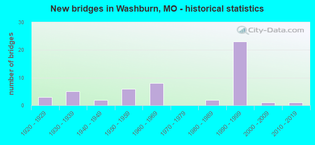
- New bridges - historical statistics
- 31920-1929
- 51930-1939
- 21940-1949
- 61950-1959
- 81960-1969
- 21980-1989
- 231990-1999
- 12000-2009
- 12010-2019

- Reconstructed bridges - Historical Statistics
- 11930-1939
- 01940-1949
- 01950-1959
- 11960-1969
- 11970-1979
- 21980-1989
- 11990-1999
- 62000-2009
- 12010-2019


- Bridge Condition - Deck
- 3.1%Excellent
- 15.6%Very good
- 43.8%Good
- 18.8%Satisfactory
- 9.4%Fair
- 6.3%Poor
- 3.1%Serious

- Bridge Condition - Superstructure
- 3.1%Excellent
- 6.3%Very good
- 53.1%Good
- 21.9%Satisfactory
- 9.4%Fair
- 3.1%Poor
- 3.1%Serious

- Bridge Condition - Substructure
- 3.1%Excellent
- 28.1%Very good
- 12.5%Good
- 37.5%Satisfactory
- 15.6%Fair
- 3.1%Poor

- Bridge Condition - Channel
- 4.7%Very good
- 7.0%Good
- 53.5%Satisfactory
- 30.2%Fair
- 4.7%Poor

- Bridge Condition - Culverts
- 26.3%Good
- 52.6%Satisfactory
- 21.1%Fair
Find on map >> Show street view
Structure Number: 2933, Location: S 24 T 53 N R 3 W (Lat: 39.352961, Lng: -91.194181), Route carried "on" structure: US 61, Year Built: 1996, Status: Open, Structure Length: 5.88m (19.29ft), Average Daily Traffic: 5,901 (year 2021), Truck Traffic: 39%, Average Future Daily Traffic: 11,212 (year 2041), Design Load: HS 20+Mod, Features Intersected: KCS RR
Minimum Vertical Clearance: 30+ m (98+ ft), Kilometerpoint: 145.324, Lanes on structure: 2, Base Highway Network: Yes, Owner: State Highway Agency, Approaching Roadway Width: 12.2m (40.0ft), Skew: 1 degrees, Material/Design: Prestressed concrete continuous, Design/Construction: Stringer/Multi-beam, Number Of Spans In Main Unit: 3, Length of Maximum Span: 19.7m (64.6ft), Curb or Sidewalk Widths: Left: 0.2m (0.7ft), Right: 0.2m (0.7ft), Curb-To-Curb Width: 11.8m (38.7ft), Out-to-Out Width: 12.6m (41.3ft)
Condition: Deck: Good, Superstructure: Good, Substructure: Excellent, Operating Rating: 90.0 metric tons, Method Used To Determine Operating Rating: Load Factor (LF), Inventory Rating: 54.0 metric tons, Method Used To Determine Inventory Rating: Load Factor (LF), Structural Evaluation: Better than present minimum criteria, Deck Geometry: Better than present minimum criteria, Underclear: Superior to present desirable criteria, Approach Roadway Alignment: Equal to present desirable criteria, Designated Inspection Frequency: Every 24 months, Inspection Date: December 2020, Deck Structure Type: Concrete Cast-file-Place, Wearing Surface/Protective System: Wearing Surface: Monolithic Concrete, Deck Protection: Epoxy Coated Reinforcing
Find on map >> Show street view
Structure Number: 31441, Location: S 13 T 22 N R 28 W (Lat: 36.620775, Lng: -93.920242), Route carried "on" structure: County highway 808, Year Built: 2005, Status: Open, Structure Length: 1.24m (4.07ft), Average Daily Traffic: 25 (year 2019), Truck Traffic: 10%, Average Future Daily Traffic: 43 (year 2039), Design Load: HS 20, Features Intersected: FLAT CR, Facility Carried by Structure: FARM RD 1085
Minimum Vertical Clearance: 30+ m (98+ ft), Kilometerpoint: 0.322, Lanes on structure: 2, Owner: County Highway Agency, Approaching Roadway Width: 5.5m (18.0ft), Skew: 2 degrees, Material/Design: Steel, Design/Construction: Stringer/Multi-beam, Number Of Spans In Main Unit: 1, Length of Maximum Span: 12.0m (39.4ft), Curb-To-Curb Width: 7.3m (24.0ft), Out-to-Out Width: 7.5m (24.6ft)
Condition: Deck: Good, Superstructure: Good, Substructure: Good, Channel: Satisfactory, Operating Rating: 66.6 metric tons, Method Used To Determine Operating Rating: Load Factor (LF), Inventory Rating: 39.6 metric tons, Method Used To Determine Inventory Rating: Load Factor (LF), Structural Evaluation: Better than present minimum criteria, Deck Geometry: Equal to present minimum criteria, Waterway Adequacy: Equal to present minimum criteria, Approach Roadway Alignment: Equal to present minimum criteria, Designated Inspection Frequency: Every 24 months, Inspection Date: Febuary 2022, Deck Structure Type: Concrete Cast-file-Place, Wearing Surface/Protective System: Wearing Surface: Monolithic Concrete
Find on map >> Show street view
Structure Number: 34143, Location: S 23 T 22 N R 28 W (Lat: 36.607778, Lng: -93.938611), Route carried "on" structure: County highway 914, Year Built: 2011, Status: Open, Structure Length: 1.15m (3.77ft), Average Daily Traffic: 30 (year 2019), Truck Traffic: 10%, Average Future Daily Traffic: 51 (year 2039), Features Intersected: FLAT CR, Facility Carried by Structure: FARM RD 2225
Minimum Vertical Clearance: 30+ m (98+ ft), Kilometerpoint: 0.000, Lanes on structure: 2, Owner: County Highway Agency, Approaching Roadway Width: 6.1m (20.0ft), Skew: 2 degrees, Material/Design: Steel, Design/Construction: Stringer/Multi-beam, Number Of Spans In Main Unit: 1, Length of Maximum Span: 10.7m (35.1ft), Curb-To-Curb Width: 7.1m (23.3ft), Out-to-Out Width: 7.2m (23.6ft)
Condition: Deck: Good, Superstructure: Good, Substructure: Very good, Channel: Satisfactory, Operating Rating: 45.0 metric tons, Method Used To Determine Operating Rating: Load Factor (LF), Inventory Rating: 27.0 metric tons, Method Used To Determine Inventory Rating: Load Factor (LF), Structural Evaluation: Equal to present minimum criteria, Deck Geometry: Somewhat better than minimum adequacy, Waterway Adequacy: Equal to present minimum criteria, Approach Roadway Alignment: Equal to present desirable criteria, Designated Inspection Frequency: Every 24 months, Inspection Date: Febuary 2022, Deck Structure Type: Concrete Cast-file-Place, Wearing Surface/Protective System: Wearing Surface: Monolithic Concrete
Find on map >> Show street view
Structure Number: 3688, Location: S 22 T 22 N R 28 W (Lat: 36.603300, Lng: -93.944189), Route carried "on" structure: State highway 37, Year Built: 1987, Status: Open, Structure Length: 1.23m (4.04ft), Average Daily Traffic: 6,011 (year 2021), Truck Traffic: 13%, Average Future Daily Traffic: 10,519 (year 2041), Design Load: HS 20, Features Intersected: FLAT CR
Minimum Vertical Clearance: 30+ m (98+ ft), Kilometerpoint: 112.109, Lanes on structure: 2, Base Highway Network: Yes, Owner: State Highway Agency, Approaching Roadway Width: 11.0m (36.1ft), Material/Design: Concrete continuous, Design/Construction: Culvert, Number Of Spans In Main Unit: 3, Length of Maximum Span: 4.0m (13.1ft)
Condition: Channel: Fair, Culverts: Good, Inventory Rating: 63.9 metric tons, Method Used To Determine Inventory Rating: Load Factor (LF), Structural Evaluation: Better than present minimum criteria, Waterway Adequacy: Superior to present desirable criteria, Approach Roadway Alignment: Equal to present desirable criteria, Designated Inspection Frequency: Every 24 months, Inspection Date: April 2020
Find on map >> Show street view
Structure Number: 3771, Location: S 28 T 48 N R 16 W (Lat: 38.899744, Lng: -92.668242), Route carried "on" structure: State highway 87, Year Built: 1990, Status: Open, Structure Length: 5.88m (19.29ft), Average Daily Traffic: 2,063 (year 2021), Truck Traffic: 16%, Average Future Daily Traffic: 3,198 (year 2041), Design Load: HS 20, Features Intersected: CLARKS FORK CR
Minimum Vertical Clearance: 30+ m (98+ ft), Kilometerpoint: 44.912, Lanes on structure: 2, Base Highway Network: Yes, Owner: State Highway Agency, Approaching Roadway Width: 10.4m (34.1ft), Skew: 2 degrees, Material/Design: Prestressed concrete continuous, Design/Construction: Tee Beam, Number Of Spans In Main Unit: 6, Length of Maximum Span: 10.9m (35.8ft), Curb or Sidewalk Widths: Left: 0.2m (0.7ft), Right: 0.2m (0.7ft), Curb-To-Curb Width: 10.0m (32.8ft), Out-to-Out Width: 10.8m (35.4ft)
Condition: Deck: Good, Superstructure: Good, Substructure: Fair, Channel: Satisfactory, Operating Rating: 69.3 metric tons, Method Used To Determine Operating Rating: Load Factor (LF), Inventory Rating: 41.4 metric tons, Method Used To Determine Inventory Rating: Load Factor (LF), Structural Evaluation: Somewhat better than minimum adequacy, Deck Geometry: Meets minimum limits, Waterway Adequacy: Equal to present desirable criteria, Approach Roadway Alignment: Equal to present desirable criteria, Designated Inspection Frequency: Every 24 months, Inspection Date: July 2021, Deck Structure Type: Concrete Cast-file-Place, Wearing Surface/Protective System: Wearing Surface: Monolithic Concrete, Deck Protection: Internally Sealed
Find on map >> Show street view
Structure Number: 3772, Location: S 24 T 62 N R 28 W (Lat: 40.148658, Lng: -93.998464), Route carried "on" structure: State highway H, Year Built: 1992, Status: Open, Structure Length: 5.06m (16.60ft), Average Daily Traffic: 444 (year 2021), Truck Traffic: 19%, Average Future Daily Traffic: 577 (year 2041), Design Load: HS 20, Features Intersected: CYPRESS CR
Minimum Vertical Clearance: 30+ m (98+ ft), Kilometerpoint: 3.434, Lanes on structure: 2, Owner: State Highway Agency, Approaching Roadway Width: 6.7m (22.0ft), Skew: 3 degrees, Material/Design: Prestressed concrete continuous, Design/Construction: Stringer/Multi-beam, Number Of Spans In Main Unit: 3, Length of Maximum Span: 17.0m (55.8ft), Curb or Sidewalk Widths: Left: 0.2m (0.7ft), Right: 0.2m (0.7ft), Curb-To-Curb Width: 8.8m (28.9ft), Out-to-Out Width: 9.6m (31.5ft)
Condition: Deck: Good, Superstructure: Good, Substructure: Satisfactory, Channel: Satisfactory, Operating Rating: 65.7 metric tons, Method Used To Determine Operating Rating: Load Factor (LF), Inventory Rating: 36.9 metric tons, Method Used To Determine Inventory Rating: Load Factor (LF), Structural Evaluation: Equal to present minimum criteria, Deck Geometry: Somewhat better than minimum adequacy, Waterway Adequacy: Superior to present desirable criteria, Approach Roadway Alignment: Equal to present desirable criteria, Designated Inspection Frequency: Every 24 months, Inspection Date: October 2021, Deck Structure Type: Concrete Cast-file-Place, Wearing Surface/Protective System: Wearing Surface: Monolithic Concrete, Deck Protection: Epoxy Coated Reinforcing
Find on map >> Show street view
Structure Number: 3775, Location: S 4 T 53 N R 20 W (Lat: 39.431025, Lng: -93.157772), Route carried "on" structure: US 24, Year Built: 1987, Status: Open, Structure Length: 66.75m (219.00ft), Average Daily Traffic: 1,651 (year 2021), Truck Traffic: 26%, Average Future Daily Traffic: 2,889 (year 2041), Design Load: HS 20+Mod, Features Intersected: GRAND RVR
Minimum Vertical Clearance: 30+ m (98+ ft), Kilometerpoint: 159.823, Lanes on structure: 2, Base Highway Network: Yes, Owner: State Highway Agency, Approaching Roadway Width: 13.0m (42.7ft), Material/Design: Steel continuous, Design/Construction: Stringer/Multi-beam, Number Of Spans In Main Unit: 3, Number Of Approach Spans: 31, Length of Maximum Span: 54.9m (180.1ft), Curb-To-Curb Width: 13.0m (42.7ft), Out-to-Out Width: 13.8m (45.3ft)
Condition: Deck: Good, Superstructure: Satisfactory, Substructure: Satisfactory, Channel: Poor, Operating Rating: 65.7 metric tons, Method Used To Determine Operating Rating: Load Factor (LF), Inventory Rating: 37.8 metric tons, Method Used To Determine Inventory Rating: Load Factor (LF), Structural Evaluation: Equal to present minimum criteria, Deck Geometry: Better than present minimum criteria, Waterway Adequacy: Equal to present desirable criteria, Approach Roadway Alignment: Equal to present desirable criteria, Designated Inspection Frequency: Every 24 months, Underwater Inspection Frequency: Every 60 months, Inspection Date: March 2020, Underwater Inspection Date: July 2018, Deck Structure Type: Concrete Cast-file-Place, Wearing Surface/Protective System: Wearing Surface: Monolithic Concrete, Deck Protection: Epoxy Coated Reinforcing
Find on map >> Show street view
Structure Number: 4327, Location: S 25 T 34 N R 31 W (Lat: 37.661392, Lng: -94.281197), Route carried "on" structure: State highway B, Year Built: 1995, Status: Open, Structure Length: 0.83m (2.72ft), Average Daily Traffic: 1,247 (year 2021), Truck Traffic: 12%, Average Future Daily Traffic: 1,746 (year 2041), Design Load: HS 20, Features Intersected: LIT CLEAR CR
Minimum Vertical Clearance: 30+ m (98+ ft), Kilometerpoint: 2.530, Lanes on structure: 2, Owner: State Highway Agency, Approaching Roadway Width: 11.0m (36.1ft), Material/Design: Concrete continuous, Design/Construction: Culvert, Number Of Spans In Main Unit: 2, Length of Maximum Span: 4.0m (13.1ft)
Condition: Channel: Satisfactory, Culverts: Good, Inventory Rating: 72.0 metric tons, Method Used To Determine Inventory Rating: Load Factor (LF), Structural Evaluation: Better than present minimum criteria, Waterway Adequacy: Equal to present desirable criteria, Approach Roadway Alignment: Equal to present desirable criteria, Designated Inspection Frequency: Every 24 months, Inspection Date: March 2022
Find on map >> Show street view
Structure Number: 4328, Location: S 4 T 63 N R 37 W (Lat: 40.303717, Lng: -95.065919), Route carried "on" structure: State highway 113, Year Built: 1994, Status: Open, Structure Length: 5.49m (18.01ft), Average Daily Traffic: 392 (year 2021), Truck Traffic: 11%, Average Future Daily Traffic: 510 (year 2041), Design Load: HS 20+Mod, Features Intersected: FLORIDA CR
Minimum Vertical Clearance: 30+ m (98+ ft), Kilometerpoint: 16.774, Lanes on structure: 2, Owner: State Highway Agency, Approaching Roadway Width: 11.0m (36.1ft), Material/Design: Prestressed concrete continuous, Design/Construction: Stringer/Multi-beam, Number Of Spans In Main Unit: 3, Length of Maximum Span: 20.4m (66.9ft), Curb or Sidewalk Widths: Left: 0.2m (0.7ft), Right: 0.2m (0.7ft), Curb-To-Curb Width: 10.6m (34.8ft), Out-to-Out Width: 11.5m (37.7ft)
Condition: Deck: Good, Superstructure: Good, Substructure: Satisfactory, Channel: Satisfactory, Operating Rating: 88.2 metric tons, Method Used To Determine Operating Rating: Load Factor (LF), Inventory Rating: 40.5 metric tons, Method Used To Determine Inventory Rating: Load Factor (LF), Structural Evaluation: Equal to present minimum criteria, Deck Geometry: Better than present minimum criteria, Waterway Adequacy: Superior to present desirable criteria, Approach Roadway Alignment: Equal to present desirable criteria, Designated Inspection Frequency: Every 24 months, Inspection Date: September 2021, Deck Structure Type: Concrete Cast-file-Place, Wearing Surface/Protective System: Wearing Surface: Monolithic Concrete, Deck Protection: Internally Sealed
Find on map >> Show street view
Structure Number: 4329, Location: S 8 T 23 N R 21 W (Lat: 36.711392, Lng: -93.220894), Route carried "on" structure: US 65, Year Built: 1995, Status: Open, Structure Length: 6.43m (21.10ft), Average Daily Traffic: 11,963 (year 2021), Truck Traffic: 7%, Average Future Daily Traffic: 20,935 (year 2041), Design Load: HS 20+Mod, Features Intersected: MO 76, RT F
Minimum Vertical Clearance: 30+ m (98+ ft), Kilometerpoint: 477.796, Lanes on structure: 2, Lanes under structure: 4, Base Highway Network: Yes, Owner: State Highway Agency, Approaching Roadway Width: 11.9m (39.0ft), Skew: 11 degrees, Material/Design: Steel continuous, Design/Construction: Stringer/Multi-beam, Number Of Spans In Main Unit: 3, Length of Maximum Span: 31.7m (104.0ft), Curb or Sidewalk Widths: Left: 0.2m (0.7ft), Right: 0.2m (0.7ft), Curb-To-Curb Width: 11.9m (39.0ft), Out-to-Out Width: 12.7m (41.7ft)
Condition: Deck: Satisfactory, Superstructure: Very good, Substructure: Very good, Operating Rating: 82.8 metric tons, Method Used To Determine Operating Rating: Load Factor (LF), Inventory Rating: 45.0 metric tons, Method Used To Determine Inventory Rating: Load Factor (LF), Structural Evaluation: Equal to present desirable criteria, Deck Geometry: Equal to present minimum criteria, Underclear: Meets minimum limits, Approach Roadway Alignment: Equal to present desirable criteria, Designated Inspection Frequency: Every 24 months, Inspection Date: June 2020, Deck Structure Type: Concrete Cast-file-Place, Wearing Surface/Protective System: Wearing Surface: Monolithic Concrete, Deck Protection: Epoxy Coated Reinforcing
Find on map >> Show street view
Structure Number: 433, Location: S 22 T 55 N R 26 W (Lat: 39.557658, Lng: -93.795869), Route carried "on" structure: State highway A, Year Built: 1959, Year Reconstructed: 2007, Status: Open, Structure Length: 4.48m (14.70ft), Average Daily Traffic: 383 (year 2021), Truck Traffic: 12%, Average Future Daily Traffic: 498 (year 2041), Design Load: H 15, Features Intersected: S FK MUD CR
Minimum Vertical Clearance: 30+ m (98+ ft), Kilometerpoint: 19.753, Lanes on structure: 2, Owner: State Highway Agency, Approaching Roadway Width: 6.1m (20.0ft), Skew: 2 degrees, Material/Design: Steel, Design/Construction: Stringer/Multi-beam, Number Of Spans In Main Unit: 3, Length of Maximum Span: 16.9m (55.4ft), Curb-To-Curb Width: 7.3m (24.0ft), Out-to-Out Width: 8.1m (26.6ft)
Condition: Deck: Very good, Superstructure: Satisfactory, Substructure: Good, Channel: Satisfactory, Operating Rating: 59.4 metric tons, Method Used To Determine Operating Rating: Load Factor (LF), Inventory Rating: 36.0 metric tons, Method Used To Determine Inventory Rating: Load Factor (LF), Structural Evaluation: Equal to present minimum criteria, Deck Geometry: Somewhat better than minimum adequacy, Waterway Adequacy: Equal to present desirable criteria, Approach Roadway Alignment: Equal to present desirable criteria, Designated Inspection Frequency: Every 24 months, Inspection Date: November 2020, Deck Structure Type: Concrete Cast-file-Place, Wearing Surface/Protective System: Wearing Surface: Monolithic Concrete, Deck Protection: Epoxy Coated Reinforcing
Find on map >> Show street view
Structure Number: 4331, Location: S 21 T 25 N R 32 W (Lat: 36.866042, Lng: -94.430661), Route carried "on" structure: Interstate 49, Year Built: 1996, Status: Open, Structure Length: 5.79m (19.00ft), Average Daily Traffic: 10,094 (year 2021), Truck Traffic: 30%, Average Future Daily Traffic: 18,674 (year 2041), Design Load: HS 25 or greater, Features Intersected: CRD MULBERRY RD
Minimum Vertical Clearance: 30+ m (98+ ft), Kilometerpoint: 253.746, Lanes on structure: 2, Lanes under structure: 2, Base Highway Network: Yes, Owner: State Highway Agency, Approaching Roadway Width: 12.2m (40.0ft), Skew: 1 degrees, Material/Design: Prestressed concrete continuous, Design/Construction: Stringer/Multi-beam, Number Of Spans In Main Unit: 3, Length of Maximum Span: 19.6m (64.3ft), Curb or Sidewalk Widths: Left: 0.2m (0.7ft), Right: 0.2m (0.7ft), Curb-To-Curb Width: 11.8m (38.7ft), Out-to-Out Width: 12.6m (41.3ft)
Condition: Deck: Good, Superstructure: Good, Substructure: Good, Operating Rating: 83.7 metric tons, Method Used To Determine Operating Rating: Load Factor (LF), Inventory Rating: 46.8 metric tons, Method Used To Determine Inventory Rating: Load Factor (LF), Structural Evaluation: Better than present minimum criteria, Deck Geometry: Equal to present minimum criteria, Underclear: Meets minimum limits, Approach Roadway Alignment: Equal to present desirable criteria, Designated Inspection Frequency: Every 24 months, Inspection Date: September 2021, Deck Structure Type: Concrete Cast-file-Place, Wearing Surface/Protective System: Wearing Surface: Epoxy Overlay, Deck Protection: Epoxy Coated Reinforcing
Find on map >> Show street view
Structure Number: 4334, Location: S 21 T 25 N R 32 W (Lat: 36.862272, Lng: -94.428281), Route carried "on" structure: Interstate 49, Year Built: 1996, Status: Open, Structure Length: 5.12m (16.80ft), Average Daily Traffic: 10,094 (year 2021), Truck Traffic: 30%, Average Future Daily Traffic: 18,674 (year 2041), Design Load: HS 25 or greater, Features Intersected: BNSF RR
Minimum Vertical Clearance: 30+ m (98+ ft), Kilometerpoint: 41.864, Lanes on structure: 2, Base Highway Network: Yes, Owner: State Highway Agency, Approaching Roadway Width: 12.2m (40.0ft), Skew: 2 degrees, Material/Design: Prestressed concrete continuous, Design/Construction: Stringer/Multi-beam, Number Of Spans In Main Unit: 3, Length of Maximum Span: 17.3m (56.8ft), Curb or Sidewalk Widths: Left: 0.2m (0.7ft), Right: 0.2m (0.7ft), Curb-To-Curb Width: 11.8m (38.7ft), Out-to-Out Width: 12.6m (41.3ft)
Condition: Deck: Good, Superstructure: Good, Substructure: Very good, Operating Rating: 81.9 metric tons, Method Used To Determine Operating Rating: Load Factor (LF), Inventory Rating: 46.8 metric tons, Method Used To Determine Inventory Rating: Load Factor (LF), Structural Evaluation: Better than present minimum criteria, Deck Geometry: Equal to present minimum criteria, Underclear: Better than present minimum criteria, Approach Roadway Alignment: Equal to present desirable criteria, Designated Inspection Frequency: Every 24 months, Inspection Date: September 2021, Deck Structure Type: Concrete Cast-file-Place, Wearing Surface/Protective System: Wearing Surface: Epoxy Overlay, Deck Protection: Epoxy Coated Reinforcing
Find on map >> Show street view
Structure Number: 436, Location: S 7 T 25 N R 10 E (Lat: 36.819217, Lng: -89.913411), Route carried "on" structure: US 60, Year Built: 1995, Status: Open, Structure Length: 1.43m (4.69ft), Average Daily Traffic: 7,027 (year 2021), Truck Traffic: 22%, Average Future Daily Traffic: 12,297 (year 2041), Design Load: HS 20, Features Intersected: LATERAL DRAIN DTCH
Minimum Vertical Clearance: 30+ m (98+ ft), Kilometerpoint: 475.264, Lanes on structure: 2, Base Highway Network: Yes, Owner: State Highway Agency, Approaching Roadway Width: 12.2m (40.0ft), Skew: 1 degrees, Material/Design: Concrete continuous, Design/Construction: Culvert, Number Of Spans In Main Unit: 3, Length of Maximum Span: 4.6m (15.1ft)
Condition: Channel: Poor, Culverts: Fair, Inventory Rating: 61.2 metric tons, Method Used To Determine Inventory Rating: Load Factor (LF), Structural Evaluation: Somewhat better than minimum adequacy, Waterway Adequacy: Equal to present desirable criteria, Approach Roadway Alignment: Equal to present desirable criteria, Designated Inspection Frequency: Every 24 months, Inspection Date: October 2021
Find on map >> Show street view
Structure Number: 4361, Location: S 8 T 25 N R 11 E (Lat: 36.822631, Lng: -89.879464), Route carried "on" structure: US 60, Year Built: 1995, Status: Open, Structure Length: 1.15m (3.77ft), Average Daily Traffic: 7,027 (year 2021), Truck Traffic: 22%, Average Future Daily Traffic: 12,297 (year 2041), Design Load: HS 20, Features Intersected: DRAIN DTCH #2
Minimum Vertical Clearance: 30+ m (98+ ft), Kilometerpoint: 478.319, Lanes on structure: 2, Base Highway Network: Yes, Owner: State Highway Agency, Approaching Roadway Width: 12.2m (40.0ft), Material/Design: Concrete continuous, Design/Construction: Culvert, Number Of Spans In Main Unit: 3, Length of Maximum Span: 3.7m (12.1ft)
Condition: Channel: Very good, Culverts: Good, Inventory Rating: 69.3 metric tons, Method Used To Determine Inventory Rating: Load Factor (LF), Structural Evaluation: Better than present minimum criteria, Waterway Adequacy: Equal to present desirable criteria, Approach Roadway Alignment: Equal to present desirable criteria, Designated Inspection Frequency: Every 24 months, Inspection Date: October 2021
Find on map >> Show street view
Structure Number: 4362, Location: S 10 T 25 N R 11 E (Lat: 36.825797, Lng: -89.847831), Route carried "on" structure: US 60, Year Built: 1995, Status: Open, Structure Length: 0.96m (3.15ft), Average Daily Traffic: 5,725 (year 2021), Truck Traffic: 21%, Average Future Daily Traffic: 10,019 (year 2041), Design Load: HS 20, Features Intersected: MAIN DTCH #7
Minimum Vertical Clearance: 30+ m (98+ ft), Kilometerpoint: 481.166, Lanes on structure: 2, Base Highway Network: Yes, Owner: State Highway Agency, Approaching Roadway Width: 12.2m (40.0ft), Material/Design: Concrete continuous, Design/Construction: Culvert, Number Of Spans In Main Unit: 2, Length of Maximum Span: 4.6m (15.1ft)
Condition: Channel: Very good, Culverts: Good, Operating Rating: 85.5 metric tons, Method Used To Determine Operating Rating: Load Factor (LF), Inventory Rating: 51.3 metric tons, Method Used To Determine Inventory Rating: Load Factor (LF), Structural Evaluation: Better than present minimum criteria, Waterway Adequacy: Equal to present desirable criteria, Approach Roadway Alignment: Equal to present desirable criteria, Designated Inspection Frequency: Every 24 months, Inspection Date: October 2021
Find on map >> Show street view
Structure Number: 4364, Location: S 12 T 25 N R 11 E (Lat: 36.831522, Lng: -89.790767), Route carried "on" structure: US 60, Year Built: 1995, Status: Open, Structure Length: 0.97m (3.18ft), Average Daily Traffic: 4,212 (year 2021), Truck Traffic: 21%, Average Future Daily Traffic: 7,371 (year 2041), Design Load: HS 20, Features Intersected: MAIN DTCH #5
Minimum Vertical Clearance: 30+ m (98+ ft), Kilometerpoint: 486.300, Lanes on structure: 2, Base Highway Network: Yes, Owner: State Highway Agency, Approaching Roadway Width: 12.2m (40.0ft), Skew: 1 degrees, Material/Design: Concrete continuous, Design/Construction: Culvert, Number Of Spans In Main Unit: 3, Length of Maximum Span: 3.0m (9.8ft)
Condition: Channel: Good, Culverts: Satisfactory, Operating Rating: 61.2 metric tons, Method Used To Determine Operating Rating: Load Factor (LF), Inventory Rating: 36.9 metric tons, Method Used To Determine Inventory Rating: Load Factor (LF), Structural Evaluation: Equal to present minimum criteria, Waterway Adequacy: Equal to present desirable criteria, Approach Roadway Alignment: Equal to present desirable criteria, Designated Inspection Frequency: Every 24 months, Inspection Date: October 2021
Find on map >> Show street view
Structure Number: 4366, Location: S 8 T 28 N R 22 W (Lat: 37.143861, Lng: -93.365306), Route carried "on" structure: State highway FF, Year Built: 1996, Status: Open, Structure Length: 0.67m (2.20ft), Average Daily Traffic: 15,826 (year 2021), Truck Traffic: 4%, Average Future Daily Traffic: 24,530 (year 2041), Design Load: HS 20, Features Intersected: DRY BR OF WILSON C
Minimum Vertical Clearance: 30+ m (98+ ft), Kilometerpoint: 1.081, Lanes on structure: 4, Base Highway Network: Yes, Owner: State Highway Agency, Approaching Roadway Width: 11.0m (36.1ft), Skew: 2 degrees, Material/Design: Concrete continuous, Design/Construction: Culvert, Number Of Spans In Main Unit: 2, Length of Maximum Span: 3.0m (9.8ft)
Condition: Channel: Fair, Culverts: Good, Structural Evaluation: Better than present minimum criteria, Waterway Adequacy: Equal to present desirable criteria, Approach Roadway Alignment: Equal to present desirable criteria, Designated Inspection Frequency: Every 24 months, Inspection Date: January 2021
Find on map >> Show street view
Structure Number: 4367, Location: S 24 T 28 N R 25 W (Lat: 37.121275, Lng: -93.611442), Route carried "on" structure: State highway 174, Year Built: 1995, Status: Open, Structure Length: 5.70m (18.70ft), Average Daily Traffic: 3,159 (year 2021), Truck Traffic: 7%, Average Future Daily Traffic: 4,581 (year 2041), Design Load: HS 20, Features Intersected: TURNBACK CR
Minimum Vertical Clearance: 30+ m (98+ ft), Kilometerpoint: 19.649, Lanes on structure: 2, Owner: State Highway Agency, Approaching Roadway Width: 7.9m (25.9ft), Material/Design: Prestressed concrete continuous, Design/Construction: Stringer/Multi-beam, Number Of Spans In Main Unit: 3, Length of Maximum Span: 19.1m (62.7ft), Curb or Sidewalk Widths: Left: 0.2m (0.7ft), Right: 0.2m (0.7ft), Curb-To-Curb Width: 11.8m (38.7ft), Out-to-Out Width: 12.6m (41.3ft)
Condition: Deck: Very good, Superstructure: Good, Substructure: Very good, Channel: Satisfactory, Operating Rating: 73.8 metric tons, Method Used To Determine Operating Rating: Load Factor (LF), Inventory Rating: 36.0 metric tons, Method Used To Determine Inventory Rating: Load Factor (LF), Structural Evaluation: Better than present minimum criteria, Deck Geometry: Somewhat better than minimum adequacy, Waterway Adequacy: Equal to present desirable criteria, Approach Roadway Alignment: Equal to present desirable criteria, Designated Inspection Frequency: Every 24 months, Inspection Date: July 2020, Deck Structure Type: Concrete Cast-file-Place, Wearing Surface/Protective System: Wearing Surface: Monolithic Concrete, Deck Protection: Epoxy Coated Reinforcing
Find on map >> Show street view
Structure Number: 4369, Location: S 12 T 25 N R 10 E (Lat: 36.818125, Lng: -89.924508), Route carried "on" structure: US 60, Year Built: 1995, Status: Open, Structure Length: 7.92m (25.98ft), Average Daily Traffic: 7,027 (year 2021), Truck Traffic: 22%, Average Future Daily Traffic: 12,297 (year 2041), Design Load: HS 25 or greater, Features Intersected: UP RR
Minimum Vertical Clearance: 30+ m (98+ ft), Kilometerpoint: 474.234, Lanes on structure: 2, Base Highway Network: Yes, Owner: State Highway Agency, Approaching Roadway Width: 12.2m (40.0ft), Skew: 4 degrees, Material/Design: Prestressed concrete continuous, Design/Construction: Stringer/Multi-beam, Number Of Spans In Main Unit: 3, Length of Maximum Span: 26.5m (86.9ft), Curb or Sidewalk Widths: Left: 0.0m, Right: 0.2m (0.7ft), Curb-To-Curb Width: 11.8m (38.7ft), Out-to-Out Width: 12.6m (41.3ft)
Condition: Deck: Good, Superstructure: Excellent, Substructure: Very good, Operating Rating: 84.6 metric tons, Method Used To Determine Operating Rating: Load Factor (LF), Inventory Rating: 42.3 metric tons, Method Used To Determine Inventory Rating: Load Factor (LF), Structural Evaluation: Equal to present desirable criteria, Deck Geometry: Equal to present minimum criteria, Underclear: Superior to present desirable criteria, Approach Roadway Alignment: Equal to present desirable criteria, Designated Inspection Frequency: Every 24 months, Inspection Date: October 2021, Deck Structure Type: Concrete Cast-file-Place, Wearing Surface/Protective System: Wearing Surface: Monolithic Concrete, Deck Protection: Internally Sealed
Find on map >> Show street view
Structure Number: 437, Location: S 893 T 42 N R 6 E (Lat: 38.350372, Lng: -90.407989), Route carried "on" structure: State highway M, Year Built: 1996, Status: Open, Structure Length: 21.46m (70.41ft), Average Daily Traffic: 8,808 (year 2021), Truck Traffic: 5%, Average Future Daily Traffic: 14,974 (year 2041), Design Load: HS 20+Mod, Features Intersected: GLAIZE CR
Minimum Vertical Clearance: 30+ m (98+ ft), Kilometerpoint: 2.057, Lanes on structure: 2, Base Highway Network: Yes, Owner: State Highway Agency, Approaching Roadway Width: 12.2m (40.0ft), Material/Design: Prestressed concrete continuous, Design/Construction: Stringer/Multi-beam, Number Of Spans In Main Unit: 11, Length of Maximum Span: 27.7m (90.9ft), Curb or Sidewalk Widths: Left: 0.2m (0.7ft), Right: 0.2m (0.7ft), Curb-To-Curb Width: 11.8m (38.7ft), Out-to-Out Width: 12.6m (41.3ft)
Condition: Deck: Satisfactory, Superstructure: Good, Substructure: Satisfactory, Channel: Satisfactory, Operating Rating: 89.1 metric tons, Method Used To Determine Operating Rating: Load Factor (LF), Inventory Rating: 53.1 metric tons, Method Used To Determine Inventory Rating: Load Factor (LF), Structural Evaluation: Equal to present minimum criteria, Deck Geometry: Better than present minimum criteria, Waterway Adequacy: Equal to present desirable criteria, Approach Roadway Alignment: Equal to present desirable criteria, Designated Inspection Frequency: Every 24 months, Inspection Date: November 2020, Deck Structure Type: Concrete Cast-file-Place, Wearing Surface/Protective System: Wearing Surface: Monolithic Concrete, Deck Protection: Internally Sealed
Find on map >> Show street view
Structure Number: 4372, Location: S 22 T 63 N R 12 W (Lat: 40.258167, Lng: -92.216658), Route carried "on" structure: State highway 15, Year Built: 1997, Status: Open, Structure Length: 0.88m (2.89ft), Average Daily Traffic: 1,150 (year 2021), Truck Traffic: 14%, Average Future Daily Traffic: 1,783 (year 2041), Design Load: HS 20, Features Intersected: TRIB TO BRIDGE CR
Minimum Vertical Clearance: 30+ m (98+ ft), Kilometerpoint: 42.113, Lanes on structure: 2, Base Highway Network: Yes, Owner: State Highway Agency, Approaching Roadway Width: 11.0m (36.1ft), Material/Design: Concrete continuous, Design/Construction: Culvert, Number Of Spans In Main Unit: 2, Length of Maximum Span: 4.3m (14.1ft), Curb-To-Curb Width: 20.7m (67.9ft), Out-to-Out Width: 21.3m (69.9ft)
Condition: Channel: Satisfactory, Culverts: Satisfactory, Inventory Rating: 78.3 metric tons, Method Used To Determine Inventory Rating: Load Factor (LF), Structural Evaluation: Equal to present minimum criteria, Deck Geometry: Superior to present desirable criteria, Waterway Adequacy: Equal to present desirable criteria, Approach Roadway Alignment: Equal to present desirable criteria, Designated Inspection Frequency: Every 24 months, Inspection Date: November 2021
Find on map >> Show street view
Structure Number: 4373, Location: S 4 T 61 N R 16 W (Lat: 40.123686, Lng: -92.693983), Route carried "on" structure: State highway 11, Year Built: 1995, Status: Open, Structure Length: 11.37m (37.30ft), Average Daily Traffic: 528 (year 2021), Truck Traffic: 6%, Average Future Daily Traffic: 660 (year 2041), Design Load: HS 20, Features Intersected: CHARITON RVR
Minimum Vertical Clearance: 30+ m (98+ ft), Kilometerpoint: 53.331, Lanes on structure: 2, Owner: State Highway Agency, Approaching Roadway Width: 11.0m (36.1ft), Material/Design: Prestressed concrete continuous, Design/Construction: Tee Beam, Number Of Spans In Main Unit: 3, Length of Maximum Span: 37.9m (124.3ft), Curb or Sidewalk Widths: Left: 0.2m (0.7ft), Right: 0.2m (0.7ft), Curb-To-Curb Width: 10.6m (34.8ft), Out-to-Out Width: 11.4m (37.4ft)
Condition: Deck: Very good, Superstructure: Good, Substructure: Very good, Channel: Satisfactory, Operating Rating: 89.1 metric tons, Method Used To Determine Operating Rating: Allowable Stress (AS), Inventory Rating: 39.6 metric tons, Method Used To Determine Inventory Rating: Allowable Stress (AS), Structural Evaluation: Better than present minimum criteria, Deck Geometry: Equal to present minimum criteria, Waterway Adequacy: Superior to present desirable criteria, Approach Roadway Alignment: Equal to present desirable criteria, Designated Inspection Frequency: Every 24 months, Inspection Date: December 2021, Deck Structure Type: Concrete Cast-file-Place, Wearing Surface/Protective System: Wearing Surface: Monolithic Concrete, Deck Protection: Epoxy Coated Reinforcing
Find on map >> Show street view
Structure Number: 4374, Location: S 20 T 31 N R 21 W (Lat: 37.401908, Lng: -93.272311), Route carried "on" structure: State highway H, Year Built: 1997, Status: Open, Structure Length: 3.57m (11.71ft), Average Daily Traffic: 2,381 (year 2021), Truck Traffic: 11%, Average Future Daily Traffic: 3,810 (year 2041), Design Load: HS 20, Features Intersected: N DRY SAC RVR
Minimum Vertical Clearance: 30+ m (98+ ft), Kilometerpoint: 24.877, Lanes on structure: 2, Owner: State Highway Agency, Approaching Roadway Width: 8.5m (27.9ft), Material/Design: Prestressed concrete continuous, Design/Construction: Stringer/Multi-beam, Number Of Spans In Main Unit: 3, Length of Maximum Span: 15.2m (49.9ft), Curb-To-Curb Width: 11.8m (38.7ft), Out-to-Out Width: 12.4m (40.7ft)
Condition: Deck: Good, Superstructure: Good, Substructure: Very good, Channel: Fair, Operating Rating: 83.7 metric tons, Method Used To Determine Operating Rating: Load Factor (LF), Inventory Rating: 50.4 metric tons, Method Used To Determine Inventory Rating: Load Factor (LF), Structural Evaluation: Better than present minimum criteria, Deck Geometry: Somewhat better than minimum adequacy, Waterway Adequacy: Superior to present desirable criteria, Approach Roadway Alignment: Equal to present desirable criteria, Designated Inspection Frequency: Every 24 months, Inspection Date: July 2020, Deck Structure Type: Concrete Cast-file-Place, Wearing Surface/Protective System: Wearing Surface: Monolithic Concrete, Deck Protection: Epoxy Coated Reinforcing
Find on map >> Show street view
Structure Number: 4375, Location: S 8 T 35 N R 1 W (Lat: 37.767328, Lng: -91.072392), Route carried "on" structure: State highway C, Year Built: 1995, Status: Open, Structure Length: 13.93m (45.70ft), Average Daily Traffic: 398 (year 2021), Truck Traffic: 11%, Average Future Daily Traffic: 557 (year 2041), Design Load: HS 20, Features Intersected: COURTOIS CR
Minimum Vertical Clearance: 30+ m (98+ ft), Kilometerpoint: 2.197, Lanes on structure: 2, Owner: State Highway Agency, Approaching Roadway Width: 9.1m (29.9ft), Skew: 3 degrees, Material/Design: Prestressed concrete continuous, Design/Construction: Stringer/Multi-beam, Number Of Spans In Main Unit: 7, Length of Maximum Span: 20.1m (65.9ft), Curb or Sidewalk Widths: Left: 0.0m, Right: 0.2m (0.7ft), Curb-To-Curb Width: 8.8m (28.9ft), Out-to-Out Width: 9.6m (31.5ft)
Condition: Deck: Very good, Superstructure: Good, Substructure: Very good, Channel: Satisfactory, Operating Rating: 81.0 metric tons, Method Used To Determine Operating Rating: Load Factor (LF), Inventory Rating: 48.6 metric tons, Method Used To Determine Inventory Rating: Load Factor (LF), Structural Evaluation: Better than present minimum criteria, Deck Geometry: Equal to present minimum criteria, Waterway Adequacy: Equal to present desirable criteria, Approach Roadway Alignment: Better than present minimum criteria, Designated Inspection Frequency: Every 24 months, Inspection Date: September 2020, Deck Structure Type: Concrete Cast-file-Place, Wearing Surface/Protective System: Wearing Surface: Monolithic Concrete, Deck Protection: Epoxy Coated Reinforcing
Find on map >> Show street view
Structure Number: 4376, Location: S 1 T 25 N R 12 E (Lat: 36.838478, Lng: -89.712803), Route carried "on" structure: US 60, Year Built: 1995, Status: Open, Structure Length: 0.76m (2.49ft), Average Daily Traffic: 4,597 (year 2021), Truck Traffic: 21%, Average Future Daily Traffic: 8,045 (year 2041), Design Load: HS 20, Features Intersected: DRAIN DTCH #37
Minimum Vertical Clearance: 30+ m (98+ ft), Kilometerpoint: 493.307, Lanes on structure: 2, Base Highway Network: Yes, Owner: State Highway Agency, Approaching Roadway Width: 12.2m (40.0ft), Material/Design: Concrete continuous, Design/Construction: Culvert, Number Of Spans In Main Unit: 2, Length of Maximum Span: 3.7m (12.1ft)
Condition: Channel: Good, Culverts: Satisfactory, Operating Rating: 87.3 metric tons, Method Used To Determine Operating Rating: Field evaluation and documented engineering judgment, Inventory Rating: 52.2 metric tons, Method Used To Determine Inventory Rating: Field evaluation and documented engineering judgment, Structural Evaluation: Equal to present minimum criteria, Waterway Adequacy: Equal to present desirable criteria, Approach Roadway Alignment: Equal to present desirable criteria, Designated Inspection Frequency: Every 24 months, Inspection Date: October 2021
Find on map >> Show street view
Structure Number: 4377, Location: S 2 T 25 N R 12 E (Lat: 36.837647, Lng: -89.730222), Route carried "on" structure: US 60, Year Built: 1995, Status: Open, Structure Length: 8.53m (27.99ft), Average Daily Traffic: 6,929 (year 2021), Truck Traffic: 21%, Average Future Daily Traffic: 12,126 (year 2041), Design Load: HS 25 or greater, Features Intersected: WAHITE DRAIN DTCH
Minimum Vertical Clearance: 30+ m (98+ ft), Kilometerpoint: 491.707, Lanes on structure: 2, Base Highway Network: Yes, Owner: State Highway Agency, Approaching Roadway Width: 12.2m (40.0ft), Material/Design: Prestressed concrete continuous, Design/Construction: Stringer/Multi-beam, Number Of Spans In Main Unit: 3, Length of Maximum Span: 28.5m (93.5ft), Curb or Sidewalk Widths: Left: 0.2m (0.7ft), Right: 0.2m (0.7ft), Curb-To-Curb Width: 11.8m (38.7ft), Out-to-Out Width: 12.6m (41.3ft)
Condition: Deck: Very good, Superstructure: Very good, Substructure: Very good, Channel: Satisfactory, Operating Rating: 96.3 metric tons, Method Used To Determine Operating Rating: Load Factor (LF), Inventory Rating: 45.9 metric tons, Method Used To Determine Inventory Rating: Load Factor (LF), Structural Evaluation: Equal to present desirable criteria, Deck Geometry: Better than present minimum criteria, Waterway Adequacy: Equal to present desirable criteria, Approach Roadway Alignment: Equal to present desirable criteria, Designated Inspection Frequency: Every 24 months, Inspection Date: October 2021, Deck Structure Type: Concrete Cast-file-Place, Wearing Surface/Protective System: Wearing Surface: Monolithic Concrete, Deck Protection: Internally Sealed
Find on map >> Show street view
Structure Number: 4395, Location: S 893 T 42 N R 6 E (Lat: 38.366833, Lng: -90.483833), Route carried "on" structure: State highway M, Year Built: 1996, Status: Open, Structure Length: 0.68m (2.23ft), Average Daily Traffic: 10,232 (year 2021), Truck Traffic: 10%, Average Future Daily Traffic: 17,394 (year 2041), Design Load: HS 20, Features Intersected: BR OF GLAIZE CR
Minimum Vertical Clearance: 30+ m (98+ ft), Kilometerpoint: 2.556, Lanes on structure: 6, Base Highway Network: Yes, Owner: State Highway Agency, Approaching Roadway Width: 12.2m (40.0ft), Skew: 2 degrees, Material/Design: Concrete continuous, Design/Construction: Culvert, Number Of Spans In Main Unit: 2, Length of Maximum Span: 3.0m (9.8ft)
Condition: Channel: Satisfactory, Culverts: Satisfactory, Structural Evaluation: Equal to present minimum criteria, Waterway Adequacy: Equal to present desirable criteria, Approach Roadway Alignment: Equal to present desirable criteria, Designated Inspection Frequency: Every 24 months, Inspection Date: December 2020
Find on map >> Show street view
Structure Number: 4446, Location: S 14 T 63 N R 29 W (Lat: 40.252139, Lng: -94.138981), Route carried "on" structure: US 136, Year Built: 1965, Year Reconstructed: 2009, Status: Open, Structure Length: 3.69m (12.11ft), Average Daily Traffic: 2,382 (year 2021), Truck Traffic: 14%, Average Future Daily Traffic: 5,002 (year 2041), Design Load: H 20, Features Intersected: WHITE OAK CR
Minimum Vertical Clearance: 30+ m (98+ ft), Kilometerpoint: 157.774, Lanes on structure: 2, Base Highway Network: Yes, Owner: State Highway Agency, Approaching Roadway Width: 7.3m (24.0ft), Skew: 1 degrees, Material/Design: Steel continuous, Design/Construction: Stringer/Multi-beam, Number Of Spans In Main Unit: 3, Length of Maximum Span: 14.0m (45.9ft), Curb-To-Curb Width: 9.8m (32.2ft), Out-to-Out Width: 10.6m (34.8ft)
Condition: Deck: Satisfactory, Superstructure: Good, Substructure: Satisfactory, Channel: Fair, Operating Rating: 42.3 metric tons, Method Used To Determine Operating Rating: Load Factor (LF), Inventory Rating: 25.2 metric tons, Method Used To Determine Inventory Rating: Load Factor (LF), Structural Evaluation: Equal to present minimum criteria, Deck Geometry: Meets minimum limits, Waterway Adequacy: Equal to present minimum criteria, Approach Roadway Alignment: Equal to present desirable criteria, Designated Inspection Frequency: Every 24 months, Inspection Date: October 2021, Deck Structure Type: Concrete Cast-file-Place, Wearing Surface/Protective System: Wearing Surface: Monolithic Concrete, Deck Protection: Epoxy Coated Reinforcing
Find on map >> Show street view
Structure Number: 4471, Location: S 35 T 24 N R 8 W (Lat: 36.706033, Lng: -91.817817), Route carried "on" structure: US 63, Year Built: 1952, Status: Open, Structure Length: 5.73m (18.80ft), Average Daily Traffic: 8,284 (year 2021), Truck Traffic: 20%, Average Future Daily Traffic: 15,740 (year 2041), Design Load: H 15, Features Intersected: MUSTION CR
Minimum Vertical Clearance: 30+ m (98+ ft), Kilometerpoint: 504.205, Lanes on structure: 2, Base Highway Network: Yes, Owner: State Highway Agency, Approaching Roadway Width: 13.4m (44.0ft), Skew: 4 degrees, Material/Design: Concrete, Design/Construction: Tee Beam, Number Of Spans In Main Unit: 5, Length of Maximum Span: 11.4m (37.4ft), Curb-To-Curb Width: 9.0m (29.5ft), Out-to-Out Width: 9.2m (30.2ft)
Condition: Deck: Satisfactory, Superstructure: Satisfactory, Substructure: Satisfactory, Channel: Fair, Operating Rating: 43.2 metric tons, Method Used To Determine Operating Rating: Load Factor (LF), Inventory Rating: 26.1 metric tons, Method Used To Determine Inventory Rating: Load Factor (LF), Structural Evaluation: Equal to present minimum criteria, Deck Geometry: High priority of replacement, Waterway Adequacy: Equal to present desirable criteria, Approach Roadway Alignment: Equal to present desirable criteria, Length Of Structure Improvement: 0.68m (2.23ft), Designated Inspection Frequency: Every 24 months, Inspection Date: December 2020, Bridge Improvement Cost: $637,000, Roadway Improvement Cost: $64,000, Total Project Cost: $955,000 ( Estimate for 2022), Deck Structure Type: Concrete Cast-file-Place, Wearing Surface/Protective System: Wearing Surface: Bituminous, Membrane: Built-up
Find on map >> Show street view
Structure Number: 4472, Location: S 14 T 23 N R 7 W (Lat: 36.660872, Lng: -91.713753), Route carried "on" structure: US 63, Year Built: 1955, Year Reconstructed: 2007, Status: Open, Structure Length: 5.76m (18.90ft), Average Daily Traffic: 7,489 (year 2021), Truck Traffic: 22%, Average Future Daily Traffic: 14,229 (year 2041), Design Load: H 20, Features Intersected: BNSF RR
Minimum Vertical Clearance: 30+ m (98+ ft), Kilometerpoint: 515.471, Lanes on structure: 2, Base Highway Network: Yes, Owner: State Highway Agency, Approaching Roadway Width: 13.4m (44.0ft), Skew: 4 degrees, Material/Design: Steel, Design/Construction: Stringer/Multi-beam, Number Of Spans In Main Unit: 5, Length of Maximum Span: 18.5m (60.7ft), Curb-To-Curb Width: 8.5m (27.9ft), Out-to-Out Width: 8.7m (28.5ft)
Condition: Deck: Poor, Superstructure: Fair, Substructure: Fair, Operating Rating: 34.2 metric tons, Method Used To Determine Operating Rating: Load Factor (LF), Inventory Rating: 20.7 metric tons, Method Used To Determine Inventory Rating: Load Factor (LF), Structural Evaluation: Somewhat better than minimum adequacy, Deck Geometry: High priority of replacement, Underclear: Somewhat better than minimum adequacy, Approach Roadway Alignment: Equal to present minimum criteria, Length Of Structure Improvement: 0.68m (2.23ft), Designated Inspection Frequency: Every 12 months, Inspection Date: December 2021, Bridge Improvement Cost: $936,000, Roadway Improvement Cost: $94,000, Total Project Cost: $1,405,000 ( Estimate for 2022), Deck Structure Type: Concrete Cast-file-Place, Wearing Surface/Protective System: Wearing Surface: Bituminous, Membrane: Built-up
Find on map >> Show street view
Structure Number: 4499, Location: S 27 T 23 N R 5 E (Lat: 36.607931, Lng: -90.520439), Route carried "on" structure: US 67, Year Built: 1922, Year Reconstructed: 1941, Status: Open, Structure Length: 1.65m (5.41ft), Average Daily Traffic: 7,193 (year 2021), Truck Traffic: 27%, Average Future Daily Traffic: 12,588 (year 2041), Design Load: H 15, Features Intersected: HARVIELL DRAIN DTC
Minimum Vertical Clearance: 30+ m (98+ ft), Kilometerpoint: 304.266, Lanes on structure: 2, Base Highway Network: Yes, Owner: State Highway Agency, Approaching Roadway Width: 7.3m (24.0ft), Skew: 4 degrees, Material/Design: Steel, Design/Construction: Stringer/Multi-beam, Number Of Spans In Main Unit: 1, Length of Maximum Span: 16.5m (54.1ft), Curb-To-Curb Width: 7.9m (25.9ft), Out-to-Out Width: 8.8m (28.9ft)
Condition: Deck: Fair, Superstructure: Fair, Substructure: Fair, Channel: Fair, Operating Rating: 31.5 metric tons, Method Used To Determine Operating Rating: Load Factor (LF), Inventory Rating: 18.9 metric tons, Method Used To Determine Inventory Rating: Load Factor (LF), Structural Evaluation: Meets minimum limits, Deck Geometry: High priority of replacement, Waterway Adequacy: Equal to present minimum criteria, Approach Roadway Alignment: Equal to present desirable criteria, Length Of Structure Improvement: 0.23m (0.75ft), Designated Inspection Frequency: Every 24 months, Inspection Date: Febuary 2021, Bridge Improvement Cost: $315,000, Roadway Improvement Cost: $31,000, Total Project Cost: $472,000 ( Estimate for 2022), Deck Structure Type: Concrete Cast-file-Place, Wearing Surface/Protective System: Wearing Surface: Bituminous
Find on map >> Show street view
Structure Number: 4516, Location: S 35 T 65 N R 6 W (Lat: 40.387436, Lng: -91.514967), Route carried "on" structure: US 136, Year Built: 1968, Status: Open, Structure Length: 2.65m (8.69ft), Average Daily Traffic: 2,372 (year 2021), Truck Traffic: 25%, Average Future Daily Traffic: 3,677 (year 2041), Design Load: H 20, Features Intersected: DRAIN DTCH
Minimum Vertical Clearance: 30+ m (98+ ft), Kilometerpoint: 405.702, Lanes on structure: 2, Base Highway Network: Yes, Owner: State Highway Agency, Approaching Roadway Width: 13.4m (44.0ft), Skew: 3 degrees, Material/Design: Concrete continuous, Design/Construction: Slab, Number Of Spans In Main Unit: 3, Length of Maximum Span: 13.7m (44.9ft), Curb-To-Curb Width: 13.4m (44.0ft), Out-to-Out Width: 14.0m (45.9ft)
Condition: Deck: Poor, Superstructure: Poor, Substructure: Satisfactory, Channel: Good, Operating Rating: 37.8 metric tons, Method Used To Determine Operating Rating: Allowable Stress (AS), Inventory Rating: 18.0 metric tons, Method Used To Determine Inventory Rating: Allowable Stress (AS), Structural Evaluation: Meets minimum limits, Deck Geometry: Better than present minimum criteria, Waterway Adequacy: Equal to present desirable criteria, Approach Roadway Alignment: Equal to present desirable criteria, Length Of Structure Improvement: 0.36m (1.18ft), Designated Inspection Frequency: Every 24 months, Inspection Date: November 2021, Bridge Improvement Cost: $453,000, Roadway Improvement Cost: $45,000, Total Project Cost: $680,000 ( Estimate for 2022), Deck Structure Type: Concrete Cast-file-Place, Wearing Surface/Protective System: Wearing Surface: Bituminous, Membrane: Built-up
Find on map >> Show street view
Structure Number: 4517, Location: S 8 T 16 N R 7 E (Lat: 36.039167, Lng: -90.322989), Route carried "on" structure: US 412, Year Built: 1968, Year Reconstructed: 1990, Status: Open, Structure Length: 2.59m (8.50ft), Average Daily Traffic: 7,831 (year 2021), Truck Traffic: 16%, Average Future Daily Traffic: 13,704 (year 2041), Design Load: H 20, Features Intersected: RED DEVIL DTCH
Minimum Vertical Clearance: 30+ m (98+ ft), Kilometerpoint: 1.989, Lanes on structure: 2, Base Highway Network: Yes, Owner: State Highway Agency, Approaching Roadway Width: 11.0m (36.1ft), Material/Design: Concrete continuous, Design/Construction: Slab, Number Of Spans In Main Unit: 2, Length of Maximum Span: 12.5m (41.0ft), Curb-To-Curb Width: 12.2m (40.0ft), Out-to-Out Width: 13.0m (42.7ft)
Condition: Deck: Good, Superstructure: Good, Substructure: Good, Channel: Satisfactory, Operating Rating: 47.7 metric tons, Method Used To Determine Operating Rating: Load Factor (LF), Inventory Rating: 28.8 metric tons, Method Used To Determine Inventory Rating: Load Factor (LF), Structural Evaluation: Better than present minimum criteria, Deck Geometry: Somewhat better than minimum adequacy, Waterway Adequacy: Equal to present desirable criteria, Approach Roadway Alignment: Equal to present desirable criteria, Designated Inspection Frequency: Every 24 months, Inspection Date: November 2020, Deck Structure Type: Concrete Cast-file-Place, Wearing Surface/Protective System: Wearing Surface: Low Slump Concrete, Membrane: Built-up
Find on map >> Show street view
Structure Number: 4518, Location: S 6 T 18 N R 10 E (Lat: 36.236689, Lng: -90.022650), Route carried "on" structure: US 412, Year Built: 1959, Status: Open, Structure Length: 6.04m (19.82ft), Average Daily Traffic: 6,450 (year 2021), Truck Traffic: 29%, Average Future Daily Traffic: 11,288 (year 2041), Design Load: H 20, Features Intersected: DRAIN DTCH NO 19
Minimum Vertical Clearance: 30+ m (98+ ft), Kilometerpoint: 42.410, Lanes on structure: 2, Base Highway Network: Yes, Owner: State Highway Agency, Approaching Roadway Width: 13.4m (44.0ft), Skew: 3 degrees, Material/Design: Concrete continuous, Design/Construction: Slab, Number Of Spans In Main Unit: 5, Length of Maximum Span: 13.1m (43.0ft), Curb-To-Curb Width: 9.4m (30.8ft), Out-to-Out Width: 9.6m (31.5ft)
Condition: Deck: Satisfactory, Superstructure: Satisfactory, Substructure: Satisfactory, Channel: Fair, Operating Rating: 55.8 metric tons, Method Used To Determine Operating Rating: Load Factor (LF), Inventory Rating: 33.3 metric tons, Method Used To Determine Inventory Rating: Load Factor (LF), Structural Evaluation: Equal to present minimum criteria, Deck Geometry: Meets minimum limits, Waterway Adequacy: Equal to present desirable criteria, Approach Roadway Alignment: Equal to present desirable criteria, Designated Inspection Frequency: Every 24 months, Inspection Date: November 2020, Deck Structure Type: Concrete Cast-file-Place, Wearing Surface/Protective System: Wearing Surface: Epoxy Overlay, Membrane: Built-up, Deck Protection: Cathodic Protection
Find on map >> Show street view
Structure Number: 4935, Location: S 28 T 48 N R 9 W (Lat: 38.901089, Lng: -91.942897), Route carried "on" structure: US 54, Year Built: 1963, Year Reconstructed: 2017, Status: Open, Structure Length: 6.64m (21.78ft), Average Daily Traffic: 8,623 (year 2021), Truck Traffic: 21%, Average Future Daily Traffic: 15,953 (year 2041), Design Load: HS 20, Features Intersected: RICHLAND CR
Minimum Vertical Clearance: 30+ m (98+ ft), Kilometerpoint: 314.267, Lanes on structure: 2, Base Highway Network: Yes, Owner: State Highway Agency, Approaching Roadway Width: 13.4m (44.0ft), Material/Design: Steel continuous, Design/Construction: Stringer/Multi-beam, Number Of Spans In Main Unit: 3, Length of Maximum Span: 25.9m (85.0ft), Curb-To-Curb Width: 9.1m (29.9ft), Out-to-Out Width: 10.0m (32.8ft)
Condition: Deck: Excellent, Superstructure: Good, Substructure: Satisfactory, Channel: Satisfactory, Operating Rating: 48.6 metric tons, Method Used To Determine Operating Rating: Load Factor (LF), Inventory Rating: 29.7 metric tons, Method Used To Determine Inventory Rating: Load Factor (LF), Structural Evaluation: Equal to present minimum criteria, Deck Geometry: Meets minimum limits, Waterway Adequacy: Equal to present desirable criteria, Approach Roadway Alignment: Equal to present desirable criteria, Designated Inspection Frequency: Every 24 months, Inspection Date: October 2020, Deck Structure Type: Concrete Cast-file-Place, Wearing Surface/Protective System: Wearing Surface: Bituminous
Find on map >> Show street view
Structure Number: 5256, Location: S 19 T 36 N R 20 W (Lat: 37.853994, Lng: -93.175283), Route carried "on" structure: US 65, Year Built: 1930, Year Reconstructed: 1993, Status: Open, Structure Length: 0.70m (2.30ft), Average Daily Traffic: 4,641 (year 2021), Truck Traffic: 11%, Average Future Daily Traffic: 8,122 (year 2041), Design Load: H 15, Features Intersected: CAHOOCHIE CR
Minimum Vertical Clearance: 30+ m (98+ ft), Kilometerpoint: 345.052, Lanes on structure: 2, Base Highway Network: Yes, Owner: State Highway Agency, Approaching Roadway Width: 11.0m (36.1ft), Skew: 2 degrees, Material/Design: Concrete continuous, Design/Construction: Culvert, Number Of Spans In Main Unit: 2, Length of Maximum Span: 3.0m (9.8ft)
Condition: Channel: Satisfactory, Culverts: Satisfactory, Operating Rating: 49.5 metric tons, Method Used To Determine Operating Rating: Load Factor (LF), Inventory Rating: 29.7 metric tons, Method Used To Determine Inventory Rating: Load Factor (LF), Structural Evaluation: Equal to present minimum criteria, Waterway Adequacy: Equal to present desirable criteria, Approach Roadway Alignment: Equal to present desirable criteria, Designated Inspection Frequency: Every 24 months, Inspection Date: November 2021
Find on map >> Show street view
Structure Number: 5257, Location: S 32 T 36 N R 8 W (Lat: 37.790789, Lng: -91.828350), Route carried "on" structure: US 63, Year Built: 1967, Year Reconstructed: 2007, Status: Open, Structure Length: 10.45m (34.28ft), Average Daily Traffic: 6,060 (year 2021), Truck Traffic: 12%, Average Future Daily Traffic: 11,514 (year 2041), Design Load: H 20, Features Intersected: LIT PINEY CR
Minimum Vertical Clearance: 30+ m (98+ ft), Kilometerpoint: 361.247, Lanes on structure: 2, Base Highway Network: Yes, Owner: State Highway Agency, Approaching Roadway Width: 12.2m (40.0ft), Material/Design: Steel continuous, Design/Construction: Stringer/Multi-beam, Number Of Spans In Main Unit: 4, Length of Maximum Span: 29.6m (97.1ft), Curb-To-Curb Width: 9.8m (32.2ft), Out-to-Out Width: 10.6m (34.8ft)
Condition: Deck: Fair, Superstructure: Satisfactory, Substructure: Satisfactory, Channel: Satisfactory, Operating Rating: 42.3 metric tons, Method Used To Determine Operating Rating: Load Factor (LF), Inventory Rating: 25.2 metric tons, Method Used To Determine Inventory Rating: Load Factor (LF), Structural Evaluation: Equal to present minimum criteria, Deck Geometry: Meets minimum limits, Waterway Adequacy: Equal to present desirable criteria, Approach Roadway Alignment: Equal to present desirable criteria, Designated Inspection Frequency: Every 24 months, Inspection Date: May 2021, Deck Structure Type: Concrete Cast-file-Place, Wearing Surface/Protective System: Wearing Surface: Bituminous, Membrane: Built-up
Find on map >> Show street view
Structure Number: 5273, Location: S 17 T 37 N R 2 E (Lat: 37.931883, Lng: -90.843183), Route carried "on" structure: State highway 8, Year Built: 1930, Status: Open, Structure Length: 0.90m (2.95ft), Average Daily Traffic: 3,705 (year 2021), Truck Traffic: 15%, Average Future Daily Traffic: 7,040 (year 2041), Design Load: H 15, Features Intersected: DRAIN DTCH
Minimum Vertical Clearance: 30+ m (98+ ft), Kilometerpoint: 80.683, Lanes on structure: 2, Base Highway Network: Yes, Owner: State Highway Agency, Approaching Roadway Width: 9.1m (29.9ft), Skew: 4 degrees, Material/Design: Concrete continuous, Design/Construction: Culvert, Number Of Spans In Main Unit: 2, Length of Maximum Span: 3.0m (9.8ft), Curb-To-Curb Width: 9.8m (32.2ft), Out-to-Out Width: 10.4m (34.1ft)
Condition: Channel: Fair, Culverts: Fair, Operating Rating: 49.5 metric tons, Method Used To Determine Operating Rating: Load Factor (LF), Inventory Rating: 29.7 metric tons, Method Used To Determine Inventory Rating: Load Factor (LF), Structural Evaluation: Somewhat better than minimum adequacy, Deck Geometry: Meets minimum limits, Waterway Adequacy: Equal to present desirable criteria, Approach Roadway Alignment: Equal to present desirable criteria, Designated Inspection Frequency: Every 24 months, Inspection Date: September 2020
Find on map >> Show street view
Structure Number: 5274, Location: S 3 T 51 N R 25 W (Lat: 39.263911, Lng: -93.691786), Route carried "on" structure: State highway 10, Year Built: 1929, Year Reconstructed: 1966, Status: Open, Structure Length: 1.71m (5.61ft), Average Daily Traffic: 1,774 (year 2021), Truck Traffic: 10%, Average Future Daily Traffic: 3,105 (year 2041), Design Load: H 20, Features Intersected: DRAIN DTCH
Minimum Vertical Clearance: 30+ m (98+ ft), Kilometerpoint: 55.275, Lanes on structure: 2, Base Highway Network: Yes, Owner: State Highway Agency, Approaching Roadway Width: 9.4m (30.8ft), Material/Design: Concrete, Design/Construction: Slab, Number Of Spans In Main Unit: 3, Length of Maximum Span: 7.9m (25.9ft), Curb-To-Curb Width: 9.8m (32.2ft), Out-to-Out Width: 10.5m (34.4ft)
Condition: Deck: Fair, Superstructure: Fair, Substructure: Fair, Channel: Satisfactory, Operating Rating: 31.5 metric tons, Method Used To Determine Operating Rating: Load Factor (LF), Inventory Rating: 18.9 metric tons, Method Used To Determine Inventory Rating: Load Factor (LF), Structural Evaluation: Somewhat better than minimum adequacy, Deck Geometry: Somewhat better than minimum adequacy, Waterway Adequacy: Equal to present desirable criteria, Approach Roadway Alignment: Equal to present desirable criteria, Designated Inspection Frequency: Every 24 months, Inspection Date: October 2020, Deck Structure Type: Concrete Cast-file-Place, Wearing Surface/Protective System: Wearing Surface: Bituminous
Find on map >> Show street view
Structure Number: 5275, Location: S 31 T 62 N R 9 W (Lat: 40.126767, Lng: -91.944719), Route carried "on" structure: State highway 6, Year Built: 1930, Status: Open, Structure Length: 1.08m (3.54ft), Average Daily Traffic: 2,586 (year 2021), Truck Traffic: 21%, Average Future Daily Traffic: 4,913 (year 2041), Design Load: H 15, Features Intersected: LIT TROUBLESOME CR
Minimum Vertical Clearance: 30+ m (98+ ft), Kilometerpoint: 290.030, Lanes on structure: 2, Base Highway Network: Yes, Owner: State Highway Agency, Approaching Roadway Width: 9.8m (32.2ft), Skew: 2 degrees, Material/Design: Concrete continuous, Design/Construction: Culvert, Number Of Spans In Main Unit: 3, Length of Maximum Span: 3.0m (9.8ft), Curb-To-Curb Width: 11.6m (38.1ft), Out-to-Out Width: 12.5m (41.0ft)
Condition: Channel: Satisfactory, Culverts: Satisfactory, Operating Rating: 67.5 metric tons, Method Used To Determine Operating Rating: Load Factor (LF), Inventory Rating: 40.5 metric tons, Method Used To Determine Inventory Rating: Load Factor (LF), Structural Evaluation: Equal to present minimum criteria, Deck Geometry: Somewhat better than minimum adequacy, Waterway Adequacy: Equal to present minimum criteria, Approach Roadway Alignment: Equal to present minimum criteria, Designated Inspection Frequency: Every 24 months, Inspection Date: October 2020
Find on map >> Show street view
Structure Number: 5292, Location: S 30 T 60 N R 20 W (Lat: 39.992258, Lng: -93.183636), Route carried "on" structure: State highway 5, Year Built: 1929, Year Reconstructed: 1977, Status: Open, Structure Length: 1.31m (4.30ft), Average Daily Traffic: 934 (year 2021), Truck Traffic: 14%, Average Future Daily Traffic: 1,214 (year 2041), Design Load: H 20, Features Intersected: BR OF LOCUST CR
Minimum Vertical Clearance: 30+ m (98+ ft), Kilometerpoint: 75.054, Lanes on structure: 2, Base Highway Network: Yes, Owner: State Highway Agency, Approaching Roadway Width: 7.3m (24.0ft), Skew: 2 degrees, Material/Design: Concrete, Design/Construction: Slab, Number Of Spans In Main Unit: 3, Length of Maximum Span: 4.4m (14.4ft), Curb-To-Curb Width: 8.5m (27.9ft), Out-to-Out Width: 9.4m (30.8ft)
Condition: Deck: Satisfactory, Superstructure: Satisfactory, Substructure: Fair, Channel: Fair, Operating Rating: 35.1 metric tons, Method Used To Determine Operating Rating: Load Factor (LF), Inventory Rating: 20.7 metric tons, Method Used To Determine Inventory Rating: Load Factor (LF), Structural Evaluation: Somewhat better than minimum adequacy, Deck Geometry: Somewhat better than minimum adequacy, Waterway Adequacy: Equal to present desirable criteria, Approach Roadway Alignment: Equal to present desirable criteria, Designated Inspection Frequency: Every 24 months, Inspection Date: September 2020, Deck Structure Type: Concrete Cast-file-Place, Wearing Surface/Protective System: Wearing Surface: Bituminous, Membrane: Built-up
Find on map >> Show street view
Structure Number: 5293, Location: S 3 T 46 N R 5 W (Lat: 38.776636, Lng: -91.467536), Route carried "on" structure: State highway 19, Year Built: 1930, Status: Open, Structure Length: 1.27m (4.17ft), Average Daily Traffic: 3,796 (year 2021), Truck Traffic: 11%, Average Future Daily Traffic: 5,884 (year 2041), Design Load: H 15, Features Intersected: SCHOOLHOUN CR
Minimum Vertical Clearance: 30+ m (98+ ft), Kilometerpoint: 109.848, Lanes on structure: 2, Base Highway Network: Yes, Owner: State Highway Agency, Approaching Roadway Width: 9.1m (29.9ft), Skew: 4 degrees, Material/Design: Concrete continuous, Design/Construction: Culvert, Number Of Spans In Main Unit: 3, Length of Maximum Span: 3.0m (9.8ft), Curb-To-Curb Width: 10.4m (34.1ft), Out-to-Out Width: 11.0m (36.1ft)
Condition: Channel: Fair, Culverts: Satisfactory, Operating Rating: 73.8 metric tons, Method Used To Determine Operating Rating: Load Factor (LF), Inventory Rating: 44.1 metric tons, Method Used To Determine Inventory Rating: Load Factor (LF), Structural Evaluation: Equal to present minimum criteria, Deck Geometry: Somewhat better than minimum adequacy, Waterway Adequacy: Equal to present minimum criteria, Approach Roadway Alignment: Equal to present desirable criteria, Designated Inspection Frequency: Every 24 months, Inspection Date: September 2020