Bridge Statistics for Wellington, Kansas (KS)
Condition, Traffic, Stress, Structural Evaluation, Project Costs
- New bridges - historical statistics
- 51920-1929
- 81930-1939
- 11940-1949
- 211950-1959
- 111960-1969
- 71970-1979
- 171980-1989
- 221990-1999
- 82000-2009
- 82010-2019
- 22020-2022

- Reconstructed bridges - Historical Statistics
- 11920-1929
- 01930-1939
- 01940-1949
- 01950-1959
- 31960-1969
- 51970-1979
- 31980-1989
- 11990-1999
- Bridge Condition - Deck
- 12.5%Very good
- 53.1%Good
- 25.0%Satisfactory
- 7.8%Fair
- 1.6%Poor
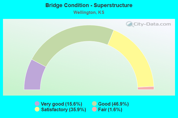
- Bridge Condition - Superstructure
- 15.6%Very good
- 46.9%Good
- 35.9%Satisfactory
- 1.6%Fair
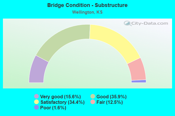
- Bridge Condition - Substructure
- 15.6%Very good
- 35.9%Good
- 34.4%Satisfactory
- 12.5%Fair
- 1.6%Poor
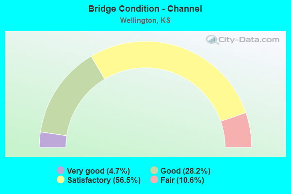
- Bridge Condition - Channel
- 4.7%Very good
- 28.2%Good
- 56.5%Satisfactory
- 10.6%Fair
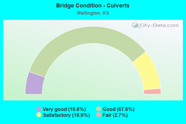
- Bridge Condition - Culverts
- 10.8%Very good
- 67.6%Good
- 18.9%Satisfactory
- 2.7%Fair
Find on map >> Show street view
Structure Number: 999903500961383, Location: .17 MI N OF US 160 (Lat: 37.278056, Lng: -97.340000), Route carried "on" structure: Ramp State highway 3, Year Built: 1988, Status: Open, Structure Length: 6.13m (20.11ft), Average Daily Traffic: 2,175 (year 2020), Truck Traffic: 5%, Average Future Daily Traffic: 16,197 (year 2041), Design Load: HS 20+Mod, Features Intersected: I35 KTA HWY, Facility Carried by Structure: OVER IC RAMP
Minimum Vertical Clearance: 30.47m (99.97ft), Kilometerpoint: 0.615, Lanes on structure: 2, Lanes under structure: 5, Owner: State Toll Authority, Approaching Roadway Width: 14.9m (48.9ft), Skew: 20 degrees, Material/Design: Prestressed concrete continuous, Design/Construction: Stringer/Multi-beam, Number Of Spans In Main Unit: 3, Length of Maximum Span: 34.1m (111.9ft), Curb-To-Curb Width: 11.7m (38.4ft), Out-to-Out Width: 12.5m (41.0ft)
Condition: Deck: Good, Superstructure: Good, Substructure: Good, Operating Rating: 50.3 metric tons, Method Used To Determine Operating Rating: Load Factor (LF), Inventory Rating: 30.2 metric tons, Method Used To Determine Inventory Rating: Load Factor (LF), Structural Evaluation: Better than present minimum criteria, Deck Geometry: Superior to present desirable criteria, Underclear: High priority of corrective action, Approach Roadway Alignment: Meets minimum limits, Length Of Structure Improvement: 20.10m (65.94ft), Designated Inspection Frequency: Every 24 months, Inspection Date: July 2021, Deck Structure Type: Concrete Cast-file-Place, Wearing Surface/Protective System: Wearing Surface: Monolithic Concrete
Find on map >> Show street view
Structure Number: 999903500961563, Location: 12.10 MI N US-166 (Lat: 37.232222, Lng: -97.338611), Route carried "on" structure: County highway 1342, Year Built: 2019, Status: Open, Structure Length: 8.13m (26.67ft), Average Daily Traffic: 136 (year 2020), Truck Traffic: 4%, Average Future Daily Traffic: 13,225 (year 2041), Design Load: HL 93, Features Intersected: I-35 Hwy (KTA)
Minimum Vertical Clearance: 30.47m (99.97ft), Kilometerpoint: 0.995, Lanes on structure: 2, Lanes under structure: 4, Owner: State Toll Authority, Approaching Roadway Width: 8.5m (27.9ft), Material/Design: Prestressed concrete continuous, Design/Construction: Stringer/Multi-beam, Number Of Spans In Main Unit: 4, Length of Maximum Span: 0.0m, Curb-To-Curb Width: 8.5m (27.9ft), Out-to-Out Width: 9.1m (29.9ft)
Condition: Deck: Very good, Superstructure: Very good, Substructure: Very good, Operating Rating: 53.5 metric tons, Method Used To Determine Operating Rating: Load and Resistance Factor Rating (LRFR) rating reported by rating factor(RF) method using HL-93 loadings, Inventory Rating: 33.4 metric tons, Method Used To Determine Inventory Rating: Load and Resistance Factor Rating (LRFR) rating reported by rating factor(RF) method using HL-93 loadings, Structural Evaluation: Equal to present desirable criteria, Deck Geometry: Equal to present minimum criteria, Underclear: Somewhat better than minimum adequacy, Approach Roadway Alignment: Meets minimum limits, Designated Inspection Frequency: Every 24 months, Inspection Date: July 2021, Wearing Surface/Protective System: Wearing Surface: Monolithic Concrete, Deck Protection: Epoxy Coated Reinforcing
Find on map >> Show street view
Structure Number: 999903500961573, Location: 13.12 MI N US-166 (Lat: 37.246667, Lng: -97.338611), Route carried "on" structure: ServiceCounty highway 111, Year Built: 2019, Status: Open, Structure Length: 7.67m (25.16ft), Average Daily Traffic: 22 (year 2020), Average Future Daily Traffic: 13,225 (year 2041), Design Load: HL 93, Features Intersected: I-35 Hwy (KTA), Facility Carried by Structure: Local Rd (30th St)
Minimum Vertical Clearance: 30.47m (99.97ft), Kilometerpoint: 15.965, Lanes on structure: 2, Lanes under structure: 4, Owner: State Toll Authority, Approaching Roadway Width: 6.1m (20.0ft), Material/Design: Prestressed concrete continuous, Design/Construction: Stringer/Multi-beam, Number Of Spans In Main Unit: 4, Length of Maximum Span: 0.0m, Curb-To-Curb Width: 8.5m (27.9ft), Out-to-Out Width: 9.1m (29.9ft)
Condition: Deck: Very good, Superstructure: Very good, Substructure: Very good, Operating Rating: 52.2 metric tons, Method Used To Determine Operating Rating: Load and Resistance Factor Rating (LRFR) rating reported by rating factor(RF) method using HL-93 loadings, Inventory Rating: 37.3 metric tons, Method Used To Determine Inventory Rating: Load and Resistance Factor Rating (LRFR) rating reported by rating factor(RF) method using HL-93 loadings, Structural Evaluation: Equal to present desirable criteria, Deck Geometry: Better than present minimum criteria, Underclear: Somewhat better than minimum adequacy, Approach Roadway Alignment: Better than present minimum criteria, Designated Inspection Frequency: Every 24 months, Inspection Date: July 2021, Wearing Surface/Protective System: Wearing Surface: Monolithic Concrete, Deck Protection: Epoxy Coated Reinforcing
Find on map >> Show street view
Structure Number: 999908100960481, Location: 1.50 MI S SJCT US160 (Lat: 37.250000, Lng: -97.403333), Route carried "on" structure: US 81, Year Built: 1950, Status: Open, Structure Length: 9.00m (29.53ft), Average Daily Traffic: 2,818 (year 2020), Truck Traffic: 20%, Average Future Daily Traffic: 3,721 (year 2041), Design Load: H 20, Features Intersected: SLATE CREEK
Minimum Vertical Clearance: 30.47m (99.97ft), Kilometerpoint: 44.827, Lanes on structure: 2, Owner: State Highway Agency, Approaching Roadway Width: 9.1m (29.9ft), Material/Design: Concrete continuous, Design/Construction: Tee Beam, Number Of Spans In Main Unit: 5, Length of Maximum Span: 20.1m (65.9ft), Curb-To-Curb Width: 7.9m (25.9ft), Out-to-Out Width: 8.3m (27.2ft)
Condition: Deck: Good, Superstructure: Satisfactory, Substructure: Good, Channel: Good, Operating Rating: 54.4 metric tons, Method Used To Determine Operating Rating: Load Factor (LF), Inventory Rating: 32.7 metric tons, Method Used To Determine Inventory Rating: Load Factor (LF), Structural Evaluation: Equal to present minimum criteria, Deck Geometry: High priority of corrective action, Waterway Adequacy: Equal to present minimum criteria, Approach Roadway Alignment: Meets minimum limits, Length Of Structure Improvement: 29.53m (96.88ft), Designated Inspection Frequency: Every 24 months, Inspection Date: December 2021, Deck Structure Type: Concrete Cast-file-Place, Wearing Surface/Protective System: Wearing Surface: Low Slump Concrete
Find on map >> Show street view
Structure Number: 999908100961431, Location: 8.54 MI N NJCT US-160 (Lat: 37.391111, Lng: -97.377500), Route carried "on" structure: US 81, Year Built: 2001, Status: Open, Structure Length: 1.12m (3.67ft), Average Daily Traffic: 3,690 (year 2020), Truck Traffic: 16%, Average Future Daily Traffic: 4,503 (year 2041), Design Load: HS 20+Mod, Features Intersected: NINNESCAH RIVER DRAINAGE
Minimum Vertical Clearance: 30.47m (99.97ft), Kilometerpoint: 62.200, Lanes on structure: 2, Base Highway Network: Yes, Owner: State Highway Agency, Approaching Roadway Width: 13.4m (44.0ft), Material/Design: Concrete, Design/Construction: Culvert, Number Of Spans In Main Unit: 2, Length of Maximum Span: 5.5m (18.0ft), Curb-To-Curb Width: 13.4m (44.0ft), Out-to-Out Width: 27.4m (89.9ft)
Condition: Channel: Very good, Culverts: Good, Operating Rating: 83.5 metric tons, Method Used To Determine Operating Rating: Load Factor (LF), Inventory Rating: 49.9 metric tons, Method Used To Determine Inventory Rating: Load Factor (LF), Structural Evaluation: Better than present minimum criteria, Deck Geometry: Better than present minimum criteria, Waterway Adequacy: Equal to present desirable criteria, Approach Roadway Alignment: Somewhat better than minimum adequacy, Length Of Structure Improvement: 3.67m (12.04ft), Designated Inspection Frequency: Every 24 months, Inspection Date: September 2021, Deck Structure Type: Concrete Cast-file-Place, Wearing Surface/Protective System: Wearing Surface: Bituminous
Find on map >> Show street view
Structure Number: 999916000960621, Location: 2.27 MI E K271 (Lat: 37.269444, Lng: -97.508611), Route carried "on" structure: US 160, Year Built: 1958, Status: Open, Structure Length: 1.14m (3.74ft), Average Daily Traffic: 3,089 (year 2020), Truck Traffic: 12%, Average Future Daily Traffic: 3,413 (year 2041), Design Load: H 20, Features Intersected: E BRANCH PRAIRIE CR
Minimum Vertical Clearance: 30.47m (99.97ft), Kilometerpoint: 26.765, Lanes on structure: 2, Base Highway Network: Yes, Owner: State Highway Agency, Approaching Roadway Width: 9.1m (29.9ft), Material/Design: Concrete, Design/Construction: Culvert, Number Of Spans In Main Unit: 3, Length of Maximum Span: 3.7m (12.1ft), Curb-To-Curb Width: 13.4m (44.0ft), Out-to-Out Width: 13.9m (45.6ft)
Condition: Channel: Good, Culverts: Good, Operating Rating: 31.1 metric tons, Method Used To Determine Operating Rating: Load Factor (LF), Inventory Rating: 18.7 metric tons, Method Used To Determine Inventory Rating: Load Factor (LF), Structural Evaluation: Somewhat better than minimum adequacy, Deck Geometry: Better than present minimum criteria, Waterway Adequacy: Equal to present desirable criteria, Approach Roadway Alignment: Better than present minimum criteria, Length Of Structure Improvement: 3.75m (12.30ft), Designated Inspection Frequency: Every 24 months, Inspection Date: October 2021, Deck Structure Type: Concrete Cast-file-Place, Wearing Surface/Protective System: Wearing Surface: Bituminous
Find on map >> Show street view
Structure Number: 999916000960631, Location: 6.84 MI E K271 (Lat: 37.266667, Lng: -97.427222), Route carried "on" structure: US 160, Year Built: 1929, Year Reconstructed: 1968, Status: Open, Structure Length: 1.86m (6.10ft), Average Daily Traffic: 3,089 (year 2020), Truck Traffic: 12%, Average Future Daily Traffic: 3,413 (year 2041), Design Load: H 15, Features Intersected: SLATE CREEK DRAINAGE
Minimum Vertical Clearance: 30.47m (99.97ft), Kilometerpoint: 34.123, Lanes on structure: 2, Base Highway Network: Yes, Owner: State Highway Agency, Approaching Roadway Width: 13.4m (44.0ft), Material/Design: Concrete, Design/Construction: Culvert, Number Of Spans In Main Unit: 7, Length of Maximum Span: 2.4m (7.9ft), Curb-To-Curb Width: 13.4m (44.0ft), Out-to-Out Width: 24.3m (79.7ft)
Condition: Channel: Good, Culverts: Good, Operating Rating: 42.4 metric tons, Method Used To Determine Operating Rating: Load Factor (LF), Inventory Rating: 25.3 metric tons, Method Used To Determine Inventory Rating: Load Factor (LF), Structural Evaluation: Equal to present minimum criteria, Deck Geometry: Better than present minimum criteria, Waterway Adequacy: Somewhat better than minimum adequacy, Approach Roadway Alignment: Equal to present desirable criteria, Length Of Structure Improvement: 6.09m (19.98ft), Designated Inspection Frequency: Every 24 months, Inspection Date: October 2021, Deck Structure Type: Concrete Cast-file-Place, Wearing Surface/Protective System: Wearing Surface: Bituminous
Find on map >> Show street view
Structure Number: 999916000960641, Location: 7.10 MI E K271 (Lat: 37.266944, Lng: -97.422222), Route carried "on" structure: US 160, Year Built: 1968, Status: Open, Structure Length: 11.42m (37.47ft), Average Daily Traffic: 3,089 (year 2020), Truck Traffic: 12%, Average Future Daily Traffic: 3,413 (year 2041), Design Load: HS 20, Features Intersected: SLATE CREEK
Minimum Vertical Clearance: 30.47m (99.97ft), Kilometerpoint: 34.543, Lanes on structure: 2, Base Highway Network: Yes, Owner: State Highway Agency, Approaching Roadway Width: 13.4m (44.0ft), Material/Design: Concrete continuous, Design/Construction: Tee Beam, Number Of Spans In Main Unit: 5, Length of Maximum Span: 25.6m (84.0ft), Curb-To-Curb Width: 13.4m (44.0ft), Out-to-Out Width: 14.0m (45.9ft)
Condition: Deck: Good, Superstructure: Satisfactory, Substructure: Good, Channel: Good, Operating Rating: 53.1 metric tons, Method Used To Determine Operating Rating: Load Factor (LF), Inventory Rating: 33.6 metric tons, Method Used To Determine Inventory Rating: Load Factor (LF), Structural Evaluation: Equal to present minimum criteria, Deck Geometry: Better than present minimum criteria, Waterway Adequacy: Equal to present minimum criteria, Approach Roadway Alignment: Equal to present desirable criteria, Length Of Structure Improvement: 37.45m (122.87ft), Designated Inspection Frequency: Every 24 months, Inspection Date: October 2021, Deck Structure Type: Concrete Cast-file-Place, Wearing Surface/Protective System: Wearing Surface: Low Slump Concrete
Find on map >> Show street view
Structure Number: 999916000960661, Location: 0.30 MI E EJCT US81 (Lat: 37.275000, Lng: -97.388611), Route carried "on" structure: US 160, Year Built: 1933, Year Reconstructed: 1965, Status: Open, Structure Length: 2.97m (9.74ft), Average Daily Traffic: 9,577 (year 2020), Truck Traffic: 4%, Average Future Daily Traffic: 14,513 (year 2041), Design Load: H 15, Features Intersected: HARGIS CREEK
Minimum Vertical Clearance: 30.47m (99.97ft), Kilometerpoint: 38.212, Lanes on structure: 4, Owner: State Highway Agency, Approaching Roadway Width: 15.8m (51.8ft), Material/Design: Concrete, Design/Construction: Tee Beam, Number Of Spans In Main Unit: 3, Length of Maximum Span: 9.1m (29.9ft), Curb or Sidewalk Widths: Left: 0.9m (3.0ft), Right: 0.9m (3.0ft), Curb-To-Curb Width: 15.8m (51.8ft), Out-to-Out Width: 19.4m (63.6ft)
Condition: Deck: Good, Superstructure: Satisfactory, Substructure: Satisfactory, Channel: Good, Operating Rating: 42.6 metric tons, Method Used To Determine Operating Rating: Load Factor (LF), Inventory Rating: 25.4 metric tons, Method Used To Determine Inventory Rating: Load Factor (LF), Structural Evaluation: Equal to present minimum criteria, Deck Geometry: Meets minimum limits, Waterway Adequacy: Better than present minimum criteria, Approach Roadway Alignment: Meets minimum limits, Length Of Structure Improvement: 9.75m (31.99ft), Designated Inspection Frequency: Every 24 months, Inspection Date: October 2021, Deck Structure Type: Concrete Cast-file-Place, Wearing Surface/Protective System: Wearing Surface: Monolithic Concrete
Find on map >> Show street view
Structure Number: 999916000960671, Location: 1.63 MI E EJCT US81 (Lat: 37.275000, Lng: -97.364444), Route carried "on" structure: US 160, Year Built: 1966, Status: Open, Structure Length: 1.14m (3.74ft), Average Daily Traffic: 5,784 (year 2020), Truck Traffic: 9%, Average Future Daily Traffic: 8,765 (year 2041), Design Load: H 20, Features Intersected: BEAVER CREEK
Minimum Vertical Clearance: 30.47m (99.97ft), Kilometerpoint: 40.366, Lanes on structure: 2, Owner: State Highway Agency, Approaching Roadway Width: 13.4m (44.0ft), Material/Design: Concrete, Design/Construction: Culvert, Number Of Spans In Main Unit: 3, Length of Maximum Span: 3.7m (12.1ft), Curb-To-Curb Width: 13.4m (44.0ft), Out-to-Out Width: 21.2m (69.6ft)
Condition: Channel: Good, Culverts: Good, Operating Rating: 54.2 metric tons, Method Used To Determine Operating Rating: Load Factor (LF), Inventory Rating: 32.5 metric tons, Method Used To Determine Inventory Rating: Load Factor (LF), Structural Evaluation: Better than present minimum criteria, Deck Geometry: Equal to present minimum criteria, Waterway Adequacy: Better than present minimum criteria, Approach Roadway Alignment: Equal to present desirable criteria, Length Of Structure Improvement: 3.75m (12.30ft), Designated Inspection Frequency: Every 24 months, Inspection Date: October 2021, Deck Structure Type: Concrete Cast-file-Place, Wearing Surface/Protective System: Wearing Surface: Bituminous
Find on map >> Show street view
Structure Number: 999916000960681, Location: 1.73 MI E EJ US81, SDRD N (Lat: 37.275278, Lng: -97.362778), Route carried "on" structure: ServiceCounty highway 751, Year Built: 1925, Year Reconstructed: 1933, Status: Open, Structure Length: 1.09m (3.58ft), Average Daily Traffic: 160 (year 2020), Truck Traffic: 1%, Average Future Daily Traffic: 9,335 (year 2041), Design Load: H 15, Features Intersected: BEAVER CREEK DRAINAGE, Facility Carried by Structure: OLD U160 ALIGN LT
Minimum Vertical Clearance: 30.47m (99.97ft), Kilometerpoint: 0.151, Lanes on structure: 2, Owner: State Highway Agency, Approaching Roadway Width: 7.3m (24.0ft), Material/Design: Concrete, Design/Construction: Culvert, Number Of Spans In Main Unit: 4, Length of Maximum Span: 2.4m (7.9ft), Curb-To-Curb Width: 11.7m (38.4ft), Out-to-Out Width: 12.3m (40.4ft)
Condition: Channel: Fair, Culverts: Good, Operating Rating: 24.0 metric tons, Method Used To Determine Operating Rating: Load Factor (LF), Inventory Rating: 14.3 metric tons, Method Used To Determine Inventory Rating: Load Factor (LF), Structural Evaluation: Meets minimum limits, Deck Geometry: Superior to present desirable criteria, Waterway Adequacy: Better than present minimum criteria, Approach Roadway Alignment: Somewhat better than minimum adequacy, Length Of Structure Improvement: 3.57m (11.71ft), Designated Inspection Frequency: Every 24 months, Inspection Date: October 2021, Deck Structure Type: Concrete Cast-file-Place, Wearing Surface/Protective System: Wearing Surface: Bituminous
Find on map >> Show street view
Structure Number: 999916000960691, Location: 2.01 MI E EJCT US81 (Lat: 37.275000, Lng: -97.357500), Route carried "on" structure: US 160, Year Built: 1966, Status: Open, Structure Length: 5.62m (18.44ft), Average Daily Traffic: 5,784 (year 2020), Truck Traffic: 9%, Average Future Daily Traffic: 8,765 (year 2041), Design Load: H 20, Features Intersected: BNSF RAILWAY
Minimum Vertical Clearance: 30.47m (99.97ft), Kilometerpoint: 40.977, Lanes on structure: 2, Owner: State Highway Agency, Approaching Roadway Width: 13.4m (44.0ft), Material/Design: Concrete continuous, Design/Construction: Slab, Number Of Spans In Main Unit: 4, Length of Maximum Span: 15.8m (51.8ft), Curb-To-Curb Width: 13.4m (44.0ft), Out-to-Out Width: 14.0m (45.9ft)
Condition: Deck: Good, Superstructure: Good, Substructure: Good, Operating Rating: 63.5 metric tons, Method Used To Determine Operating Rating: Load Factor (LF), Inventory Rating: 38.1 metric tons, Method Used To Determine Inventory Rating: Load Factor (LF), Structural Evaluation: Better than present minimum criteria, Deck Geometry: Equal to present minimum criteria, Underclear: Equal to present minimum criteria, Approach Roadway Alignment: Meets minimum limits, Length Of Structure Improvement: 18.45m (60.53ft), Designated Inspection Frequency: Every 24 months, Inspection Date: October 2021, Deck Structure Type: Concrete Cast-file-Place, Wearing Surface/Protective System: Wearing Surface: Low Slump Concrete
Find on map >> Show street view
Structure Number: 999916000960711, Location: 1.57 MI E I35 (Lat: 37.276111, Lng: -97.311389), Route carried "on" structure: US 160, Year Built: 1933, Status: Open, Structure Length: 0.64m (2.10ft), Average Daily Traffic: 3,821 (year 2020), Truck Traffic: 13%, Average Future Daily Traffic: 5,905 (year 2041), Design Load: H 15, Features Intersected: ANTELOPE CREEK
Minimum Vertical Clearance: 30.47m (99.97ft), Kilometerpoint: 45.078, Lanes on structure: 2, Base Highway Network: Yes, Owner: State Highway Agency, Approaching Roadway Width: 7.3m (24.0ft), Material/Design: Concrete, Design/Construction: Culvert, Number Of Spans In Main Unit: 2, Length of Maximum Span: 3.0m (9.8ft), Curb-To-Curb Width: 9.8m (32.2ft), Out-to-Out Width: 10.5m (34.4ft)
Condition: Channel: Good, Culverts: Good, Operating Rating: 32.1 metric tons, Method Used To Determine Operating Rating: Load Factor (LF), Inventory Rating: 19.2 metric tons, Method Used To Determine Inventory Rating: Load Factor (LF), Structural Evaluation: Somewhat better than minimum adequacy, Deck Geometry: Meets minimum limits, Waterway Adequacy: Equal to present minimum criteria, Approach Roadway Alignment: Better than present minimum criteria, Length Of Structure Improvement: 2.09m (6.86ft), Designated Inspection Frequency: Every 24 months, Inspection Date: October 2021, Deck Structure Type: Concrete Cast-file-Place, Wearing Surface/Protective System: Wearing Surface: Bituminous
Find on map >> Show street view
Structure Number: 999916000961421, Location: 0.23 MI SW WJCT US-81 (Lat: 37.267500, Lng: -97.403889), Route carried "on" structure: US 160, Year Built: 1997, Status: Open, Structure Length: 8.65m (28.38ft), Average Daily Traffic: 7,164 (year 2020), Truck Traffic: 5%, Average Future Daily Traffic: 7,915 (year 2041), Design Load: HS 25 or greater, Features Intersected: UPRR/RI SLOUGH
Minimum Vertical Clearance: 30.47m (99.97ft), Kilometerpoint: 36.189, Lanes on structure: 4, Owner: State Highway Agency, Approaching Roadway Width: 17.1m (56.1ft), Skew: 1 degrees, Material/Design: Steel continuous, Design/Construction: Stringer/Multi-beam, Number Of Spans In Main Unit: 5, Length of Maximum Span: 18.9m (62.0ft), Curb-To-Curb Width: 17.1m (56.1ft), Out-to-Out Width: 17.7m (58.1ft)
Condition: Deck: Good, Superstructure: Very good, Substructure: Very good, Channel: Good, Operating Rating: 60.8 metric tons, Method Used To Determine Operating Rating: Load Factor (LF), Inventory Rating: 36.3 metric tons, Method Used To Determine Inventory Rating: Load Factor (LF), Structural Evaluation: Equal to present desirable criteria, Deck Geometry: Somewhat better than minimum adequacy, Underclear: Superior to present desirable criteria, Waterway Adequacy: Equal to present desirable criteria, Approach Roadway Alignment: Equal to present desirable criteria, Length Of Structure Improvement: 28.37m (93.08ft), Designated Inspection Frequency: Every 24 months, Inspection Date: October 2021, Wearing Surface/Protective System: Wearing Surface: Low Slump Concrete, Deck Protection: Epoxy Coated Reinforcing
Find on map >> Show street view
Structure Number: 999916000961461, Location: JCT US-160/I-35 (Lat: 37.275556, Lng: -97.340000), Route carried "on" structure: US 160, Year Built: 2004, Status: Open, Structure Length: 7.27m (23.85ft), Average Daily Traffic: 5,784 (year 2020), Truck Traffic: 9%, Average Future Daily Traffic: 8,938 (year 2041), Design Load: HS 20, Features Intersected: I-35 HWY (KTA)
Minimum Vertical Clearance: 30.47m (99.97ft), Kilometerpoint: 42.530, Lanes on structure: 4, Lanes under structure: 4, Base Highway Network: Yes, Owner: State Highway Agency, Approaching Roadway Width: 21.3m (69.9ft), Material/Design: Steel continuous, Design/Construction: Stringer/Multi-beam, Number Of Spans In Main Unit: 4, Length of Maximum Span: 21.3m (69.9ft), Curb-To-Curb Width: 21.3m (69.9ft), Out-to-Out Width: 22.1m (72.5ft)
Condition: Deck: Very good, Superstructure: Good, Substructure: Good, Operating Rating: 90.6 metric tons, Method Used To Determine Operating Rating: Load Factor (LF), Inventory Rating: 66.2 metric tons, Method Used To Determine Inventory Rating: Load Factor (LF), Structural Evaluation: Better than present minimum criteria, Deck Geometry: Superior to present desirable criteria, Underclear: Somewhat better than minimum adequacy, Approach Roadway Alignment: Meets minimum limits, Length Of Structure Improvement: 23.85m (78.25ft), Designated Inspection Frequency: Every 24 months, Inspection Date: October 2021, Wearing Surface/Protective System: Wearing Surface: Low Slump Concrete, Deck Protection: Epoxy Coated Reinforcing
Find on map >> Show street view
Structure Number: 999903500960203, Location: 1.00 MI N US-160 (Lat: 37.290278, Lng: -97.340000), Route carried "under" structure: Interstate 35, Year Built: 1956, Structure Length: 0. m, Average Daily Traffic: 11,299 (year 2020), Truck Traffic: 27%, Features Intersected: I-35 HWY (KTA), Facility Carried by Structure: LOCAL ROAD
Minimum Vertical Clearance: 4.74m (15.55ft), Kilometerpoint: 32.465, Lanes on structure: 2, Lanes under structure: 4, Toll: On Interstate toll segment, Material/Design: Steel continuous, Design/Construction: Girder and Floorbeam System, Length of Maximum Span: 14.0m (45.9ft)
Find on map >> Show street view
Structure Number: 999903500960213, Location: 1.98 MI N US-160 (Lat: 37.304444, Lng: -97.340278), Route carried "under" structure: Interstate 35, Year Built: 1956, Structure Length: 0. m, Average Daily Traffic: 11,299 (year 2020), Truck Traffic: 27%, Features Intersected: I-35 HWY (KTA), Facility Carried by Structure: LOCAL ROAD
Minimum Vertical Clearance: 4.80m (15.75ft), Kilometerpoint: 34.034, Lanes on structure: 2, Lanes under structure: 4, Toll: On Interstate toll segment, Material/Design: Steel continuous, Design/Construction: Girder and Floorbeam System, Length of Maximum Span: 14.0m (45.9ft)
Find on map >> Show street view
Structure Number: 999903500960223, Location: 2.98 MI N US-160 (Lat: 37.318889, Lng: -97.339444), Route carried "under" structure: Interstate 35, Year Built: 1956, Structure Length: 0. m, Average Daily Traffic: 11,299 (year 2020), Truck Traffic: 27%, Features Intersected: I-35 HWY (KTA), Facility Carried by Structure: LOCAL ROAD
Minimum Vertical Clearance: 4.77m (15.65ft), Kilometerpoint: 35.644, Lanes on structure: 2, Lanes under structure: 4, Toll: On Interstate toll segment, Material/Design: Steel continuous, Design/Construction: Girder and Floorbeam System, Length of Maximum Span: 14.0m (45.9ft)
Find on map >> Show street view
Structure Number: 999903500960233, Location: 4.12 MI N US-160 (Lat: 37.333611, Lng: -97.331667), Route carried "under" structure: Interstate 35, Year Built: 1956, Structure Length: 0. m, Average Daily Traffic: 11,299 (year 2020), Truck Traffic: 27%, Features Intersected: I-35 HWY (KTA), Facility Carried by Structure: RS0643
Minimum Vertical Clearance: 4.57m (14.99ft), Kilometerpoint: 37.480, Lanes on structure: 2, Lanes under structure: 4, Toll: On Interstate toll segment, Material/Design: Steel continuous, Design/Construction: Stringer/Multi-beam, Length of Maximum Span: 18.3m (60.0ft)
Find on map >> Show street view
Structure Number: 999903500961383, Location: .17 MI N OF US 160 (Lat: 37.278056, Lng: -97.340000), Route carried "under" structure: Interstate 35, Year Built: 1988, Structure Length: 0. m, Average Daily Traffic: 9,588 (year 2020), Truck Traffic: 31%, Features Intersected: I35 KTA HWY, Facility Carried by Structure: OVER IC RAMP
Minimum Vertical Clearance: 4.67m (15.32ft), Kilometerpoint: 31.121, Lanes on structure: 2, Lanes under structure: 5, Toll: On Interstate toll segment, Material/Design: Prestressed concrete continuous, Design/Construction: Stringer/Multi-beam, Length of Maximum Span: 34.1m (111.9ft)
Find on map >> Show street view
Structure Number: 999903500961563, Location: 12.10 MI N US-166 (Lat: 37.232222, Lng: -97.338611), Route carried "under" structure: Interstate 35, Year Built: 2019, Structure Length: 0. m, Average Daily Traffic: 9,588 (year 2020), Truck Traffic: 31%, Features Intersected: I-35 Hwy (KTA), Facility Carried by Structure: RS1342 (40th St)
Minimum Vertical Clearance: 5.18m (16.99ft), Kilometerpoint: 26.004, Lanes on structure: 4, Lanes under structure: 4, Toll: On Interstate toll segment, Material/Design: Prestressed concrete continuous, Design/Construction: Stringer/Multi-beam, Length of Maximum Span: 0.0m
Find on map >> Show street view
Structure Number: 999903500961573, Location: 13.12 MI N US-166 (Lat: 37.246667, Lng: -97.338611), Route carried "under" structure: Interstate 35, Year Built: 2019, Structure Length: 0. m, Average Daily Traffic: 9,588 (year 2020), Truck Traffic: 31%, Features Intersected: I-35 Hwy (KTA), Facility Carried by Structure: Local Rd (30th St)
Minimum Vertical Clearance: 4.90m (16.08ft), Kilometerpoint: 27.616, Lanes on structure: 4, Lanes under structure: 2, Toll: On Interstate toll segment, Material/Design: Prestressed concrete continuous, Design/Construction: Stringer/Multi-beam, Length of Maximum Span: 0.0m
Find on map >> Show street view
Structure Number: 999908100960494, Location: 0.72 MI S SJCT US160 (Lat: 37.260556, Lng: -97.406944), Route carried "under" structure: US 81, Year Built: 1957, Structure Length: 0. m, Average Daily Traffic: 4,544 (year 2020), Truck Traffic: 13%, Features Intersected: US81 HWY, Facility Carried by Structure: BNSF RAILWAY
Minimum Vertical Clearance: 4.75m (15.58ft), Kilometerpoint: 46.088, Lanes under structure: 2, Material/Design: Concrete, Design/Construction: Tee Beam, Length of Maximum Span: 12.7m (41.7ft)
Find on map >> Show street view
Structure Number: 999916000961461, Location: JCT US-160/I-35 (Lat: 37.275556, Lng: -97.340000), Route carried "under" structure: Interstate 35, Year Built: 2004, Structure Length: 0. m, Average Daily Traffic: 9,588 (year 2020), Truck Traffic: 31%, Features Intersected: I-35 HWY (KTA), Facility Carried by Structure: US-160 HWY
Minimum Vertical Clearance: 4.95m (16.24ft), Kilometerpoint: 30.848, Lanes on structure: 4, Lanes under structure: 4, Toll: On Interstate toll segment, Material/Design: Steel continuous, Design/Construction: Stringer/Multi-beam, Length of Maximum Span: 21.3m (69.9ft)