Bridge Statistics for West Memphis, Arkansas (AR)
Condition, Traffic, Stress, Structural Evaluation, Project Costs
- National Bridge Inventory (NBI) Statistics
- 135Number of bridges
- 2,470ft / 753mTotal length
- $14,409,000Total costs
- 1,888,788Total average daily traffic
- 284,656Total average daily truck traffic
- National Bridge Inventory (NBI) Registered Bridges for West Memphis
- No street view available for this location
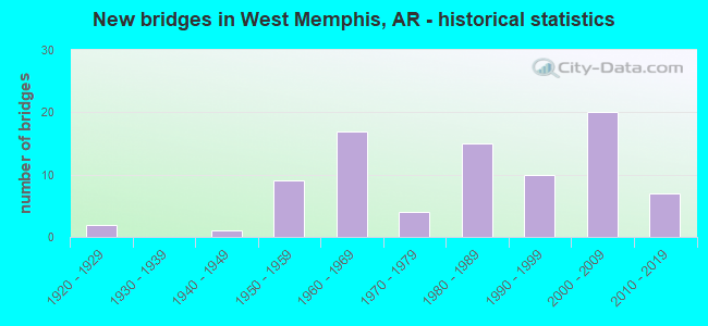
- New bridges - historical statistics
- 21920-1929
- 11940-1949
- 91950-1959
- 171960-1969
- 41970-1979
- 151980-1989
- 101990-1999
- 202000-2009
- 72010-2019
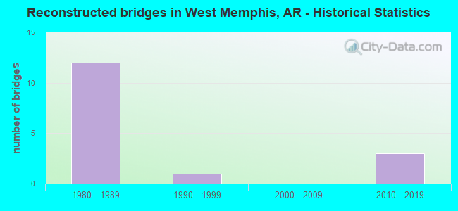
- Reconstructed bridges - Historical Statistics
- 121980-1989
- 11990-1999
- 02000-2009
- 32010-2019
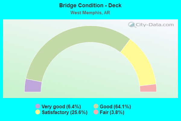
- Bridge Condition - Deck
- 6.4%Very good
- 64.1%Good
- 25.6%Satisfactory
- 3.8%Fair
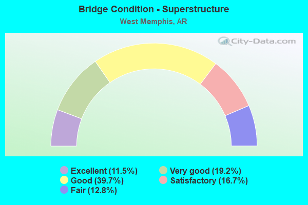
- Bridge Condition - Superstructure
- 11.5%Excellent
- 19.2%Very good
- 39.7%Good
- 16.7%Satisfactory
- 12.8%Fair
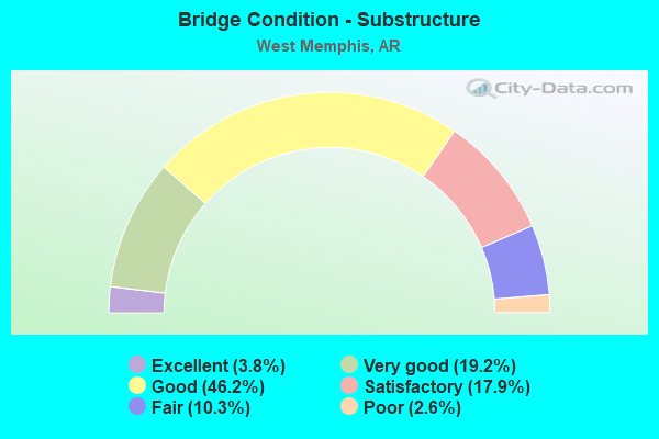
- Bridge Condition - Substructure
- 3.8%Excellent
- 19.2%Very good
- 46.2%Good
- 17.9%Satisfactory
- 10.3%Fair
- 2.6%Poor
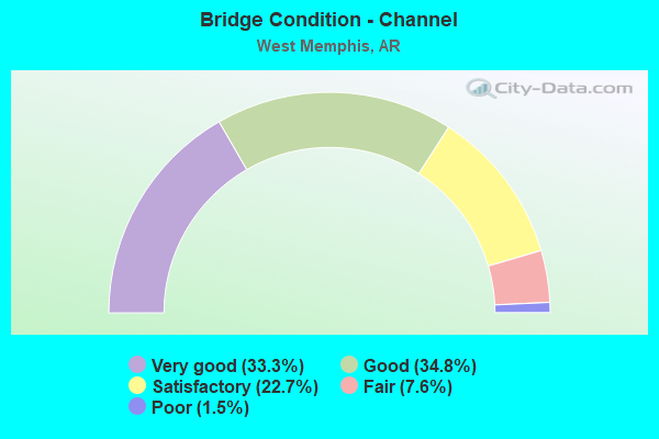
- Bridge Condition - Channel
- 33.3%Very good
- 34.8%Good
- 22.7%Satisfactory
- 7.6%Fair
- 1.5%Poor
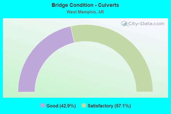
- Bridge Condition - Culverts
- 42.9%Good
- 57.1%Satisfactory
Find on map >> Show street view
Structure Number: C7025, Location: 2.2 Mi West Jct I-40 I-55 (Lat: 35.159089, Lng: -90.230319), Route carried "on" structure: Ramp Interstate 40, Year Built: 2006, Status: Open, Structure Length: 5.73m (18.80ft), Average Daily Traffic: 666 (year 2011), Truck Traffic: 1%, Average Future Daily Traffic: 2,750 (year 2028), Design Load: HS 20, Features Intersected: 15 Mile Bayou
Minimum Vertical Clearance: 30+ m (98+ ft), Kilometerpoint: 442.393, Lanes on structure: 1, Owner: State Highway Agency, Approaching Roadway Width: 10.4m (34.1ft), Skew: 4 degrees, Material/Design: Steel continuous, Design/Construction: Stringer/Multi-beam, Number Of Spans In Main Unit: 3, Length of Maximum Span: 21.0m (68.9ft), Curb-To-Curb Width: 10.4m (34.1ft), Out-to-Out Width: 11.3m (37.1ft)
Condition: Deck: Good, Superstructure: Excellent, Substructure: Very good, Channel: Very good, Operating Rating: 54.4 metric tons, Method Used To Determine Operating Rating: Load Factor (LF), Inventory Rating: 32.7 metric tons, Method Used To Determine Inventory Rating: Load Factor (LF), Structural Evaluation: Equal to present desirable criteria, Deck Geometry: Superior to present desirable criteria, Waterway Adequacy: Superior to present desirable criteria, Approach Roadway Alignment: Equal to present desirable criteria, Designated Inspection Frequency: Every 24 months, Critical Feature Inspection Frequency: Every 24 months, Inspection Date: May 2020, Deck Structure Type: Concrete Cast-file-Place, Wearing Surface/Protective System: Wearing Surface: Monolithic Concrete, Deck Protection: Epoxy Coated Reinforcing
Find on map >> Show street view
Structure Number: D7025, Location: 3.9 Mi E I-40 SH147 Jct (Lat: 35.158478, Lng: -90.230658), Route carried "on" structure: Ramp Interstate 40, Year Built: 2006, Status: Open, Structure Length: 5.73m (18.80ft), Average Daily Traffic: 1,113 (year 2011), Truck Traffic: 1%, Average Future Daily Traffic: 2,750 (year 2033), Design Load: HS 20, Features Intersected: 15 Mile Bayou
Minimum Vertical Clearance: 30+ m (98+ ft), Kilometerpoint: 442.393, Lanes on structure: 1, Owner: State Highway Agency, Approaching Roadway Width: 9.7m (31.8ft), Skew: 4 degrees, Material/Design: Steel continuous, Design/Construction: Stringer/Multi-beam, Number Of Spans In Main Unit: 3, Length of Maximum Span: 21.0m (68.9ft), Curb-To-Curb Width: 9.1m (29.9ft), Out-to-Out Width: 10.1m (33.1ft)
Condition: Deck: Good, Superstructure: Good, Substructure: Very good, Channel: Very good, Operating Rating: 54.4 metric tons, Method Used To Determine Operating Rating: Load Factor (LF), Inventory Rating: 32.7 metric tons, Method Used To Determine Inventory Rating: Load Factor (LF), Structural Evaluation: Better than present minimum criteria, Deck Geometry: Superior to present desirable criteria, Waterway Adequacy: Superior to present desirable criteria, Approach Roadway Alignment: Equal to present desirable criteria, Designated Inspection Frequency: Every 24 months, Critical Feature Inspection Frequency: Every 24 months, Inspection Date: May 2020, Deck Structure Type: Concrete Cast-file-Place, Wearing Surface/Protective System: Wearing Surface: Monolithic Concrete, Deck Protection: Epoxy Coated Reinforcing
Find on map >> Show street view
Structure Number: M1338, Location: 2.2 Mi E Jct Us 70 &Sh147 (Lat: 35.147000, Lng: -90.255622), Route carried "on" structure: US 70, Year Built: 1948, Status: Open, Structure Length: 0.79m (2.59ft), Average Daily Traffic: 4,600 (year 2018), Truck Traffic: 13%, Average Future Daily Traffic: 5,438 (year 2028), Design Load: H 20, Features Intersected: Unnamed Creek
Minimum Vertical Clearance: 30+ m (98+ ft), Kilometerpoint: 13.213, Lanes on structure: 2, Base Highway Network: Yes, Owner: State Highway Agency, Approaching Roadway Width: 12.2m (40.0ft), Material/Design: Concrete, Design/Construction: Culvert, Number Of Spans In Main Unit: 3, Length of Maximum Span: 2.4m (7.9ft)
Condition: Channel: Good, Culverts: Satisfactory, Operating Rating: 32.7 metric tons, Method Used To Determine Operating Rating: Load Factor (LF), Inventory Rating: 19.1 metric tons, Method Used To Determine Inventory Rating: Load Factor (LF), Structural Evaluation: Somewhat better than minimum adequacy, Waterway Adequacy: Equal to present desirable criteria, Approach Roadway Alignment: Equal to present desirable criteria, Designated Inspection Frequency: Every 24 months, Critical Feature Inspection Frequency: Every 24 months, Inspection Date: Febuary 2022
Find on map >> Show street view
Structure Number: X088, Location: .61 Miles North Of Us 70 (Lat: 35.155261, Lng: -90.184744), Route carried "on" structure: State highway 77, Year Built: 1995, Status: Open, Structure Length: 2.83m (9.28ft), Average Daily Traffic: 17,000 (year 2019), Truck Traffic: 1%, Average Future Daily Traffic: 20,300 (year 2038), Design Load: H 20, Features Intersected: Ten Mile Bayou
Minimum Vertical Clearance: 30+ m (98+ ft), Kilometerpoint: 27.745, Lanes on structure: 4, Base Highway Network: Yes, Owner: State Highway Agency, Approaching Roadway Width: 18.3m (60.0ft), Material/Design: Concrete, Design/Construction: Culvert, Number Of Spans In Main Unit: 5, Length of Maximum Span: 5.5m (18.0ft), Curb or Sidewalk Widths: Left: 1.8m (5.9ft), Right: 1.5m (4.9ft)
Condition: Channel: Good, Culverts: Satisfactory, Operating Rating: 38.1 metric tons, Method Used To Determine Operating Rating: Load Factor (LF), Inventory Rating: 22.7 metric tons, Method Used To Determine Inventory Rating: Load Factor (LF), Structural Evaluation: Somewhat better than minimum adequacy, Waterway Adequacy: Equal to present desirable criteria, Approach Roadway Alignment: Equal to present desirable criteria, Designated Inspection Frequency: Every 24 months, Critical Feature Inspection Frequency: Every 24 months, Inspection Date: March 2021
Find on map >> Show street view
Structure Number: X1026, Location: 0.41 Mi No Us 70 & Sh 191 (Lat: 35.152361, Lng: -90.175842), Route carried "on" structure: State highway 191, Year Built: 2000, Status: Open, Structure Length: 1.83m (6.00ft), Average Daily Traffic: 7,272 (year 2018), Truck Traffic: 1%, Average Future Daily Traffic: 8,000 (year 2038), Design Load: H 20, Features Intersected: Ten Mile Bayou
Minimum Vertical Clearance: 30+ m (98+ ft), Kilometerpoint: 0.660, Lanes on structure: 4, Owner: State Highway Agency, Approaching Roadway Width: 17.4m (57.1ft), Skew: 14 degrees, Material/Design: Concrete, Design/Construction: Culvert, Number Of Spans In Main Unit: 5, Length of Maximum Span: 3.7m (12.1ft), Curb or Sidewalk Widths: Left: 0.9m (3.0ft), Right: 0.9m (3.0ft), Curb-To-Curb Width: 17.4m (57.1ft), Out-to-Out Width: 17.7m (58.1ft)
Condition: Channel: Very good, Culverts: Satisfactory, Operating Rating: 38.1 metric tons, Method Used To Determine Operating Rating: Load Factor (LF), Inventory Rating: 22.7 metric tons, Method Used To Determine Inventory Rating: Load Factor (LF), Structural Evaluation: Somewhat better than minimum adequacy, Deck Geometry: Somewhat better than minimum adequacy, Waterway Adequacy: Equal to present desirable criteria, Approach Roadway Alignment: Equal to present desirable criteria, Designated Inspection Frequency: Every 24 months, Critical Feature Inspection Frequency: Every 24 months, Inspection Date: June 2020, Wearing Surface/Protective System: Wearing Surface: Bituminous
Find on map >> Show street view
Structure Number: X1273, Location: .22 Miles North Jct Sh 77 (Lat: 35.164600, Lng: -90.186850), Route carried "on" structure: City street 2710, Year Built: 2010, Status: Open, Structure Length: 1.85m (6.07ft), Average Daily Traffic: 1,200 (year 2019), Truck Traffic: 3%, Average Future Daily Traffic: 1,200 (year 2038), Design Load: HS 20+Mod, Features Intersected: Ten Mile Bayou Diversion, Facility Carried by Structure: Avondale Circ/W M
Minimum Vertical Clearance: 30+ m (98+ ft), Kilometerpoint: 0.354, Lanes on structure: 2, Owner: City or Municipal Highway Agency, Approaching Roadway Width: 7.9m (25.9ft), Material/Design: Concrete, Design/Construction: Culvert, Number Of Spans In Main Unit: 5, Length of Maximum Span: 3.4m (11.2ft), Curb or Sidewalk Widths: Left: 1.5m (4.9ft), Right: 1.5m (4.9ft), Curb-To-Curb Width: 7.9m (25.9ft), Out-to-Out Width: 7.9m (25.9ft)
Condition: Channel: Satisfactory, Culverts: Good, Operating Rating: 32.7 metric tons, Method Used To Determine Operating Rating: Load Factor (LF), Inventory Rating: 19.1 metric tons, Method Used To Determine Inventory Rating: Load Factor (LF), Structural Evaluation: Somewhat better than minimum adequacy, Deck Geometry: Meets minimum limits, Waterway Adequacy: Equal to present desirable criteria, Approach Roadway Alignment: Better than present minimum criteria, Designated Inspection Frequency: Every 24 months, Critical Feature Inspection Frequency: Every 24 months, Inspection Date: December 2020
Find on map >> Show street view
Structure Number: 3115, Location: 2.2 Mi E Jct Sh 147 &I-40 (Lat: 35.150789, Lng: -90.255361), Route carried "under" structure: Interstate 40, Structure Length: 0. m, Average Daily Traffic: 33,000 (year 2013), Truck Traffic: 1%, Features Intersected: I-40/Sec52/L-273.37, Facility Carried by Structure: Kuhn/Z-E/
Minimum Vertical Clearance: 5.11m (16.77ft), Kilometerpoint: 439.850, Length of Maximum Span: 0.0m
Find on map >> Show street view
Structure Number: 3115, Location: 2.2 Mi E Jct Sh 147 &I-40 (Lat: 35.150789, Lng: -90.255361), Route carried "under" structure: Interstate 40, Structure Length: 0. m, Average Daily Traffic: 33,000 (year 2013), Truck Traffic: 1%, Features Intersected: I-40/Sec52/L-273.37, Facility Carried by Structure: Kuhn/Z-E/
Minimum Vertical Clearance: 5.03m (16.50ft), Kilometerpoint: 439.850, Length of Maximum Span: 0.0m
Find on map >> Show street view
Structure Number: 3116, Location: 3.00 Mi East Jct Sh 147 (Lat: 35.156281, Lng: -90.237531), Route carried "under" structure: Interstate 40, Structure Length: 0. m, Average Daily Traffic: 33,000 (year 2013), Truck Traffic: 1%, Features Intersected: I-40/Sec-52/L-274.31, Facility Carried by Structure: Masner rd/Z-E/L.57
Minimum Vertical Clearance: 5.02m (16.47ft), Kilometerpoint: 441.459, Length of Maximum Span: 0.0m
Find on map >> Show street view
Structure Number: 3116, Location: 3.00 Mi East Jct Sh 147 (Lat: 35.156281, Lng: -90.237531), Route carried "under" structure: Interstate 40, Structure Length: 0. m, Average Daily Traffic: 33,000 (year 2013), Truck Traffic: 1%, Features Intersected: I-40/Sec-52/L-274.31, Facility Carried by Structure: Masner rd/Z-E/L.57
Minimum Vertical Clearance: 5.05m (16.57ft), Kilometerpoint: 441.459, Length of Maximum Span: 0.0m
Find on map >> Show street view
Structure Number: 3123, Location: W Memphis Interchange (Lat: 35.170139, Lng: -90.195361), Route carried "under" structure: Interstate 40, Structure Length: 0. m, Average Daily Traffic: 19,000 (year 2014), Truck Traffic: 1%, Features Intersected: I-40/Sec-52 ML
Minimum Vertical Clearance: 5.74m (18.83ft), Kilometerpoint: 445.788, Length of Maximum Span: 0.0m
Find on map >> Show street view
Structure Number: 3123, Location: W Memphis Interchange (Lat: 35.170139, Lng: -90.195361), Route carried "under" structure: Interstate 40, Structure Length: 0. m, Average Daily Traffic: 19,000 (year 2014), Truck Traffic: 1%, Features Intersected: I-40/Sec-52 ML
Minimum Vertical Clearance: 5.67m (18.60ft), Kilometerpoint: 445.788, Length of Maximum Span: 0.0m
Find on map >> Show street view
Structure Number: 313, Location: Jct Sh 191 & I-40 (Lat: 35.164539, Lng: -90.175881), Route carried "under" structure: Interstate 40, Structure Length: 0. m, Average Daily Traffic: 57,000 (year 2015), Truck Traffic: 1%, Features Intersected: I-40/Sec-52/L-278.17, Facility Carried by Structure: Sh-191/Sec-1/L1.24
Minimum Vertical Clearance: 5.26m (17.26ft), Kilometerpoint: 447.671, Length of Maximum Span: 0.0m
Find on map >> Show street view
Structure Number: 313, Location: Jct Sh 191 & I-40 (Lat: 35.164539, Lng: -90.175881), Route carried "under" structure: Interstate 40, Structure Length: 0. m, Average Daily Traffic: 57,000 (year 2019), Truck Traffic: 1%, Features Intersected: I-40/Sec-52/L-278.17, Facility Carried by Structure: Sh-191/Sec-1/L1.24
Minimum Vertical Clearance: 5.01m (16.44ft), Kilometerpoint: 447.671, Length of Maximum Span: 0.0m
Find on map >> Show street view
Structure Number: 313, Location: Jct Sh 191 & I-40 (Lat: 35.164539, Lng: -90.175881), Route carried "under" structure: ServiceInterstate 40, Structure Length: 0. m, Average Daily Traffic: 3,100 (year 2016), Truck Traffic: 1%, Features Intersected: I 40-SEC 52, Facility Carried by Structure: Sh-191/Sec-1/L1.24
Minimum Vertical Clearance: 5.37m (17.62ft), Kilometerpoint: 448.478, Length of Maximum Span: 0.0m
Find on map >> Show street view
Structure Number: 313, Location: Jct Sh 191 & I-40 (Lat: 35.164539, Lng: -90.175881), Route carried "under" structure: ServiceInterstate 40, Structure Length: 0. m, Average Daily Traffic: 12,000 (year 2019), Truck Traffic: 1%, Features Intersected: I 40-SEC 52, Facility Carried by Structure: Sh-191/Sec-1/L1.24
Minimum Vertical Clearance: 5.29m (17.36ft), Kilometerpoint: 448.478, Length of Maximum Span: 0.0m
Find on map >> Show street view
Structure Number: 5723, Location: Jct Us 70 & I-55 (Lat: 35.147189, Lng: -90.131981), Route carried "under" structure: ServiceInterstate 55, Structure Length: 0. m, Average Daily Traffic: 33,000 (year 2013), Truck Traffic: 1%, Features Intersected: I 55-SEC 11, Facility Carried by Structure: Us70/Sec-20/L15.24
Minimum Vertical Clearance: 5.18m (16.99ft), Kilometerpoint: 5.518, Length of Maximum Span: 0.0m
Find on map >> Show street view
Structure Number: 5723, Location: Jct Us 70 & I-55 (Lat: 35.147189, Lng: -90.131981), Route carried "under" structure: Interstate 55, Structure Length: 0. m, Average Daily Traffic: 16,500 (year 2013), Truck Traffic: 1%, Features Intersected: I 55-SEC 11, Facility Carried by Structure: Us70/Sec-20/L15.24
Minimum Vertical Clearance: 5.41m (17.75ft), Kilometerpoint: 5.518, Length of Maximum Span: 0.0m
Find on map >> Show street view
Structure Number: 6088, Location: 0.5 Miles South Jct I-40 (Lat: 35.150700, Lng: -90.139300), Route carried "under" structure: Interstate 55, Structure Length: 0. m, Average Daily Traffic: 16,500 (year 2013), Truck Traffic: 1%, Features Intersected: I-55-SEC 11, Facility Carried by Structure: Sh-38/Sec-10/L0.31
Minimum Vertical Clearance: 5.18m (16.99ft), Kilometerpoint: 6.309, Length of Maximum Span: 0.0m
Find on map >> Show street view
Structure Number: 6088, Location: 0.5 Miles South Jct I-40 (Lat: 35.150700, Lng: -90.139300), Route carried "under" structure: Interstate 55, Structure Length: 0. m, Average Daily Traffic: 16,500 (year 2013), Truck Traffic: 1%, Features Intersected: I-55-SEC 11, Facility Carried by Structure: Sh-38/Sec-10/L0.31
Minimum Vertical Clearance: 5.15m (16.90ft), Kilometerpoint: 6.307, Length of Maximum Span: 0.0m
Find on map >> Show street view
Structure Number: 6102, Location: W Memphis Interchange (Lat: 35.170500, Lng: -90.191450), Route carried "under" structure: Interstate 40, Structure Length: 0. m, Average Daily Traffic: 19,000 (year 2014), Truck Traffic: 1%, Features Intersected: I-40EB/Sec-52/L-277.13, Facility Carried by Structure: I-55/Sec-11/L-7.19
Minimum Vertical Clearance: 5.66m (18.57ft), Kilometerpoint: 445.998, Length of Maximum Span: 0.0m
Find on map >> Show street view
Structure Number: 6102, Location: W Memphis Interchange (Lat: 35.170500, Lng: -90.191450), Route carried "under" structure: Interstate 40, Structure Length: 0. m, Average Daily Traffic: 19,000 (year 2014), Truck Traffic: 1%, Features Intersected: I-40WB/Sec-52/L-277.13, Facility Carried by Structure: I-55/Sec-11/L-7.19
Minimum Vertical Clearance: 5.76m (18.90ft), Kilometerpoint: 445.998, Length of Maximum Span: 0.0m
Find on map >> Show street view
Structure Number: 6103, Location: 7.39 Mi West Tenn St Line (Lat: 35.172500, Lng: -90.193539), Route carried "under" structure: Ramp Interstate 40, Structure Length: 0. m, Average Daily Traffic: 20,000 (year 2005), Truck Traffic: 1%, Features Intersected: I-40/Sec-52Y/L-277.19, Facility Carried by Structure: I-55/Sec-11/L-7.39
Minimum Vertical Clearance: 4.91m (16.11ft), Kilometerpoint: 446.094, Length of Maximum Span: 0.0m
Find on map >> Show street view
Structure Number: 6457, Location: 1.09 Mi E Of Jct Sh 191 (Lat: 35.157281, Lng: -90.157011), Route carried "under" structure: Interstate 40, Structure Length: 0. m, Average Daily Traffic: 57,000 (year 2019), Truck Traffic: 1%, Features Intersected: I-40 MN LNS & FR RDS, Facility Carried by Structure: Ingram/L-0.18
Minimum Vertical Clearance: 5.22m (17.13ft), Kilometerpoint: 449.426, Length of Maximum Span: 0.0m
Find on map >> Show street view
Structure Number: 6457, Location: 1.09 Mi E Of Jct Sh 191 (Lat: 35.157281, Lng: -90.157011), Route carried "under" structure: Interstate 40, Structure Length: 0. m, Average Daily Traffic: 57,000 (year 2019), Truck Traffic: 1%, Features Intersected: I-40 MN LNS & FR RDS, Facility Carried by Structure: Ingram/L-0.18
Minimum Vertical Clearance: 5.40m (17.72ft), Kilometerpoint: 449.426, Length of Maximum Span: 0.0m
Find on map >> Show street view
Structure Number: 6457, Location: 1.09 Mi E Of Jct Sh 191 (Lat: 35.157281, Lng: -90.157011), Route carried "under" structure: ServiceInterstate 40, Structure Length: 0. m, Average Daily Traffic: 3,100 (year 2019), Truck Traffic: 1%, Features Intersected: I-40 MN LNS & FR RDS, Facility Carried by Structure: Ingram/L-0.18
Minimum Vertical Clearance: 5.20m (17.06ft), Kilometerpoint: 449.426, Length of Maximum Span: 0.0m
Find on map >> Show street view
Structure Number: 6457, Location: 1.09 Mi E Of Jct Sh 191 (Lat: 35.157281, Lng: -90.157011), Route carried "under" structure: ServiceInterstate 40, Structure Length: 0. m, Average Daily Traffic: 12,000 (year 2019), Truck Traffic: 1%, Features Intersected: I-40 MN LNS & FR RDS, Facility Carried by Structure: Ingram/L-0.18
Minimum Vertical Clearance: 5.07m (16.63ft), Kilometerpoint: 449.426, Length of Maximum Span: 0.0m
Find on map >> Show street view
Structure Number: 7026, Location: 4.07 Mi E Jct I-40 & 147 (Lat: 35.161269, Lng: -90.224297), Route carried "under" structure: Interstate 40, Structure Length: 0. m, Average Daily Traffic: 18,500 (year 2014), Truck Traffic: 1%, Features Intersected: I-40WB/Sec-52/L-275.24, Facility Carried by Structure: Sh-118/Sec-4/L3.13
Minimum Vertical Clearance: 5.54m (18.18ft), Kilometerpoint: 442.956, Length of Maximum Span: 0.0m
Find on map >> Show street view
Structure Number: 7026, Location: 4.07 Mi E Jct I-40 & 147 (Lat: 35.161269, Lng: -90.224297), Route carried "under" structure: Ramp Interstate 40, Structure Length: 0. m, Average Daily Traffic: 18,500 (year 2014), Truck Traffic: 1%, Features Intersected: I-40, Facility Carried by Structure: Sh-118/Sec-4/L3.13
Minimum Vertical Clearance: 5.51m (18.08ft), Kilometerpoint: 442.956, Length of Maximum Span: 0.0m
Find on map >> Show street view
Structure Number: 7026, Location: 4.07 Mi E Jct I-40 & 147 (Lat: 35.161269, Lng: -90.224297), Route carried "under" structure: Ramp Interstate 40, Structure Length: 0. m, Average Daily Traffic: 18,500 (year 2014), Truck Traffic: 1%, Features Intersected: I-40, Facility Carried by Structure: Sh-118/Sec-4/L3.13
Minimum Vertical Clearance: 5.61m (18.41ft), Kilometerpoint: 442.956, Length of Maximum Span: 0.0m
Find on map >> Show street view
Structure Number: 7026, Location: 4.07 Mi E Jct I-40 & 147 (Lat: 35.161269, Lng: -90.224297), Route carried "under" structure: Interstate 40, Structure Length: 0. m, Average Daily Traffic: 18,500 (year 2014), Truck Traffic: 1%, Features Intersected: I-40EB/Sec-52/L-275.24, Facility Carried by Structure: Sh-118/Sec-4/L3.13
Minimum Vertical Clearance: 5.39m (17.68ft), Kilometerpoint: 442.956, Length of Maximum Span: 0.0m
Find on map >> Show street view
Structure Number: 707, Location: 3 Mi E OF JCT I-55 & I-40 (Lat: 35.153808, Lng: -90.106461), Route carried "under" structure: Other road 312, Structure Length: 0. m, Truck Traffic: 1%, Features Intersected: CO. RD, MISS RELIEF, RR, Facility Carried by Structure: I 40-SEC 52
Minimum Vertical Clearance: 8.83m (28.97ft), Kilometerpoint: 1.609, Length of Maximum Span: 0.0m
Find on map >> Show street view
Structure Number: 707, Location: 3 Mi E OF JCT I-55 & I-40 (Lat: 35.153808, Lng: -90.106461), Route carried "under" structure: County highway 312, Structure Length: 0. m, Average Daily Traffic: 10 (year 2009), Truck Traffic: 1%, Features Intersected: CO. RD, MISS RELIEF, RR, Facility Carried by Structure: I 40-SEC 52
Minimum Vertical Clearance: 9.19m (30.15ft), Kilometerpoint: 1.642, Length of Maximum Span: 0.0m
Find on map >> Show street view
Structure Number: A3108, Location: Jct Sh 147 & I-40 (Lat: 35.148022, Lng: -90.293153), Route carried "under" structure: State highway 147, Structure Length: 0. m, Average Daily Traffic: 1,800 (year 2019), Truck Traffic: 1%, Features Intersected: Sh-147/Sec-2/L-0.02, Facility Carried by Structure: I-40WB/Se52/271.09
Minimum Vertical Clearance: 4.54m (14.90ft), Kilometerpoint: 0.032, Length of Maximum Span: 0.0m
Find on map >> Show street view
Structure Number: A3108, Location: Jct Sh 147 & I-40 (Lat: 35.148022, Lng: -90.293153), Route carried "under" structure: State highway 147, Structure Length: 0. m, Average Daily Traffic: 1,800 (year 2019), Truck Traffic: 1%, Features Intersected: Sh-147/Sec-2/L-0.02, Facility Carried by Structure: I-40WB/Se52/271.09
Minimum Vertical Clearance: 4.56m (14.96ft), Kilometerpoint: 0.032, Length of Maximum Span: 0.0m
Find on map >> Show street view
Structure Number: A3126, Location: JCT SH77 05 16.54 & I 40 (Lat: 35.167778, Lng: -90.183206), Route carried "under" structure: State highway 77, Structure Length: 0. m, Average Daily Traffic: 9,500 (year 2014), Truck Traffic: 1%, Features Intersected: SH 77, BN RR, Facility Carried by Structure: I 40, EB LNS
Minimum Vertical Clearance: 6.64m (21.78ft), Kilometerpoint: 26.329, Length of Maximum Span: 0.0m
Find on map >> Show street view
Structure Number: A3126, Location: JCT SH77 05 16.54 & I 40 (Lat: 35.167778, Lng: -90.183206), Route carried "under" structure: State highway 77, Structure Length: 0. m, Average Daily Traffic: 9,500 (year 2014), Truck Traffic: 1%, Features Intersected: SH 77, BN RR, Facility Carried by Structure: I 40, EB LNS
Minimum Vertical Clearance: 7.10m (23.29ft), Kilometerpoint: 26.628, Length of Maximum Span: 0.0m
Find on map >> Show street view
Structure Number: A5014, Location: 1 Mile North East Of I-55 (Lat: 35.156311, Lng: -90.136519), Route carried "under" structure: State highway 38, Structure Length: 0. m, Average Daily Traffic: 14,000 (year 2019), Truck Traffic: 1%, Features Intersected: Sh-38/Sec-10 /0.74, Facility Carried by Structure: I-40WB/Se52/280.52
Minimum Vertical Clearance: 4.56m (14.96ft), Kilometerpoint: 1.191, Length of Maximum Span: 0.0m
Find on map >> Show street view
Structure Number: A5014, Location: 1 Mile North East Of I-55 (Lat: 35.156311, Lng: -90.136519), Route carried "under" structure: State highway 38, Structure Length: 0. m, Average Daily Traffic: 14,000 (year 2019), Truck Traffic: 1%, Features Intersected: SH 38 / MLK Dr., Facility Carried by Structure: I-40WB/Se52/280.52
Minimum Vertical Clearance: 4.54m (14.90ft), Kilometerpoint: 1.191, Length of Maximum Span: 0.0m
Find on map >> Show street view
Structure Number: A5015, Location: 1 MI NE OF I-40 (Lat: 35.156331, Lng: -90.133111), Route carried "under" structure: State highway 131, Structure Length: 0. m, Average Daily Traffic: 1,100 (year 2014), Truck Traffic: 1%, Features Intersected: SH 131, UN PAC RR, Facility Carried by Structure: I 40-SEC 52, EB LN
Minimum Vertical Clearance: 4.78m (15.68ft), Kilometerpoint: 1.094, Length of Maximum Span: 0.0m
Find on map >> Show street view
Structure Number: A5528, Location: 1.8 E JCT I-40 (Lat: 35.145181, Lng: -90.120800), Route carried "under" structure: ServiceCity street , Structure Length: 0. m, Features Intersected: I-55, Facility Carried by Structure: I-55, NB LNS
Minimum Vertical Clearance: 6.67m (21.88ft), Kilometerpoint: 0.000, Length of Maximum Span: 0.0m
Find on map >> Show street view
Structure Number: A5528, Location: 1.8 E JCT I-40 (Lat: 35.145181, Lng: -90.120800), Route carried "under" structure: ServiceCity street , Structure Length: 0. m, Features Intersected: I-55, Facility Carried by Structure: I-55, NB LNS
Minimum Vertical Clearance: 4.34m (14.24ft), Kilometerpoint: 0.000, Length of Maximum Span: 0.0m
Find on map >> Show street view
Structure Number: A5528, Location: 1.8 E JCT I-40 (Lat: 35.145181, Lng: -90.120800), Route carried "under" structure: Other road , Structure Length: 0. m, Features Intersected: I-55, Facility Carried by Structure: I-55, NB LNS
Minimum Vertical Clearance: 7.16m (23.49ft), Kilometerpoint: 0.000, Length of Maximum Span: 0.0m
Find on map >> Show street view
Structure Number: A6984, Location: Jct I-40 & I-55 W Memphis (Lat: 35.155300, Lng: -90.148200), Route carried "under" structure: Interstate 55, Structure Length: 0. m, Average Daily Traffic: 31,000 (year 2014), Truck Traffic: 1%, Features Intersected: I-55 NB Lns, Facility Carried by Structure: I-40WB/Se52/279.96
Minimum Vertical Clearance: 5.36m (17.59ft), Kilometerpoint: 7.113, Length of Maximum Span: 0.0m
Find on map >> Show street view
Structure Number: B3108, Location: Jct I-40 & Sh 147 (Lat: 35.147789, Lng: -90.293150), Route carried "under" structure: State highway 147, Structure Length: 0. m, Average Daily Traffic: 1,250 (year 2014), Truck Traffic: 1%, Features Intersected: Sh-147/Sec-2/L-0.04, Facility Carried by Structure: I-40EB/Se52/271.17
Minimum Vertical Clearance: 4.57m (14.99ft), Kilometerpoint: 0.064, Length of Maximum Span: 0.0m
Find on map >> Show street view
Structure Number: B3108, Location: Jct I-40 & Sh 147 (Lat: 35.147789, Lng: -90.293150), Route carried "under" structure: State highway 147, Structure Length: 0. m, Average Daily Traffic: 1,250 (year 2014), Truck Traffic: 1%, Features Intersected: Sh-147/Sec-2/L-0.04, Facility Carried by Structure: I-40EB/Se52/271.17
Minimum Vertical Clearance: 4.59m (15.06ft), Kilometerpoint: 0.064, Length of Maximum Span: 0.0m
Find on map >> Show street view
Structure Number: B3126, Location: JCT SH 77 & I-40 (Lat: 35.167911, Lng: -90.183131), Route carried "under" structure: ServiceInterstate 40, Structure Length: 0. m, Average Daily Traffic: 54,000 (year 2014), Truck Traffic: 1%, Features Intersected: SH 77, BN RR
Minimum Vertical Clearance: 7.10m (23.29ft), Kilometerpoint: 446.611, Length of Maximum Span: 0.0m
Find on map >> Show street view
Structure Number: B3126, Location: JCT SH 77 & I-40 (Lat: 35.167911, Lng: -90.183131), Route carried "under" structure: State highway 77, Structure Length: 0. m, Average Daily Traffic: 19,000 (year 2014), Truck Traffic: 1%, Features Intersected: SH 77, BN RR, Facility Carried by Structure: I 40-SEC 52, WB LN
Minimum Vertical Clearance: 6.64m (21.78ft), Kilometerpoint: 26.313, Length of Maximum Span: 0.0m
Find on map >> Show street view
Structure Number: B5014, Location: 1 Mile Ne Of Jct I-55 (Lat: 35.156139, Lng: -90.136650), Route carried "under" structure: State highway 38, Structure Length: 0. m, Average Daily Traffic: 14,000 (year 2021), Truck Traffic: 25%, Features Intersected: Sh-38/Sec-10/L-0.72, Facility Carried by Structure: I-40EB/Se52/280.52
Minimum Vertical Clearance: 4.51m (14.80ft), Kilometerpoint: 1.159, Length of Maximum Span: 0.0m
Find on map >> Show street view
Structure Number: B5014, Location: 1 Mile Ne Of Jct I-55 (Lat: 35.156139, Lng: -90.136650), Route carried "under" structure: State highway 38, Structure Length: 0. m, Average Daily Traffic: 14,000 (year 2019), Truck Traffic: 1%, Features Intersected: Sh-38/Sec-10/L-0.72, Facility Carried by Structure: I-40EB/Se52/280.52
Minimum Vertical Clearance: 4.59m (15.06ft), Kilometerpoint: 1.159, Length of Maximum Span: 0.0m
Find on map >> Show street view
Structure Number: B5015, Location: 1 MI NE OF I-55 (Lat: 35.156550, Lng: -90.133131), Route carried "under" structure: State highway 131, Structure Length: 0. m, Features Intersected: SH 131, UN PAC RR, Facility Carried by Structure: I 40-SEC 52, WB LN
Minimum Vertical Clearance: 4.78m (15.68ft), Kilometerpoint: 1.078, Length of Maximum Span: 0.0m
Find on map >> Show street view
Structure Number: B5015, Location: 1 MI NE OF I-55 (Lat: 35.156550, Lng: -90.133131), Route carried "under" structure: Other road , Structure Length: 0. m, Features Intersected: SH 131, UN PAC RR, Facility Carried by Structure: I 40-SEC 52, WB LN
Minimum Vertical Clearance: 7.01m (23.00ft), Kilometerpoint: 1.400, Length of Maximum Span: 0.0m
Find on map >> Show street view
Structure Number: B5528, Location: 1.8 E JCT I-40 (Lat: 35.145081, Lng: -90.120850), Route carried "under" structure: ServiceCity street , Structure Length: 0. m, Average Daily Traffic: 200 (year 0000), Truck Traffic: 1%, Features Intersected: CRI&P & MISS RIV REL, Facility Carried by Structure: I-55, SB LNS
Minimum Vertical Clearance: 6.97m (22.87ft), Kilometerpoint: 3.460, Length of Maximum Span: 0.0m
Find on map >> Show street view
Structure Number: B5528, Location: 1.8 E JCT I-40 (Lat: 35.145081, Lng: -90.120850), Route carried "under" structure: Other road , Structure Length: 0. m, Features Intersected: I-55 S, Facility Carried by Structure: I-55, SB LNS
Minimum Vertical Clearance: 7.16m (23.49ft), Kilometerpoint: 4.281, Length of Maximum Span: 0.0m
Find on map >> Show street view
Structure Number: B5528, Location: 1.8 E JCT I-40 (Lat: 35.145081, Lng: -90.120850), Route carried "under" structure: ServiceOther road , Structure Length: 0. m, Average Daily Traffic: 20 (year 0000), Truck Traffic: 1%, Features Intersected: Bridgeport Rd, Facility Carried by Structure: I-55, SB LNS
Minimum Vertical Clearance: 4.31m (14.14ft), Kilometerpoint: 4.571, Length of Maximum Span: 0.0m
Find on map >> Show street view
Structure Number: B6984, Location: Jct I-40 & I-55 West Memp (Lat: 35.155131, Lng: -90.147811), Route carried "under" structure: Interstate 55, Structure Length: 0. m, Average Daily Traffic: 31,000 (year 2014), Truck Traffic: 26%, Features Intersected: I-55 NB Lns, Facility Carried by Structure: I-40EB/Se52/279.69
Minimum Vertical Clearance: 5.42m (17.78ft), Kilometerpoint: 7.113, Length of Maximum Span: 0.0m